Addendum to: Transport Access and Parking Delivery Work Plan (Contract 2.1/2.2) (dated November 2017)
CRL-AOT-RME-LKA-PLN-800014
Revision: 1.0
Date: 7 November 2019
Transport Access and Parking Delivery Work Plan
CRL-AOT-RME-LKA-PLN-800014
This document is uncontrolled when printed. This document should be printed in colour
Revision Status
Approval Status Name/Title
1. Introduction
1.1 Overview
The City Rail Link (CRL) project comprises the construction, operation and maintenance of a 3.4km twin-tunnel underground passenger railway, running between Britomart Station and the North Auckland Line (NAL) in the vicinity of Mt Eden Station. The CRL involves the construction of two new underground stations at Aotea and Karangahape, and a redeveloped station at Mt Eden. The design and construction of the CRL infrastructure between the Aotea and Mt Eden Stations is being delivered by the Link Alliance.
In 2017, City Rail Link Limited (CRLL) submitted an outline plan for canopy removal and utility relocation works within the Aotea Station area, along the western side of Albert Street between Victoria Street West and Wellesley Street West (Auckland Council ref. OPW60310921). This outline plan was accepted by Auckland Council without changes. Canopy removal works have now been completed.
Additional utility relocation and canopy removal works are required beyond the footprint of the approved works. As such, the Link Alliance is seeking authorisation for works that are beyond the scope of OPW60310921.
1.2 Purpose of the TAP DWP Addendum
This addendum updates the “Contract 2.1/2.2 – Albert Street Canopy Removals and Utilities Relocation: Transport Access and Parking Delivery Work Plan” (Document Reference: CRL-PAT-RME000-RPT-0097), dated November 2017 and prepared by Flow Transportation Specialists, (“the Approved TAP DWP”) to address the additional utility and canopy works.
This TAP DWP addendum should be read in conjunction with the Approved TAP DWP. The section numbering within the addendum follows the same convention as the Approved TAP DWP.
2. Purpose and Objectives of Delivery Work Plan
No changes or additions are required to Section 2 of the Approved TAP DWP.
3. CRL Designation Condition Requirements
The following CRL designation conditions in Table 1 below are relevant to works described in this addendum, in addition to those already outlined within the Approved TAP DWP.
Table 1 CRL Designation Condition Requirements
Number Condition
25 General Transport, Access and Parking
25.3 (h) (ii) Relocating bus stops and taxi stands to locations which, as far as practicably possible, minimise disruption
Section Addressed within this Document
Section 7.3
4. Project Works
4.1 Introduction
The project site applicable to this TAP DWP addendum is located within Albert Street and the adjoining streets, between Wyndham Street and Mayoral Drive The Stage 4 and 5 utility relocation works, canopy removal works and Construction Support Area establishment (herein referred to as the ‘Stage 4 and 5 works’) involves the following main activities:
• Canopy removal;
• Utility relocation activities via trenching;
• Utility relocation activities via micro-tunnelling within Victoria Street West;
• Closure of the Albert Street / Wellesley Street intersection to undertake east-west and north-south trenching works for utility relocation;
• Closure of the southern slip lane from Durham Street to Albert Street for approximately 4 to 6 weeks to allow for utility relocation;
• Closure of Kingston Street for approximately 4 to 6 weeks to allow for utility relocation;
• Directional drilling along Wellesley Street between Albert Street and Federal Street, and;
• Establishment of a construction compound to support the subsequent main station construction works.
The Stage 4 and 5 works will be undertaken along parts of Albert Street, Kingston Street, Victoria Street West, Wellesley Street and Mayoral Drive. In addition, a construction compound (herein referred to as the ‘Construction Support Area’ (CSA)) required to support the main works is to be established within the outdoor car park area to the west of Bledisloe House. The site adjoins the project area of the canopy and utility works authorised by OPW60310921.
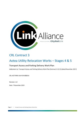
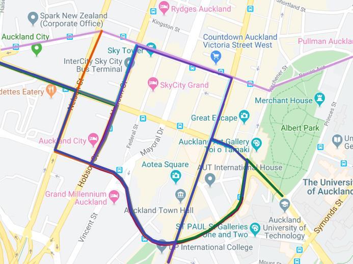
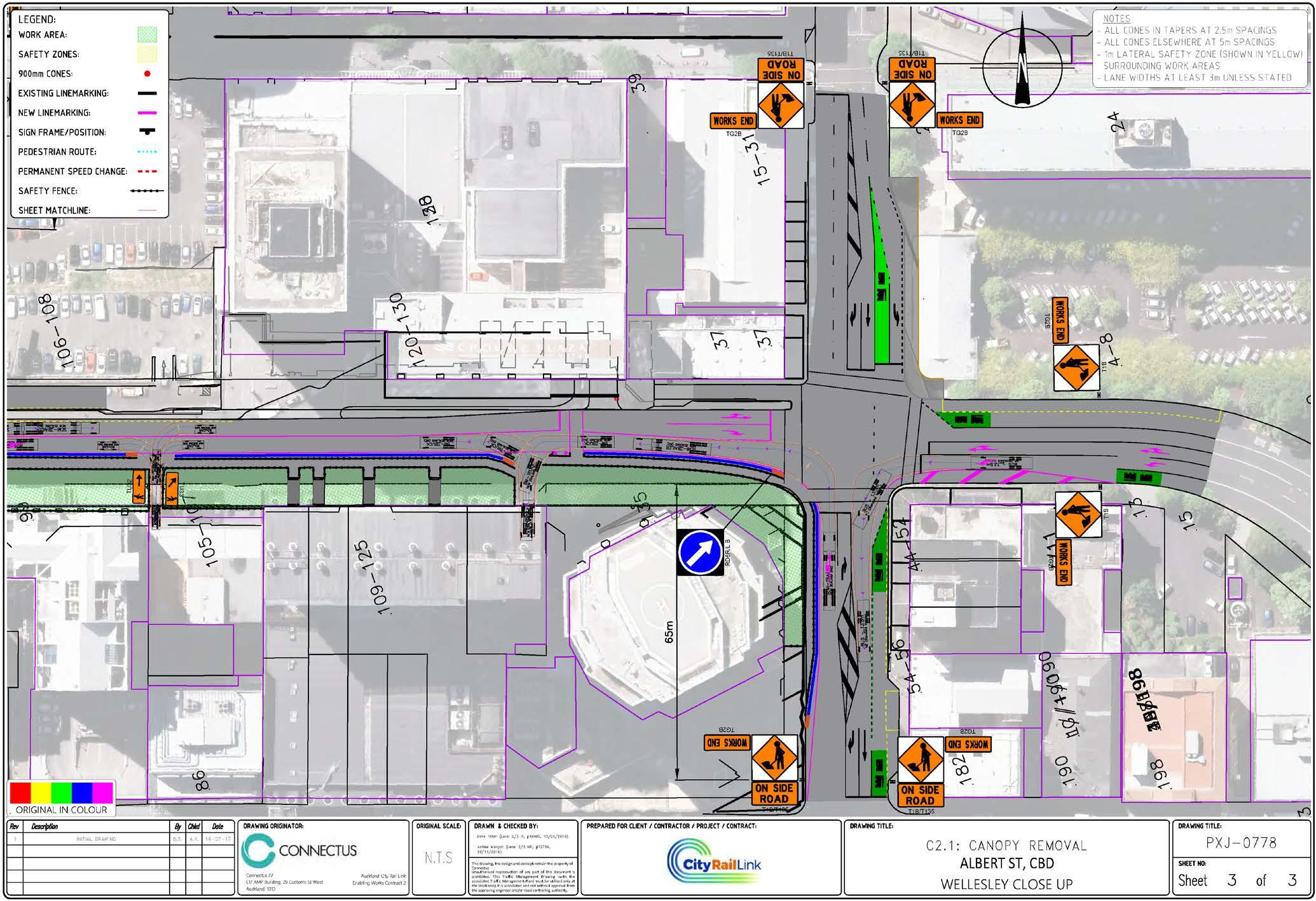
The area of the Stage 4 and 5 works is illustrated in Figure 1, below.
The area surrounding the project site is a dense urban environment with a built form comprised of medium to high rise buildings. Common land uses in the project area include commercial offices and services, residential apartments, retail, civic, hospitality, hotel accommodation and car parking. Along Albert Street multiple active construction sites are present including for the CRL and private
Figure 1 Site Location
development. Buildings adjoin much of the project site boundary (road corridor) forming active frontages that provide access to private property and businesses.
The area of works is highly utilised by pedestrians and vehicles, both for private and business purposes. Albert Street, Victoria Street West, Wellesley Street West and Mayoral Drive are classified as primary arterial roads. Kingston Street and Durham Street West are classified as local roads.
4.2 General Project Works
The methodology for utility relocation and canopy removal proposed during the Stage 4 and 5 works is essentially the same as set out in the Approved Construction Environmental Management Plan (CEMP).
A full description of the methodology associated with the Stage 4 and 5 works is provided in Section 2.3 of the CEMP addendum. This includes a description of the Stage 4 and 5 works which are beyond the scope of works described in the Approved CEMP. Staging plans and site layouts for each stage of the works are provided in Appendix C of the CEMP addendum
4.3 Hours of Operation
Works will generally be undertaken between 0700hrs and 1900hrs Monday to Saturday, taking into account any specific construction noise or traffic, access and parking restrictions outlined in the CRL designation conditions. Limited construction related activities may be undertaken outside these hours, such as the delivery of oversized plant as detailed in the CEMP, providing they comply with the relevant designation conditions.
4.4 Construction Workforce
The construction workforce required for the Stages 4 and 5 utility works will vary over the duration of the works, however it is expected to peak at approximately 40 staff. This number includes subcontractor workforces, such as traffic management, and staff from the various network utility operators, who will be on-site intermittently during the works. Limited workforce parking will be provided within the site compound at Bledisloe carpark. The majority of workers will need to either park within nearby public parking buildings or travel via other transport modes. Vehicle access to construction zones will be restricted to plant and material delivery, spoil removal and utility service vehicles.
4.5 Work Travel Demand Management
It is expected that the traffic effects of workforce travel will be minor given the size of the workforce for Stages 4 and 5. The need for individual vehicle trips can be further minimised through the use of public transport and carpooling. The project workforce will be provided with public transport travel information and encouraged to carpool where practical.
5. Existing Conditions
5.1 General
The traffic conditions in Albert Street have been altered as a result of the CRL Contract 2 works in lower Albert Street
For the purpose of this addendum, the existing conditions are in reference to the current on-street layout (as at September 2019).
5.1.1. Traffic movements
The Stage 4 and 5 works affect Albert Street, Victoria Street West, Wellesley Street West and Mayoral Drive, as well as Kingston Street and Durham Street West. Table 2 outlines the road classification according to the Auckland Unitary Plan (AUP) and Annual Average Daily Traffic (AADT) of those roads.
Table 2: Stage 4 and 5 proposed works
Signalised intersections provide for traffic and pedestrian movements at the intersections of Albert Street and Victoria Street West, Albert Street and Wellesley Street, Victoria Street West and Federal Street and Victoria Street West and Elliott Street.
Kingston Street provides one-way traffic movements from west to east. Durham Street West (between Durham Lane and Queen Street) is also one-way running from east to west.
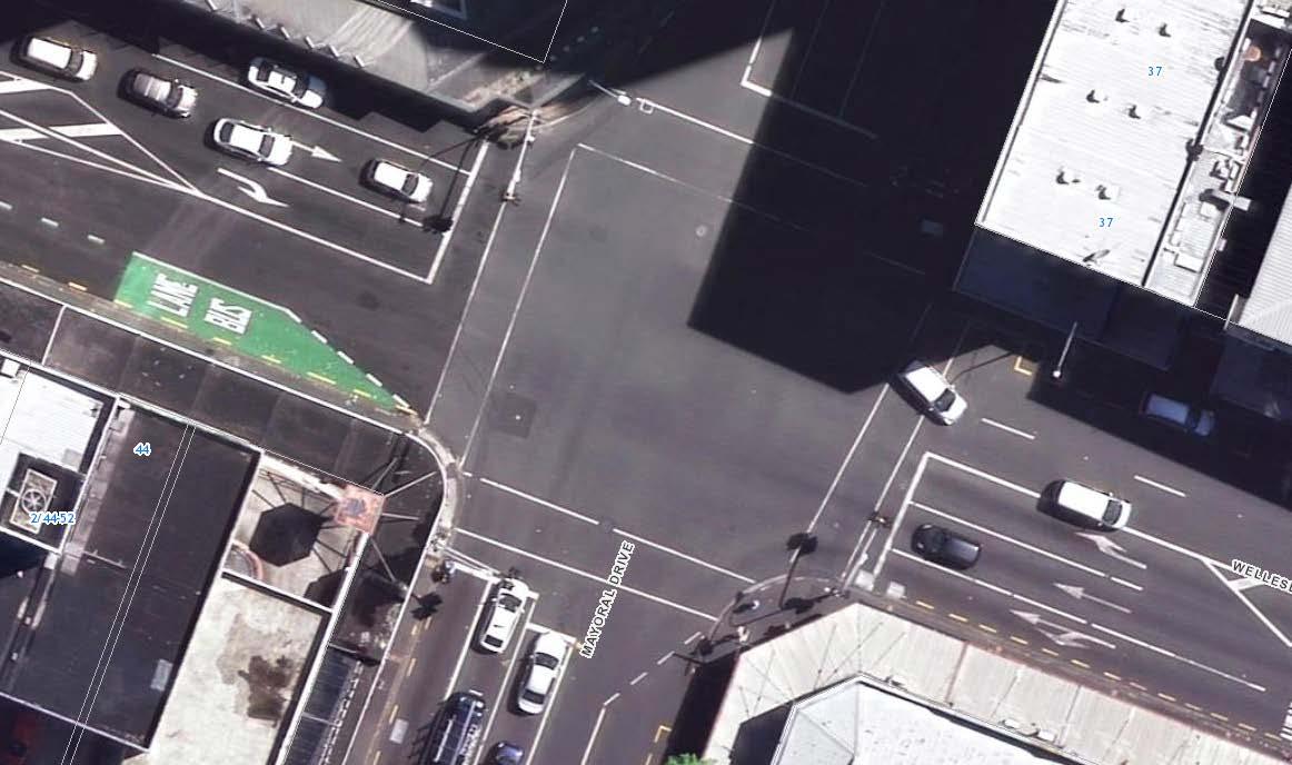
Albert Street contains a slip lane which runs between Wyndham Street and Victoria Street West, and a service lane which runs between Victoria Street West and Wellesley Street West. Both run one-way from north to south.
5.1.2. Parking
On Albert Street, parking is prohibited within the area subject to works including the Albert Street slip lane north of Victoria Street West. On Victoria Street West (west of Albert Street), parking is prohibited except for a loading zone on the northern side and a bus stop on the southern side. Victoria Street West (east of Albert Street) has a loading zone (approx. 18 m), car share parking and on-street paid parking on the northern side, while the southern side contains a bus stop.
On Wellesley Street West (west of Albert Street) parking is prohibited within the area subject to works except for a bus stop and loading zone on the northern side, and a bus stop on the southern side. On Wellesley Street West (between Albert Street and Elliott Street), parking is prohibited except for a loading zone (approx. 12 m) and bus stop on the northern side, and a loading zone on the southern side.
On Mayoral Drive, parking is prohibited in the area subject to works except for a bus stop on the eastern side.
The southern side of Kingston Street (between Federal Street and Albert Street) contains a loading zone. On both sides, the remainder of Kingston Street has on-street paid parking available.
5.1.3. Bus routes
Since mid-2018 some of the bus routes in central Auckland have changed as a result of the implementation of Auckland Transport’s New Network. The effect of these changes was taken into account within the Approved TAP DWP. For clarity the bus route changes can be summarised as:
• Albert Street currently does not have any bus routes running along it, instead the bus routes now operate on Victoria Street West and Wellesley Street.
Of these bus routes running along Victoria Street and Wellesley Street, the following is a summary:
• Six bus routes operate on Victoria Street West and eighteen bus routes operate on Wellesley Street.
• There are a further seven routes (22, 24, 75, 221X, 223X, 243X, 248X) that run on both streets, giving a total of thirty-one different routes operating on Victoria Street West and Wellesley Street
Therefore, both Victoria Street West and Wellesley Street West are strategically significant for public transport services within the City Centre.
Due to the closure of the Wellesley Street West/ Albert Street intersection in stages 4B and 5, buses will be rerouted off Wellesley Street. This will result in the existing bus stops on Wellesley Street West (between Hobson Street and Queen Street) being redundant.
5.2 Walking and Cycling Facilities
5.2.1. Walking Facilities
Albert Street, Wellesley Street, Victoria Street West, Mayoral Drive and Kingston Street all have footpaths along both sides of the road. Current construction work as part of CRL Contract 2 has restricted sections of the footpath along the western side of Albert Street and the southern side of Victoria Street West. This has been mitigated by providing temporary pedestrian access ways and footpaths adjacent to work zones, as well as providing pedestrian access to all private properties.
The footpaths affected by the proposed Stage 4 and 5 work zones under this addendum serve three main functions:
• Access function: Providing access to properties located along these roads
• Through function: Providing a through route for pedestrians to walk to destinations in other areas
• Public transport function: The footpaths on Victoria Street West provide access to/from public transport facilities, including providing waiting space for public buses.
The footpaths on these roads and adjacent to the work zones are not observed to provide much of a place function, as there are no facilities provided for pedestrians to linger and interact. In addition, current CRL construction works have already reduced the width of some footpaths in the area and hence limited space is available for this function.
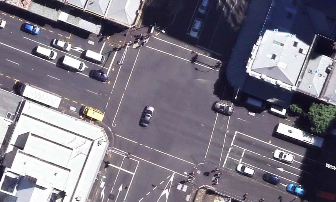
A signalised Barnes Dance pedestrian crossing is located at the Wyndham Street/ Albert Street, Victoria Street/Albert Street, and Wellesley Street/Albert Street intersections, as well as a signalised midblock pedestrian crossing on Albert Street approximately 50m north of Wellesley Street. These provide good connectivity for pedestrians.
5.2.2. Cycling Facilities
There are few dedicated cycling facilities in the immediate area of works. There are cycle advance stop boxes on the Victoria Street approaches to the Albert Street/Victoria Street intersection, as well as cycle advance stop boxes on both sides of the pedestrian crossing located 85m east of the same intersection.
Federal Street (south of Victoria Street West) and Elliot Street are shared use environments and cycle lanes are provided on Federal Street to the north of Victoria Street West, providing an alternative dedicated parallel route for cyclists.
Wellesley Street West and Mayoral Drive (in the project area) do not have any cycling facilities.
6. Proposed Traffic Management
6.1 Philosophy
No changes or additions are required to Section 6.1 of the Approved TAP DWP.
6.2
General Traffic Management
The Stage 4 and 5 works will be undertaken in three sub-stages (4A, 4B, 5) over a period of approximately 9 months. Across all stages, the works will generally occupy the majority of the footpath (in areas where work zones are present), but a pedestrian route a minimum of 1.5m wide will be maintained.
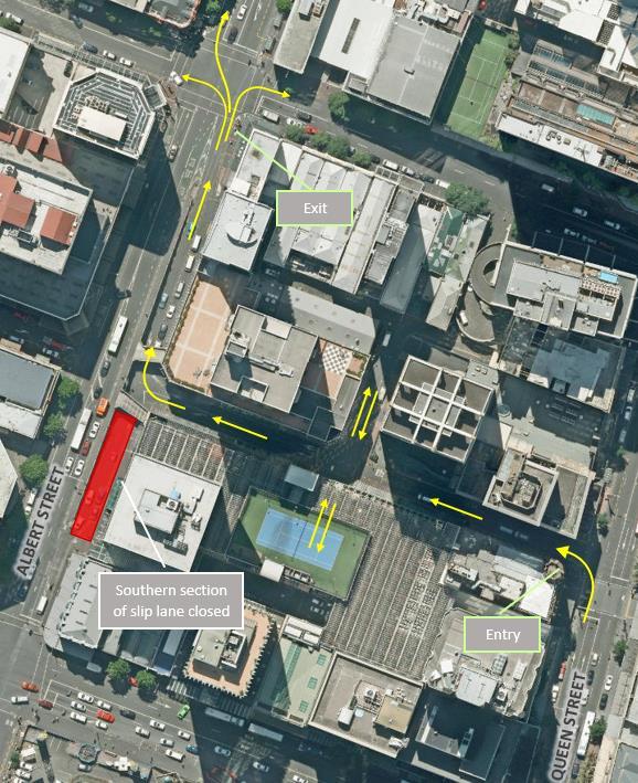
Stage 4A will require the closure of the southern section of the Albert Street slip lane (off Durham Street West) and Kingston Street for up to 6 weeks. Detour routes and plans will be developed to manage the temporary closure and to inform consultation with affected parties. Pedestrian movements will continue to be provided (through 1.5m wide footpaths). Canopy removal will be undertaken along Albert, Victoria and Wellesley Streets and this will require occupation of the majority of the footpath, however existing traffic movements and pedestrians will continue to be available. The establishment of the CSA in the Bledisloe House car park will require a Traffic Management Plan (TMP) to be implemented along Mayoral Drive, however one lane each way on Mayoral Drive will be maintained.
Stages 4B and 5 involve the closure of the Albert Street/ Wellesley Street intersection to traffic. Work zones from stage 4A will be disestablished prior to commencement of stage 4B. Traffic will still be permitted along the Albert Street service lane (below Crowne Plaza), and vehicles will be able to exit via a left turn onto Wellesley Street West.
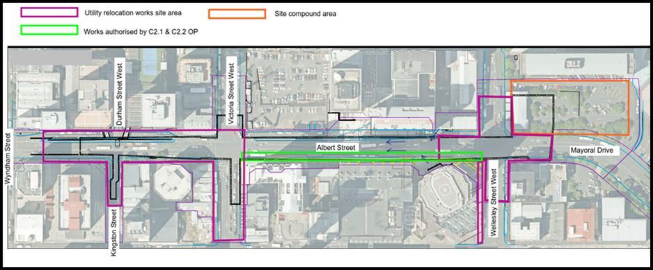
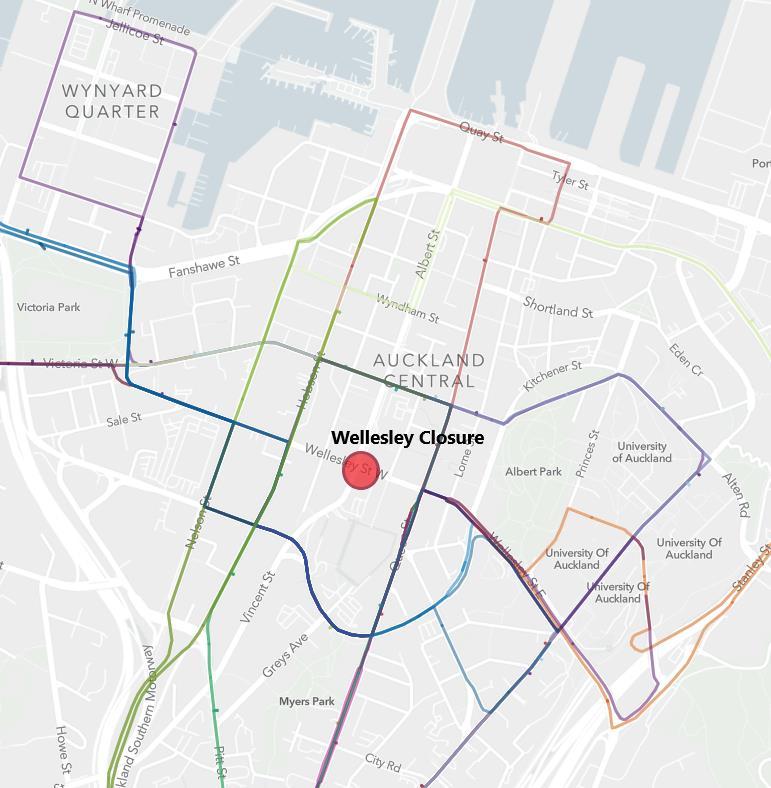
Traffic in the vicinity of the Wellesley Street West/ Albert Street intersection during the closure will be diverted. An indicative diversion route is provided in Figure 2. Note: this is subject to change.
Full pedestrian access across the Albert Street/ Wellesley Street West intersection will be maintained at all times during the works. Traffic management areas interfacing with pedestrian crossing points will widen to cater for the crossing demand as required during the works and wayfinding signage will be provided where required.
Where practical, TMP’s will ensure all pedestrian routes will meet accessibility requirements, with appropriate ramps and gradients for all users.
Figure 2 Indicative diversion route for the closure of Wellesley Street/Albert Street intersection
6.3 Construction Traffic
Truck loading will occur via the proposed vehicle access points indicated on the temporary traffic management plans. Conflicts between pedestrians, private vehicles and construction activity will be managed by a Traffic Controller at each works site access (during active site hours).
Overall, the volume of construction traffic generated by the Stage 4 and 5 works is predicted to be very low, in the order of 18-20 truck deliveries per day (i.e. 36-40 one-way movements). These movements will be occurring between 7:00 am and 7:00 pm, Monday to Saturday.
As outlined in the Approved TAP DWP truck movements will be via the Arterial Road network.
6.4 Contractor Parking
No changes or additions are required to Section 6.4 of the Approved TAP DWP.
7. Assessment of Effects
7.1 Methodology
7.1.1. Traffic Model
The purpose of this section is to explain the steps undertaken to assess the potential transport impacts, proposed temporary traffic management and bus route realignment as a result of the Stage 4B and 5 works. This includes detailing the impacts associated with the closure of the Wellesley Street- Albert Street intersection and the surrounding areas.
7.1.2.
2019 Reference Case
2019 Reference Model (without CRL temporary traffic management)
The 2019 Reference Case includes existing infrastructure provision (including committed schemes) and latest bus routing, but additionally includes the following significant network changes, expected to take place at least in part during the same time period as the closure of the Wellesley Street intersection.
The Auckland City Centre SATURN 2018 model was used as a base for this assessment. All other committed projects are included from this model. The 2019 Reference Model reflects the modifications listed below:
(i) Karangahape Road construction works between Ponsonby Road and Symonds Street were included to reflect streetscape construction work on Karangahape Road
(ii) Symonds Street/Karangahape Road intersection to reflect the Karangahape Road Cycleway construction as completed were included.
(iii) Corrected inconsistent distances from ‘2018 Base model’ and “AT K’Rd Streetscape TMP A & F” model on Karangahape Road.
(iv) Quay Street Enhancements which renders Quay Street 1 lane in each direction.
(v) Reduction of traffic lanes on Pitt Street and closure of Beresford Squared towards Pitt Street to reflect construction work associated with the Karangahape Station.
(vi) ICON construction on Wyndham/Albert Street junction, which included various restrictions of Wyndham Street.
(vii) Reversing Lower Albert Street to one lane southbound, with bus realignment to reflect planned work consented under the Contract 2 works.
(viii) Albert Street assumptions to reflect construction work planned for the Aotea Stage 1 to 3 utility works.
The following projects were not included in the 2019 Reference Model, either due to the projects being deferred to a later date or due to network coding assumptions not being available at the time of this assessment:
(i) Auckland Transport bus prioritisation
(ii) Victoria Street cycleway between Halsey and Nelson Streets
(iii) Signalisation of Sale/Wellesley junction
(iv) NZICC streetscape work on Hobson Street
(v) Freemans Bay TMP for Picton Street
2019 CRL Model Aotea Station Stage 4A (with CRL temporary traffic management)
For the 2019 CRL Model (with CRL temporary traffic management), the 2019 Reference Model above was used as a base for this assessment. The only network changes introduced were the following worst-case scenarios:
(i) Closing the Wellesley Street- Albert Street intersection for general traffic (ii) Re-routing the buses from the Wellesley Street- Albert Street intersection as per S1-WWellesley Street Closure Bus Map
7.2 General Traffic Effects
To isolate the potential impact of the proposed Wellesley Street- Albert Street intersection closure, the proposed traffic management measures included in the 2019 CRL Model Aotea Station Stage 4B and 5 scenarios have been compared to the 2019 Reference Case scenario to ascertain the likely traffic effects.
7.2.1. Flow Difference Plots
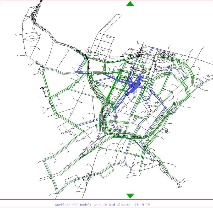
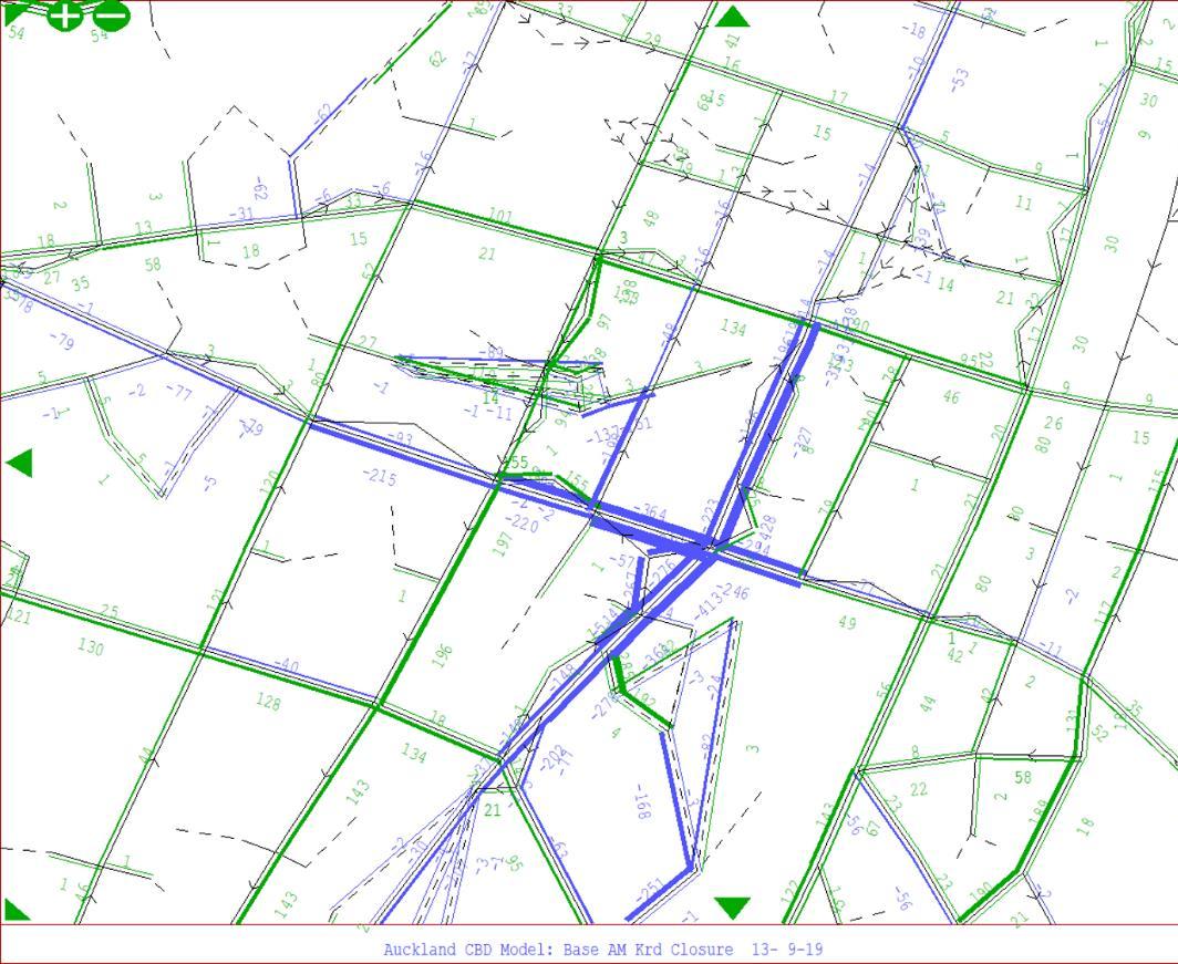
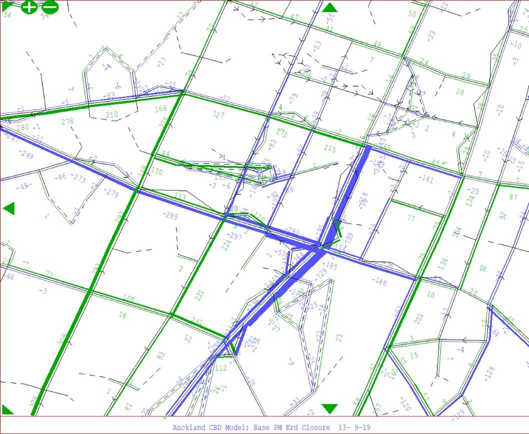
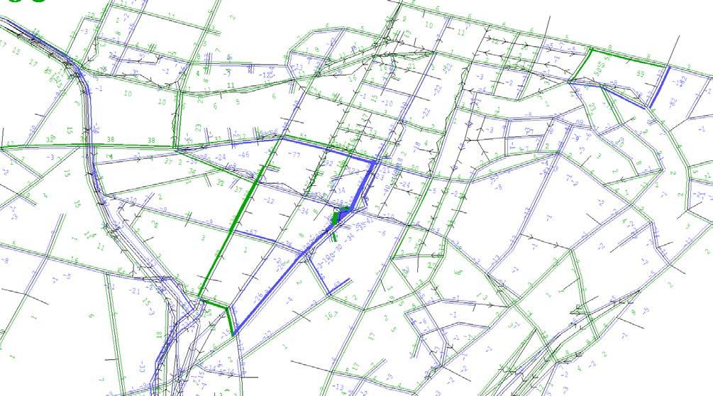
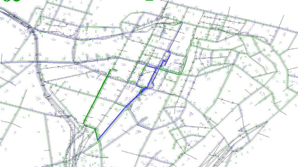
In the plots shown in Figure 3 to Figure 6, the green bands indicate the increases in traffic flows between the 2019 Reference Case scenario and the Wellesley Street Closure CRL Stage 4B & 5 scenarios, while the blue bands indicate decreases in traffic flows (band width proportional to the volume of change).
The flows displayed are what SATURN terms “demand” flows, which are the flows given by the assignment stage and correspond to the total demand independent of when the flow arrives. In congested networks, the “actual” flows are lower than the “demand” flows.
The proposed temporary traffic management is predicted to result in traffic flow changes primarily on Albert Street, Wellesley Street, Mayoral Drive and the immediate surrounding area.
The modelling results for morning peak show:
• a significant decrease in traffic flows along Albert Street and Mayoral Drive up to Vincent Street via the planned closed Wellesley intersection;
• a substantial reduction in traffic flows along the east -west aligned corridor of Wellesley Street, as anticipated;
• the traffic being re-routed to immediate surrounding routes such as Cook Street via Mayoral Drive and Victoria Street;
• an increase in traffic flows along Hobson Street reflects the major southbound movement
The modelling results for evening peak show:
• a reduction in Albert-Mayoral Street and Wellesley Street traffic flows similar to the morning peak
• a moderate increase in traffic flows along Nelson and Queen Streets which accommodates the traffic evading the closure;
• Fanshawe Street also experiences some increase in traffic flows as a result of the traffic flows dispersing into the Northern Motorway.
Figure 3 Demand Flow Difference (2019 Reference Case vs 4b&5 Utility Work Closure); Morning Peak
Figure 4 Demand Flow Difference (2019 Reference Case vs 4b&5 Utility Work Closure); Evening Peak
Figure 5 Demand Flow Difference - Area of Influence (2019 Reference Case vs 4b&5 Utility Work Closure); Morning Peak
Figure 6 Demand Flow Difference - Area of Influence (2019 Reference Case vs 4b&5 Utility Work Closure); Evening Peak
7.2.2. Journey Times
The proposed temporary traffic management is predicted to result in journey time changes due to closure of the Wellesley-Albert Street intersection. The results indicate that traffic flows on Victoria Street experience slight delays due to the re-routing of traffic away from the closed intersection. There is also a slight increase in journey times on the surrounding routes such as Hobson Street, Queen Street and Fanshawe Street because of the traffic rerouting.
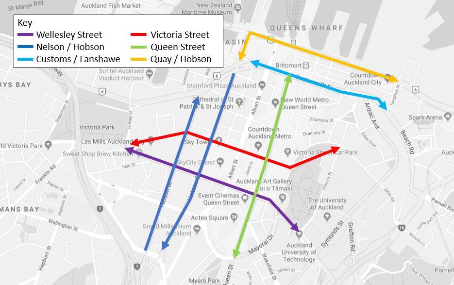
Specified routes have been assessed and are listed below:
• Wellesley Street (between Victoria Street and Princes Street)
• Victoria Street (between Wellesley Street and Princes Street)
• Nelson Street / Hobson Street (between Pitt Street and Fanshawe Street)
• Queen Street (between Mayoral Drive and Customs Street)
• Customs Street / Fanshawe Street (between Nelson Street and Tangihua Street)
• Quay Street / Lower Hobson Street (between Fanshawe Street / Hobson Street and Tangihua Street)
These routes are illustrated in Figure 7 below. The journey time routes are consistent with those specified routes that are used to monitor the traffic effects of CRL construction.
Table 3 and Table 4 present the modelled journey times for the routes assessed for both the Reference Case and temporary construction works. The comparative analysis suggests that the temporary works will have a relatively low impact (less than 3-minute change) to all the journey times assessed. Both the rerouting and delay caused by the temporary works do not seem to extend far enough to have any noteworthy change on the journey times routes specified in the consent conditions.
Figure 7 Journey Time Routes
Table 3 Journey Times (Morning Peak)
Table 4 Journey Times (Evening Peak)
7.3 Public Transport Effects
Due to the closure of the Wellesley Street - Albert Street intersection in stages 4B and 5, all bus routes that currently use Wellesley Street West (between Queen Street and Hobson Street) will need to be rerouted. Auckland Transport is planning and managing the bus diversions required during the intersection closure.
The closure of the intersection will affect mainly western bus routes, with a small number of northern, southern, eastern and central routes affected. The Outer Link and Skybus services are also affected. In general, the bus routes will be rerouted to use another east-west route such as Victoria Street West and Mayoral Drive/ Cook Street.
Figure 8 shows indicative bus diversion routes, noting that these are still subject to change. Bus stop locations are yet to be confirmed, but as can be seen on the diagram they will not be a great distance away from the current stops. Therefore, the inconvenience to bus patrons in terms of getting to a different stop will be small.
Key Section of Wellesley Street closed
Figure 8 Indicative bus diversion routes during closure of Wellesley Street West/ Albert Street intersection
The starting bus stop for bus route 18, which was previously relocated to the bus stop outside Sky Tower on the southern side of Victoria in Stages 1 -3 will be moved back to its original position. This is the bus stop on the southern side of Victoria Street West (between Albert Street and Elliott Street).
Wellesley Street is a key public transport corridor with many bus routes operating at high frequency within and outside the City Centre Area. Currently buses use Wellesley and Victoria Streets for the east-west movements and closure of the Wellesley-Albert Street intersection may have a significant effect on public transport reliability and mode-share. As a result, several bus routes need to be realigned to maintain the public transport patronage and reduce public inconvenience.
To understand the impact of the proposed closure on the bus routes, travel times for crucial bus routes that pass through or close to Wellesley Street have been extracted for the traffic management option and compared to the reference case. Figure 9 below shows the proposed realignment of bus routes as a result of the Wellesley Street intersection closure.
Table 5 and Table 6 summarise the comparative analysis between the proposed intersection closure and the Reference Case, as shown below for various routes. The comparative analysis suggests that the proposed closure will likely increase bus journey times (ranging between 0-7 minutes) for the 31 assessed bus routes. An average delay of between 5-7 minutes is anticipated for buses that previously used Wellesley Street Being one of the central bus corridors the re-alignment of the buses to the adjoining road network results in buses sharing the road space with other vehicles, which have also been displaced due to the Wellesley Street/ Albert Street intersection closure
Figure 9 CRL 2019 Stage 4B and 5 Bus Route Changes for Wellesley-Albert Intersection Closure
Table 5 Bus Journey Times (Morning Peak)
7.4 Pedestrian and Cyclist Effects
Access to properties and all pedestrian routes will be maintained on Albert Street (including the southern section of the Albert Street slip lane), Victoria Street West, Wellesley Street West, Mayoral Drive, Kingston Street and Durham Street. Pedestrian and cyclist effects will be limited to minor inconvenience due to reduced footpath widths and minor diversions being in place. The diversions that are implemented will still allow access to all properties.
The Stage 4 and 5 works may result in reduced/realigned foot traffic which could have an impact on businesses. These effects are addressed in the addendum to the Social Impact and Business Disruption Delivery Work Plan.
The ability for pedestrians to cross Albert Street from east to west (and vice versa) will be managed by signalised pedestrian crossings at the Wyndham Street/Albert Street intersection, Victoria Street West/Albert Street intersection, midblock of Albert Street (50m north of Wellesley Street West) and at the Wellesley Street West/Albert Street intersection. These crossings are located around 160m, 140m and 40m apart, respectively.
Due to the closure of the Wellesley Street West/ Albert Street intersection to traffic in stages 4B and 5, pedestrian crossing routes will be changed, however east-west pedestrian access will be maintained. The width of the pedestrian routes will be such that they will accommodate the crossing demand.
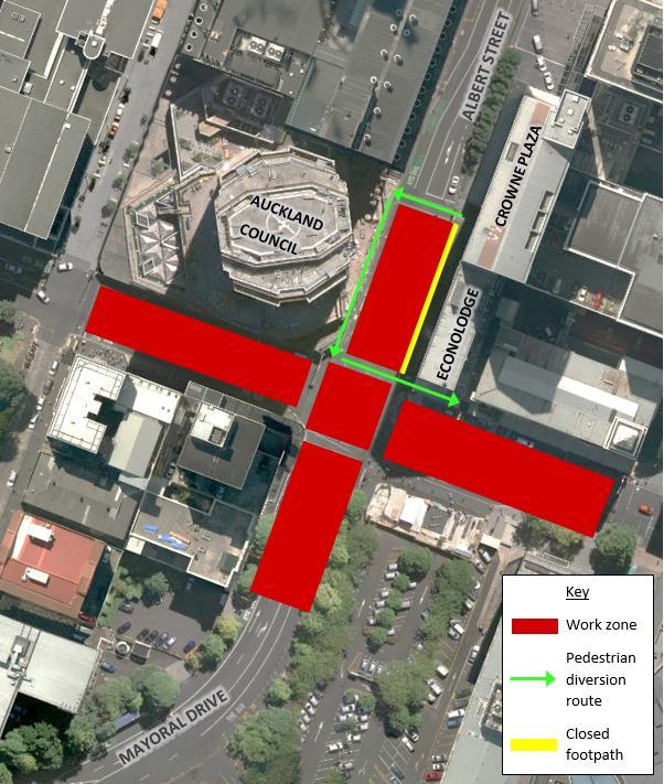
A small section of footpath between the Crowne Plaza and Econolodge on Albert Street will need to be closed. The location and construction of the D-wall for the station box structure has to occur directly below this section of footpath. The resulting footpath closure in this location cannot be avoided. However, pedestrians will be directed to cross over to the western side of Albert Street and are then able to use the crossing at the intersection of Albert Street and Wellesley Street to continue their journey down Wellesley Street West towards Queen Street. The diversion is depicted in Figure 10 The diversion equates to roughly a 60-80 m diversion for pedestrians. This effect of this is considered minor and acceptable.
While the southern section of the Albert Street Slip lane (off Durham Street) is closed to traffic, realigned pedestrian movements will continue to be provided to enable access to properties. Specific wayfinding signage will be provided as required.
While Kingston Street is closed to traffic, pedestrian routes will be provided to enable access to properties. Specific wayfinding signage will be provided as required.
The cycle boxes on Victoria Street West will be maintained during the works, and there will be no impact to the shared use environment on Elliot Street and Federal street (south of Victoria Street West) or the cycle lanes on Federal Street (north of Victoria Street West).
Figure 10 Pedestrian diversion route for the closure of footpath between Crowne Plaza and Econolodge
7.5 Construction Traffic
Construction truck numbers associated with the Stage 4 and 5 works are expected to be low (as outlined in section 6.3 of this TAP DWP addendum). The number of truck movements anticipated is not expected to worsen congestion on the surrounding road network.
7.6 Property Access
During the Stage 4 and 5 works, pedestrian and cyclist access to all properties on Albert Street, Victoria Street West, Kingston Street and Mayoral Drive will be maintained. Safe access will generally be maintained by providing a pedestrian route along the frontage of buildings where possible, or by providing a protected pedestrian passageway through the work zone. Wayfinding signage will be provided to guide pedestrians requiring access to properties.
During the closure of Kingston Street in stage 4A, pedestrian and cyclist access to properties (including emergency access) will be maintained and vehicle access to the garage in the building at 6-12 Kington Street will continue to be provided. All through traffic will be diverted along Federal Street and will be able to access Albert Street via Wyndham Street. The dedicated on-street Police parking zone for the District Court has already been relocated as part of earlier CRL works to a location further west on Kingston Street.
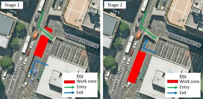
During the staged closure of the southern section of the Albert Street slip lane (between Durham Street West and Victoria Street), vehicle access to the adjoining Finance Plaza building and carpark will be disrupted. Discussions with the property owner, BEI Group Limited, and the main tenant, Wilson Parking, regarding access/parking arrangements and mitigation are being progressed outside of the TAP DWP process. Pedestrian access will continue to be provided to the adjoining properties.
The proposed mitigation to maintain access to the Finance Plaza car park will be to utilise the air bridge access from Albert Street to Level 4 of the parking building and to make minor adjustments to the internal operations to allow a one way flow of vehicles through the carpark. Exit onto Albert Street slip lane will be maintained throughout the works. This is indicated on the staging diagram shown below in Figure 11
Figure 11 Proposed Access Mitigation for Finance Plaza carpark
For the remainder of the businesses and residential properties on Durham Street West, the proposed mitigation will be to retain vehicle entry from Queen Street and reverse the entry from Albert Street to be exit only. This will provide the same level of access to all properties within Durham Street West as is currently the case.
To facilitate the safe exit of vehicles onto Albert Street and/ or Wyndham Street from the reversal of the Albert Street slip lane, traffic signals at the intersection of Albert Street and Wyndham Street will be modified to provide a green phase for these vehicles. Entry to Durham Street West from Queen Street will be via both left turn and right turn manoeuvres and, due to the expected increase in vehicles using this entry (especially in the AM peak), there will be manual traffic control present on site between 7am-10am to manage the conflict with pedestrians along Queen Street.
Refer to Figure 12 below for details of this proposed mitigation.
Existing vehicle access to the Albert Street service lane below Crowne Plaza (accessed off the southern leg of the Victoria Street West/Albert Street intersection) will be maintained. In stage 4B and 5 when the Wellesley Street West/Albert Street intersection is closed to traffic, vehicles using the service lane will be able to exit via a left turn onto Wellesley Street West.
Existing vehicle access to Crowne Plaza, the Atrium carpark, and the Sky City carpark will be maintained. In stage 4B and 5 when the Wellesley Street West/Albert Street intersection is closed to traffic, vehicles exiting Crowne Plaza and the Atrium carpark will turn right onto Albert Street, and
Figure 12 Proposed mitigation for Albert Street slip lane closure from Durham Street West
vehicles exiting the Sky City carpark will turn left onto Albert Street. Where needed, a traffic controller will be present at these accesses to manage conflict with pedestrians and construction activity.
Vehicle access to the Bledisloe House carpark (that part not being used for the CSA) will be maintained through the establishment of a one-way system, with entry off Mayoral Drive and exit onto Wellesley Street West. While the Albert Street/ Wellesley Street West intersection is open, a left-only exit will be permitted. During the closure of the intersection in stages 4B and 5, vehicles will only be able to exit via a right turn onto Wellesley Street West.
Vehicle access to the carpark located at 44-54 Wellesley Street West will be maintained throughout the closure of the Albert Street/Wellesley Street West intersection by providing local vehicle access through or around the work zone.
Vehicle accesses may be required to be closed for short periods of time. This will be minimised as much as practicable and when temporary closures are necessary, property owners and occupiers will be consulted with, in reasonable advance of the closure. During these periods, and where a closure is in effect for a period of between six and 72 hours, alternative car parking arrangements will be agreed with the owners/leaseholders of these spaces in advance of the closure occurring Mitigation will likely be to provide alternative parking in nearby public and private parking buildings that are located within a short distance of the work area. The details of this will be agreed through the consultation and engagement process outlined in Section 9 of this TAP DWP addendum and the Communication and Consultation Plan addendum for the Stage 4 and 5 works.
In the event an affected party unexpectedly finds their vehicle blocked in as a result of a temporary closure, the Link Alliance will (within reasonable limits) offer alternative transport such as a taxi, rental car, or other alternative, in accordance with CRL designation condition 25.3 (g).
7.7 Parking and Loading
7.7.1.
Stage 4A
The loading zone on the northern side of Victoria Street West (between Federal Street and Albert Street) will not be available for use. Loading zones on Federal Street are located in close proximity and can be used for the duration of the closure.
During the closure of Kingston Street, the loading zone on the southern side of Kingston Street (between Federal Street and Albert Street) will be unavailable for use. Three loading zones on Federal Street (between Kingston Street and Victoria Street West) are located in close proximity and can be used as an alternative. The police parking currently located on the southern side of Kingston Street (between Federal Street and Albert Street) is being relocated as part of the Aotea Stage 1 -3 utility relocation works.
7.7.2.
Stage 4B and 5
The loading zone on the northern side of Wellesley Street West (west of Albert Street) will be closed. Federal Street is a shared zone and can be used for loading from 0600 – 1100. In addition, a loading zone is located on Federal Street (south of Wellesley Street West). These will service the loading zone demand during the closure.
The loading zone on the northern side of Wellesley Street West (east of Albert Street) will be closed. The loading zone further down on Wellesley Street (on the corner of Elliott Street and Wellesley Street will be available for use. In addition, Elliott Street is a shared zone and can be used for loading from 0600 – 1100. These two alternatives will service the loading zone demand during the closure.
The loading zone on the southern side of Wellesley Street West is anticipated to be closed. In the event of this, the two options mentioned above (Elliott Street and corner of Elliott Street/Wellesley Street West) will be used as an alternative.
7.7.3. Paid on-street parking
In stage 4A, Kingston Street (between Federal Street and Albert Street) will be closed for 4 - 6 weeks. This will affect approximately 12 parks on Kingston Street which will be unavailable for use during that time. The closure of Kingston Street will take place over the Christmas break, in which the demand for parking in the City Centre including the adjacent District Court will be lower.
In stage 4B and 5, the work zones will not impact on any paid on-street parking.
8. Monitoring
No changes are required to Section of the Approved TAP DWP.
9. Consultation and Communication
The Communication and Consultation Plan (CCP) for the Stage 4 and 5 works sets out the procedures to advise affected parties and the general public of the proposed temporary traffic management measures Table 7 summarises the external communication requirements for the project. The property owners and occupiers listed are noted for early and specific consultation and agreement in regards to traffic, access and parking matters. Table 7 identifies those relevant to the Stage 4 and 5 utility relocation works.
Table 7 External Consultation Requirements
Stakeholder
Wilson Parking
BEI Group Limited
Temporary vehicle access restrictions and changes to carpark accessed off Albert Street southern slip lane (Finance Plaza)
Temporary vehicle access restrictions and changes to carpark accessed off Albert Street southern slip lane (Finance Plaza)
Discussions with Wilson Parking and building are being progressed to agree mitigation.
Building owner is in support of proposed mitigation to maintain access to and operation of the Finance Plaza car park.
Media Design School Temporary access restrictions Consulted with Media Design School on 4/09/2019 to understand their access requirements. Both pedestrian entrances will be maintained, as well as the loading bay at the rear on Durham Street West for deliveries.
Properties on Durham Street West and Durham Lane
Closure of the Southern section of the Albert Street slip lane will mean that vehicles can only enter Durham Street
Consultation will be undertaken prior to the proposed changes to
Auckland District Court –Ministry of Justice (65 Albert Street)
10 Kingston Street
Sky City
Crowne Plaza
Atrium Carpark
Skybus
Auckland Council
from Queen Street and exit via the northern section of the slip lane. the operation of Durham Street West.
Temporary access restrictions to Kingston Street
Consultation ongoing to understand access requirements.
Temporary vehicle access restrictions Consultation ongoing to understand access requirements.
Vehicle access limited to right in/left out to Carpark on Albert Street
Vehicle access limited to left in/right out
Vehicle access limited to left in/right out
Relocation of bus route through Wellesley Street West
Loss of parking for customers and staff at the Bledisloe House carpark due to the CSA.
Discussions between CRLL and Sky City have taken place.
Consultation with Crowne Plaza took place via a meeting, where access requirements were discussed.
Consultation ongoing to establish suitable mitigation.
Auckland Transport is managing the diversion of this service and the ongoing consultation and liaison with Skybus
Consultation has taken place with Auckland Council. City Rail Link Limited and Auckland Council have agreed on the occupation of the carpark during CRL construction
The general public and wider city centre community
Temporary changes to loading bays, pedestrian routes and increased truck movements.
Auckland Transport
Public transport users and operators, and taxi operators
Temporary changes to bus routes and bus stop locations, temporary closure of loading zones.
Temporary changes to bus stop locations
Taxis will be affected to the same extent as general traffic
Consultation to take place via the Aotea Community and Business Liaison Group (CBLG). Ongoing consultation to the wider community to be carried out via the CRL Project website and dropin sessions
The proposed works have been presented to Auckland Transport, who are progressing the changes required to the bus network and infrastructure.
Auckland Transport will lead on the communications to affected Public Transport users. Communication will be issued to taxi operators, freight companies and haulage association regarding the closure of Wellesley Street.
New Zealand Transport Agency
“One Network” consultation in accordance with CRL Condition 18
Emergency Services
Works will not impede emergency service access to properties
The proposed works have been presented to NZTA for comment. At this time no response has been received, however there is envisaged to be no impact to the State Highway network from the Stage 4 and 5 works.
Consultation occurred with all three emergency services and no
issues were raised. 2 weeks’ notice in advance of road closures will be given to emergency services.
Record of CLG, independent peer review and Auckland Council comments
CLG review comments
1.0 30/09/2019 5pm CLG Heart of the City What are the detour and diversion plans for the closures?
2.0 30/09/2019 5pm CLG Heart of the City Loading zone closures and access for businesses during these closures. Would there be space available within work sites for loading?
The TMPs will contain the proposed detour and diversion routes in consultation with Auckland Transport.
Access to the construction sites would be restricted to site vehicles only. However, options to use areas adjacent to work zones will be explored. Also to note that work zones would be uplifted as soon as practical to allow kerbside functions to resume.
3.0 30/09/2019 5pm CLG Heart of the City Suggested innovation was to look at having a central deliveries hub from where small vehicles could distribute goods.
4.0 30/09/2019 5pm CLG Heart of the City Are there any major changes to loading compared to Stages 1-3 works?
Although a valid idea, the scope of this is outside of the responsibility of the CRL project. Suggest that this is taken up with Auckland Transport.
Overall, no as the same areas are affected in Stages 4 and 5 as were in Stages 1-3. Additional loading zone options have been explored given the longer term nature of the Stages 4 and 5 works.
5.0 30/09/2019 5pm CLG Heart of the City Suggest that positive messaging be used when conveying the road closures/ VMS messaging and other communications will be developed in
6.0 30/09/2019 5pm CLG Heart of the City
7.0 30/09/2019 5pm CLG Heart of the City
restrictions via VMS and to see more use of Auckland Transport apps for distribution of information.
Would like to see footpath widths as wide as possible around work zones.
How is access to properties and bus routes affected by the closure of the Wellesley Street/ Albert Street intersection?
conjunction with Auckland Transport to target appropriate users with the correct messaging.
Footpath widths will be maximised where at all possible.
Discussions with affected property owners to determine impacts and agree mitigation is ongoing. Auckland Transport is leading on the bus diversion planning and implementation of this by late Feb 2020.
8.0 30/09/2019 5pm CLG Heart of the City
How will the closure of the Wellesley Street/ Albert Street intersection affect events in the City?
9.0 30/09/2019 5pm CLG Heart of the City
10.0 30/09/2019 5pm CLG Peter Young –Auckland Council
How will the long term Street Scape works affect the current provision of parking, loading zones and bus stops?
How will emergency access be maintained to the Council building on Albert Street as there had been issues earlier with egress from the building during an emergency?
Auckland Transport, who coordinates the traffic management for events, will take in account the CRL works in their planning.
The Street scape design works are still ongoing and Auckland Transport and Council are setting the requirements of this, not the Link Alliance.
Engagement with Fire and Emergency has highlighted escape routes and access to fire facilities must be maintained during the works. Further engagement with Auckland Council is ongoing to discuss emergency evacuation procedures and
11.0 30/09/2019 5pm CLG Peter Young –Auckland Council
Independent peer review comments
21
Section 7.3 The comparative analysis suggests that the proposed closure will likely increase bus journey times (ranging between 0-7 minutes) for the 31 assessed bus routes. An average delay of between 5-7 minutes is anticipated for buses that previously used Wellesley Street
11
Section 6.2 Stages 4B and 5 involve the closure of the Albert Street/ Wellesley Street intersection to traffic.
Traffic in the vicinity of the Wellesley Street West/ Albert Street intersection during the closure will be diverted.
Concerned with the timeframes for the occupation of the Bledisloe Car Park for the Construction Support Area. They require a 2 month notice.
The closure of Albert/Wellesley St intersection is a critical component of these works as Wellesley St is currently a main bus route (NX2, Outer Link and 82 routes amongst others).
The modelling analysis shows the general traffic effects are not substantial, however the impacts on buses are greater (up to 5-7 minutes for those routes using Wellesley Street – refer Table 6). There is some concern that while a proposed bus detour route has obviously been modelled, what happens if another bus detour route is eventually selected? Are the increases potentially larger? Buses are an important priority during construction. AT are still confirming the alternative routes. The DWP shows there are potential alternative routes.
These alternative routes may require localised priority measures to ensure services are not unduly delayed which the reviewer would support.
The closure of the Albert Street/ Wellesley Street intersection is not considered minor. Early communication of proposed network changes will be required, including emergency services and private passenger vehicles.
potential alternatives
Advised to discuss this with the Construction Manager, Matt Sinclair
AT is investigating measures to improve bus performance such as priority measures and bus queue jumps. This is being done in the background and AT will decide on the routes and measures that are ultimately used. However, these measures do not form part of this TAP DWP.
No Change to TAP DWP.
The Link Alliance is working with AT on both an Operational and Communication & Engagement basis. Opportunities to implement network wide messaging regarding the closure is being looked at, such as on arterial approaches to the City Centre. Messaging will commence early January, building up towards the closure in late March
Additionally, conversations with NZTA have investigated using their variable messaging systems on the State Highway.
No Change to TAP DWP.
Auckland Council review comments
20 Section 7.3
12
Section 6.2
25
Section 7.4
Indicative suggestions of where relocated bus stops will be should be provided.
12 Section 6.2
Stages 4B and 5 have comprehensive diversions descriptions. However, these should be accompanied by diagrams to make routes clearer and to make it easier to determine if there are any issues.
The proposed closure of Wellesley Street West and Mayoral Drive will have a minor effect on cyclist movements, due to these streets not having any existing cycling facilities. Cyclist movements (minimal) will be transferred to the shared use environments of Federal Street and Elliot Street, leading to an increase of cyclist traffic on these streets, however this effect is deemed minor. Nevertheless, this effect would need to be monitored and if considered significant, is to be addressed via an appropriate and approved traffic management plan.
Section 6.2 outlines that the works will occupy the bulk of the footpath, with a minimum width of 1.5m maintained. NZTA’s CoPTTM requires a minimum width of 2m to be maintained. This is to ensure access for all pedestrians is maintained (pedestrians on foot, mobility scooters, wheel chairs and pushing a pram).
An indicative diagram and explanation of the bus diversion routes and bus stop has been added. Note that this is subject to change TAP DWP updated.
A diagram of the indicative vehicle diversion route has been added. Note: this is subject to change. TAP DWP updated.
Noted. Should the volumes of cyclists increase significantly on Federal Street and Elliot Street due to the closure of Wellesley Street, specific mitigation will be investigated to address this and implemented where required. These changes will be captured as updates to the TAPDWP under the annual review, or through the material change process if deemed as such.
No Change to TAP DWP proposed at this stage.
CRL designation condition 27 (j) states: Providing footpaths of at least 1.5m in width along either side of Albert Street.
Excluding Albert Street, the Alliance understands that a greater footpath width will enable better access, however there may be pinch points at which only 1.5m is available. In all cases, the Alliance will endeavour to provide the greatest width of footpath possible. No Change to TAP DWP.
24 Section 7.4 The section of footpath between the Crowne Plaza and Econolodge will be closed with an acceptable alternative provided by an approximately 60-80m diversion on the adjacent footpath. This is deemed minor, however needs to be accompanied by plans/ mark-ups of the proposed pedestrian diversions and proposed safety measures
24 Section 7.4
Details/diagrams of the pedestrian diversions should be provided.
31 Appendix No Temporary Traffic Management Plans are included in Appendix A. These will need to be developed and implemented for all transportation modes.
A diagram of the pedestrian diversion route has been added. Note: this is subject to change.
TAP DWP updated
The only pedestrian diversion in these works is for the footpath between Crowne Plaza and Econolodge. A diagram for this has been provided. No Change to TAP DWP.
TMPs will not be included within this report, due to ongoing evolution of these following conversations with
stakeholders and AT. Details in this report regarding access, diversions and traffic management will be reflected in TMPs submitted to AT.
No Change to TAP DWP.
Project: Albert Street Utility Relocation and Canopy Removal
Title: Transport Access and Parking Delivery Work Plan
The drawings, information and data recorded in this document (the information) are the property of Flow Transportation Specialists Ltd. This document and the information are solely for the use of the authorised recipient and this document may not be used, copied or reproduced in whole or part for any purpose other than that for which it was supplied by Flow Transportation Specialists Ltd. Flow Transportation Specialists Ltd makes no representation, undertakes no duty and accepts no responsibility to any third party who may use or rely upon this document or the information.
Albert Street Utility Relocation and Canopy Removal Transport Access and
1 INTRODUCTION
Flow Transportation Specialists Ltd (Flow) has been commissioned by the requiring authority to develop a Transport Access and Parking Delivery Work Plan (this DWP) for the Albert Street Utility Relocation and Canopy Removal Project (the Project).
The Project involves early works in advance of the main construction of the City Rail Link (CRL) Aotea Station (Construction Contract C3). The early works will be undertaken under the CRL Construction Contracts C2.1 and C2.2 and involve the removal of building canopies and the relocation of underground utilities along the western side of Albert Street from Wellesley Street West to Victoria Street West. The canopies will be reinstated following completion of the Aotea Station construction, under Contract C3.
The location and extent of works are shown in Figure 1 below. The entire works are located within the CRL Designation 1714 (designation 1).
Figure 1: Location and approximate extent of the proposed Albert Street Utility Relocation and Canopy Removal
2 PURPOSE AND OBJECTIVES OF DELIVERY WORK PLAN
The purpose of this DWP is to describe the measures that will be taken to avoid, remedy and mitigate the adverse effects of the Project’s construction on transport, parking and property access. Specifically, this DWP meets the objectives of CRL designation Conditions 25.1 and 25.2, by addressing the transport, parking and property access issues identified in Conditions 25.3, 27.1 and 27.2.
This DWP manages the transport, access and parking implication for the Project for works within the designation. It is considered that the measures outlined in this DWP meet both the requirements of the relevant designation conditions listed in Table 1 below.
3 CRL DESIGNATION CONDITION REQUIREMENTS
The following CRL designation conditions are relevant to this DWP:
Table 1: CRL Designation Condition Requirements
Number
18 “One Network” Consultation
18.1 The Requiring Authority and its contractor shall work collaboratively with the New Zealand Transport Agency (NZTA) during the preparation of the Traffic, Access and Parking DWP (Conditions 25, 27, 28, 29, and 30) in relation to confirming the management of adverse transport effects on the road network. A record of this consultation and outcomes shall be included in the Traffic, Access and Parking DWP. The Requiring Authority shall consult with the NZTA throughout the duration of construction on any changes or updates to the Traffic, Access and Parking DWP which relate to the management of the road network.
20 CEMP Requirements
20.1 In order to give effect to the objective in Condition 19.1, the CEMP must provide for the following:
(d) A Travel Management Plan for each construction site outlining onsite car parking management and methods for encouraging travel to the site using forms of transport other than private vehicle to assist in mitigating localised traffic effects Sections 4.4 and 4.5
21 CEMP Construction Works Requirements
21.1 In order to give effect to the objective in Condition 19.1, the CEMP shall include the following details and requirements in relation to all areas within the surface designation footprint where construction works are to occur, and / or where materials and construction machinery are to be used or stored:
(a) Where access points are to be located and procedures for managing construction vehicle ingress and egress to construction support and storage areas; Section 6.3
25 General Transport, Access and Parking
25.1 A Transport, Access and Parking DWP shall be prepared to manage the adverse effects of construction of the City Rail Link, or any part of it, on the transport network. All sections
Table 1: CRL Designation Condition Requirements
25.2 The objective of the Transport, Access and Parking DWP is to so far as is reasonably practicable, avoid, remedy or mitigate the adverse effects of construction on transport, parking and property access. This is to be achieved by:
(a) Managing the road transport network for the duration of construction by adopting the best practicable option to manage congestion; All sections
(b) Maintaining pedestrian access to private property at all times; and
(c) Providing on-going vehicle access to private property to the greatest extent possible.
25.3 To achieve the above objective, the following shall be included in the Transport, Access and Parking DWP:
(a) The road routes which are to be used by construction related vehicles, particularly trucks to transport construction related materials, equipment, spoil, including how the use of these routes by these vehicles will be managed to mitigate congestion, and to the greatest extent possible, avoid adverse effects on residential zoned land and education facilities;
(b) Transport route options for the movement of construction vehicles carrying spoil, bulk construction materials or machinery shall be identified and details provided as to why these routes are considered appropriate routes. In determining appropriate routes, construction vehicles carrying spoil, bulk construction materials or machinery shall as far as practicably possible only use roads that:
Section 7.6
Section 7.6
Section 6.3 and
Section 6.3 and
(i) Form part of the regional arterial network; Section 6.3 and Section 7.5
(ii) Are overweight / over dimensioned routes;
(iii) Or other routes (specified below) where no other practical option is available.
Section 6.3 and Section 7.5
Section 6.3 and Section 7.5
Table 1: CRL Designation Condition Requirements
Number Condition
(c) For the purposes of this condition the following routes (that at the time this designation was confirmed were not part of the regional arterial network and / or overweight / over dimensioned) shall be used where practicable for the movement of construction vehicles carrying spoil, bulk construction materials or machinery:
(i) Ngahura Road, for trucks heading to/from Eden Terrace construction site; Not applicable
(ii) Dundonald Street and Basque Road, for trucks heading to/from the Newton Station construction sites; Not applicable
(iii) Pitt Street (between Hobson Street and Hopetoun Street), Beresford Square, Mercury Lane, Canada Street and Upper Queen Street (between Canada Street and Karangahape Road), for trucks heading to/from Karangahape Station construction sites;
(iv) Wellesley Street (between Nelson Street and east of Albert Street), Cook Street (between Mayoral Drive and Hobson Street) and Mayoral Drive (between Wellesley Street and Cook Street) for trucks heading to/from Aotea Station construction sites;
Not applicable
Section 6.3 and
Section 7.5
(v) Nelson Street (north of Wellesley Street), Hobson Street (north of Cook Street) and Lower Albert Street, for trucks heading to/from the Albert Street and Downtown construction sites. Not applicable
(d) Where other routes are necessary (other than those routes identified above), the Transport, Access and Parking DWP shall identify any residential zoned land and education facilities and shall provide details on how adverse effects from these vehicle movements are to be mitigated through such measures as:
Not applicable
(i) Communication and consultation (in accordance with Condition 15 of this designation) with these properties in advance of the vehicle movements occurring; Not applicable
(ii) Restricting vehicle movements on Monday to Friday to between 9.30am and 4pm, and on Saturday to between 9am and 2pm. Not applicable
Table 1: CRL Designation Condition Requirements
(e) Proposed temporary road lane reductions and / or closures, alternative routes and temporary detours, including how these have been selected and will be managed to mitigate congestion as far as practicably possible and how advance notice will be provided;
(f) How disruption to the use of private property will be mitigated through:
(i) Ensuring pedestrian and cycle access to private property is retained at all times;
(ii) Providing vehicle access to private property as far as practicably possible at all times, except for temporary closures where landowners and occupiers have been communicated and consulted with in reasonable advance of the closure; and
(iii) How the loss of any private car parking will be mitigated through alternative car parking arrangements.
(g) Where an affected party unexpectedly finds their vehicle blocked in as a result of a temporary closure, the Requiring Authority shall (within reasonable limits) offer alternative transport such as a taxi, rental car, or other alternative.
Section 6.2
Section 7.6
Section 7.6
Section 7.6
Section 7.6
Note: For the purposes of designation Conditions 25, 27, 28, 29 and 30 “temporary closure” is defined as the following: Noted
(i) In place for less than six hours, the Requiring Authority shall communicate and consult on the closure at least 24 hours in advance, but is not required to offer or provide alternative parking arrangements, though it may choose to offer this on a case by case basis in consultation with the affected party; and Noted
(ii) In place for between six and 72 hours, the Requiring Authority shall communicate and consult on the closure at least 72 hours in advance, and will offer and provide where agreed with the affected party alternative parking arrangements. The alternative parking arrangement should be as close to the site affected as is reasonably practicable.
(h) How disruption to use of the road network will be mitigated for emergency services, public transport, bus users, taxi operators, freight and other related vehicles, pedestrians and cyclists through:
(i) Prioritising, as far as practicably possible, pedestrian and public transport at intersections where construction works are occurring;
Noted
Section 6.1
Table 1: CRL Designation Condition Requirements
Number Condition
(ii) Relocating bus stops and taxi stands to locations which, as far as practicably possible, minimise disruption; and Not applicable
(iii) Identifying alternate heavy haul routes where these are affected by construction works. Not applicable
(i) Cross references to the specific sections in the Communication and Consultation Plan that detail how emergency services, landowners, occupiers, public transport users, bus and taxi operators, and the general public are to be consulted with in relation to the management of the adverse effects on the transport network. Section 9
(j) The alternative (to road) transport options that are available (including the option of rail use at the main construction site adjacent the North Auckland Rail Line) and that have been considered and assessed for the transportation of spoil. This will include as applicable: Not applicable
(i) Benefits that could be provided by alternative options; Not applicable
(ii) Potential adverse effects associated with alternative options; Not applicable
(iii) Where an alternative option is proposed, methods for managing potential adverse effects; and Not applicable
(iv) Reasons for either adopting or not adopting alternative transport options. Not applicable
26.1 To achieve the objective of Condition 25.2(a), the Requiring Authority will undertake monitoring of the transport network and implement additional mitigation measures as required to manage congestion to achieve the best practicable option.
26.2 The purpose of the monitoring is to monitor congestion on the transport network by measuring average delays for traffic travelling along specified routes. The evaluation times will be:
(a) The average travel times over the weekday two hour morning peak period; and
(b) The average travel times over the weekday two hour evening peak period; and
(c) The average weekday inter-peak travel times between 9am to noon, noon to 2pm and 2 to 4pm.
Section 8
Section 8
Section 8
Section 8
26 Monitoring of Transport Network Congestion
Table 1: CRL Designation Condition Requirements
26.3 The Requiring Authority shall carry out continuous monitoring for the duration that construction of the City Rail Link is occurring. The intention is that this monitoring is to be continuous, although it is acknowledged that there may be occasional malfunctions. Section 8
26.4 If a congestion incident occurs (such as an accident), the monitoring during the affected period will be considered unrepresentative.
Section 8
26.5 Monitoring shall commence six months prior to construction of the City Rail Link to establish a baseline of existing transport congestion. Section 8
26.6 The monitoring will establish whether the City Rail Link construction works have increased traffic delays as follows:
(a) Either by more than 10 minutes (from the monitoring previously undertaken in accordance with this condition)
(b) Or if the travel times are more than three minutes or 30% greater than the forecast modelled increases along that route (according to the most recent traffic model test of that scenario, undertaken prior to the start of construction. The modelled time is to be based on the Auckland City Centre SATURN traffic model or a different traffic model approved by the Requiring Authority).
(c) The 30% above shall only apply for an increase predicted to be over four minutes.
26.7 If the travel times exceed the above criteria on any one of the specified routes, then additional mitigation shall be implemented by the Requiring Authority in its role as the Road Controlling Authority (under its statutory obligation). The additional mitigation could include but is not limited to advertising alternative routes, removing on street car parking or implementing operational measures, such as lane reconfigurations or signal phasing, to increase capacity on the surrounding network where reasonably possible at that time.
26.8 The purpose of additional mitigation measures is to mitigate the increases in traffic delays, reducing these to below the levels identified in Condition 26.6 as far as is reasonably achievable.
26.9 For the purposes of this condition, the following are the specified routes:
Section 8
Section 8
Section 8
Section 8
Section 8
Table 1: CRL Designation Condition Requirements
Number
(a) Wellesley Street (between Victoria Street and Princes Street) Section 8
(b) Victoria Street (between Wellesley Street and Princes Street) Section 8
(c) Customs Street/Fanshawe Street (between Nelson Street and Tangihua Street) Not applicable
(d) Quay Street/Lower Hobson Street (between Fanshawe Street/Hobson Street and Tangihua Street) Not applicable
(e) Nelson Street/Hobson Street (between Pitt Street and Fanshawe Street) Not applicable
(f) Queen Street (between Mayoral Drive and Customs Street) Not applicable
(g) New North Road/Symonds Street (between Dominion Road and Newton Road) Not applicable
(h) Mount Eden Road (between Normanby Road and Symonds Street) Not applicable
(i) Khyber Pass Road between the southern motorway ramps and Symonds Street if this route is to be used by construction related trucks Not applicable
(j) Newton Road between the northwestern motorway ramps and Symonds Street Not applicable
26.10 The specified routes shall exclude whichever east-west route has its intersection with Albert Street closed at the time of the surveys. Not applicable
27 Transport and Property Access: Specific Requirements (Britomart to Mayoral Drive)
27.1 To achieve the objective in Condition 25, the following measures shall be implemented:
(a) A vehicle access lane at least 3m wide shall be provided along the eastern side of Albert Street between Customs Street and Victoria Street to provide access to properties (except that while the Albert Street/Victoria Street intersection is closed, this access lane is only to be provided between Customs Street and Durham Street); Not applicable
(b) A vehicle access lane at least 3m wide shall be provided along the western side of Albert Street between Customs Street and Victoria Street to provide access to properties, except that: Not applicable
Table 1: CRL Designation Condition Requirements
Number
(i) While the Albert Street/Customs Street intersection is closed, this access lane is only to be provided between Victoria Street and Wolfe Street; and Not applicable
(ii) While the Albert Street/Victoria Street intersection is closed, this access lane is only to be provided between Kingston Street and Customs Street. Not applicable
(c) The east-west / west-east connection (two fully operational traffic lanes in each direction) is to be maintained in each direction at two of the Customs Street, Victoria Street and Wellesley Street intersections with Albert Street during the period when the third of those intersections is otherwise fully closed;
(d) The left turn movement from Customs Street (from the east) into Albert Street, and the left turn from Customs Street (from the west) into Albert Street, shall be retained while the Albert Street / Customs Street intersection is fully closed;
Not applicable
Not applicable
(e) The left turn from Durham Street into Queen Street shall be reopened while the Albert Street/Victoria Street intersection is fully closed; Not applicable
(f) Two way access shall be provided on the single service lane along the western side of Albert Street between 87 Albert Street and Kingston Street while the Albert Street/Victoria Street intersection is fully closed;
(g) Vehicular access into and egress from:
Not applicable
(i) Mills Lane to and from either Albert Street or Swanson Street; and Not applicable
(ii) The Stamford Plaza Auckland main entrance and forecourt area is to be provided at all times and for the avoidance of doubt cannot be temporarily closed during construction. Not applicable
(h) Providing pedestrian and cycle access to private property at all times;
(i) Providing footpaths of at least 1.5m in width along either side of Albert Street;
Section 7.6
Section 6.2
Table 1: CRL Designation Condition Requirements
(j) At a minimum two safe crossing passageways (which are “fully accessible” with a minimum width of 1.5m wide and well lit, need to be provided in the vicinity of Swanson Street and Wyndham Street, in addition to pedestrian crossings at the intersections of Victoria Street and Customs Street; and
Section 6.2
(k) Ensuring that construction traffic does not use Swanson Street, Wolf Street or Federal Street north of Swanson Street; Not applicable
27.2 The Traffic, Access and Parking DWP shall demonstrate how these measures will be implemented and shall also include the following:
(a) How construction works will be undertaken to mitigate congestion on Albert Street, Wellesley Street, Victoria Street, Customs Street, and Quay Street including retaining east-west traffic movements across Albert Street on Customs Street, Victoria Street and Wellesley Street;
(b) The timing and sequencing of temporary road lane reductions and / or closures, and the alternative routes and temporary detours to be used, including:
(i) How these have been selected and will be managed to, where practicable, mitigate congestion on the surrounding road network;
Section 6.2
Section 6.2
6.2
(ii) How the Albert Street/Wyndham Street intersection will be reopened as soon as practically possible; Not applicable
(c) How disruption to the use of private property located immediately adjacent the designation with access onto Galway Street, Tyler Street, Queen Elizabeth Square, Customs Street, Albert Street, Victoria Street and Wellesley Street will be mitigated through:
(i) Providing vehicle access to private property as practicably possible at all times;
(ii) Retaining local vehicle access to properties located along Albert Street (which may include only left in, left out access);
7.6
7.6
(iii) Retaining access for loading and unloading of goods located along the service lane on the eastern side of Albert Street, between Victoria Street and Wellesley Street; and; Not applicable
(iv) Providing an on street loading bay on Customs Street, Lower Albert Street or Lower Queen Street to provide servicing to 21 Queen Street if access during construction cannot be provided to the existing loading bay area for 21 Queen Street, accessed from Lower Albert Street; Not applicable
(d) How disruption to the use of the local road network will be mitigated for private bus users, pedestrians and cyclists through:
(i) Providing, where practicable, for the continued operation of private bus operators from hotels and other pick up / drop off locations in the city centre area (cross references to the Communication and Consultation Plan for consulting with private bus operators shall be included in the CEMP and Traffic, Access and Parking DWP); and
(ii) Retaining pedestrian and cycle access through Lower Queen Street and / or Queen Elizabeth Square to provide access to and from the Ferry terminal and Customs Street; and Not applicable
(e) How disruption to pedestrians and cyclists requiring the ability to cross from east to west (and vice versa) across Albert Street between Victoria Street and Customs Street can be mitigated through providing, where practicable, safe pedestrian and cyclist passageways across the construction works on Albert Street.
Not applicable
4 PROJECT WORKS
4.1 Introduction
The CRL project comprises the construction, operation and maintenance of a 3.4 km underground passenger railway, running between Britomart Station and the North Auckland Rail Line (NAL) in the vicinity of Mt Eden Station.
The works relating to this DWP constitute part of the enabling work for CRL, including the relocation of existing utilities and the removal of existing building canopies. Both components of the work will generally take place on Albert Street, between Wellesley Street West and Victoria Street West.
4.2 General Project Works
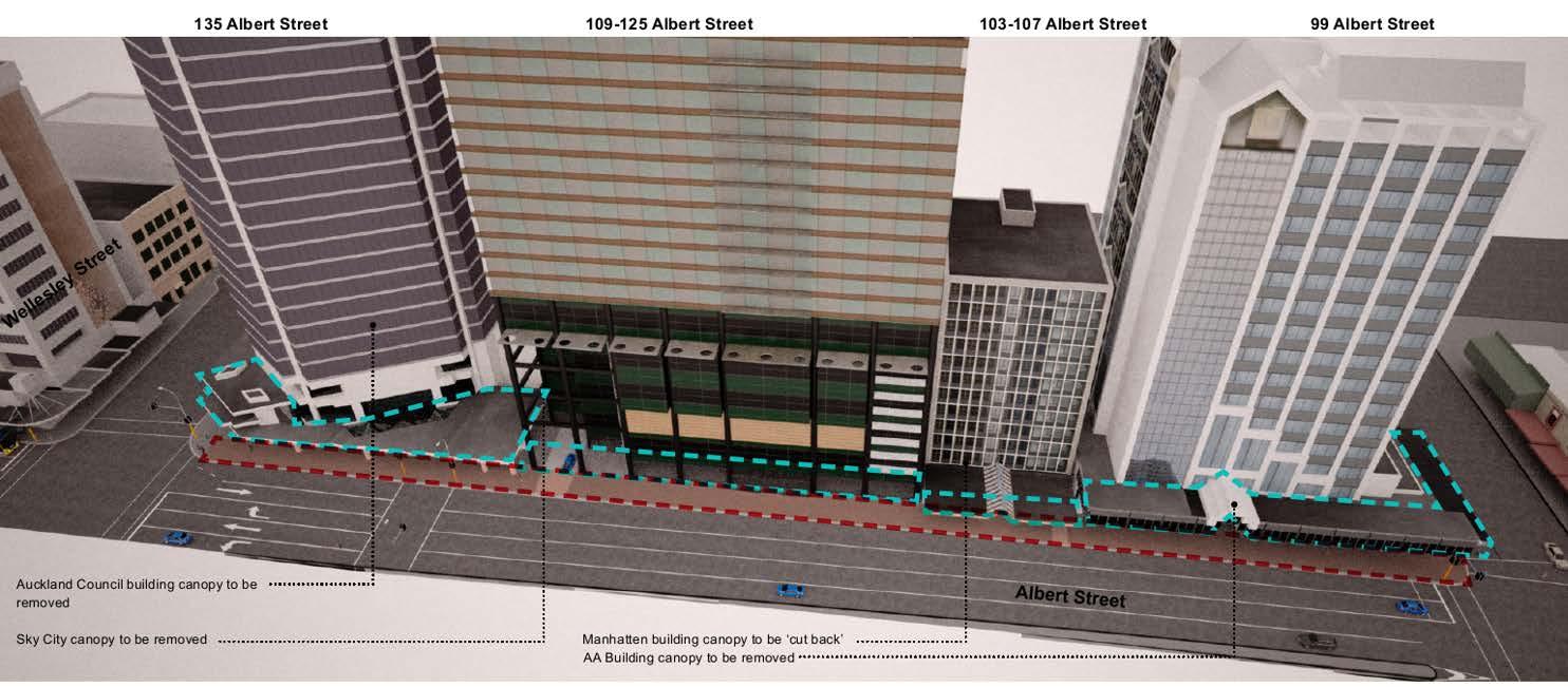
The Project proposes to relocate existing utilities and to remove existing building canopies on the western side of Albert Street, between Victoria Street West and Wellesley Street West. The works will be completed in sections, as documented below:
Removal of the existing building canopy at 99 Albert Street (the AA Centre)
Removal of the existing building canopy at 129-135 Albert Street (the Auckland Council building)
Removal of the existing building canopy at 101-107 Albert Street (the Manhatten Apartments)
Removal of the existing building canopy at 109-125 Albert Street (the Sky City Grand)
Relocation of existing utilities beneath the footpath on the west side of Albert Street (between Wellesley Street West and Victoria Street West) and beneath a short length of the footpath on the south side of Victoria Street West.
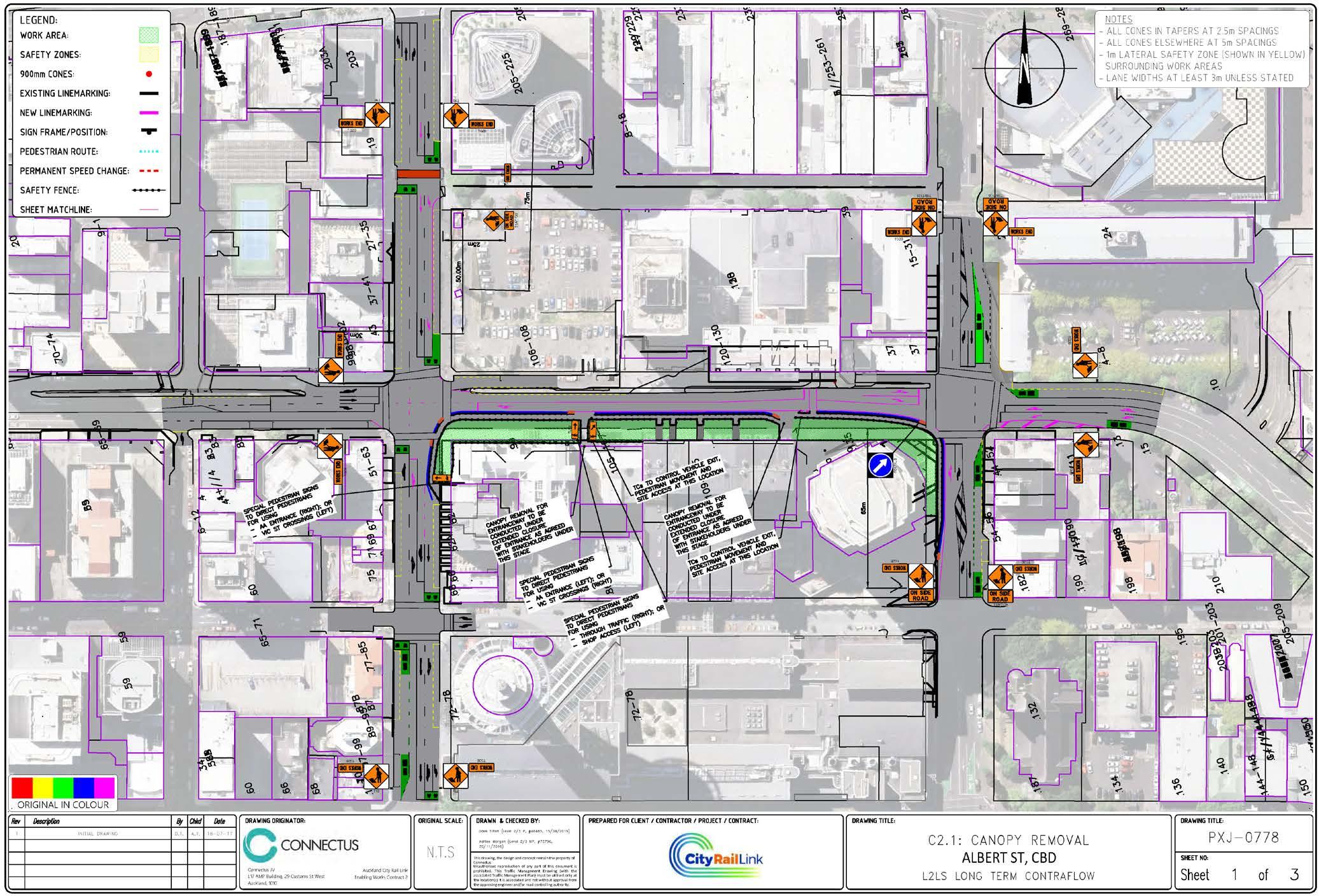
In general, a consistent temporary traffic management plan will be applied throughout the Project This plan is illustrated in Figure 2 to Figure 4 overleaf.
Figure 2: Albert Street Temporary Traffic Management
Figure 3: Albert Street Temporary Traffic Management – Victoria Street West Detail
Figure 4: Albert Street Temporary Traffic Management – Wellesley Street West Detail
In total, the works will take place over an approximately 15 month programme, commencing January 2018
4.3 Hours of Operation
Works will generally be undertaken between 7:00 am and 7:00 pm Monday to Saturday
4.4 Construction Workforce
The total Project workforce will vary through the work stages, but may peak at approximately 40 to 60 staff Additional subcontractor workforce such as traffic management and utilities staff will attend the site intermittently.
No workforce parking will be provided at the site, and workers will need to either park within public parking buildings or travel via other modes. Project vehicle access will be restricted to plant and material delivery, spoil removal and service vehicles.
4.5 Work Travel Demand Management
It is expected that the traffic effects of the workforce travel will be minimised through car sharing, use of public transport or staff shuttles. The Project workforce will be provided with public transport travel information, and encouraged to car pool if they choose to drive and use nearby public car parks.
The size of the workforce, relative to the main CRL construction workforce, is expected to be relatively small.
5 EXISTING CONDITIONS
5.1 General
Albert Street, Victoria Street West and Wellesley Street West all currently have temporary lane restrictions due the CRL enabling works. Of these enabling works, the Albert Street Stormwater works reduce both Victoria Street West and Wellesley Street West to a single lane of traffic in each direction at Albert Street. These works are anticipated to be completed in December 2017.
Further north on Albert Street, the CRL cut and cover works will continue to restrict traffic on Albert Street.
Albert Street is classified as a local road within the Auckland Unitary Plan (AUP). Prior to the CRL enabling works it carried approximately 11,500 daily vehicles, although this is expected to now be significantly reduced. Approximately 8% of Albert Street’s traffic are heavy commercial vehicles (HCVs), with much of this due to bus services. The route is strategically significant for public transport services, with Albert Street bus services part of Auckland Transport’s Frequent Service Network. This role has diminished with the CRL enabling works however, with no bus services on Albert Street between Victoria Street and Customs Street.
The following figures illustrate the existing lane configuration on Albert Street, between Victoria Street West and Wellesley Street West.
At the Victoria Street West intersection:
Area closed to traffic NB traffic lane (left turn at Victoria Street)
traffic lane (through at Victoria Street)
traffic lane
Midblock:
At the Wellesley Street West intersection: NB bus lane
traffic lane
SB traffic lane (right turn at Wellesley Street) SB traffic lane (through at Wellesley Street)
SB traffic lane (left turn at Wellesley Street)
It is expected that on completion of the Albert Street Stormwater works in late 2017, the northbound lane on Albert Street at the Victoria Street West intersection that is currently closed to traffic (shaded grey above) will reopen as a separate left turn lane.
The Albert Street bus lanes operate at all times On street parking is prohibited on this section of Albert Street.
Both Victoria Street West and Wellesley Street West are classified as Arterial Roads within the AUP, and carry 24,100 and 15,000 daily vehicles, respectively. Both streets are currently restricted to a single through lane at Albert Street, due to the CRL Albert Street Stormwater works. On completion of the CRL Albert Street Stormwater works, both streets will generally revert to their pre CRL works
layouts illustrated in Figure 5 and Figure 6 below (albeit with an additional westbound lane on Wellesley Street West, to provide separate left turn and bus-only through lanes). Note that the Albert Street lane configurations in these aerial photos have since changed to those shown above.
Figure 5: Victoria Street West at Albert Street
Figure 6: Wellesley Street West at Albert Street
Currently, bus services from Pt Chevalier and West Auckland (via both the Northwestern Motorway and Great North Road) operate on the section of Albert Street between Wellesley Street West and Victoria Street West (northbound only), before turning left into Victoria Street West, then left again into Hobson Street These services will be relocated off Albert Street shortly before the Project commences. We understand that the final routing of these services is yet to be confirmed, but the shift will result in the existing northbound bus stops and bus lane on Albert Street being redundant.
The above changes in bus services will be in place prior to the start of the Project works and will effectively form a new base case. The effects of this bus service shift are not considered as part of this DWP.
5.2 Walking and Cycling Facilities
Albert Street, Wellesley Street West and Victoria Street West all currently have footpaths on both sides. The western footpath on Albert Street in particular (that directly affected by the works) currently serves four functions:
Access function: Providing access to existing properties that front this section of Albert Street
Through function: Providing a through route for pedestrians between other properties, public transport facilities, parking areas and other destinations
Public transport function: Providing access to, and waiting space for, existing bus stops on Albert Street. This function will cease once bus services have been removed from Albert Street
Place function: Providing a space for pedestrians to linger and interact; it is thought that there is very little such function on this section of Albert Street, as with the exception of a small lunch bar with two small tables on the footpath beneath the AA Centre, there is no activation or reason for pedestrians to linger here.
Signalised pedestrian crossings are provided across all legs of the Albert Street intersections with Wellesley Street West and Victoria Street West. The latter operates with a ‘Barnes Dance’ type pedestrian phase, while the former operates separate pedestrian phases. A signalised midblock pedestrian crossing operates on Albert Street, approximately 50 m north of Wellesley Street West.
There are few dedicated cycling facilities in the area. Facilities are limited to cycle advance stop boxes on the Victoria Street approaches to Albert Street.
6 PROPOSED TRAFFIC MANAGEMENT
6.1
Philosophy
This DWP has been developed in general accordance with the traffic management approach put forward in the CRL designation conditions, as well as with Auckland Transport’s Code of Practice (ATCoP) and the Transport Agency’s Code of Practice for Temporary Traffic Management (CoPTTM).
In practical terms this means providing for the connectivity and access described in the designation conditions wherever and whenever possible and in particular for main road movements. Additional
turn bans or changes to connectivity or access have been restricted to those imposed by safe operational practice, and geometric or spatial constraints for traffic management.
The modal priorities adopted by this DWP are:
1. Active transport
2. Public transport
3. Freight, service vehicles, couriers and taxis
4. Private vehicles (including construction traffic).
Within CoPTTM, Albert Street, Wellesley Street West and Victoria Street West are classified as a Level 2LS (low speed) roads 1. The traffic management measures proposed in this DWP have been developed accordingly.
The below traffic management methods have been developed to be commensurate in size and scale to the construction activities proposed and their expected effects on the transport network.
6.2 General Traffic Management
The works will in general require the occupation of the existing footpath and two traffic lanes on the west side of Albert Street, between Victoria Street West and Wellesley Street West. The works will maintain the existing single traffic lane in each direction on Albert Street. However, the existing, short, three lane, southbound approach to Wellesley Street West will be reduced to two short lanes (with left turning and through traffic sharing a single lane).
Prior to the works, all existing bus services on Albert Street will be shifted elsewhere and as such, the existing northbound bus lane and bus stop lane on Albert Street will be redundant. The occupation of the northbound bus lane will as a result have no effect on bus services.
The removal of the building canopy from the AA Centre will require a short section of works to extend onto Victoria Street West. These works will result in the existing two westbound through lanes on Victoria Street West being reduced to one through lane.
Similarly, the removal of the building canopy from the Auckland Council building will require a short section of works to extend onto Wellesley Street West. These works will result in the existing separate eastbound left turn and through lanes on Wellesley Street West being combined into a single, shared lane.
It is expected that each of the above lane closures will be in place for the duration of the works.
During all stages of the works, all existing traffic movements between public streets will continue to be available.
Pedestrian movements on Albert Street, Wellesley Street West and Victoria Street West will continue to be provided, with at least 1.5 m footpaths provided in accordance with CRL Designation Condition
27.1(i). These footpaths will be provided by a pedestrian route within the roadway, between the work area and the northbound traffic lane. All existing pedestrian crossings at both Wellesley Street West and Victoria Street West will continue to be provided. Wayfinding signage will be provided at each junction in pedestrian routes. Where appropriate, this will include references to specific buildings or businesses (refer Social Impacts and Business Disruption Delivery Works Plan).
Where practicable, all pedestrian routes will meet accessibility requirements, with appropriate ramps and gradients. We understand however that there may be one section of footpath at Victoria Street West which, due to gradients, will not meet accessibility criteria. This section of existing footpath within the AA Centre’s undercroft, approximately 4 m long with a gradient of approximately 1 in 4, will be the only pedestrian access to the AA Centre, along with a set of four steps.
The existing signalised pedestrian crossing outside 129-135 Albert Street will be kept open
It is expected that traffic signals at both Victoria Street West and Wellesley Street West will adapt to changed traffic patterns through their usual process of adjusting signal phase times, but no new signal phase plans will be required.
6.3 Construction Traffic
Truck loading will occur via two proposed vehicle accesses on Albert Street (see Figure 2 previously). Truck movements will be limited to left-in and left-out only, and the accesses will be shared with the existing vehicle accesses to 101-107 and 109-129 Albert Street. Conflict between pedestrians, private vehicles and construction activity will be managed by a Traffic Controller at each access (during active site hours)
Overall, the volume of construction traffic generated by the Project is predicted to be very low, with in the order of 4 to 8 truck deliveries per day (ie 8 to 16 one-way movements). These movements will generally occur between 7:00 am and 7:00 pm, Monday to Saturday.
Truck movements will be via the Arterial Road network at Victoria Street West and Wellesley Street West, as shown in Figure 7. The site is very well located relative to the Arterial Road network, and will not require trucks to use local roads (other than Albert Street) or to pass sensitive areas such as residential streets or schools.
Figure 7: Truck Access Routes to/from Albert Street Site (image: Google Maps)
Street Work Site
Arterial Roads (AUP) Access Routes
Reverse manoeuvring of construction trucks shall not take place on any arterial route (ie Wellesley Street West and Victoria Street West). If reverse manoeuvring is required on any local street (ie Albert Street) this shall be carried out with the assistance of a Traffic Controller.
Truck movements to and from the sites will generally be via 11 m large rigid trucks, or smaller units. These truck types can be accommodated within the streets used to access the site shown in Figure 7 above.
When required, delivery of large plant by over-dimension vehicles will take place via the Transport Agency’s over-dimension routes where practicable. These routes include the State Highway network, Fanshawe Street, Albert Street, Vincent Street and Mayoral Drive (north of Cook Street)
Access by over-dimension vehicles will require these vehicles to manoeuvre within limited sections of arterials that are not designated over-dimension routes, including potentially sections of Nelson Street, Hobson Street, Victoria Street, Wellesley Street, Beaumont Street and Halsey Street. These vehicle movements will be occasional in nature, used only to deliver/remove large plant, will take place outside of the commuter peak periods, and will be managed by appropriate mobile traffic management. This will allow these vehicles to safely traverse multiple lanes of traffic as required. Of these, Wellesley Street West (between Nelson Street and east of Albert Street) is permitted in CRL Condition 25.3(c)(iv) to be used for CRL construction truck access. Mayoral Drive and Cook Street are similarly permitted by this condition, but the use of these streets to egress the Albert Street work site
Albert
(rather than Victoria Street West as shown in Figure 7) would require trucks to U-turn within Albert Street, which is not considered appropriate.
Similarly, overweight deliveries will take place where practicable via the Transport Agency’s over weight routes, which include the State Highway network, Fanshawe Street, Beaumont Street and Victoria Street (between Beaumont Street and Franklin Road)
6.4 Contractor Parking
On-site parking will be provided for the loading/unloading of equipment and materials, and for essential contractor vehicles. This will be provided longitudinally within the work site, which has ample space for storage of materials and vehicles.
7 ASSESSMENT OF EFFECTS
7.1 Methodology
7.1.1 Traffic Model
The 2021 Auckland City Centre SATURN model has been used in this assessment. The model was developed by Flow for the traffic modelling of the CRL project’s construction effects during the Notices of Requirement stage as well as the initial SP2 pipe jack TTMP planning and assessment. The model was later provided to AECOM for a more detailed assessment of the proposed temporary traffic management associated the CRL C1 and C2 contracts. Subsequently, the updated model has been obtained by Flow for this assessment.
7.1.2 2018 Reference Case
The proposed temporary traffic management has been compared to a Reference Case scenario that represents the background traffic operation of the city centre in early 2018, following the completion of the Albert Street Stormwater works. As such, the Reference Case represents the expected city centre network operations in 2018, should the proposed Albert Street canopy removal and utilities works not proceed (or be postponed).
The Reference Case includes existing infrastructure provision and bus routing, but additionally includes the following significant network changes, expected to take place at least in part during the same time as the canopy removal and utilities works:
Rerouting of existing Albert Street bus routes as documented previously
Construction of the cut and cover tunnels beneath Albert Street, between Wyndham Street and Customs Street, generally reducing traffic on this section of Albert Street to a single, kerbside lane in each direction
Construction of the Britomart to Downtown Shopping Centre CRL contract, generally resulting in the closure of Lower Queen Street to all traffic and one way operation of Lower Albert Street
Construction activity at the New Zealand International Convention Centre, reducing Hobson Street to three lanes of traffic between Victoria Street West and Wellesley Street West.
The following CRL related projects are not expected to have significant impacts on the traffic network, or fall outside the City Centre SATURN model, so have not been included within the Reference Case model:
Construction of the Nikau Street Stormwater main in Mt Eden
Demolition of properties within the main CRL construction area in Mt Eden
Ongoing CRL pot holing investigation works
In addition, the Pitt Street cycleway and Phase 2 of the Nelson Street cycleway are expected to be completed late 2017. Accordingly, both have been included within the Reference Case model.
Stage 1 of the Karangahape Road streetscape improvements (Ponsonby Road to Pitt Street) is expected to be under construction through 2018, and will coincide with the canopy removal and utilities works. This project has been included to allow a conservative assessment of effects (in effect assuming a reduction in traffic capacity on Karangahape Road).
The existing Albert Street pipe jacking works on Victoria Street West and Wellesley Street West are expected to be completed prior to the canopy removal and utilities works, with these streets reinstated as before. Similarly, the existing CRL enabling works impacting traffic at the intersection of Customs Street West and Albert Street are expected to be completed in late 2017. Customs Street has been assumed to return to full capacity in 2018.
7.2 General Traffic Effects
7.2.1
Flow Difference Plots
In the following plots, green bands indicate increases in traffic flows between the 2018 Reference Case scenario and the CRL Albert Street utilities relocation and canopy works scenario, while blue lines indicate decreases in flows. The flows displayed are what SATURN terms “actual” flows, which are the flows that are predicted to be able to get through to the particular links within the single peak hour. In congested networks, these “actual” flows are lower than the demand flows.
8: Actual Flow Difference for CBD Area – 2018 Reference Case vs CRL Albert Street Works; Morning Peak
9: Actual Flow Difference for CBD Area – 2018 Reference Case vs CRL Albert Street Works; Midday Peak
Figure
Figure
10: Actual Flow Difference for CBD Area – 2018 Reference Case vs CRL Albert Street Works; Evening Peak
The proposed temporary traffic management is predicted to result in slightly reduced traffic on Mayoral Drive northbound and on sections of Albert Street. Corresponding increases in northbound traffic are predicted on Pitt Street and Nelson Street. The scale of these redistribution is generally small, in the order of 50 to 150 vehicles per hour.
7.2.2 Journey Times
Journey time routes included in this assessment are as follows:
Wellesley Street between Halsey Street and Princes Street
Victoria Street between Halsey Street and Princes Street
Nelson Street between Union Street and Fanshawe Street, and Hobson Street between Quay Street and Union Street
Queen Street between Customs Street and Mayoral Drive
Albert Street between Customs Street and Wellesley Street.
These routes are illustrated in Figure 11 below. The journey time routes are consistent with those used to evaluate the predicted impacts of other CRL construction scenarios, as well as those being used monitor the CRL construction effects. However, routes that are unaffected by the proposed works have been omitted (Quay Street, Customs Street and Cook Street/Mayoral Drive).
Figure
Figure 11: Journey Time Routes
Victoria Street Queen Street
Wellesley Street Albert Street Nelson/Hobson
Table 2 presents the modelled journey times for the routes assessed. Forecast changes in journey times in the table have been colour coded, in order to more clearly illustrate trends and compare scenarios. The key for the colour coding is illustrated in Figure 12
Figure 12: Journey Time Reporting Colour Scale
Increases under 30 seconds
Increases between 30 seconds and 1 minute
Increases between 1 and 2 minutes
Increases over 2 minutes
Table 2: Modelled Journey Times
Reductions under 30 seconds
Reductions between 30 seconds and 1 minute
Reductions between 1 and 2 minutes
Reductions over 2 minutes
Table 2: Modelled Journey Times
Nelson Street/Hobson Street
Travel time increases are in all cases predicted to be small, with increases of less than one minute predicted for all routes
7.3 Public Transport Effects
Forecast travel times for key bus routes that pass the Project works are shown below. Not all affected bus services are shown, but instead three key Frequent Service Network routes that form an important part of the wider public transport network, and which can be considered indicators of overall bus performance within the city centre.
The same colour scale has been applied to the predicted travel time changes here.
Table 3: Modelled Journey Times
2 Route shifted to new route prior to Project works. Inbound via Great North Road, Karangahape Road, Queen Street and Victoria Street. Outbound via Victoria Street, Hobson Street, Pitt Street, Karangahape Road and Great North Road
Table 3: Modelled Journey Times
North Shore Services to Midtown
Travel time increases for bus services are in all cases predicted to be modest, with increases of 1½ minutes or less predicted for all routes.
7.4 Pedestrian and Cyclist Effects
Pedestrian and cyclist effects are expected to be limited to only minor inconvenience. All existing pedestrian routes on Albert Street, Wellesley Street West and Victoria Street West are to remain open at all times, albeit slightly diverted to allow safe passage past construction activity. Pedestrian and cyclist access to existing properties will generally be maintained. Where short closures are required, property owners and leaseholders will be consulted with in advance. As a result, the pedestrian ‘through’ and ‘access’ functions of this section of footpath will be maintained.
The works will reduce a footpath width on the west side of Albert Street, and may result in reduced business conspicuity, reduced passing pedestrian volumes, and lessened ‘place’ function of this footpath. This may have effects on businesses that front this section of Albert Street, and these effects are addressed in the Social Impact and Business Disruption Delivery Works Plan.
Existing cycle infrastructure in the area is limited to advanced cyclist stop boxes on the Victoria Street approaches to Albert Street. These will be maintained during the works.
It is noted that the intersection of Albert Street and Victoria Street West operates with a ‘Barnes Dance’ type pedestrian phase, while the intersection of Albert Street and Wellesley Street West operates with separate pedestrian phases. It may well be a necessity to temporarily operate a pedestrian Barnes Dance at this intersection during the main CRL works, and it is similarly possible that Auckland Transport will wish to operate a Barnes Dance permanently as part of the Albert Street rebuild following the CRL. Given this, and given that additional traffic capacity will be available at this intersection following the completion of the Albert Street Stormwater main works, this may be a timely opportunity to install such a Barnes Dance phase. While this is not a necessity to mitigate the temporary works being proposed, a Barnes Dance would improve the pedestrian environment overall, assist pedestrians in crossing to the other side of Albert Street and avoid the works, and assist pedestrians to and from their new bus stop locations.
It is noted however that such a pedestrian phase will have wider implications in terms of bus operations on Wellesley Street, temporary traffic effects during CRL construction, and would need to be consistent with any long term aspirations for this intersection. As a result, this proposal will require further internal consultation within Auckland Transport.
7.5 Construction Traffic
Where practicable, truck movements will be restricted to the Arterial network as defined in the AUP Truck movements are expected to be low, at approximately four to eight deliveries per day. As a result, the congestion impacts of construction traffic are considered negligible.
Given the dimensions of the proposed utility trench, spoil volumes from the proposed utilities works will be relatively small, and much less than the main CRL tunnel boring operations. The removal of these small spoil volumes via the road network will not adversely affect congestion.
Truck movements will not be required to take place on streets that pass education facilities, nor on streets with residential zoned land (refer CRL Condition 25.3(a))
Where over-dimension or overweight vehicle movements are required, these will take place via the Transport Agency’s over-dimension and overweight routes, where practicable (refer CRL Condition 25.3(b)(ii)), or Wellesley Street (refer CRL Condition 25.3(c)(iv). Local access to the work site by overdimension vehicles will require the use of some arterials and local streets that are not designated as over dimension routes, such as Nelson Street, Hobson Street and Victoria Street West. This will be managed by limiting the movements of these vehicles outside of the commuter peak periods, and by applying mobile traffic management where these vehicles are required to traverse multiple lanes of traffic. Each of these streets are multi-lane arterials, and there not expected to be any issues manoeuvring over dimension vehicles.
7.6 Property Access
During the works, pedestrian and cyclist access to properties on Albert Street will be generally be maintained at all times. This access will be maintained either via the existing building undercroft (99 and 101-107 Albert Street), or by providing a protected pedestrian access through the work area into buildings (109-125 and 129-135 Albert Street). Signage will be used to direct traffic and pedestrians wishing to gain access to businesses.
After hours pedestrian access will be maintained to properties at all times, either via the existing building undercroft (99 and 101-107 Albert Street), or by providing a protected pedestrian access through the work area into buildings (109-125 and 129-135 Albert Street) Consistent wayfinding signage will be used both during the day and after hours, as accesses will remain the same in each case.
Pedestrian and cyclist accesses may be closed for short periods of time for critical works. This will be minimised as much as practicable. When closures are necessary, property owners and leaseholders will be consulted with, prior to the closure
Existing vehicle accesses to properties on Albert Street will generally remain open (affecting 101-107 and 129-135 Albert Street). Vehicle access to these buildings will be shared with construction vehicles. The accesses will each be staffed by a Traffic Controller, to manage conflict with pedestrians and construction activity.
Both vehicle accesses will however be closed for periods of time for critical works such as the removal of the section of canopy above each access. This will be minimised as much as practicable and when closures are necessary, property owners and leaseholders will be consulted with, prior to the event. During these periods, alternative parking spaces will be made available to the owners/leaseholders of these spaces. In this regard, it is noted that there are a number of public and private parking buildings located within a short walk of the work area. The details of this will be agreed through the consultation avenues proposed which area outlined in Section 9 of this DWP and the Communication and Consultation Plan outlined in the CEMP.
Throughout the works, the three existing informal parking spaces located under the building canopy at 101-107 Albert Street will be unavailable, and their access closed. When unavailable, alternative parking spaces will be made available to the owners/leaseholders of these spaces.
Where an affected party unexpectedly finds their vehicle blocked in as a result of a temporary closure, the Requiring Authority will (within reasonable limits) offer alternative transport such as a taxi, rental car, or other alternative, in accordance with CRL Condition 25.3(g).
8 MONITORING
CRL Condition 26 requires that monitoring be carried out of travel times on Wellesley Street (between Victoria Street and Princes Street) and on Victoria Street (between Wellesley Street and Princes Street). This monitoring is to be carried out to assess the effects on traffic congestion due to the CRL works. Condition 26.6 specifically seeks to identify when CRL construction works have increased average traffic delays as follows:
(a) “Either by more than 10 minutes (from the monitoring previously undertaken in accordance with this condition)
(b) Or if the travel times are more than three minutes or 30% greater than the forecast modelled increases along that route (according to the most recent traffic model test of that scenario, undertaken prior to the start of construction. The modelled time is to be based on the Auckland City Centre SATURN traffic model or a different traffic model approved by the Requiring Authority).
(c) The 30% above shall only apply for an increase predicted to be over four minutes.”
Section 7.2.2 demonstrated that the proposed works are predicted to result in travel times on city centre routes increasing by no more than approximately one minute due to the works. As a result, the 4 minute and 10 minute thresholds conditioned above are considered very unlikely to be reached
Nonetheless, we understand that both Victoria Street West and Wellesley Street West are being monitored by Auckland Transport throughout the CRL works. This ongoing monitoring will identify
Whether the proposed construction activity results in travel time increases in excess of those identified above.
9 CONSULTATION AND COMMUNICATION
The Communications and Consultation Plan included within the CEMP sets out the communications and consultation procedures to advise affected parties and the general public of the proposed temporary traffic management works. Table 4 summarises the external communication requirements for the Project. These property owners and occupiers are noted for early and specific consultation and agreement in regards to traffic matters.
Table 4: External Consultation Requirements
Stakeholder
99 Albert Street (the AA Centre)
101-107 Albert Street (the Manhatten Apartments)
109-125 Albert Street (Sky City Grand Hotel)
129-135 Albert Street (Auckland Council building)
The general public and wider city centre community
Potential Issue
Temporary closure of footpath on Albert Street footpath and diversion of pedestrians.
Temporary closure of footpath on Albert Street footpath and diversion of pedestrians
Temporary vehicle and pedestrian access restrictions
Removal of informal car parks
Temporary closure of footpath on Albert Street footpath and diversion of pedestrians
Temporary vehicle and pedestrian access restrictions
Temporary closure of footpath on Albert Street footpath and diversion of pedestrians
Temporary changes to bus stop locations and pedestrian routes, increased truck movements
New Zealand Transport Agency. “One Network” consultation, in accordance with Condition 18.
Public transport users and operators, taxi operators
Emergency services
Temporary changes to bus stop locations
Taxis will be affected to the same extent as general traffic.
Works will not impede emergency service access to properties
Resolution
Consultation ongoing to establish suitable mitigation
Consultation ongoing to establish suitable mitigation.
Property owner/leaseholder to be consulted in advance of any temporary vehicle or pedestrian access closure, in accordance with CRL Condition 25.3(f)(ii).
Consultation ongoing to establish suitable mitigation.
Property owner/leaseholder to be consulted in advance of any temporary vehicle or pedestrian access closure, in accordance with CRL Condition 25.3(f)(ii).
Consultation ongoing to establish suitable mitigation
Wider community to be consulted through the project website and Aotea Station Community Business Liaison Group Community Liaison Group
The proposed works were presented to the New Zealand Transport Agency for comment. The Agency confirmed via email on 21 August 2017 that the proposed works are expected to result in only very minor effects on the State Highway network.
Proposed shift of Albert Street bus routes is part of background management of city centre bus routes, not part of these works.
No specific consultation taxi operators required
New Zealand Police, New Zealand Fire Service and St Johns Ambulance will be consulted with in terms in the reduced traffic capacity along Albert St in vicinity of the works.
CLG Comments
The following comments were received from the Community Liaison Group (CLG) regarding the Transport access and Parking Delivery Work Plan:
1 24/08/17 Letter Heart of the City Auckland ‘Active transport’ sections requested for each topic within DWP.
2 24/08/17 Letter Heart of the City Auckland
3 24/08/17 Letter Heart of the City Auckland
Request that additional analysis of existing footpath users on Albert Street be provided, including surveys of existing pedestrian destinations, trip purposes, etc.
Consider whether signal phasing could be adjusted to give greater priority to pedestrians.
We consider the structure of the report to be adequate. However additional commentary has been given to active mode effects in Section 7.4, and to existing active mode facilities in Section 5.
Analysis added in Section 5. Pedestrian surveys are not considered necessary however as the existing footpath has very little activation, and the footpath has little ‘place’ function.
It is noted that a pedestrian ‘Barnes Dance’ already operates at the intersection of Albert Street and Victoria Street. There is scope for similar pedestrian phasing to be introduced at the Wellesley Street intersection, and this will be investigated by Auckland Transport.
4 24/08/17 Letter Heart of the City Auckland
There should also be greater reference about ensuring that access for pedestrians is fully accessible, i.e. ramps when the ‘footpath’ is relocated on to the roadway; clear wayfinding etc.
Additional reference to accessible pedestrians added to section 6.2 and 7.4.
5 24/08/17 Letter Heart of the City Auckland
6 24/08/17 Letter Heart of the City Auckland
The DWP states that “pedestrian and cyclist activities to existing properties will generally be maintained, with potential short closures communicated in advance..” We do not feel that is adequate that any pedestrian/cyclist closures to properties are only “communicated to” in advance. Refer 7.6 which states “property owners will be consulted with prior to closure”, this should be reflected in 7.4. Further under 7.6 this needs to say “property owners, and leaseholders..”. There should be consistency with the approach taken for restrictions for vehicle access.
We ask for clarity on what signage will be provided –will this include any reference to the specifically affected businesses?
The wording has been amended to provide a consistent approach.
Additional commentary regarding signage has been added to Section 6.2. We also refer to the Social Impact and Business Disruption DWP, which address business effects more directly.
Independent Peer Reviewer Comments
The following comments were received from the Independent Peer Reviewer regarding the Transport access and Parking Delivery Work Plan:
CRL26.1 – It is unclear if monitoring is being undertaken as part of this contract. Whilst I agree with the DWP that the thresholds for which monitoring is being established are unlikely to eventuate, the purpose of the monitoring condition is to confirm this. However the reviewer thinks that other CRL contracts are already undertaking monitoring that covers this part of the network. If this is the case, the DWP should refer to this to show compliance with the intent of the condition.
25.3(G) – It should be confirmed in the DWP that the parking spaces outside 101-107 Alert Street are not ‘consented’.
Section 8 updated to refer to Auckland Transport’s ongoing road monitoring.
Section 7.6 updated: While there is no record of these spaces having a resource consent, alternative spaces will be made available to the owners/leaseholders of these retail units during the works.
Council Reviewer Comments
The following comments were received from Council’s reviewer regarding the Transport access and Parking Delivery Work Plan:
The applicant should confirm how pedestrian and vehicle access will be maintained for the businesses with frontage on Albert Street after work hours. This could include details of additional wayfinding signage for pedestrians.
The applicant should confirm that a traffic controller will be available at all times during construction hours to assist with heavy vehicle access at 105 Albert Street.
Section 7.6 updated to include details of how after hours pedestrian access will be maintained.
The applicant should confirm the gradient of Albert Street and the practicability of complying the standards specified in NZS 4121-2001.
A traffic controller will be stationed at all times during construction hours at both vehicle crossings (101-107 and 109-125 Albert Street), as per Sections 6.3 and 7.6.
Incorrect building numbers in Section 6.3 have been corrected however.
Additional detail regarding this ramp provided at Section 6.2.
Albert Street Utility Relocation and Canopy Removal Transport Access and Parking Delivery Work Plan