
Auckland City Rail Link


Version history
This document remains the property of DSBJV. Its contents are confidential and shall not be reproduced, destroyed or given away without express, written permission of DSBJV. The electronic version of this document in FULCRUM on designated serves(s) is the Master Copy and is a controlled document. Unless specifically noted, thereon, other copies of this document are uncontrolled.
j:\crl c1\08 environment sustainability\0801 environmental management plans and delivery work plans\urban design
Appendix
Appendix
Appendix
Appendix
Appendix
Glossary of abbreviations
Acronym Definition
ACDP
AT
BTC
Auckland Council District Plan
Auckland Transport
Britomart Transport Centre
CAR Corridor Access Request
CBD Central Business District
CEMP
CPO
CPTED
Construction Environmental Management Plan
Former Chief Post Office building
Crime Prevention through Environmental Design
CRL City Rail Link
CSA Construction Support Area
DSBJV
Downer Soletanche Bachy Joint Venture
DWP Delivery Work Plan
NoR
QEII Square
TAP DWP
Notice of Requirement
Queen Elizabeth II Square
Transport, Access and Parking Delivery Work Plan
1 Introduction
The City Rail Link (CRL) project comprises the construction, operation and maintenance of a 3.4 km underground passenger railway, running between Britomart Station and the North Auckland Rail Line in the vicinity of Mt Eden station. The works relating to this Urban Design Delivery Work Plan (DWP) constitute part of the enabling works for the CRL.
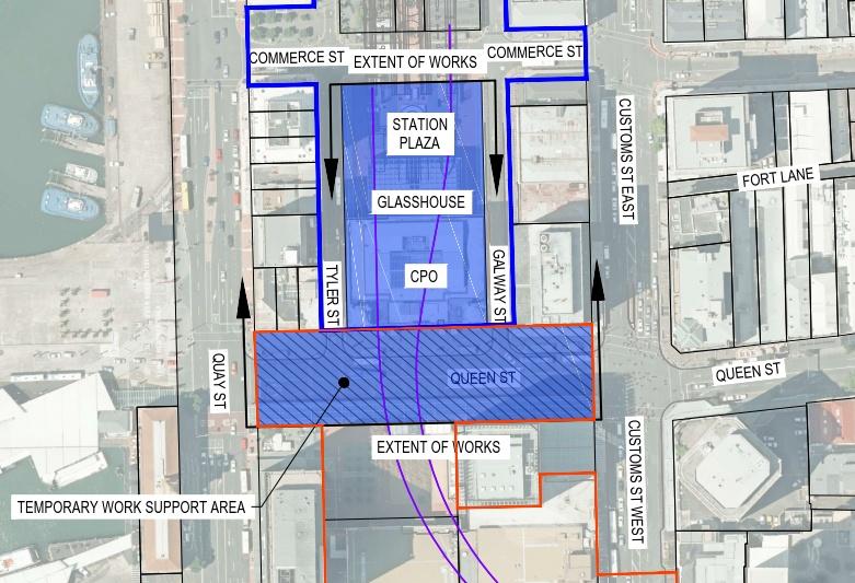
The works (the Project) involve the construction of an extension to the existing passenger rail network from the current termination point within the Britomart Transport Centre (BTC), westwards underneath the former Chief Post Office building (CPO) and Lower Queen Street. The Project footprint is shown generally by the blue shaded area in Figure 1.1 below.

1.1
Purpose of the Urban Design DWP
LEGEND
CRL alignment
BTC designation
CRL designation
C1 worksite
This Urban Design DWP has been prepared to enable the integration of temporary above ground construction works into the surrounding urban landscape, with a particular focus on the temporary Station Plaza Accommodation and Construction Support Areas (CSAs) within Station Plaza (to the east of the CPO and Glasshouse). The objective of the DWP is to:
a Enable the integration of any above ground construction works and structures and the Station Plaza Accommodation into the surrounding landscape and design context so far as reasonably practicable having regard to the temporary nature of the Project;
b Provide for the use and reinstatement of Station Plaza to the same or better standard as existed prior to the Project works being undertaken; and
c Include provision for the use and reinstatement of Construction Support Areas A and C.
This Urban Design DWP incorporates the requirements of BTC designation Condition 33B and will be implemented and complied with for the duration of the construction period. It outlines how the design for the above ground construction works and structures in Station Plaza and the CSAs provides for:
Figure 1 1: Project Footprint
• A safe and secure pedestrian environment through the incorporation, implementation and management of best practice Crime Prevention Through Environmental Design (CPTED) principles, systems and equipment;
• Wayfinding measures that are easy to identify and understand, indicating convenient and safe universal access pedestrian movement routes on public streets, including access to and from the BTC; and
• Construction hoardings and fencing that are integral in the design of the Station Plaza building.
The DWP also broadly outlines how Station Plaza and the CSAs will be reinstated upon the completion of the Project. Further details of this reinstatement will be provided in a future Urban Design DWP, prepared under CRL designation Condition 47, outlining the final design treatment for the public realm following completion of the CRL Britomart to Wyndham Street works
This Urban Design DWP has been prepared by Tonkin + Taylor Ltd (T+T) for the Downer Soletanche Bachy Joint Venture (the Contractor - DSBJV), drawing on material prepared by Auckland Transport’s Principal Technical Advisor, including the ‘Architectural and Urban Design Assessment’ prepared to support the City Rail Link Britomart Transport Centre, Notice of Requirement for Alteration to Designation, dated 15 May 2015. The DWP forms part of the Construction Environmental Management Plan (CEMP) for the Project.
1.2 Relevant Conditions
Table 1.1 identifies the BTC designation conditions 1 relevant to this Urban Design DWP and where they are addressed in the document.
Table 1.1: Urban Design conditions and location in the document
Condition No. Condition
3.2 The Station Plaza Accommodation shall be removed within one year of completion of the Project works.
Relevant section of DWP
Section 9
33B.1 The Requiring Authority shall prepare an Urban Design DWP. The objective of the Urban Design DWP is to:
a) Enable the integration of any above ground construction works and structures and the Station Plaza Accommodation into the surrounding landscape and design context so far as reasonably practicable having regard to the temporary nature of the Project;
b) Provide for the use and reinstatement of Station Plaza to the same or better standard as existed prior to the Project works being undertaken; and
c) Include provision for the use and reinstatement of Construction Support Areas A and C.
33B.2 The Urban Design DWP shall be implemented and complied with for the duration of the construction and operation of the Project.
This document
This document
This document
This document
33B.3 To achieve the above objective the following matters shall be addressed in the Urban Design DWP:
1 Conditions as attached to Auckland Transport’s Confirmation Notice of 17 March 2016 on Notice of Requirement to alter the Britomart Transport Centre Designation
a) Design for the Station Plaza Accommodation and Construction Support Areas A and C should:
(i) Ensure a safe and secure pedestrian environment through the incorporation, implementation and management of best practice crime-prevention-through-environmental-design principles, systems and equipment.
(ii) During construction, wayfinding signs should be easy to identify and understand and should indicate convenient and safe universal access pedestrian movement routes on public streets.
(iii) Any hoardings or fencing required during construction should be perceived as an integral design element of the Station Plaza building.
33B.4 Details of how the Station Plaza and Construction Support Areas A and C will be reinstated upon completion of the Project to:
a) As a minimum, the same standard that existed prior to the project works being undertaken; and
b) In a manner that is coherent within the wider area and/or recent public realm upgrades in the area.
Section 9
Section 9
2 Project Description
2.1 Overview
The Project involves the construction of an extension to the existing passenger rail network from the current termination point within the BTC, westwards underneath the CPO building and lower Queen Street. Separate works are being undertaken to continue the CRL tunnels from this point under the Downtown Shopping Centre site (which is being redeveloped by Precinct Properties), and then up Albert Street.
The Project will involve significant works beneath the CPO, with the construction of two new rail tunnels extending westwards beneath the basement floor level. In lower Queen Street, secant piling will be extended across the road corridor, excavation undertaken to form the tunnels followed by reinstatement of the road corridor following the completion of works. During construction, existing ticketing and retail functions and pedestrian access to the station will be accommodated in Station Plaza, at the rear of the CPO building.
The works will commence in July 2016 and are due to be complete by the end of June 2020
2.2 Construction Methodology
The Project construction works will occur in four main stages as outlined in Table 2.1 below.
Table 2.1: Construction Methodology
Stage Description Dates Duration
Stage 1 –
Temporary station access, construction of temporary accommodation in Station Plaza and streetscape works
Stage 2 – CPO building works, piling, removal of CPO ground floor
Stage 3 – piling, CPO underpinning excavation, tunnel construction and backfilling.
• Construction of temporary station facilities and access in Station Plaza to the rear of the BTC
• Removal of bus stops, shelters and canopies from Tyler and Galway Streets
• Kerbside management changes
• Construction of new vehicle crossing on Tyler Street
• Remove existing stairs and escalators
• Other enabling works
• Construction of dust and noise barriers
• Strip out CPO
• CPO ground floor demolition
• CPO diaphragm wall construction commences
• CPO diaphragm wall construction
• Underpinning of CPO
• Lower Queen Street Piling
• CPO and lower Queen Street excavation
• Tunnel Construction
• Backfill excavation
• Lower Queen Street reinstatement
• Reinstate and re-open CPO
Stage 4 –
Reinstatement & station fit out
• Streetscape reinstatement
• Tie in rail tunnels with existing track alignment
July 2016 to January 2017 7 months
January 2017 to May 2017 4 months
May 2017 to May 2020 36 months
May 2020 to August 2020
Stage Description
• Removal of temporary station accommodation in Station Plaza
Dates Duration
A detailed description of the construction works is provided in the Project CEMP.
3 Urban Environment
This section outlines the existing urban environment in which the BTC and Station Plaza are located and informs the design context for the temporary accommodation buildings in Station Plaza, along with wayfinding measures outlined later in this DWP.
Information in this section is informed by the ‘Architectural and Urban Design Assessment – City Rail Link Britomart Transport Centre, Notice of Requirement Alteration to Designation’ dated 15 May 2015.
3.1 Britomart Transport Centre
The BTC, located in Lower Queen Street, is a critical transport node for rail and bus transportation within the Central Business District (CBD). The site has been a major focus for urban renewal of the Auckland downtown area in recent years.
The BTC facilities are housed over a number of areas and levels, including:
• CPO Ground floor – ticketing, customer service, retail kiosks, waiting areas;
• CPO Upper floors– commercial activities;
• Basement Level 1 Concourse – back of house staff facilities, public toilets;
• Basement Level 2 Platform – tracks, platforms 1 to 5;
• Glasshouse - ground-level eastern entrance to the CPO; and
• Station Plaza – public open space.
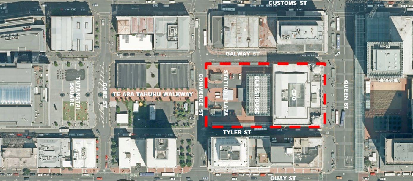
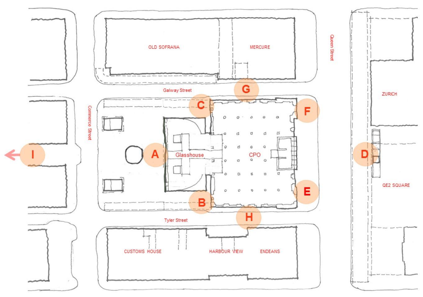
Key elements of the BTC built form are outlined in the sections below and shown on Figure 3.1.
3.1.1 CPO Building
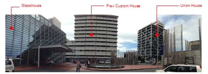
The CPO was constructed between 1909 and 1912 and has been adapted to form the principal entrance and surface structure of the BTC.
The ground floor of the CPO incorporates the public face and main entrance to the BTC, with various activities essential to the transport interchange activities which Britomart provides. These include ticketing windows and machines, customer service and waiting areas. In addition, retail kiosks provide goods and services to rail and bus patrons.
The main entrance to the BTC is through the CPO on Lower Queen Street. Other entrances are located on Galway Street (side and rear entrances), Tyler Street (side and rear entrances), and Commerce Street through Station Plaza. A further entrance is located east of Britomart Place (Takutai Square) within the Atrium on Takutai.
3.1.2
The Glasshouse
The Glasshouse is an addition to the rear of the CPO, adjoining its eastern façade and providing a ground-level entry point to BTC. The Glasshouse was constructed during the prior works to the BTC in 2002. A timber bridge, constructed from recycled timber wharf piles recovered during the 2002 excavation of the train station, connects pedestrians within the Glasshouse from Station Plaza to the CPO. Glazed louvre panels along the façade form a source of natural light and ventilation for the station.
3.1.3
Station Plaza
Station Plaza forms an entrance to the Glasshouse to the east of the CPO. Existing activities within Station Plaza include a kiss and ride facility, bicycle parking, two mobility impaired cardholder car
park spaces, nine P5 car park spaces, one reserved car park space, water skylight feature, street furniture, bus shelter canopies, ventilation stacks and emergency egress.
Station Plaza is bound by Tyler Street to the north, Commerce Street to the east, Galway Street to the south, and the CPO and Glasshouse to the west.
3.2 Built Form
The built form of the area surrounding the BTC is characterised by a combination of refurbished heritage buildings, commercial offices, retail, hotel and residential apartment buildings. Of particular interest is the current collection of retail buildings east of Commerce Street.
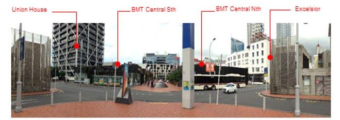
Building heights vary amongst the neighbourhood stock. The heritage buildings in the area are typically four to five stories reflecting the building technology and economics of development at the time. The more recent mid to late century buildings, such as Mercure Hotel (Customs Street) and Harbour View (152 Quay Street), are relatively significant multi-storey buildings of approximately 12 to 15 stories. Recent post millennium building projects, such as the Cooper and Company and Britomart Central developments (Britomart Pavilion), are of a single storey with generous stud heights. The Britomart Central North development, in particular, has a pitched roof effectively giving the built form a two storey bulk.
The built form of the surrounding environment is shown in Figures 3.2 to 3.4.
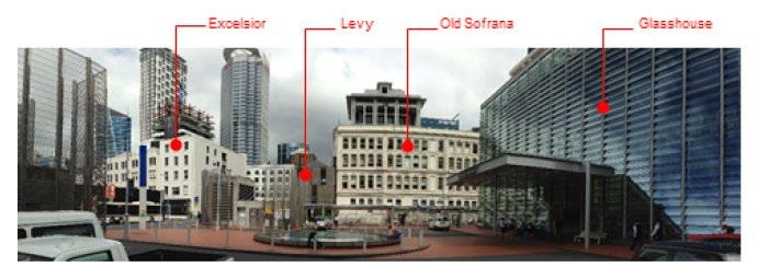
Figure 3.1: Britomart Transport Centre - Site Context
Figure 3 2: Galway Street Site Context Panorama
3.3 Public Realm
The Britomart Precinct includes a number of public spaces, book ended between QEII Square 2 and Takutai Square.
Takutai Square is the main public space within the Britomart Precinct, comprising a large grassed area surrounded by paving and the ‘Pipi Beds’ sculpture and fountain installation in the southeastern corner of the Square. The square is bound by Gore Street to the west and the Ernst & Young Building and Westpac on Takutai Square to the east. Walking street Te Ara Tāhuhu (refer to Figure 3.1) crosses the square and enters Atrium on Takutai, which runs between the two buildings.
The CPO, Glasshouse and Station Plaza areas are utilised by a large cross section of the regular commuting public, tourists and casual visitors.
This Urban Design DWP acknowledges that Cooper and Company are responsible for the design, management and maintenance of the public realm (including public areas and amenities) within the Britomart Precinct in accordance with the Britomart Precinct Public Areas Agreement with Auckland Council.
2 QEII Square is part of the construction site for the Downtown Shopping Centre redevelopment (‘Commercial Bay’) and extension of the CRL rail tunnels beneath the site, being undertaken by Precinct Properties
Figure 3.3: Commerce Street Panorama
Figure 3 4: Tyler Street Panorama
Rabobank
Rabobank
3.4 Transport Environment
The streets surrounding the BTC are currently used by private vehicle and bus transportation. Key streets adjacent to the BTC are Lower Queen Street, Commerce Street, Tyler Street and Galway Street.
• Lower Queen Street - classified as a pedestrian mall under the Auckland Council District Plan (Central Area Section), Lower Queen Street is closed to general vehicle traffic between Tyler and Galway Streets. However, traffic can turn left onto Lower Queen Street from Galway Street and access Tyler Street from Quay Street and Lower Queen Street Buses were relocated from Lower Queen Street in April 2016, in advance of the Project. Bus facilities (bus shelters etc ) are currently being removed from the public realm. The area is highly pedestrianised due to its proximity to the BTC, the Auckland Ferry Terminal and the former Downtown Shopping Centre 3 .
• Commerce Street – located to the east of Station Plaza, Commerce Street allows for traffic in both directions and comprises bus stops, short stay parking and loading zones. Uncovered cycle parks are provided within Station Plaza, near the corner of Tyler Street and Commerce Street.
• Tyler Street – Tyler Street, between Lower Queen Street and Commerce Street accommodates eastbound vehicle movements (reversed in advance of the Project) while westbound vehicle movements only, are accommodated from Commerce Street to Britomart Place. Between Britomart Place and Commerce Street, short term parking/loading spaces (pick up and drop off) and taxi ranks are provided. As of April 2016, all Project related construction trucks and heavy traffic (including buses) were restricted from using Tyler Street between Commerce Street and Britomart Place, in advance of the Project (refer to Figure 3.5 below).
• Galway Street – Galway Street provides for westbound vehicle movements only between Britomart Place and Lower Queen Street. The street provides for bus stops, short term parking, loading zones and taxi ranks. As of April 2016, Project related construction trucks and heavy traffic (including buses) were restricted from using Galway Street between Commerce Street and Britomart Place, in advance of the Project (refer to Figure 3.5 below).
3 The Downtown Shopping Centre is being redeveloped as part of Precinct Properties ‘Commercial Bay’ Development commencing construction in mid-2016
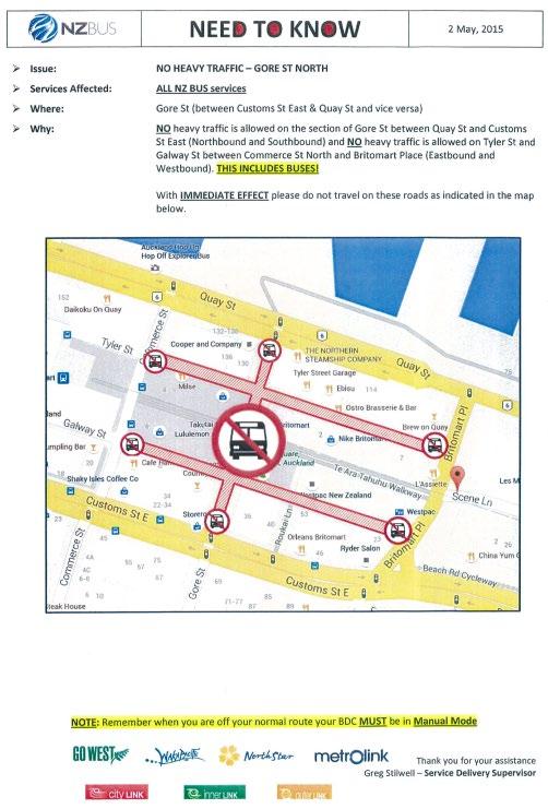
Figure 3.5: Notice provided to NZBUS, AT bus subcontractors, illustrating the heavy traffic ban on Galway and Tyler Streets east of Commerce Street.
3.5 Pedestrian Movements
Pedestrian surveys were undertaken around the BTC in 2013 to inform the BTC Alteration to Designation NoR and in 2015 as part of the preparation of the Transport, Access and Parking (TAP) DWP for the Project (refer to Section 3.2.2 of the TAP DWP).
The surveys indicated high levels of pedestrian activity on the western side of the CPO building and Lower Queen Street. Predominantly, the south-west corner of the BTC (Entrance F on Figure 3 6) is
busiest followed by the north-west corner and in turn the eastern side of the Glasshouse (Entrances E and A respectively on Figure 3 6)
It should be noted that the closure of the CPO from Stage 2 of the construction works (end of January 2017), will necessitate redirection of rail passengers to the new BTC entrances through the temporary accommodation buildings in Station Plaza The intent is to redirect rail passengers and the public as follows:
• To Commerce Street via Customs Street at the Queen Street intersection, when moving from street to station, and from Commerce to Custom when exiting the station.
• To Commerce Street, via Quay Street at the Queen Street intersection when moving from street to station, and from Commerce to Quay when exiting the station.
3.6 Public Transport Facilities
The following key public transport facilities are located within or within close proximity to the Project area:
• Auckland Ferry Terminal;
• Shed 10, Auckland cruise ship terminal;
• BTC;
• Other bus services to the North Shore, East and West Auckland; and
• Taxi stands (currently Galway and Tyler Streets but to be relocated as part of the Britomart Streetscape Changes)
Figure 3 6: CPO Main Pedestrian Entry Flows
4 Station Plaza Accommodation
4.1
Overview
During Stage 1 of the Project (and prior to the commencement of construction works in the CPO and Lower Queen Street), temporary accommodation buildings will be established in Station Plaza, adjacent to the Glasshouse adjoining the eastern edge of the BTC.
The temporary accommodation buildings will house key station facilities and operations (including ticketing, services, retail staff facilities and station operation functions) that will be relocated from within the CPO building to Station Plaza. Relocation of these facilities will enable uninterrupted operation of the BTC during construction works within the CPO and Lower Queen Street
The temporary accommodation will serve as the main entrance to the BTC from around January 2017, following which the CPO will be closed to the public in order to enable construction to be undertaken beneath the building. The new BTC entrance will remain via Station Plaza, until the CPO is reinstated and re-opened to the public in early 2020 (end of Stage 3 of the Project)
4.2 Temporary Accommodation Buildings
The design of the temporary accommodation buildings in Station Plaza is outlined below and shown by the 3D images included in this DWP, along with the Temporary Accommodation Drawings provided in Appendix A.
4.2.1 Building Elements
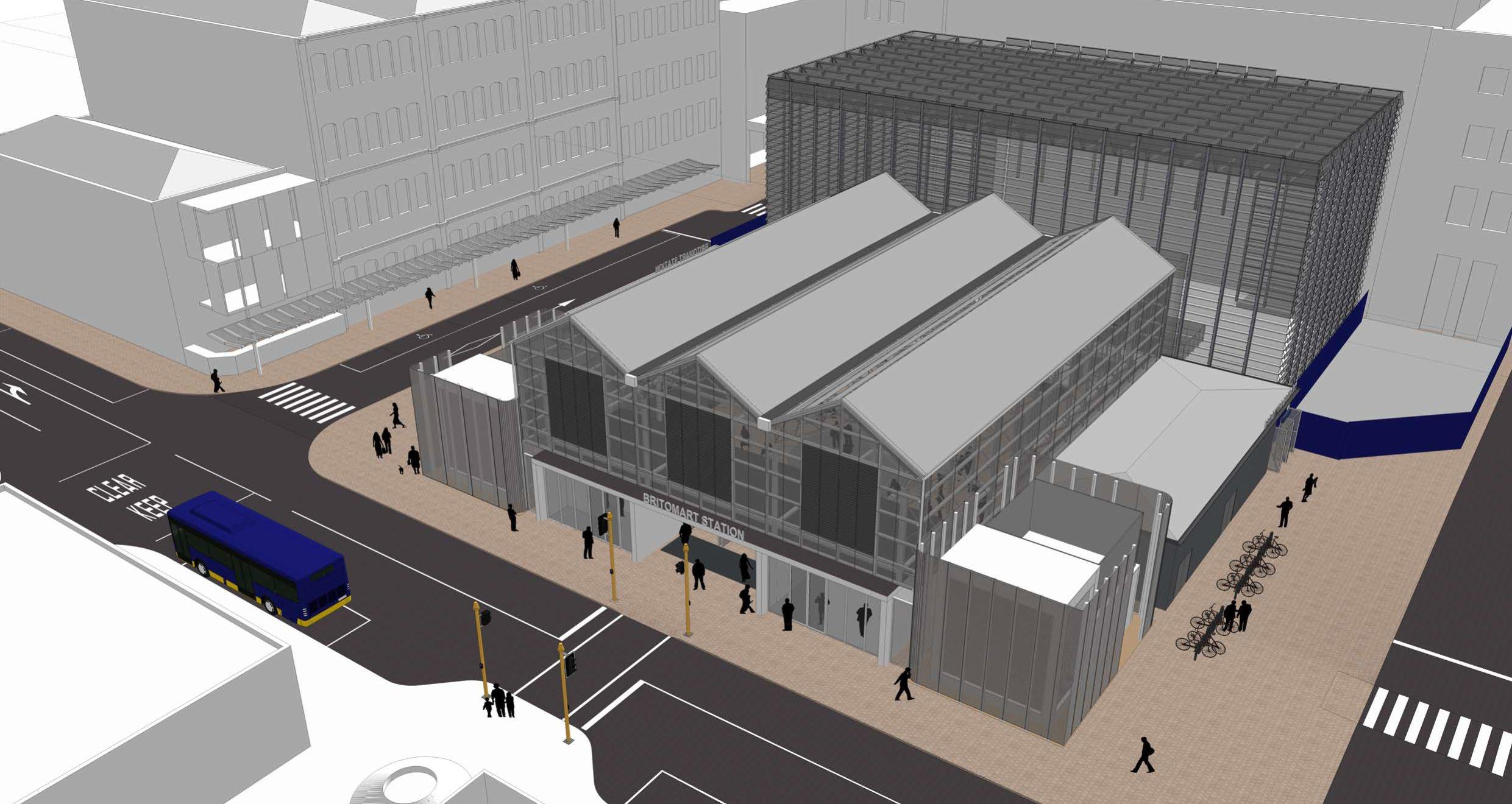
The temporary accommodation buildings comprise three main architectural elements as described below:
• The large roof canopy;
• The two accommodation blocks; and
• The customer service facility and two retail units.
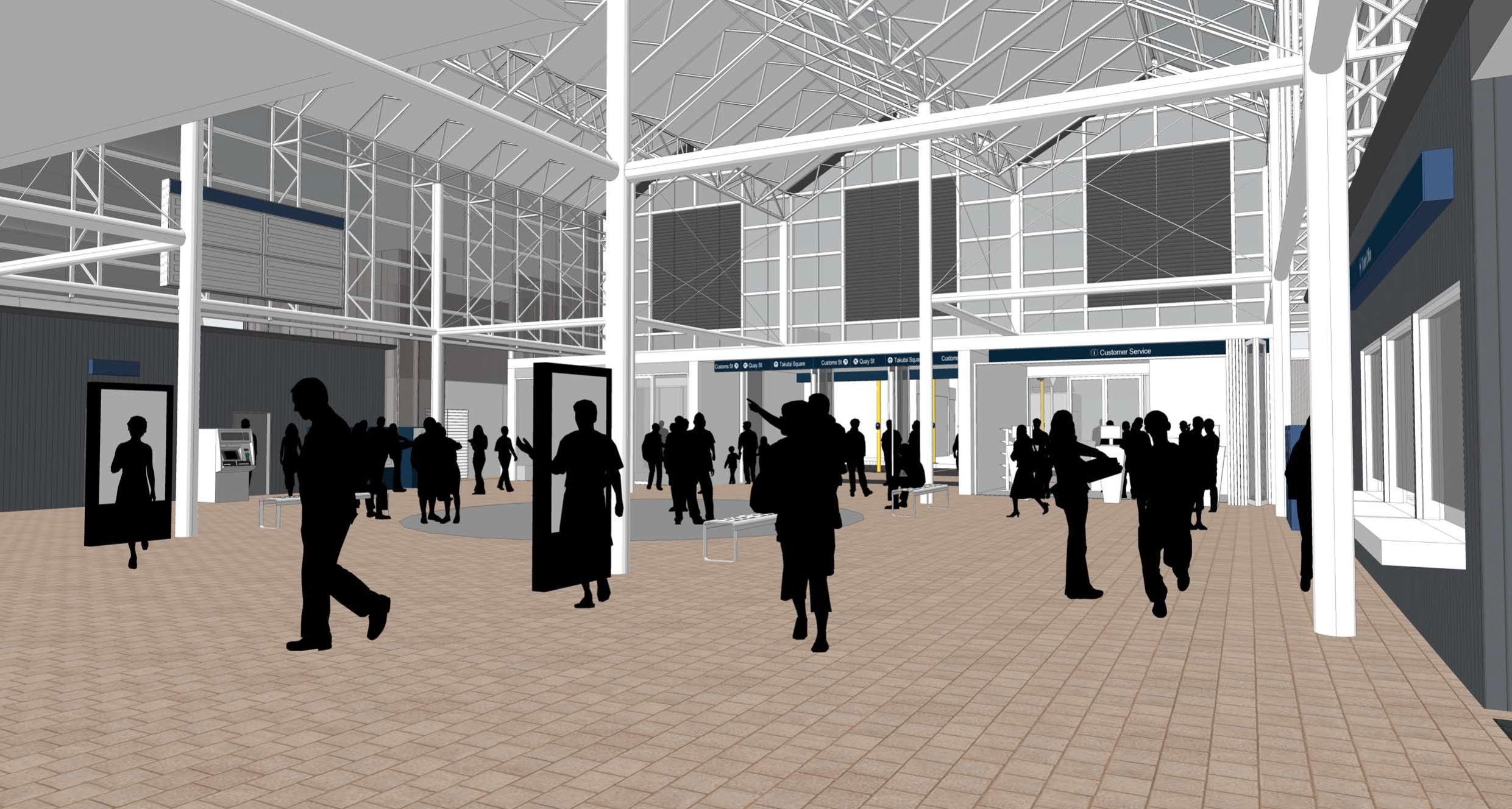
The building forms create a perimeter block, which encompass an internal covered central area, open to the public and rail passengers. The central area forms the concourse for rail patrons to access the rail platforms in the BTC through the Glasshouse.
Refer to Figure 4 1 for a 3D aerial image of the temporary accommodation buildings.
4.2.2 The Large Roof Canopy
The large roof canopy will cover Station Plaza. It is comprised of three distinct gable end roof forms supported by a structural steel frame. The Commerce Street frontage extends to ground level and is punctuated by the central entry gates, a customer service facility and a retail tenancy, all of which open and are glazed to the street. The roof structure will be approximately 12 m above the existing ground level, 28.5 m in length and 22.5 m width.
The roof utilises a prefabricated framing and roofing cassette system commonly used in buildings where consideration of the urban environment is important. This system uses a scaffold roof truss with profiled sheet roofing either in transparent or opaque finishes, supported by a purpose made steel frame of beams and columns.
The existing Glasshouse structure is a significant part of the BTC station architecture. The large roof and Commerce Street façade of the temporary accommodation emulate this design with the use of a simple framed structure with transparent cladding and louvers, to offer views of the structure during the day and potential interest at night with suitable illumination.
The intent of the large roof is to provide shelter to the Station Plaza area in order to protect the use of facilities currently undertaken in the BTC from inclement weather, particularly during the winter months. The design of the roof structure also makes use of natural light, which is important for the public in this environment, in terms of comfort and amenity.
Refer to Figure 4 2 and Figure 4 3 for 3D images of the large roof element of the Station Plaza temporary accommodation
Figure 4 1: Station Plaza Temporary Accommodation 3D Aerial View
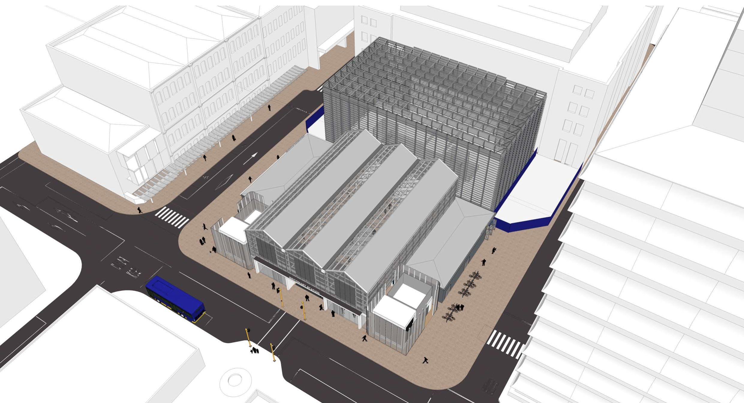
4.2.3 Temporary Accommodation Buildings
Two single story accommodation blocks will be constructed to the north and south of the central plaza, to the rear of the vent structures. The northern accommodation building aligns with the existing northern vent structures and the northern outside wall of the Glasshouse (refer to Figure 4.2). The southern accommodation block is built out slightly from the southern vent structure and southern wall of the Glasshouse (refer to Figure 4.3)
The temporary accommodation buildings will contain the following BTC functions and facilities:
Figure 4.2: 3D View of the large roof and temporary accommodation buildings
Figure 4 3: 3D View of the large roof and temporary accommodation buildings from the South-east
• Northern block – staff facilities including toilets, sick bay and lockers, public toilets, rubbish room and plant spaces (communications room). The northern façade of this building fronting Tyler Street incorporates doors to provide access to service areas within the station.
• Southern block – ticketing facilities and associated offices, staff facilities including toilets, kitchen, and plant spaces (communications room and electrical distribution board). A retail unit will be located in this block fronting Galway Street.
The buildings will be approximately 4.25 m in height with a flat roof. The northern accommodation building will be approximately 16 m in length, while the southern accommodation building approximately 12 m in length. The structures will be lightweight timber and steel frame construction.
Mesh security gates will be installed at the Commerce Street, Galway and Tyler Street entrances to the temporary accommodation. The gates will provide for security and crowd control within the station. The Tyler Street gates will be in line with the temporary accommodation façade, while the Commerce and Galway Street gates are slightly set back from the building façade and street, in order to provide shelter at the station entry points and a decision point for pedestrians looking to move east from the station.
4.2.4 Retail and Customer Service Facilities
Two retail units will be incorporated into the temporary accommodation buildings
One retail unit will be integrated into the Commerce Street building frontage, sharing the canopy covering the entry gates and customer service facilities. A second unit will be integrated into the southern accommodation block, fronting Galway Street The unit will be transparent to Galway Street and to the entry corner adjacent to the Glasshouse, for enhanced visibility and activation of the corner.
A customer service facility will adjoin the southern side of the main station entry The area will include computer help desks, information stands, and customer service staff. The intent is to offer a transparent and customer friendly service area that is easily visible to rail passengers and members of the public
Seating will be provided in the central Station Plaza area, sheltered under the large roof canopy.
Both units will be approximately 7 m in length and 5 m in width. The units will be of lightweight timber frame construction with supporting structural, steel components.
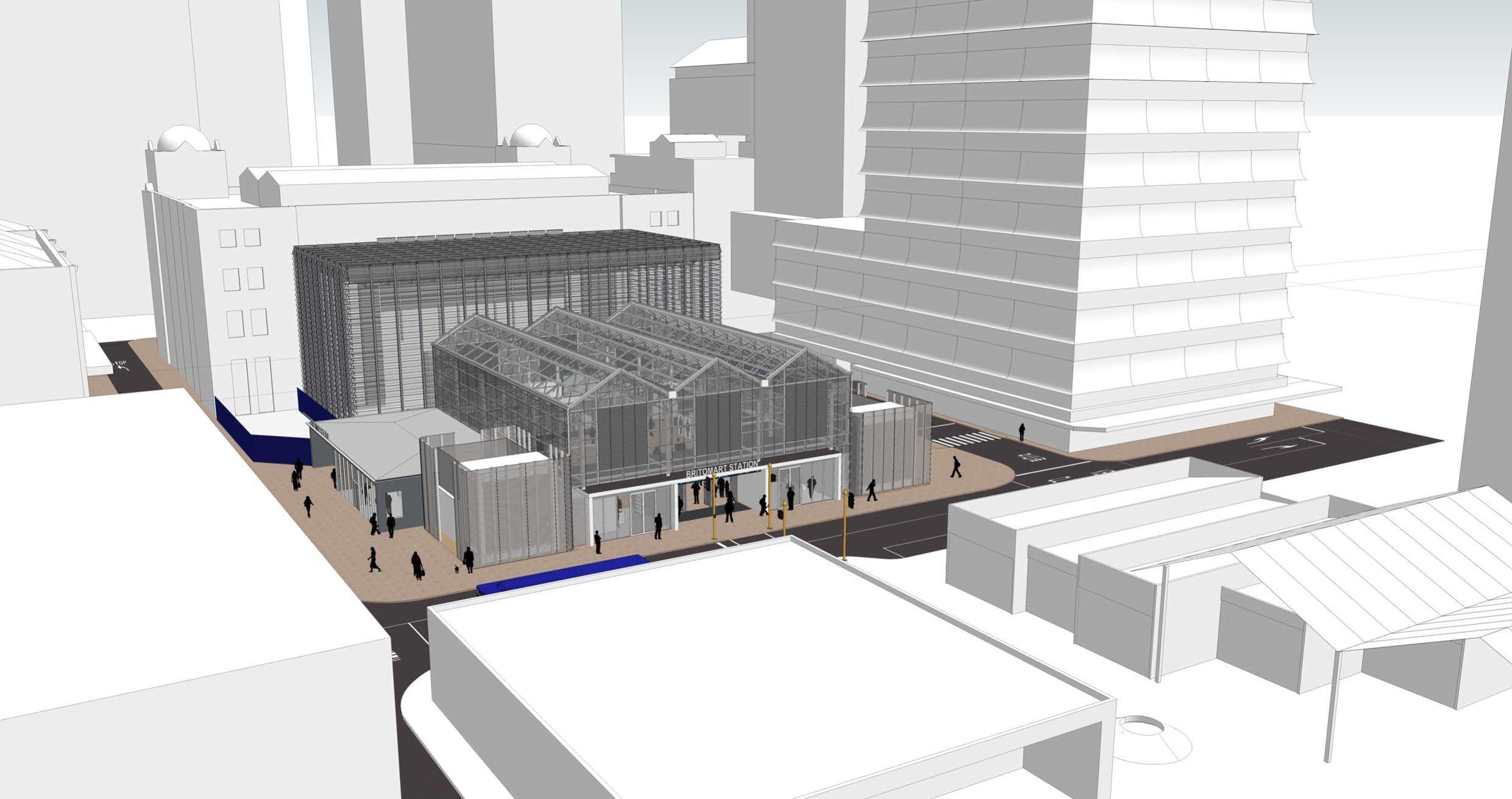
Figure 4.4 provides a 3D view of the Commerce Street frontage, including the central main entrance with the customer service facility and a retail unit immediately adjacent to the south and north, respectively.
4.5 provides a 3D view of the interior
4.3 Architectural Language
The design and architectural language of the Station Plaza temporary accommodation has been informed by buildings in the surrounding area. In particular, the success of the Britomart Pavilions in terms of capturing public space under build form, such as roofs, the use of rectilinear forms and simple material palettes and responses to the street environment using architectural detail and other design elements to create interest.
Figure 4 4: 3D View of the Commerce Street Facade
Figure
of the temporary accommodation buildings.
Figure 4 5: 3D View of Interior of temporary accommodation buildings
The architectural language of the Station Plaza temporary accommodation comprises the following elements:
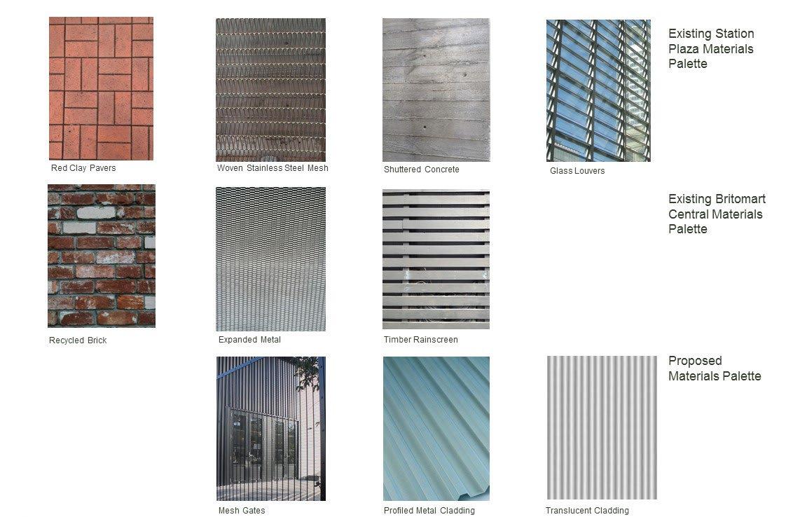
• Profiled metal cladding – run in a vertical orientation to emphasise this proportion as preferred by the Britomart Precinct design criteria outlined in the Auckland Council District Plan (Central Area Section) (ACDP) The linear grain picks up on the timber rain screen cladding of the Britomart Pavilions and existing shuttered concrete structures of the Station Plaza.
• Profiled transparent cladding – similar profile and orientation to the metal cladding described above but used to provide views through the structures and to provide natural light.
• Glazing – large shop front glazing areas will be a feature of retail and customer service areas in the temporary accommodation, providing visual transparency and interest to and from the street.
• Flat roofs or low pitch roofs – similar to the retail units in Britomart Pavilions, in order to emphasise simplicity of form and to compliment the adjacent vent structures. These forms are intended to be subordinate to the large roof feature.
Implementation of these elements in the design is as follows:
• Main roof – will comprise a combination of profiled transparent and metal cladding material on a steel structural frame of beams and columns. Columns will be carried on pad foundations on top of the railway station box. The profiled metal cladding is used to limit heat gain through the north facing slopes of the roof.
• Accommodation blocks – lightweight timber frame construction with supporting structural steel components on pad foundation system. Clad in profiled metal and featuring shop front glazing to Galway Street.
• Retail / Customer Service units – will be of lightweight timber frame construction with supporting structural, steel components, commercial shop front glazing systems, membrane roofing, drawing upon the design of retail units in the Britomart Pavilions.
Figure 4.6 outlines the materials palette for the Station Plaza temporary accommodation structures.
4.4 Design Response
Part 14.6 ‘Britomart Precinct’, of the ACDP has been used to inform and guide the development of the architectural response for the Station Plaza temporary accommodation buildings. The design of the temporary accommodation buildings supports the environmental results anticipated by the ACDP, through the following elements and features:
Alignment to the street
• The temporary accommodation will be orientated parallel to Tyler and Galway Streets to the north and south respectively. To the east, the orientation is parallel to Commerce Street, while the frontage aligns to the front faces of the two Station Plaza vent structures.
Façade continuity with the built environment
• The Tyler and Galway Street facades more or less continue the scale of the vent buildings and building scale established by the structures on the opposite (eastern) side of Commerce Street (Britomart Pavilions). The Commerce Street elevation copies the pitched roof forms of the structures facing the Te Ara Tahuhu axis leading to the Station Plaza.
Urban form of human scale
• The temporary accommodation buildings establish a perimeter block form through the alignment of building frontages to Tyler, Commerce and Galway Streets. The building forms encompass an internal covered square open to the public, which also serves as the concourse for train patrons to embark down to the station platform through the Glasshouse.
• The Te Ara Tahuhu axis aligns with the main station entrance on Commerce Street. The existing pedestrian pathways across this frontage and down Tyler and Galway Streets are retained.
Figure 4.6: Temporary Accommodation Building Materials
Appropriate building scale
• Both accommodation blocks are one storey in height, with the cladding orientation, including window proportions of the Galway Street frontage emphasising the vertical dimension.
• The Commerce Street frontage is broken down into 3 gable forms with transparent cladding in a vertical orientation with visible vertical structure. The building scale is similar to the works on the opposite side of Commerce Street
Security, surveillance and vitality
• The accommodation buildings contain public transport centre facilities/services and two supporting retail tenancies, once of which fronts. Commerce Street and the other Galway Street. The station has security monitoring 24/7. Refer to the CPTED assessment of the temporary station accommodation in Section 7.2 of this DWP for further detail in this regard.
Public space
• The temporary station accommodation structure acts like a large covered pavilion within the public realm, which is open to the public during the opening hours of the Britomart Station.
Variation of architectural elements
The temporary accommodation buildings address two forms of public space at ground level - being the adjacent streetscape and Galway, Commerce and Tyler Street footpaths; and the Station Plaza central area, which the large roof structure will cover. Specifically:
• Ground level architectural elements to the street include entranceways, windows and doorways
• The Station Plaza environment encompasses retail elements, ticketing windows and a central customer service area.
Definition of the edge
• The design of the northern accommodation block aligns with the faces of the existing Glasshouse and vent structures, while the southern accommodation block is built out slightly from the Glasshouse and vent structures, punctuated by the Galway Street retail frontage. The Commerce Street frontage largely aligns with the two existing vent structures, with the building frontage punctuated by retail frontage and entry as described above.
• Variation is achieved by the contrast in finishes between those of the existing the Glasshouse (glazed louvers with basalt base), vent structures (mesh on frame, shuttered concrete and aluminium louvers) and those of the proposed new accommodation blocks (profile metal cladding).
Cohesive streetscape
The temporary accommodation acknowledges the streetscape character in two ways:
• The building frontages along Galway and Tyler Streets reflect the design and detailing of adjacent developments facing the Te Ara Tahuhu axis, in particular the Britomart Pavilions, which combine small pavilions with pitched gable roof forms providing shelter to courtyard spaces. The temporary accommodation buildings pick up on the built form of these structures, particularly the roof forms as featured on the Commerce Street frontage
• The central roof form that shelters the Station Plaza uses the transparency characteristic of the adjoining Glasshouse facades to provide shelter to the interior central plaza public space.
Materials and colour
A twofold strategy has been adopted with regards to interpretation of the surrounding built form colour and materials in relation to the temporary accommodation buildings and large roof structure:
• The design of the temporary accommodation borrows from adjacent developments that have resonated with the general public – namely the developments to east of Commerce Street (Britomart Pavilions) The linear grain picks up on the timber rain screen cladding of the Britomart Pavilions and existing shuttered concrete structures of the Station Plaza.
• There is reinterpretation of the established materiality of the site, such as in the use of transparent materials, exposed steel structures, metallic and natural finishes. This is featured in the use of transparent and profiled metal cladding and exposed steel roof structure covering the central plaza area, and use of natural brick pavers for the Plaza floor.
4.5 Architectural Landscape Features
All existing elements (such as seating, rubbish bins, canopies), other than the existing paving in Station Plaza, will be removed to allow construction of the temporary station accommodation and to facilitate clean site lines and uncluttered pedestrian movements across the corners of the site.
The existing vehicle kiss and ride, and disabled area parking will be paved over. It is proposed the existing kerbing will be set aside and new pavers will be laid over the existing asphalt base to integrate with the current brick pavers.
It is proposed to relocate the bicycle parking standards on Tyler Street, slightly closer to the Tyler Street temporary accommodation frontage and enhance bike parking.
Following the completion of construction, Station Plaza will be reinstated to the same standard as existed prior to the Project. Elements, such as public seating and rubbish bins, will be replaced with new CBD theme furniture. Refer to Section 9 of this DWP for further detail on the reinstatement of Station Plaza.
4.6 Visualisations
Figures 4.7 – 4.10 show visualisations of the temporary accommodation in Station Plaza exterior and interior day-time and night-time views.
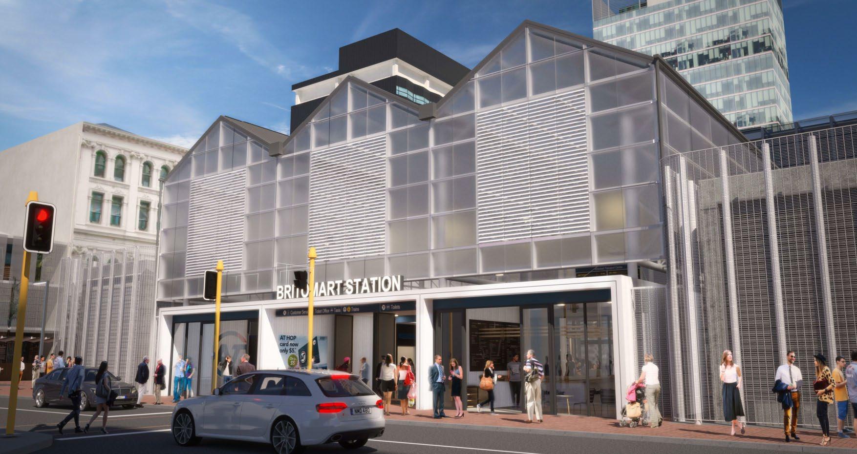
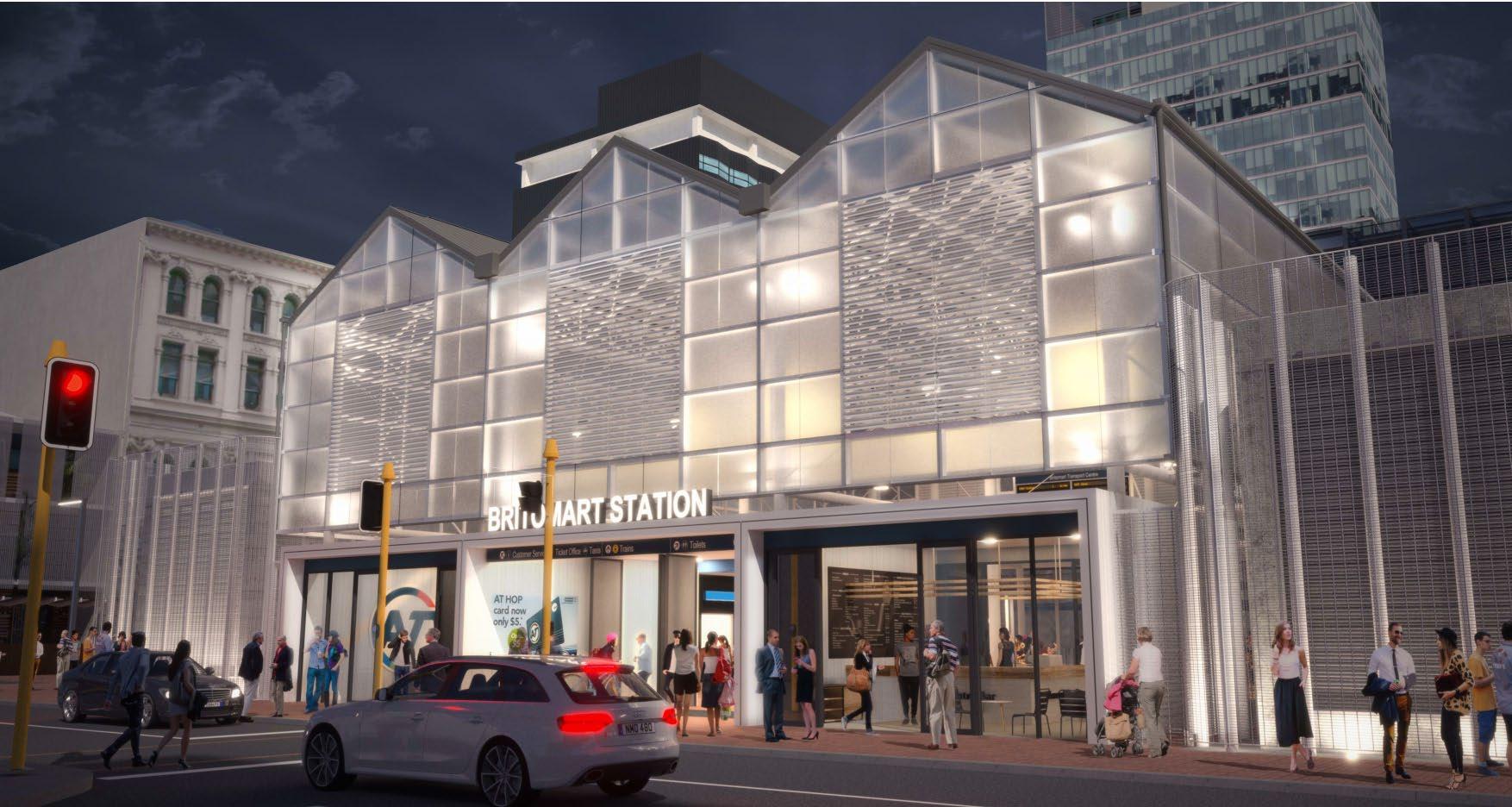
Figure 4.7: Temporary Accommodation – External Day-time View
Figure 4 8: Temporary Accommodation – External Night-time View
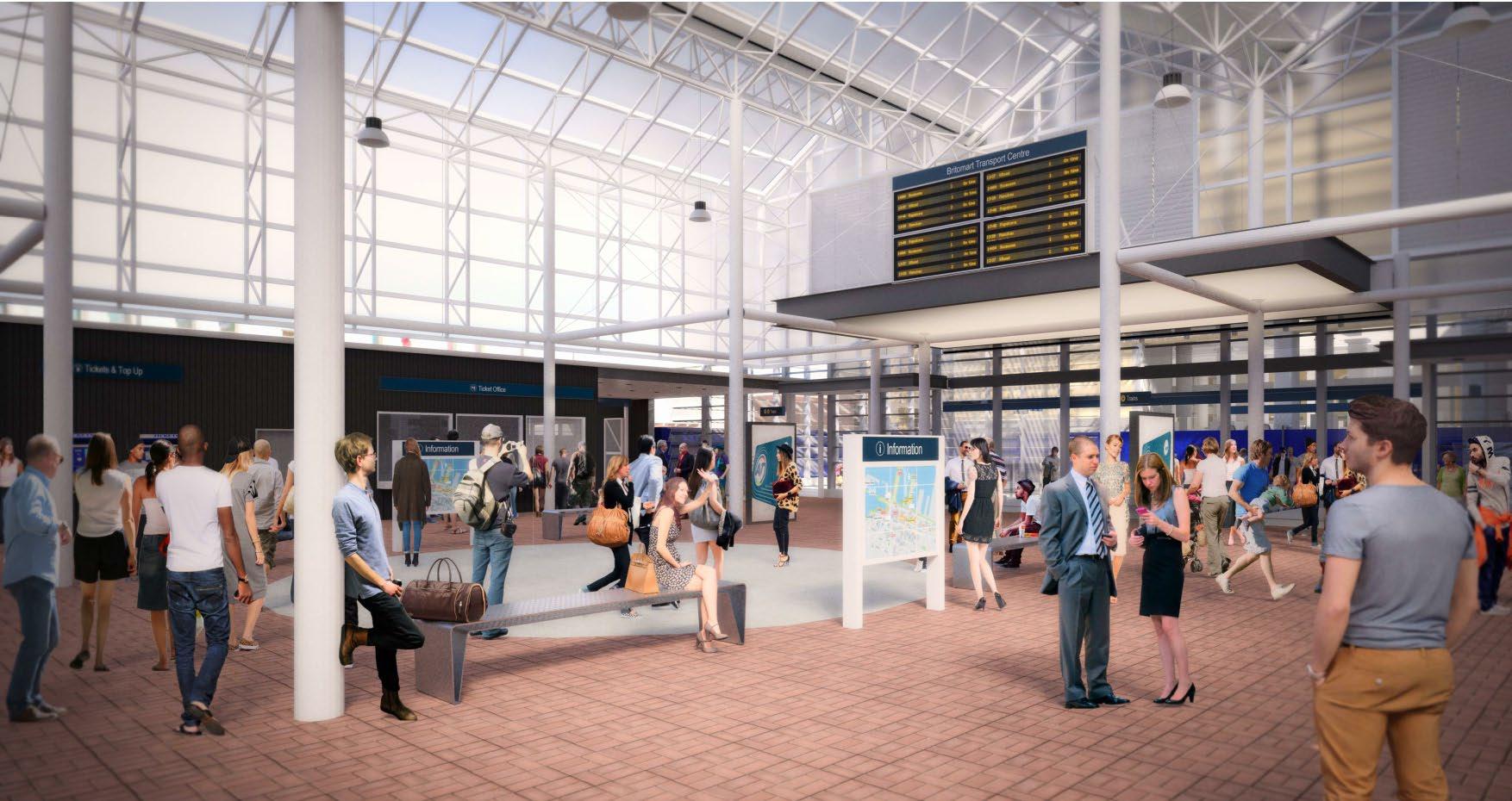
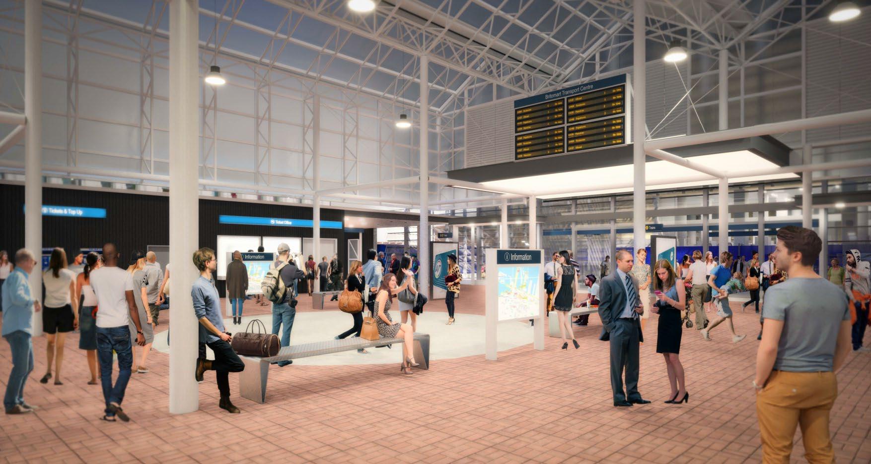
Figure 4 9: Temporary Accommodation – Interior Day-time View
Figure 4.10: Temporary Accommodation – Interior Night-time View
5 Construction Support Areas
5.1 Overview
Construction Support Areas are required to support the construction works and provide the general activities, such as site offices and construction personnel amenities, construction vehicle and machinery parking, loading and unloading of construction materials, storage of construction materials, waste storage and collection.
Two CSA will be located adjacent to the Glasshouse and Station Plaza during the construction phase of the Project (refer to Table 5 1 and Figure 5 1).
Table 5.1: Construction Support Areas
Construction Support Area Location Construction zone supported
A Galway Street Supports temporary accommodation works in Station Plaza
B Lower Queen Street Supports CPO and Lower Queen Street construction
C Tyler Street Provides construction access to the CPO
400 m2
3,500 m2
400 m2
Plant/Activities
• Material storage
• Storage of plant and equipment
• Crane location and access to CSA A and the CPO
• Stormwater and groundwater treatment tanks
• Bentonite treatment plant
• Jet grout pump and mixing plant
• Material storage
• Storage of plant and equipment
• Temporary site office and workers amenities during Stage 1 of the Project
• Material storage
• Storage of plant and equipment
• Crane location and access to CSA C and the CPO
• Main vehicle entrance to the CPO building
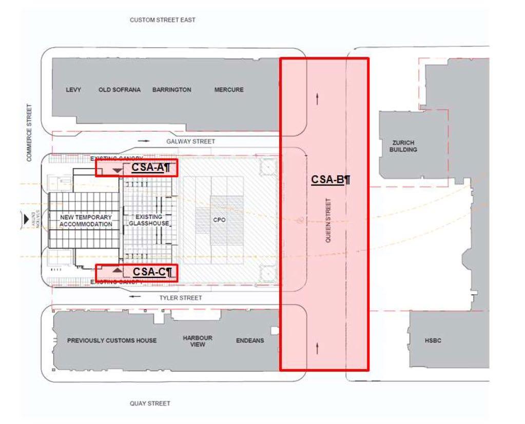
Note: Blue hatched areas on Figure 5.1 show the areas within Lower Queen Street that will be maintained as traffic lanes in order to provide vehicle access from Lower Queen Street to Tyler Street and Galway Street into Lower Queen Street
5.2 Construction Fencing
All CSAs will be separated from the adjacent public realm through the use of construction fencing and hoardings as outlined in Section 6 of this DWP.
Construction fencing, along with Project hoardings and wayfinding information (refer Section 6 of this DWP) will serve to screen part of the construction areas from the adjacent public realm and integrate the areas into the surrounding landscape, hence minimising the visual impact from the CSA’s.
As the CSA fencing will be approximately 1.8 m in height, some construction plant and equipment (such as silos for the bentonite treatment plant and larger plan) will remain visible above the top of the fencing.
5.3 Site Housekeeping
All CSAs will be maintained in a tidy and neat condition, and due care shall be taken to prevent impacts on adjoining public or private property. All litter and liquid contaminants will be removed and disposed of in an appropriate manner. Equipment and materials will be stored safely, securely and in an orderly manner. No plant, buildings, debris, or other materials shall be placed or allowed to roll, wash, slide or blow across adjacent boundaries.
Figure 5 1: Construction Support Areas
On completion of construction work in individual areas, and particularly after the completion of each Project stage, all plant, temporary facilities, debris surplus and foreign materials will be removed from the site as practicable
5.3.1 Graffiti Management
Graffiti will be discouraged by painting murals or posting other Project graphic content on the hoardings (or construction fences where practicable) in order to avoid creating a blank canvas for graffiti. In turn, Project hoardings will be subject to a graffiti guard treatment, in order to minimise the potential for graffiti around the site.
All Project construction fences and hoardings will be inspected on a weekly basis for integrity and graffiti. A small quantity of paint will be kept on site to paint over graffiti on any fences that are not covered with hoardings. The target set for painting over graffiti is within 24 hours of identifying the problem
6 Construction Hoardings and Fencing
Construction hoardings and fencing will be erected around all Project construction areas. Hoardings and fences are required to:
• Delineate construction areas from the adjacent public realm;
• Secure work sites;
• Provide for the safe passage of pedestrians (and vehicles) through, or adjacent to, construction sites; and
• Provide for the safety of Project workers from passing vehicles.
The size of hoardings and fencings, materials used, along with the interface of hoardings with the adjacent public realm can impact on the way people experience construction areas Hoardings can be used for various purposes, including:
• To tell the public, stakeholders and communities about the Project i.e. communicate the Project story;
• Provide Project contact details, showcase the construction partners;
• Let the public watch elements of the Project take shape; and
• Engage the public in the Project, and its role in the future of the City.
Ensuring that hoardings are integrated into the surrounding landscape and incorporate good design principles are key to enhanced hoarding design. The following section provides an outline of the types and locations of hoardings required for the Project, along with an outline design principles for the hoardings.
6.1 Overview
Construction fencing and hoardings will be required around all Project construction areas, including CSAs. The CRL Contract 1 Hoardings Plan provided in Appendix B to this DWP, and Table 6.1 provide an overview of the types of construction fencing/hoarding and the location of these structures around the Project area.
Work sites will be surrounded by hoardings to an overall height of at least 1.8 to 2 m. Higher temporary hoardings will be provided around certain construction activities, such as piling works where these adjoin pedestrian flows, in order to provide for the safe passage of pedestrians.
Table 6.1: Overview of Project Hoardings and Fencing
Construction Area Hoardings/Fencing Type
Construction Support Areas A and C (Station Plaza)
Station Plaza Temporary Accommodation
• Mesh screen or plywood fencing (approximately 1.8 m high) will be erected to the north and south of the Glasshouse to delineate CSAs A and C.
• Full height gates will be installed at the entrance to the CSAs to provide for vehicle and truck access.
• Mesh screen fencing (approximately 1.8 m high) will be erected around the edge of Station Plaza during construction of the Temporary Accommodation Buildings
Duration
• July 2016 –August 2020
• July 2016 –January 2017
• January –August 2020
Construction Area Hoardings/Fencing Type
CPO
Lower Queen Street during public activation
• A barrier will be installed between the CPO and the existing Glasshouse to separate the CPO construction area from the public BTC area.
• External CPO doors (apart from the door in the northeastern corner adjacent to CSA C and the north west corner where the loading platform is located) will be covered with a solid plywood barrier.
• During the Lower Queen Street Public Activation (April 2016 to 1 May 2017), mesh screen fencing will be installed along the Lower Queen Street footpath outside the CPO out into Lower Queen Street. The fencing will be integrated into the Lower Queen Street Public Activation.
• Full height gates will be installed at the northern and southern ends of the fencing in order to provide vehicle and truck access to the work area.
Duration
• January 2017December 2019
• January 2017 – December 2019
• February –April 2017
Lower Queen Street (main construction works)
• Following the Lower Queen Street Public Activation period, mesh or plywood fencing will be installed around the boundary of the Project footprint in Lower Queen Street Concrete barriers will be installed as required for traffic safety
• Full height gates will be installed at the northern and southern ends of the barriers in order to provide vehicle and truck access to the work area.
6.2
Design principles
• May 2017 –December 2018
The design philosophy and principles for hoardings to be erected within and around the Project area (inclusive of Station Plaza) during construction is as follows:
1 Creative and engaging
Successful hoardings are unique to the Project and an opportunity to set the tone of the Project, reflect the values central to the Project and integrate branding Hoarding designs should be creative, attractive and engaging
2 Visually define the Project area
Hoardings shall include visual cues which clearly defines where the Project begins and ends. There is an opportunity to signal the scale of the project or hint at future flows and movement of people and trains.
3 Integrate with the surrounding environment
Hoardings shall use materials and colours consistent with the materials palette, look and feel of the surrounding built form (Station Plaza and the BTC) to the extent practicable.
4 Includes clear and legible information
Hoardings shall display clear and legible information that is easy for pedestrians (and motorists as relevant) to read and understand. Project related images shall be used at a large scale to occupy the normal pedestrian field of peripheral vision.
5 Cohesive and Co-ordinated design approach
Adoption of a co-ordinated design approach and branding strategy to ensure a cohesive and consistent look and feel to all hoardings and construction fencing around the Project area. It is likely that branding of the hoardings will incorporate the CRL ‘The Build is ON’ branding.
6 Provide Project contact information
Hoardings shall include Project contact information, such as the Project hotline, website address
7 Showcase the delivery team
Hoardings shall include an area for displaying the construction team members and clearly indicate that the works are a City Rail Link Limited (CRLL) Project.
8 Provide public viewing of the construction
People are naturally curious, and builds are fascinating. People want to watch the activity. Following identification of spots which offer a good view, viewing windows will be located in hoardings adjacent to the footpath edge and where it is safe to do so, not the road. Viewing windows can be integrated into the artwork, and any shape is possible as long as viewers are protected from potential construction hazards.
9 Portray the past, present and future of the site
During extended construction periods, people can find it hard to remember what was there before, and feel a sense of anticipation or connection to what’s coming. Hoardings can include:
• Link to the past: using images or brief information to help people remember.
• Link to the present: Projects develop quickly, and people like to be informed and updated on progress.
• Links to the future: Consider what people want to know about the project. What is it? How will they benefit? When will it be finished? Include any other points of interest, such as innovative technology or sustainability.
Information needs to be relevant throughout the project cycle so hoardings should be adaptable for periodic change.
10 Include wayfinding
Recognise that a change in the built environment landscape can affect how people find their way around. Wayfinding consists of tools which can help people better navigate through the environment. Refer to Section 8 of this DWP for further detail on wayfinding measures to be implemented during the Project.
6.3 Construction Fencing and Hoarding
6.3.1
Construction Fencing
As outlined in Table 6.1, construction fencing around the Project area will take the form of mesh fencing with printable screens and solid barriers (concrete or plywood). The use of concrete and mesh materials in Project fencing, will be consistent with the materials palette (colours and textures) for the existing Station Plaza built form and will visually integrate with the palette for the Station Plaza temporary accommodation buildings.
Indicative examples of the fencing typologies that may be used around the Project area are shown in Figure 6.1 and Figure 6.2.
6.3.2
Hoardings
Hoardings around the Project area will serve multiple purposes during the construction works. Specifically, hoardings will:
• Display Project information and communicate the Project story i.e. timelines, images, storyboards, milestones etc.;
• Advise the public that businesses remain open during the construction works and promote local businesses (as appropriate);
• Provide opportunities for public viewing as appropriate;
• Include wayfinding measures; and
• Provide opportunities for mana whenua involvement or the use of other measures to enhance public amenity and connection to the Project.
Essentially, hoardings around the construction zone will serve to add interest to the public realm, and avoid blank monotonous surfaces and associated impacts of hoardings on the adjacent public realm
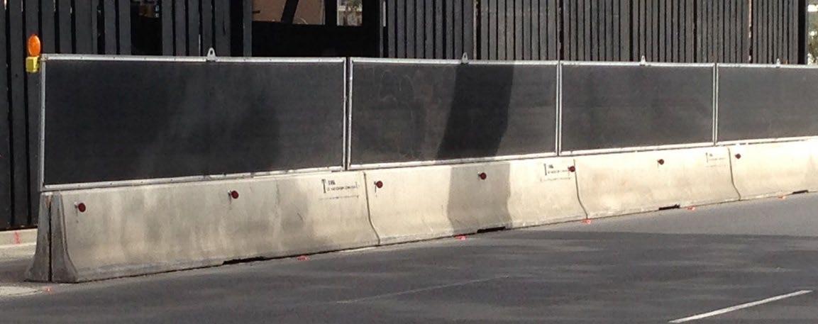
Figure 6.1: Example of Mesh Construction Fencing on lower Queen Street
Figure 6.2: Example of Concrete Safety Barriers topped with Mesh Fencing
6.3.2.1
Design Elements
Project hoardings shall be designed so that they are legible when viewed from a distance and appropriately respond to the context in which they are located i.e. facing traffic lanes or pedestrian environments. The design of Project hoardings should incorporate the key design elements of effective signage outlined in Section 8.3.3 of this DWP to the extent practicable. In particular, hoardings should integrate aspects such as Project branding, graphic design, colour and font so there a similar look and feel for all hoarding and wayfinding information from the street to the Britomart Station
The design of hoardings fronting traffic lanes will be agreed with AT and the Corridor Access Request (CAR) team through the CAR process. These hoardings will be designed in a way that takes suitable account of amenity and traffic management issues.
6.3.2.2
Project Information
Project information displayed on hoarding will:
• Feature the 0800 CRL TALK (275 8255) Project hotline that will be operational 24 hours a day; 7 days a week for any Project related queries or complaints;
• Promote the CRL website and Facebook page;
• Identify the Project Delivery Team – Downer Soletanche Bachy Joint Venture and that the Project is being undertaken by CRLL; and
• Provide the public with Project information, such as an overview of the Project, project benefits, and key information to showcase the Project and communicate the construction story, as appropriate.
Indicative examples of how Project information will be displayed on hoardings around the Project area, are shown in Figures 6.4 – 6.6.

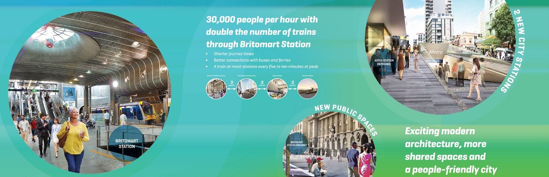
Figure 6.3: Indicative Hoarding Design – Project Benefits
Figure 6.4: Indicative Hoarding Design – Project Information and Images

6.3.2.3
Operational Business Signage
Hoardings may be used to assist some businesses located within or adjacent to the Project area, by displaying key messages related to the operation of these businesses during the construction phasesuch as advising the public that businesses remain in operation, and/or direct visitors to the building entrance during the construction works.
Figure 6.6 provides an example of such signage.
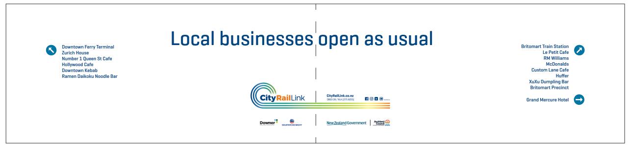
CRLL will engage with Cooper and Company on the design of any signage required in relation to the Britomart Precinct.
6.3.2.4
Advertising Space
Some hoarding space may be made available for general advertising opportunities, such as during the Lower Queen Street Public Activation phase. All general advertising will need to be consistent with the hoarding design principles outlined in Section 6.2 of this DWP to the extent practicable
6.3.2.5
Mana Whenua Involvement
Mana whenua are invited to contribute content to be displayed on Project hoardings. For the Albert Street stormwater main hoardings, mana whenua have contributed to the display of iwi names and logos and a description of the seven Te Aranga design principles with tohu (illustrations) for each one.
Figure 6 5: Indicative Hoarding Design – Project Contact Details and Delivery Team
Figure 6 6: Indicative Hoarding Design – Continued Business Operations
6.3.2.6
Viewing Opportunities
Where practicable and secure, public viewing screens or windows shall be incorporated into Project hoardings. Viewing windows can be any shape or height up to eye level. Windows at a lower height allow children and those in wheelchairs to view the construction activity.
7 Crime Prevention Through Environmental Design
Crime Prevention through Environmental Design (CPTED) is a crime prevention philosophy based on good design and effective use of the built environment in order to reduce the incidence and fear of crime, along with fostering positive interaction amongst users of space.
7.1 CPTED Principles
The principles of CPTED will be incorporated throughout the design and construction of the temporary station accommodation and the CSAs. The key principles that will be adopted in relation to the temporary accommodation buildings, the public realm and around each of the construction sites are as follows:
1 Surveillance – people are present and can see what is going on.
2 Access management and control– methods are used to attract people and vehicles to some places and restrict them from others.
3 Territorial reinforcement – clear boundaries encourage community ‘ownership’ of the space.
4 Quality environments – good quality, well maintained places attract people and support surveillance.
7.1.1 Qualities of Safer Places
The National Guidelines for Crime Prevention through Environmental Design, prepared under the auspices of the New Zealand Urban Design Protocol, define the seven qualities that characterise well designed, safer places. These are as follows:
1 Access: Safe movement and connections
Places with well-defined routes, spaces and entrances that provide for convenient and safe movement without compromising security.
2 Surveillance and sightlines: See and be seen
Places where all publicly accessible spaces are overlooked, and clear sightlines and good lighting provide maximum visibility.
3 Layout: Clear and logical orientation
Places laid out to discourage crime, enhance perception of safety and help orientation and wayfinding.
4 Activity mix: Eyes on the street
Places where the level of human activity is appropriate to the location and creates a reduced risk of crime and a sense of safety at all times by promoting a compatible mix of uses and increased use of public spaces.
5 Sense of ownership: Showing a space is cared for
Places that promote a sense of ownership, respect, territorial responsibility and community.
6 Quality environments: Well designed, managed and maintained environments
Places that provide a quality environment and are designed with management and maintenance in mind to discourage crime and promote community safety in the present and the future.
7 Physical protection: Using active security measures
Places that include necessary, well designed security features and elements.
7.2
7.2.1
Implementation of Best Practice
CPTED Design Elements for the Temporary Accommodation and Construction Areas
CPTED Assessments
To inform the design of the temporary station accommodation and above ground structures, in particular the CSAs and hoardings, CPTED Assessments have been prepared by Auckland Transport’s Principal Specialist - Urban Design, Duncan Rothwell, who holds an Advanced CPTED qualification awarded by the International Security Management and Crime Prevention Institute. The assessments, which are as follows, are provided in Appendix C to this DWP:
• Crime Prevention through Environmental Design Guidelines for Construction Sites - CRL, dated August 2015;
• Memorandum – City Rail Link – Revised Plans for the Britomart Temporary and Permanent Works, dated April 2016 (prepared as part of a CPTED Assessment of key revisions to the Temporary Station Accommodation design); and
• Assessment of Crime Prevention through Environmental Design Issues for the Construction Phases at Britomart – CRL, dated April 2016.
Appendix C also contains AT’s response to the recommendations made in the CPTED assessments, including how the recommendations have been implemented in the design process where relevant
7.2.2 Implementation of CPTED Design Elements
This section draws upon the CPTED Assessments undertaken for the Project and outlines how some of the key CPTED principles and design elements will be implemented in the design of the temporary accommodation in Station Plaza and construction areas with a public interface (refer to the CPTED Assessments provided at Appendix C for full details)
Natural
Access Control
• Limit access to vulnerable surfaces, like glass and painted finishes, with a high level of vandal resistance/ graffiti proofing. In particular, all Project hoardings will be protected with graffiti guard to minimise the potential for vandalism of hoardings during the construction works The amount of blank “white” space on hoardings will be limited through the use of visual images and Project information in order to discourage graffiti (refer to Section 6 of this DWP for more information on hoarding design).
• Limit climbing and access opportunities by setting back fencing/hoardings from existing buildings and infrastructure (poles, street furniture, bus shelters etc.).
• Avoid ‘dead end’ layouts and routes that could provide potential entrapment opportunities. The edges of hoardings will be chamfered in order to improve outward visibility and reduce the potential for concealment and entrapment.
Natural
surveillance
• Provide unobstructed sightlines along pedestrian routes by making them straight, wide and as short as possible. As part of the Project, existing bus canopies will be removed along Tyler, Galway and Lower Queen Street in order to improve visibility and sightlines along these key pedestrian routes.
• Visibility ‘splays’ and avoiding sharp corners of hoarding/noise walls where pedestrian routes intersect building entrances, cross-streets and site accesses can maximise pedestrian sightlines. As mentioned above, all hoardings will have chamfered corners to reduce concealment spots and improve outward visibility
• Avoid concealment and entrapment opportunities in layout and routes.
• Provision of good and consistent levels of white lighting along all public routes New external lighting will be provided on the temporary station accommodation buildings to assist with lighting the public realm adjacent to the Station.
• Activation of building edges facing the public realm. A retail unit will be integrated into the southern accommodation block, fronting Galway Street. The unit will be transparent to Galway Street and to the entry corner adjacent to the Glasshouse, for enhanced visibility and activation of the corner.
• CCTV coverage of the public realm. New CCTV cameras will be installed both internally and externally to the temporary station accommodation to provide enhanced coverage of the public realm around the Station. Refer to drawing ‘Britomart Station Communication Systems, Temporary Works, SISS Arrangement – Ground Level’ and the ‘Britomart Streetscape CCTV Plan’ provided in Appendix C of this DWP. The CCTV cameras are monitored by the Main Control Room within the Britomart Station, which is occupied 24 hours a day.
• Provide a good and consistent level of lighting along all pedestrian routes. All plywood Project hoardings will be illuminated with lights, which will serve to enhance lighting along key pedestrian routes through the area.
Territorial Reinforcement
• Clearly define and designate areas with respect to their intended use, e.g. ensure clear signage for no public access. Station signage will define publically accessible areas within the Station, while Project signage and hoardings will define public access around the construction area.
• Clear Project signage on all construction gates to clearly define vehicular traffic access, along with clear signage of general vehicle lanes through the Project area
• Incorporate visual design material to communicate the construction ‘story’. As outlined in Section 6 of this DWP, Project hoardings will include visual design material to provide Project information and communicate the Project story to the public.
Quality Environments
• Use new materials and maintain regularly, including the removal of graffiti. Refer to Section 5.3.1 of this DWP for further information on graffiti management
• Replace materials if damaged irreparably.
• Refinish defaced surfaces immediately if vandalised.
• Public pedestrian routes shall be clean and maintained regularly to ensure they are free from rubbish and neat and tidy.
8 Wayfinding
The layout or structure of a place (how buildings, spaces, uses, activities and circulation relate to one another) affects its safety and the perception of safety. The legibility of a place, being the ability of the environment to communicate a sense of place and give messages about orientation and direction, is of key importance.
A safe and legible urban structure has a well-defined and clearly understood movement framework and good quality, highly-used public spaces that support surveillance. Pedestrians need well-lit and clearly defined routes linking areas of activity and key destinations. A legible layout lessens the need to depend on signs to find one’s way around. It enables people to read their surroundings and the way ahead in order to detect dangers and warning signs.
During construction of the Project, a range of wayfinding measures will be provided to assist pedestrians with safe and secure movement through the public realm adjacent to Station Plaza and the CSAs. Wayfinding will be provided through a number of measures:
• Design and built form of the Station Plaza temporary accommodation buildings;
• Streetscape changes;
• Wayfinding signage; and
• The presence of AT Ambassadors
8.1 Built Form
The design and built form of the Station Plaza temporary accommodation buildings will assist with wayfinding around the adjacent public realm as follows:
• The buildings are orientated to the line formed by the existing Glasshouse and vent buildings on the Station Plaza, parallel to the north and south facing Tyler and Galway Streets. Facing Commerce Street the orientation is parallel to the kerb, the frontage aligns to the front faces of the two Station Plaza vent buildings.
• The Commerce Street entrance aligns with the Te Ara Tahuhu axis.
• Pedestrian pathways along the Commerce Street building frontage and via Tyler and Galway streets will be maintained during the works, in order to provide for pedestrian movement through the Project area, including to and from the temporary station entrance.
• The Commerce Street frontage uses transparent cladding in a vertical orientation with visible vertical structure.
8.2 Public Realm Changes
Prior to the commencement of the Project, CRLL will undertake a number of activities to facilitate and support the Project. These include:
• The second phase of CBD bus changes 4, which will include the removal of bus services and shelters from lower Queen Street, Tyler Street and Galway Street, along with changes to bus services and stops in Commerce Street; and
• Changes to the streetscapes at the rear of the BTC, specifically widening of footpaths and kerbside management of the adjacent sections of Tyler Street, Commerce Street and Galway Street.
4 The first phase removed scheduled bus services from Albert Street north of Victoria Street as of Sunday 18 October 2015
8.2.1
CBD Bus Changes
To inform the public and bus patrons of the second phase of CBD bus changes, AT will be installing wayfinding signage at all affected bus stops in the CBD advising patrons of the bus stop changes, the location of their new bus stop, along with the date that the changes come into effect. This signage will remain in place until one month after the change is effective. Signage adopts the CRL ‘the build is ON!’ branding.
8.2.2
Streetscape Design
The following specific measures will be implemented as part of the Britomart Streetscape changes to prioritise or otherwise improve the amenity, safety, wayfinding measures and capacity of the pedestrian environment adjacent to the BTC:
• Footpath widening along a section of Galway Street in order to increase the footpath width to approximately 4.5 metres. This will serve to indicate to pedestrians that Galway Street is a key pedestrian route between the temporary station entrance in Commerce Street and Queen Street (and vice versa). The footpath widening will also serve to make this section of Galway Street more attractive to pedestrians and catering for increased pedestrian flows
• A new signalised pedestrian crossing mid-way along Commerce Street to safely manage pedestrian movement between the new BTC station entrance and the Te Ara Tahuhu axis, general and construction traffic. The location of the crossing aligns with the main entrance to the temporary accommodation in Station Plaza and the Te Ara Tahuhu walkway.
• Installation of two new zebra crossings on Galway Street, one of which will be on a speed table as this will be the main pedestrian demand, to safely manage pedestrian movement to and from the temporary accommodation entrances on Galway Street and Commerce Street.
• One new zebra crossing on Tyler Street to safely manage pedestrian movement to and from the temporary accommodation entrances on Tyler Street and Commerce Street.
Refer to the Streetscape Drawings provided in Appendix D and the Project Transport, Access and Parking DWP for more information around the BTC Streetscape changes.
8.3 Signage
8.3.1
BTC Signage
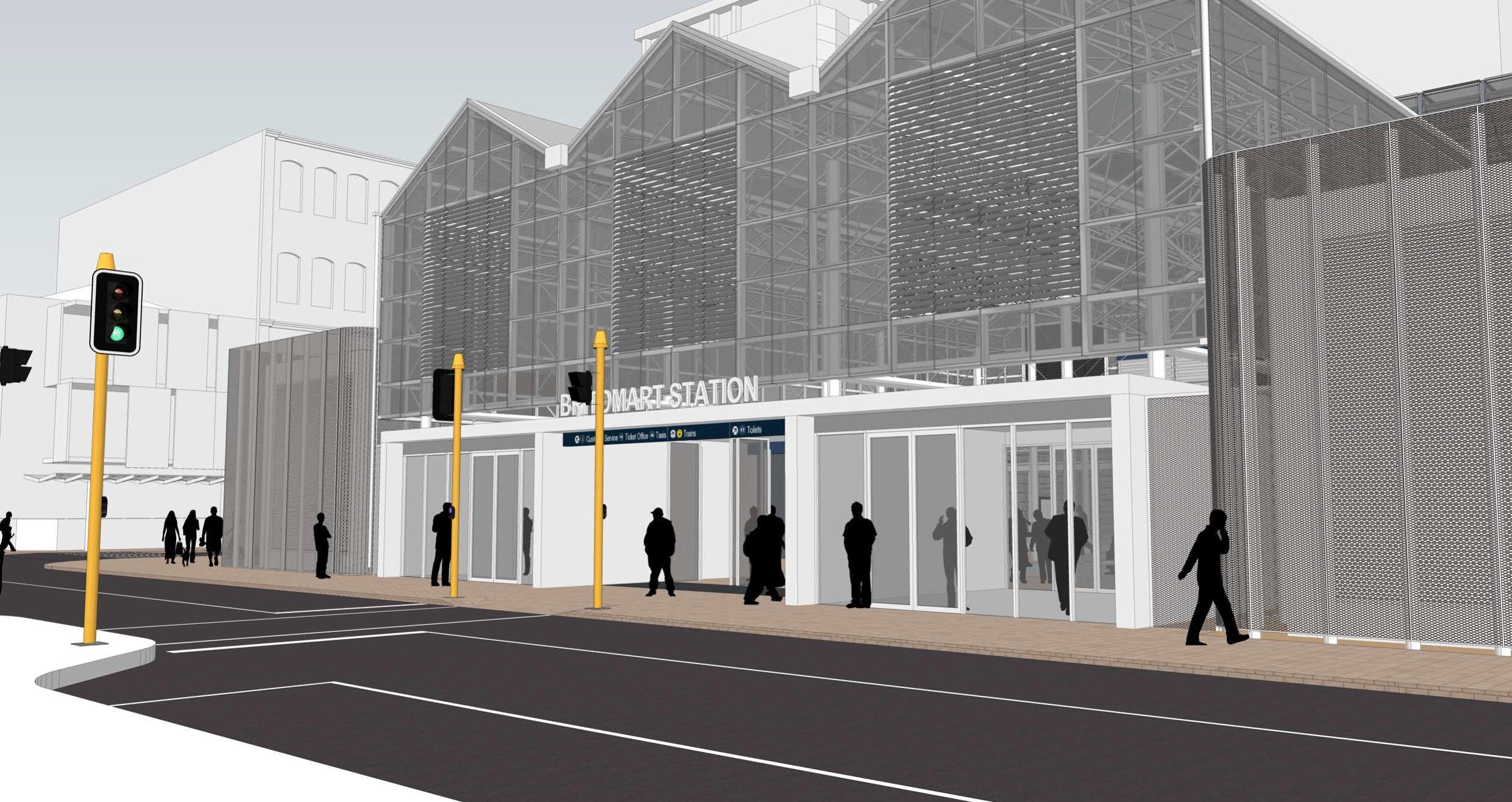
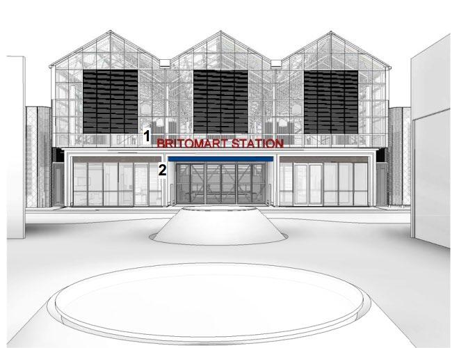
The main entrance to the BTC, through the temporary accommodation in Station Plaza on Commerce Street, will be defined by a highly visible ‘Britomart Station’ sign that is easily readable for users. It is likely that the sign will comprise cut out Illuminated letters mounted on parapet, the colour of which is to be confirmed (refer to Figure 8.1).
Similarly, the side entrances to BTC on Galway and Tyler Streets will also be defined by highly visible entrance signs.
Comprehensive wayfinding signage will also be installed within the BTC to assist rail passengers with legibility and wayfinding through the station (refer Figure 8.2).
8.3.2 Public Realm Signage
Wayfinding signage will be installed at key locations around the Project area and within the surrounding area to move and direct the public to the new BTC entrance in Station Plaza, key public transport facilities and through the Britomart area. As part of the wayfinding strategy to be implemented during the Project:
• Wayfinding signs will be installed at key decision points on the major approach routes, or transitional areas around the Project area, in order to reassure the public and rail passengers that they are on the correct route (refer to Figure 8.3 for indicative primary wayfinding signage locations).
• Wayfinding signage will be installed between key public transport facilities (trains, ferries, and key bus routes (Northern Express) to assist in guiding the public with where they need to go.
• Signage will inform rail patrons as to the location of the new BTC entrances through the temporary accommodation in Station Plaza.
• Wayfinding signage will include directional information, maps and symbols/pictograms as appropriate to the signage typology, purpose and location.
Figure 8 1: Indicative BTC Entrance Signage
Figure 8 2: BTC Wayfinding Signage
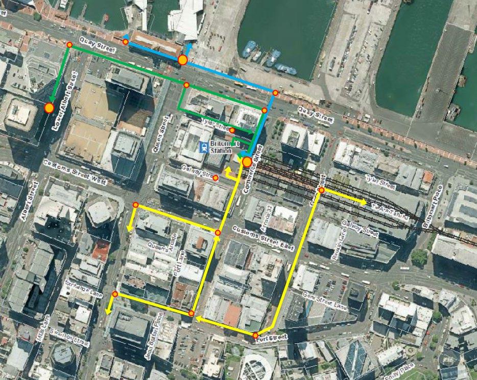
Figure 8.3 notes:
• The blue line would direct pedestrians between the BTC and Ferry Terminal
• The green line would direct pedestrians between the BTC and the main Northern Express bus stop
• The yellow lines would direct pedestrians between the BTC main entrance and the Takutai Atrium entrance and Queen Street, Commerce Street and Gore Street
Wayfinding signage will be incorporated on hoardings around the Project area, particularly at key decision points on Lower Queen Street, and along Tyler and Galway Streets. Wayfinding signage will also be attached to lamp posts or other appropriate structures within the public realm, or comprise free-standing signage in appropriate locations.
8.3.3 Signage Design
The Project’s wayfinding and branding strategy will be confirmed with AT prior to the commencement of the Project.
The design of wayfinding signs shall be in accordance with AT’s wayfinding guidelines to ensure that they are legible when viewed from a distance and appropriately respond to the context in which they are located i.e. facing traffic lanes or pedestrian environments. The following elements shall be considered in the design of wayfinding signage:
• Standardised message design i.e. suitable font style and spacing between letters and words;
Figure 8 3: Indicative wayfinding routes and primary sign locations
• Message legibility, considering the information from the perspective of a variety of users;
• Consistency in sign types and design in order to assist the public to identify and recognise Project wayfinding signage;
• Provision for safe universal access through the public realm;
• Colour contrast on the sign using a suitable colour palate;
• Luminance contrast between the background and the letters and graphics;
• Clear definition of buildings, roads, pathways, and other built elements, such as landmarks or prominent site features;
• Sufficient detail of the building form or layout, maintaining the hierarchy of form and layout;
• Informative content providing unambiguous directions;
• Avoid reflective surfaces which will hinder visibility and comprehension;
• Position lighting to reduce glare on signage with reflective surfaces; and
• The wording of wayfinding signage fronting traffic lanes will be agreed with AT and the CAR team through the CAR process.
Examples of wayfinding signage and branding are provided by Figure 8 4
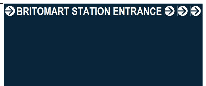
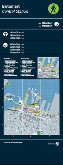
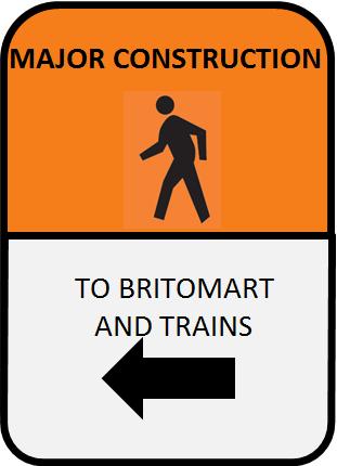
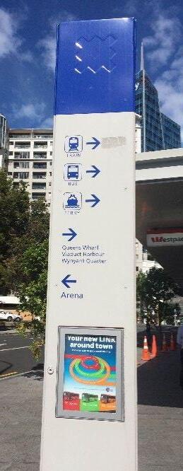
Figure 8 4: Examples of wayfinding signage
CRLL will engage with Cooper and Company on the design of wayfinding signage in relation to the Britomart Precinct.
8.3.4 Footpath Guidance
Temporary coloured markings will be used as footpath pedestrian guidance lines between key public transport facilities (i.e. BTC and the ferry terminal) and along key pedestrian routes, such as Queen Street, Commerce Street (refer to Figure 8.3).
The coloured markings will be specific to the individual routes and will also comprise symbols/pictograms of the relevant public transport (train, bus, ferry) and directional wording.
8.4 AT Ambassadors
During the changeover of the BTC station entrance from Lower Queen Street to via the temporary station accommodation, AT Ambassadors will be positioned at key locations and decision points around the Britomart public realm and adjacent areas, in order to assist rail patrons and the public with wayfinding through the pedestrian environment
9 Reinstatement
In accordance with BTC designation Condition 3.2, the Station Plaza accommodation shall be removed within one year of the completion of the Project works. As outlined in Section 2 of this DWP, Stage 4 of the Project will involve reinstating the Station Plaza and Construction Support Areas A and C. Reinstatement will be:
(a) To the same or better standard that existed prior to the Project works being undertaken; and
(b) In a manner that is coherent within the wider area and/or recent public realm upgrades in the area.
CRLL is preparing an Urban Design DWP that will outline the permanent public realm design for the streetscape and public areas around the Project area, including providing additional detail on reinstatement of the Station Plaza area and Construction Support Areas That Urban Design DWP will be provided to Auckland Council at a later date.
10 Review and Updating of the
DWP
This Urban Design DWP has undergone a review process with the Project Community Liaison Group (CLG) and a suitably qualified Independent Peer Reviewer. An explanation of how any comments from the CLG and Independent Peer Reviewer have been incorporated into the Urban Design DWP is provided in Appendix E.
10.1 DWP Review
This DWP will be reviewed throughout the course of the Project:
a To reflect material changes associated with changes to construction methods or unresolved complaints; and
b As part of the annual management review of the DWP.
The management review of this DWP will be undertaken by the Project Management team and the CRLL representatives. The management review will be organised by the Environmental and Sustainability Manager and the Project team will be informed of any changes to this DWP through the regular Project communications processes. The review will take into consideration:
• Compliance with the designation or consent conditions, the CEMP, DWPs and EMPs (including site specific plans) and material changes to these plans.
• Any significant changes to construction activities or methods.
• Key changes to roles and responsibilities within the Project team.
• Changes in industry best practice standards.
• Changes in legal or other requirements (social and environmental legal requirements, consent conditions, CRLL objectives and relevant policies, plans, standards, specifications and guidelines).
• Results of inspections, monitoring and reporting procedures associated with the management of adverse effects during construction.
• Comments or recommendations from Auckland Council regarding the CEMP and DWPs.
• Unresolved complaints and any response to complaints and remedial action taken to address the complaint.
10.2 DWP Updates
The process for updating this Urban Design DWP as a result of a material change to the Project or the annual review, is as follows (refer to BTC designation Condition 22 for further information):
• Any material change to this DWP must be consistent with the purpose and objective of the relevant conditions listed in Table 1.1 of this document.
• Affected parties and the CLG must be notified of the review and any material change proposed to this DWP.
• This DWP must clearly document the comments and inputs received from affected parties in relation to any material changes, along with a clear explanation of where any comments have not been incorporated, and the reasons why not.
• Any material change proposed to this DWP relating to an adverse effect shall be submitted for approval to Auckland Council Compliance and Monitoring Officer and the Auckland Design Office, at least 10 working days prior to the proposed changes taking effect. If any changes are not agreed, the relevant provisions of the RMA relating to approval of outline plans shall apply.
A copy of the original Urban Design DWP document and subsequent versions will be kept for the Project records, and marked as obsolete. Each new / updated version of the Urban Design DWP documentation will be issued with a version number and date to eliminate obsolete Urban Design DWP documentation being used.
A summary of the review process will be provided annually to Auckland Council and otherwise be made available on request.
A copy of the original Urban Design DWP document and subsequent versions will be kept for the Project records, and marked as obsolete. Each new or updated version of the Urban Design DWP documentation will be issued with a version number and date to eliminate obsolete Urban Design DWP documentation being used.
11 Management and Control of Documents
All project documentation is created, reviewed, approved, issued, revised, retained, and superseded in accordance with the project’s Document Management & Control Plan, which includes the requirement for records of review and authorisation to be maintained. The following project-specific documents need to be created to support the processes described in this plan:
1. Site Inspection Records
1.1. Weekly E&S site inspection forms
1.2. Monthly E&S site inspection forms
1.3. Night audit site inspection forms
1.4. Corrective action tracking register
2. Annual Review
2.1. Record of review of DWP
Appendix A : Temporary Accommodation
Appendix B : Hoardings Plan
Appendix C : CPTED Assessment
Appendix D : Streetscape Plans
Appendix E : CLG and Peer Review Comments
• Community Liaison Group Comments
Comments received from the CLG are as follows:
Date
5th May 2016 Cooper and Company
5th May 2016 Cooper and Company
Table 1.1 This section outlines the relevant conditions as being condition 33B. Query whether there is also a need to refer to:
• Condition 3.2 which requires the removal of Station Plaza temporary accommodation within 1 year
• Condition 19.2(i) which states that the CEMP must include details of how Station Plaza, Tyler and Galway Streets will be reinstated upon completion
Section 3.3 Describes the public realm behind the CPO.
Query whether this should refer to Cooper and Company being responsible for design, maintenance etc of the public realm with the exclusion of the plaza area? Might be useful to reference the public services agreement at some point in this DWP
5th May 2016 Cooper and Company Figures 4.1 – 4.5 Station Plaza Temporary Accommodation 3D, pages 9, 10 and 12; Figures 7.1 –7.3 – pages 29 and 30; and Appendix A – Temporary Accommodation Plans – Cooper and Company would like to be kept informed of the design plans and any changes to design plans for this area
5th May 2016 Cooper and Company
Section 4.5 notes that the street furniture underneath the canopies on Tyler and Galway Streets will be removed. At the moment only part of the Galway Street canopy has been removed. Can we obtain confirmation of timing for full removal.
Table 1.1 has been updated to include Condition 3.2.
Condition 19.2 relates to details to be addressed in the CEMP, hence it is not relevant to this DWP and not included in Table 1.1.
Section 3.3 updated to refer to the Britomart Precinct Public Areas Agreement
AT will inform Cooper and Company of any changes to the design plans in this regard. As this matter is not appropriate to document in the DWP, no change to DWP.
The Tyler Street canopies and remaining Galway Street canopies will be removed mid – late June 2016.
5th May 2016 Cooper and Company
5th May 2016 Cooper and Company
Section 5.3.1 – Graffiti management – aims to address within 48 hours. Cooper and Company would prefer that this be addressed as soon as possible and within 24 hours rather than 48.
Section 6.3.2.3 sets out an example of how signs could be used to indicate that local businesses are open as usual. Cooper and Company would want to be involved in the design of any signs affecting the Britomart Precinct.
Section 5.3.1 amended to refer to removal within 24 hours
AT will engage with Cooper and Company regarding wayfinding signage design in relation to the Britomart Precinct. Text included in Section 6.3.2.3 and 8.3.3.
5th May 2016 Cooper and Company
5th May 2016 Cooper and Company
Section 9 states that an Urban Design DWP is currently being prepared outlining the permanent public realm design for the streetscape and public areas around the project area. Cooper and Company would like to be involved in initial plan development discussions and also at an early stage in identify the extent of reinstatement required – particularly in relation to the fit-out of the upper levels of the CPO.
Section 10 notes that any material changes to the DWP will require approval from Council.
However it should also note that any material changes also need to be notified to the CLG under condition 8.7.
AT will engage with Cooper and Company regarding preparation of the Urban Design DWP for the permanent public realm design. As this matter is not appropriate to document in this DWP, no change required to the DWP.
20th May 2016 Cooper and Company
20th May 2016 Cooper and Company
Section 3.4 text has a typo “andaccess”. Query whether it would also be helpful to refer to restrictions on buses on these roads too?
General comment, changes are good.
20th May Cooper and Company Bus flyer / plan showing ban on heavy traffic, including buses, on Gore, Galway and Tyler streets to be inserted into plan.
Section 10 updated to refer to CLG notification of material changes
Section 3.4 text updated to correct typo and reference the bus restrictions on Tyler and Galway Streets.
Noted. No updates required.
Include as Figure 3.5 in Section 3.4.
• An Independent Peer Review of the draft Urban Design DWP was undertaken by Henry Crothers from LandLAB Limited, with peer review comments received on 25th May 2016. The comments received are as follows:
Condition Comment
33B.1
a) The proposals for the Station Plaza Accommodation and surrounding streetscape address the functional requirements outlined by the brief. Comments have been provided on specific items for consideration.
b) On completion of the CRL project consideration should be given to establishing Station Plaza as a public space with;
- less car parking spaces in order to provide increased capacity for pedestrian movements
- create a place able to be used and occupied by pedestrians
- revised paving materiality and design features which provide a conceptual fit with Takutai Square and the proposed Lower Queen Street Civic Space
c) Re-instatement works should tie into existing or any proposed streetscape upgrade and/or upgrade of the Station Plaza area
33B.3 i) the proposed pedestrian environment of Tyler, Galway and Commerce Streets is considerably less generous than the existing footpath access to the CPO/Britomart Station from Lower Queen Street/QE Square.
ii) the proposed way finding signage elements and hoardings strategies provide the potential to assist with the creation of a legible and safe streetscape environment. The success of this will be dependant on final detailed designs and locations
iiI) It is important to provide the proposed way finding, place and engagement content on the hoardings. This should be prioritised over frequent use of AT branding or basic project facts available or communicated elsewhere
33B.4 Details of how the Station Plaza and Construction Support Areas A and C will be reinstated upon completion of the Project. These details not provided. On completion of the CRL project consideration should be given to establishing Station Plaza as a public space with;
- less car parking spaces in order to provide increased capacity for pedestrian movements
- create a place able to be used and occupied by pedestrians
Response
Noted.
Response below on specific items.
Noted. A further Urban Design DWP is to be prepared in accordance with the CRL designation condition 47, which will address the permanent public realm urban design for the CRL Project and surrounding landscape. That DWP will be submitted to Auckland Council at a later date and will address these and other matters. It will reinstate Station plaza to the same or better standard.
Noted. The footpath widths and layout have undergone extensive review as part of the design process to address safe public access and provide for safe and efficient traffic movements on the affected streets.
Noted. AT is engaging with local businesses and other stakeholders in the design and location of wayfinding signage.
Noted.
Refer to comment above regarding future Urban Design DWP.
- revised paving materiality and design features which provide a conceptual fit with Takutai Square and the proposed Lower Queen Street Civic Space
33B.4 Public Realm Changes
The design proposal for Galway Street incorporates 2 x Disabled Parking Spaces and 1 x Parking Space and a new raised pedestrian crossing. The following comments are provided;
- consider relocating the Disabled Parking spaces to Tyler Street so passengers can access the Station Plaza area directly rather than crossing Galway Street
- consider narrowing the carriageway further from 3.9m to 3.5m to provide a wider footpath and accessibility for the large numbers of pedestrians anticipated
- consider adjusting the location of proposed the pedestrian crossing to align with pedestrian desire lines from Commerce Street to the Station Plaza Accommodation
- consider whether the proposed parking space is necessary
The design proposal for Tyler Street incorporates 2 x Disabled Parking Spaces and 1 x Parking Space and a new raised pedestrian crossing. The following comments are provided;
- consider re-aligning the proposed pedestrian crossing with desire lines between Quay Street/Commerce Street and the Station Plaza Accommodation
- consider adjusting the kerb line to provide additional footpath space
The design proposal for Commerce Street proposes additional bus stops and parking bays. The following comments are provided;
- review pinch points associated with proposed bus stop locations and the detailed design/location of these stops to provide better pedestrian amenity and avoid congestion
- remove proposed parking bay located between Customs and Galway Street (east side) to avoid creating a pinch point for pedestrians
- consider widening the existing kerb between Tyler and Quay Street (east side) to provide more room for proposed bus stops
33B.4 Streetscape Design
Is there any science behind the proposed 4.5m wide footpath width or is this the best available?
Consider making this wider and narrowing the carriage which is wide (3.9m).
Consider setting the building edge back from the kerb edge between the two existing ventilation shafts to create a more generous interface/threshold zone which can accommodate likely high b
The consideration of parking provisions on affected streets has undergone extensive review during the design develop ment. The disabled car parking locations were selected to avoid cross flows with construction traffic on Tyler and Galway Street s The disabled parking spaces are considered essential for passenger amenity for elderly and disabled users. Ongoing review of need and effectiveness will be undertaken.
Note comments above regarding design development and review process.
number of movements in this area. Will be a combination of people moving and people queuing for the crossing which may lead to congestion.
Review locations of these to support pedestrian desire lines to proposed station entrances.
Review locations of these to support pedestrians desire lines to proposed station entrances.
Appendix F: Register of Plan Updates
• Annual Reviews
Updates Date
Updates have been made to the following sections:
• Section 2.1 – change from sheet piling to secant piling
• Section 6.1 – updates to text to clarify hoardings and fencing types installed for the Project
• Sections 6.3.2.1 – 6.3.2.3 – update to reflect the change to Project hoarding design no longer using the Auckland Transport ‘CRL the Build is On’ branding
• Section 8.3.3 - update to reflect the change to Project hoarding design no longer using the Auckland Transport ‘CRL the Build is On’ branding
• Section 8.3.4 – update to text to refer to wayfinding markings (as opposed to wayfinding line markings)
• Section 11 – new section added to the DWP which identifies the project-specific documents that need to be created to support the processes described in this plan
Updates have been made to the following sections:
• Section 2.1 – update to Table 2.1 to reflect changes to construction programme dates
• Section 6.1 – update to Table 6.1 to reflect changes to construction programme dates, and hence changes to construction fencing durations
• Various sections to change reference from Auckland Transport to City Rail Link Limited where appropriate.
September 2017
August 2018