All rights reserved. Neither the whole nor any part of this paper may be reprinted or reproduced or quoted in any form or by any electronic, mechanical, or other means, now known or here-after invented, including photocopying and recording, or in any information storage or retrieval system, without accompanying full bibliographic listing and reference to its title, authors, publishers, and date, place and medium of publication or access.
Cover photo:
Yosemite National Park, CA (Elizabeth VanDerwerken)
Table of Contents
Foreword
Reading Environmental Principles and Practices
Fritz Steiner
PART 1: Environmental Theorists
Daniel Hudson Burnham - Architect and Urban Planner
Sylvanus Narh Duamor
Patrick Geddes: Visionary Urban Planner and His Enduring Legacy
Hui Tian
Marjorie Sewell Cautley: Landscape Planner for Better Social Life
Lillian Chung Kwan Yu
J. B. Jackson: Vernacular
Suhyun Kim
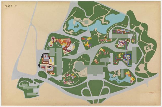
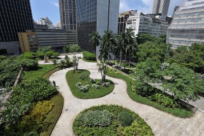
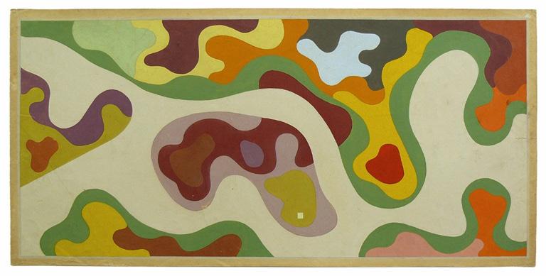
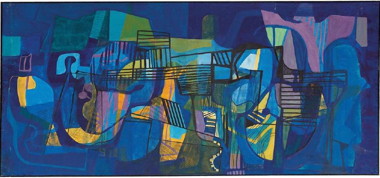
Roberto Burle Marx
Owens
Ian Lennox McHarg
Yuna Baek
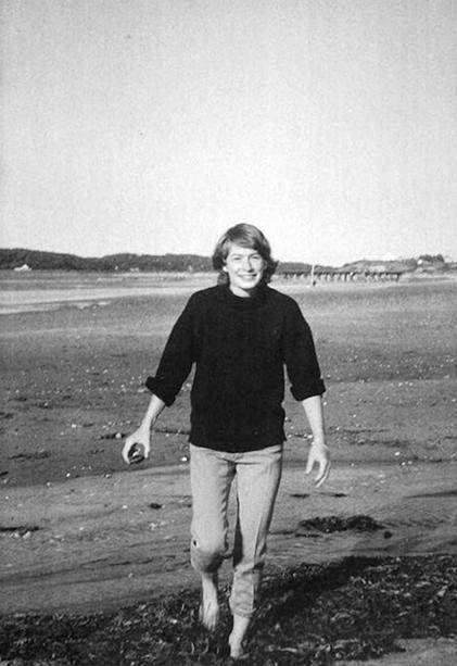
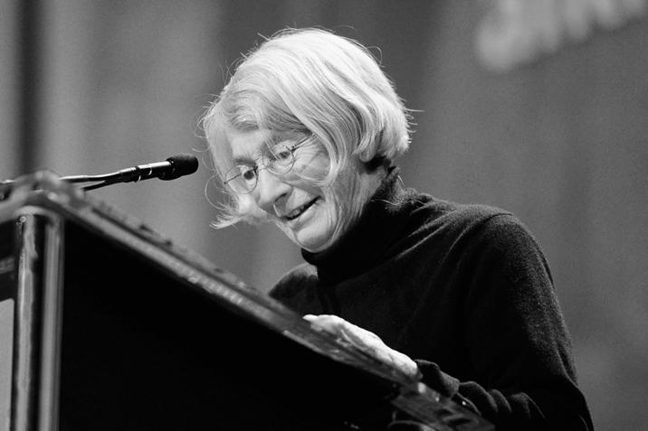
Mary Oliver: Attention As A New Environmental Ethic of Care
Elizabeth VanDerwerken
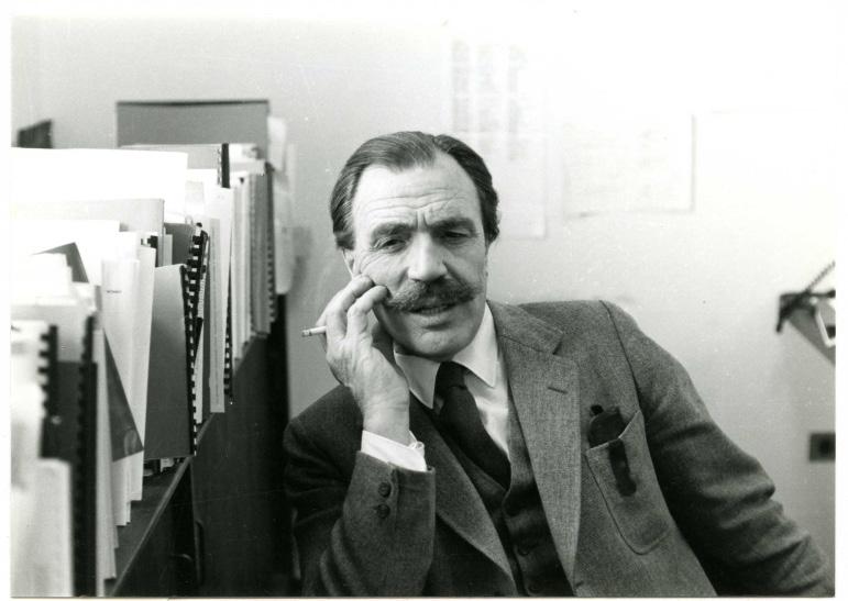
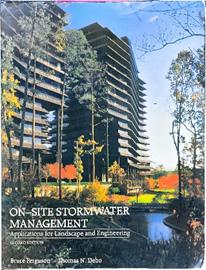
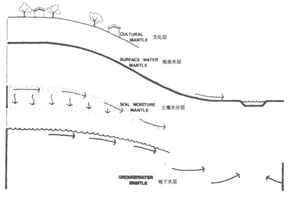
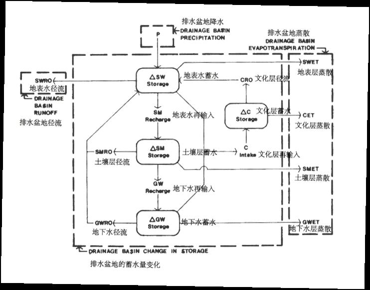
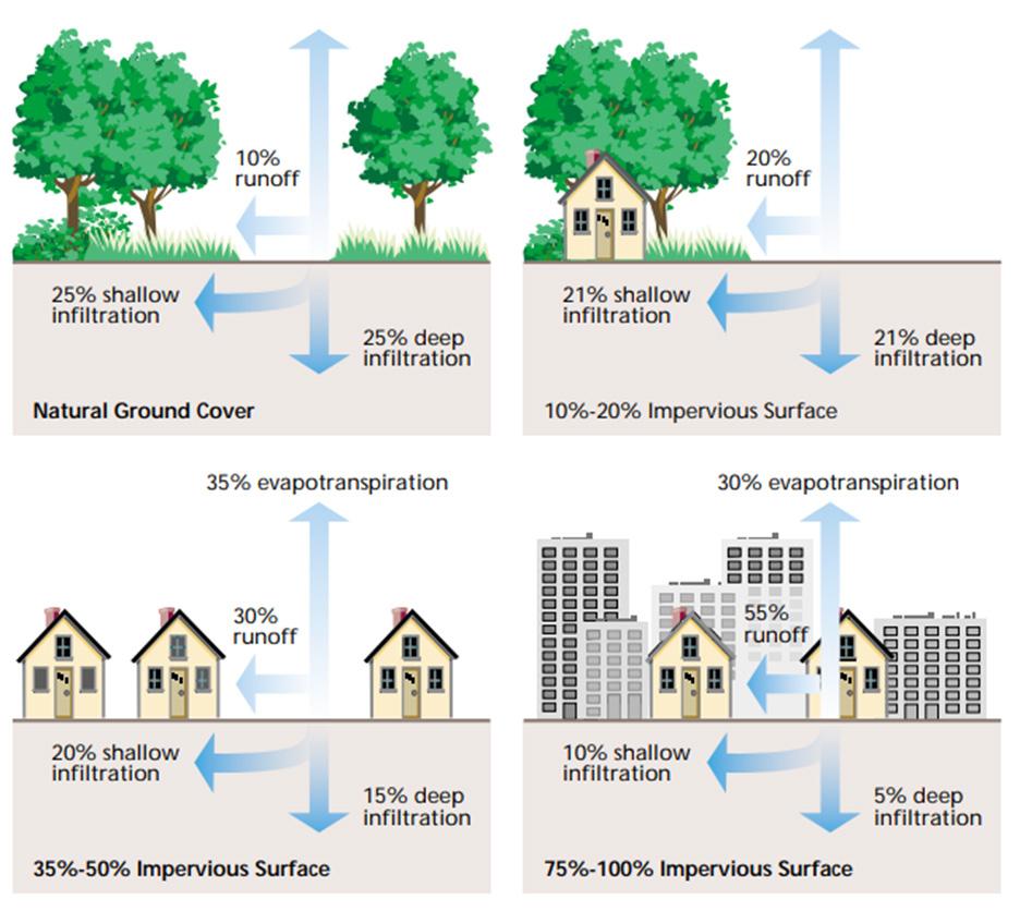
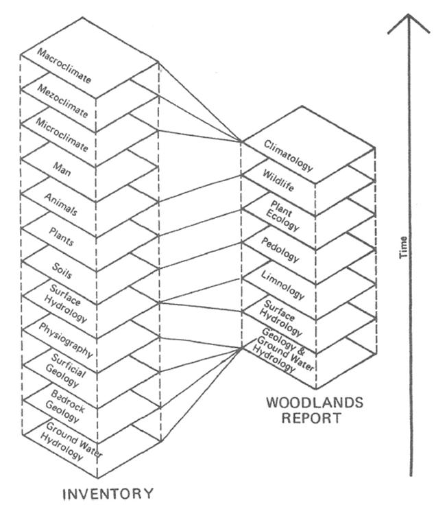
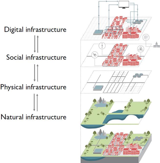
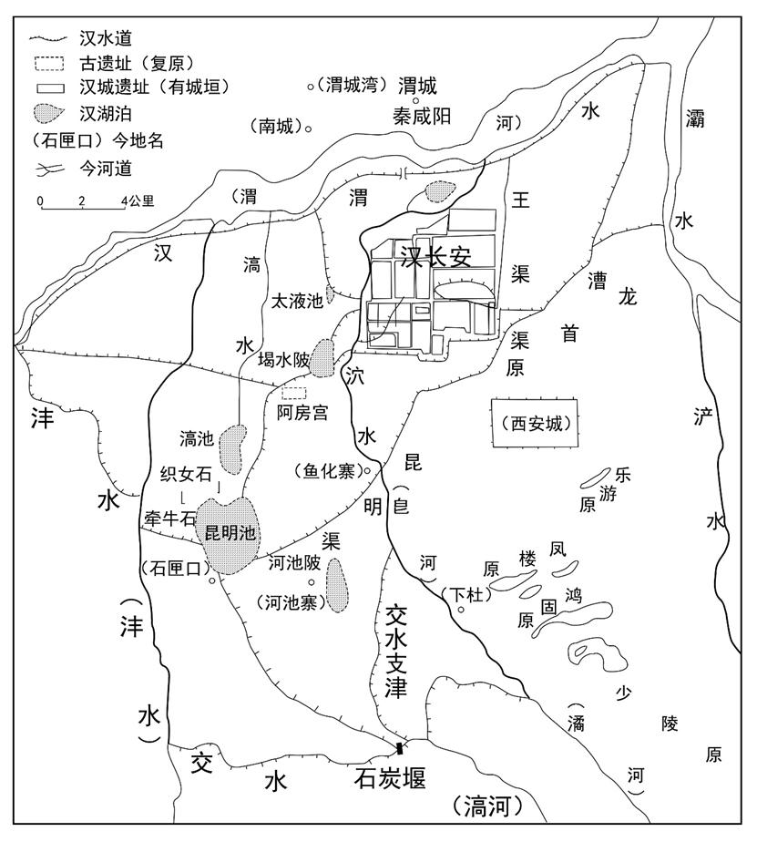
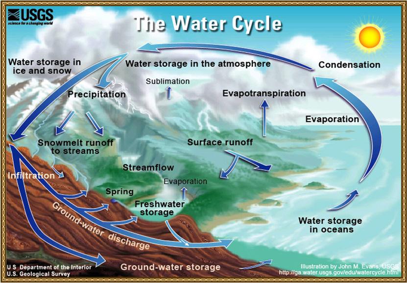
Water Cycle, Layer-Cake Model and Landscape Hydrology: Research About Bruce Ferguson and His Academic Pursuit
Hailong Liu
Roberto Burle Marx: Artist, Ecologist, Environmentalist in Landscape Architecture
Sydney Cleveland
Shaping the Land: Kathryn E. Gustafson’s Practical Theory
Ching-Hao Lin
Thaïsa Way Gabe Weber
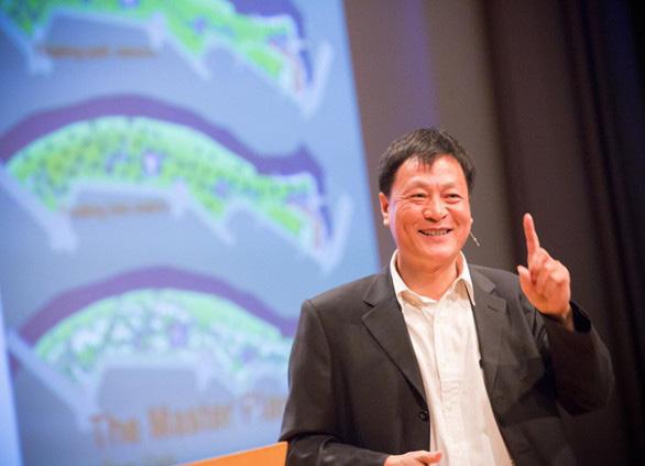
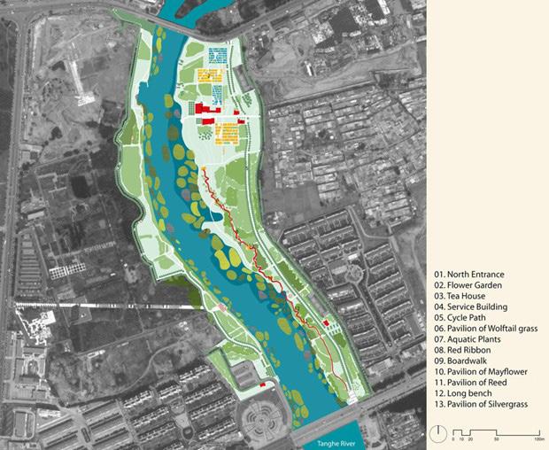
Landscape Architect Kongjian Yu: Ecological Planning in China
Anwen Kelly
PART 2: Examination of Environmental Theories
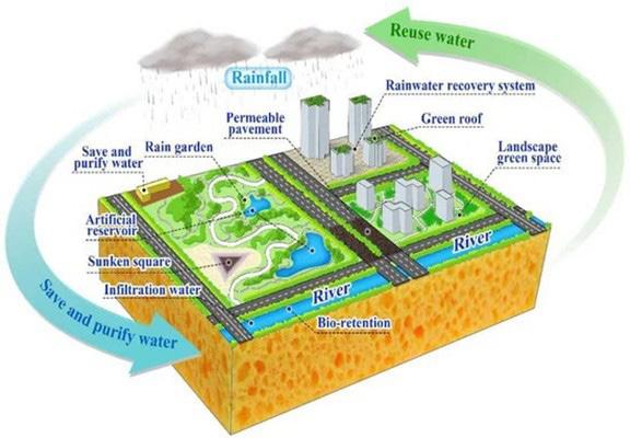
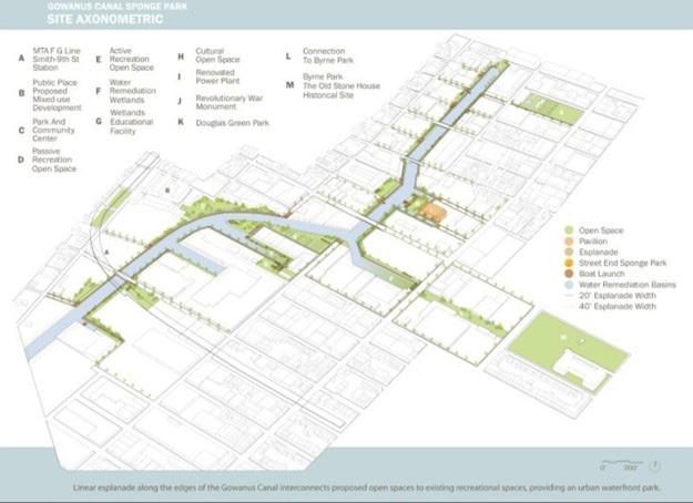
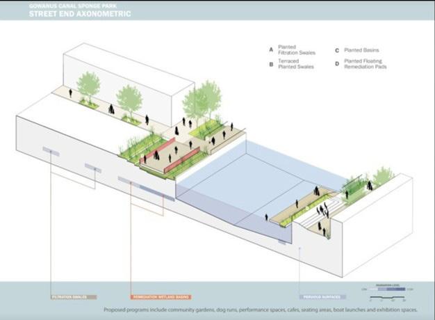
Sponge Theory: Natural Flooding Prevention
Anwen
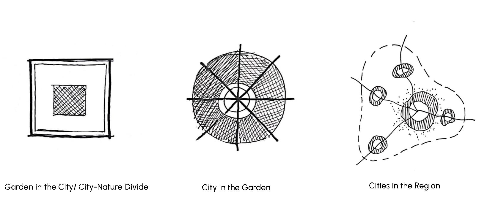
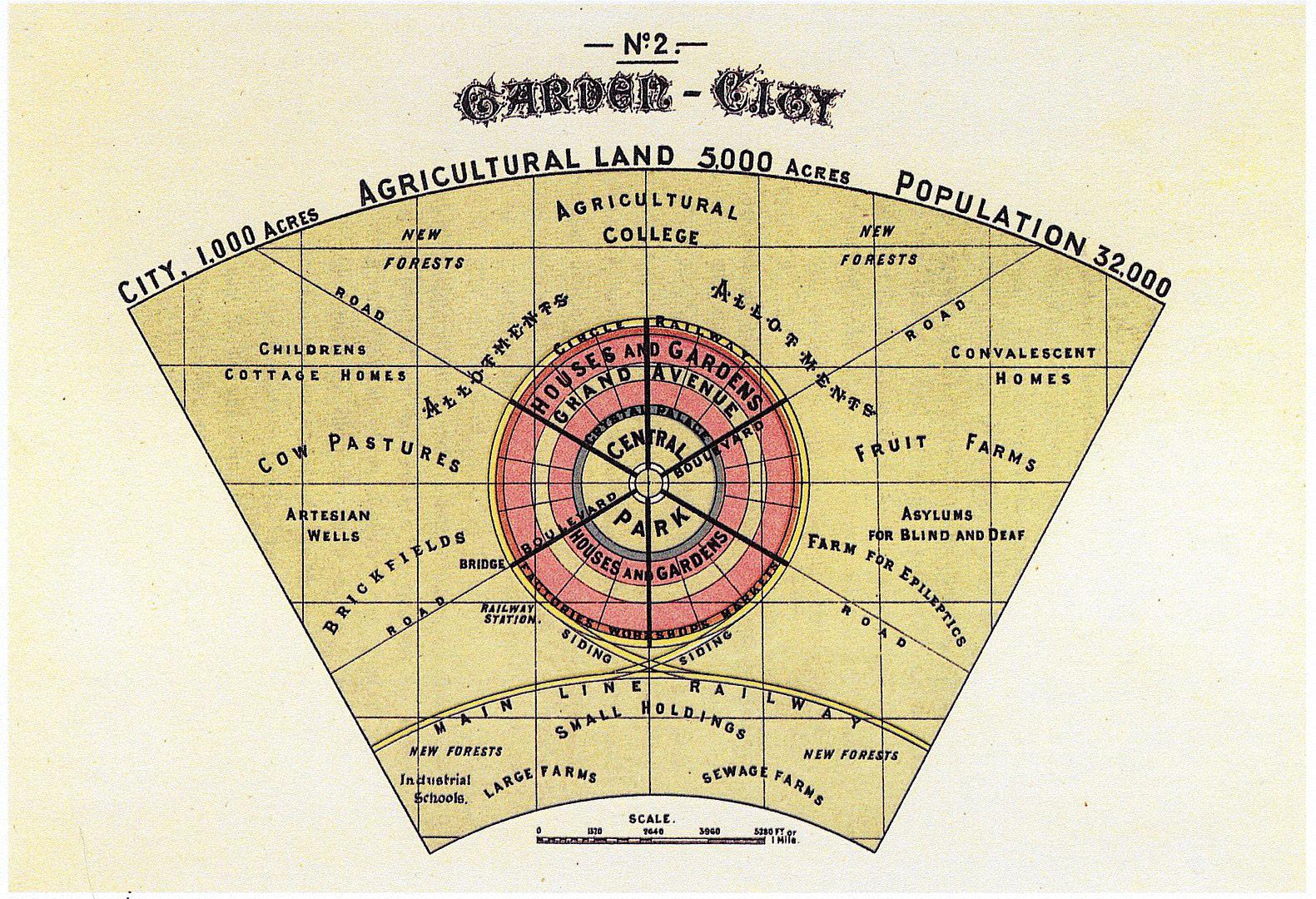
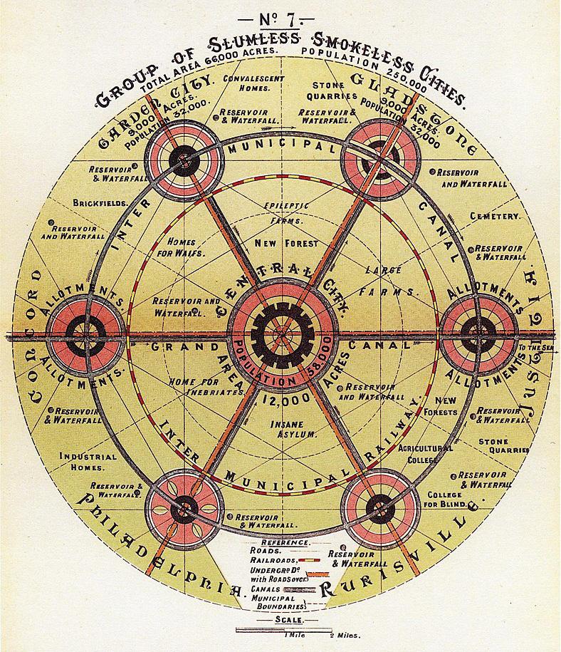
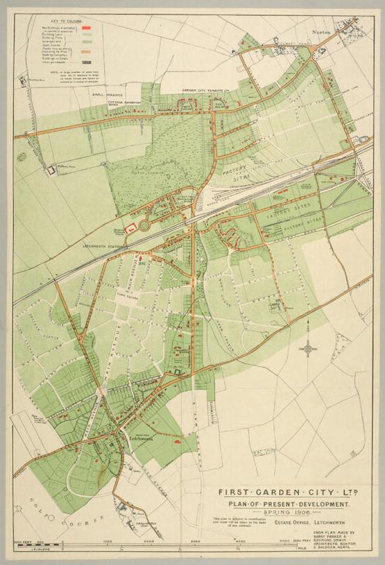
City in a Garden: Historical Lineage of Ebenezer Howard’s Garden City
Urbanism in the 20th Century
lllegible City: Understanding the Thresholds Defined by Kevin Lynch
and Positionings of
PART 3: Emerging Environmental Theories
Language as a Relational Tool: Developing a Lexicon of Place
Elizabeth VanDerwerken 240
A New Theory for Dynamic Urban Environment: Landscape Metabolism
Ching-Hao Lin 248
Toward Ecological Urbanism in Hong Kong: Reframing New Town Planning through Ecological Analogs
Lillian Chung Kwan Yu 254
The Sixth Element: Expanding Kevin Lynch’s Theory of Urban Legibility for Application to Organically Evolved Cities, with a Focus on Seoul
Suhyun Kim 260
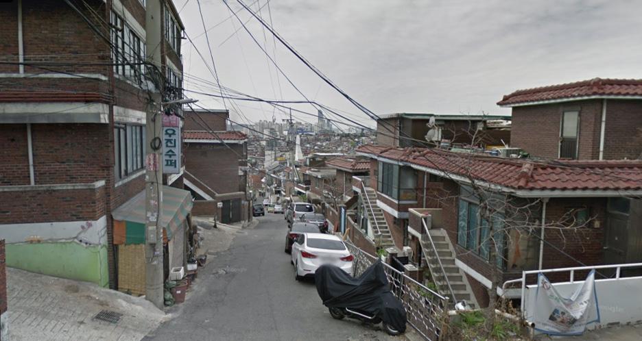
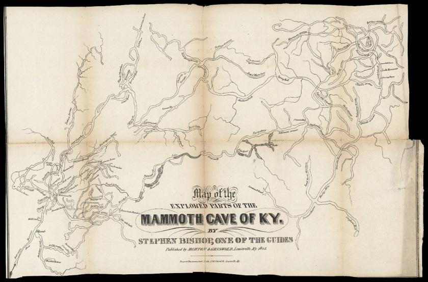
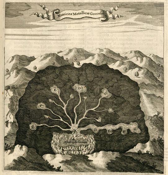
Is Landscape Architecture Underground?
Gabe Weber 265
What Next for Landscape Design?
Sydney Cleveland 273
Ecological Planning Everywhere
Sylvanus Narh Duamor 279
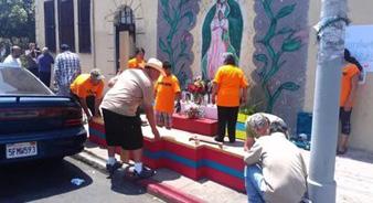
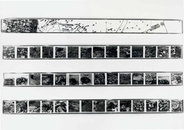
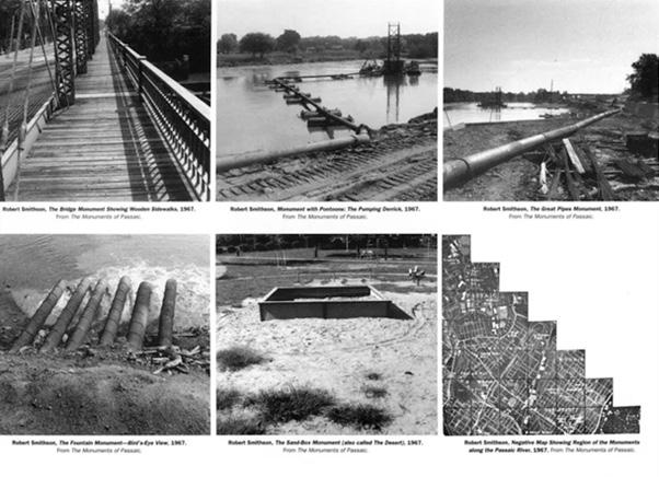
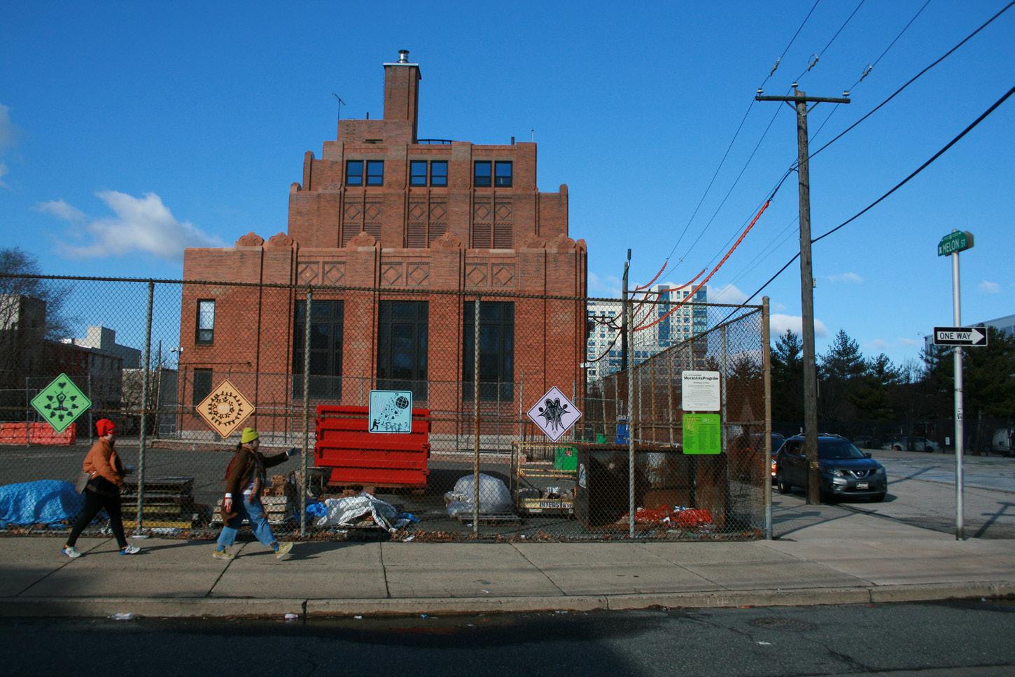
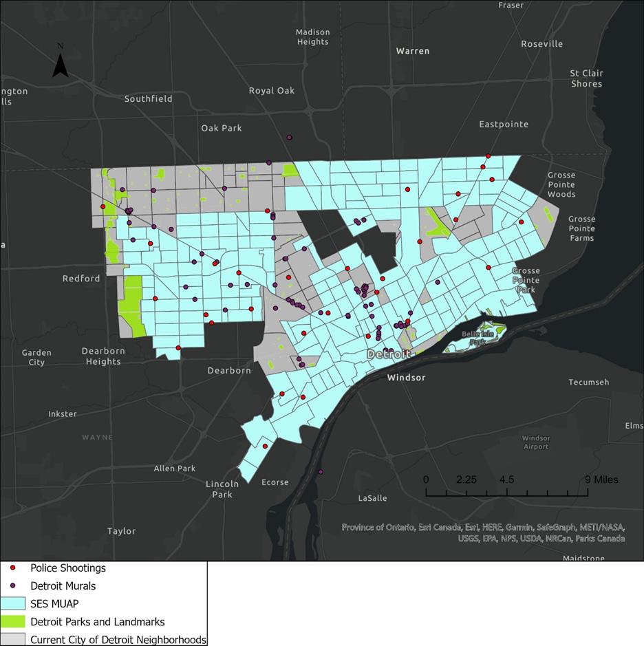
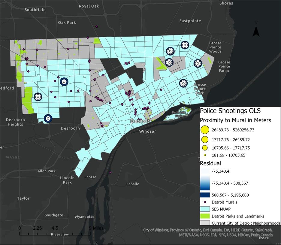
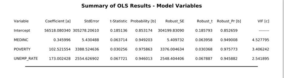
Murals as a Predictor of Territorial Stigmatization
Marcus Owens 289
City Cooling Beauty Theory
Anwen Kelly 300
Rethinking Urban Flood Management Through Multi-Layer Infrastructure
Hui Tian 311
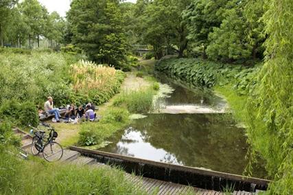
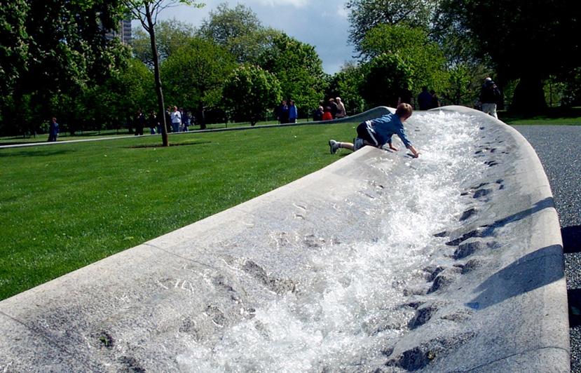
Fountains Beyond Decorative Models
Yuna Baek 320
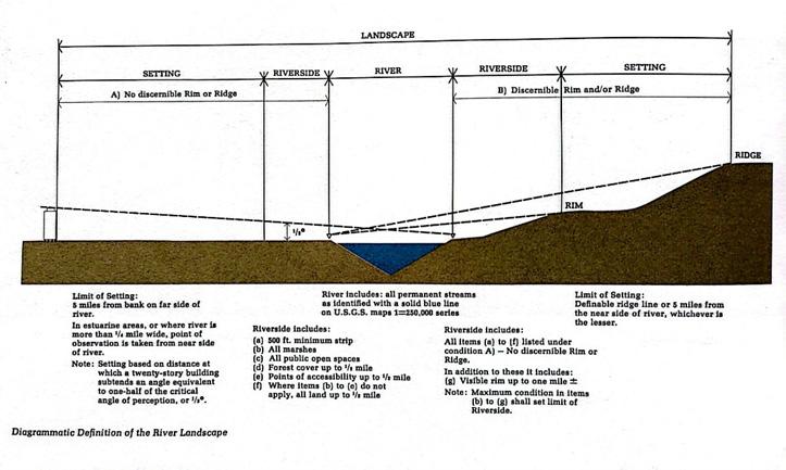
Origin, Necessity, Paradigm and Reflections of Landscape Hydrology
Hailong Liu 324
Contributors
Afterword
Fritz Steiner Foreword
Reading Environmental Principles and Practices
Our principles are our fundamental beliefs. Principles should guide actions including how we plan and design. Transcendentalism was a mid-19th century cultural movement that emphasized the importance of nature in understanding our surroundings. The principles of Transcendentalism influenced designers and planners in the United States, notably Frederick Law Olmsted Sr. He designed Central Park in New York City with Calvert Vaux and established the field of landscape architecture. In many ways, Olmsted also laid the groundwork for city and regional planning in the United States.
Lawrence Buell identified Transcendentalism as a crucial component of the “green thread” in American letters. From the senior Olmsted to the present, the ideas – the theories – from the literature have informed the practices of design and planning. Buell focused his exploration of the green thread mostly on the United States. However, principles about the interactions between nature and culture are present in other nations too.
Understanding and reading landscapes help us apply our principles about nature through our cultural practices. The University of Pennsylvania course, Environmental Readings, is intended to empower students to foster such connections. The course has three parts.
First, we explore the lives of the theorists. People like us are responsible for ideas about the design and planning of built environments. Through learning about their lives, we can be inspired in our own. Students write about a specific theorist of their choice from writer Mary Oliver to landscape historian Thaïsa Way. Second, we examine several ecological design and planning theories. Students then select one of those ideas to probe in greater detail such as green urbanism and sponge cities. In the third part of the course, students are encouraged to articulate their own theory: their own set of principles which will help guide their practices.
Collected here are papers by students in the Spring 2024 and 2025 Environmental Readings classes. In addition to master’s and doctoral students in architecture, city planning, and landscape architecture at Penn’s Stuart Weitzman School of Design, we have had students from earth and environmental science as well as education enrolled. We have also been fortunate to have visiting scholars from China and Turkey auditing the class and making valuable contributions. This the fourth set of Environmental Readings papers to be published. Two previous volumes were compiled at the School of Architecture, University of Texas at Austin. This is the second group from the Weitzman School of Design. The Penn publications are available through our McHarg Center for Urbanism and Ecology.
My goal in supporting this publication is to exhibit the rich diversity of ideas explored by the “environmental readers.” I have had the good fortune to interact with such hopeful and enthusiastic students. I especially value the commitment and attention to detail by the editors of this volume. We hope to show how the green thread of thought continues to advance, evolve, and adapt here in the United States and far beyond.
Note
1. Lawrence Buell. 2001. Writing for an Endangered World: Literature, Culture, and Environment in the U.S. and Beyond. Cambridge, Massachusetts: Harvard University Press.
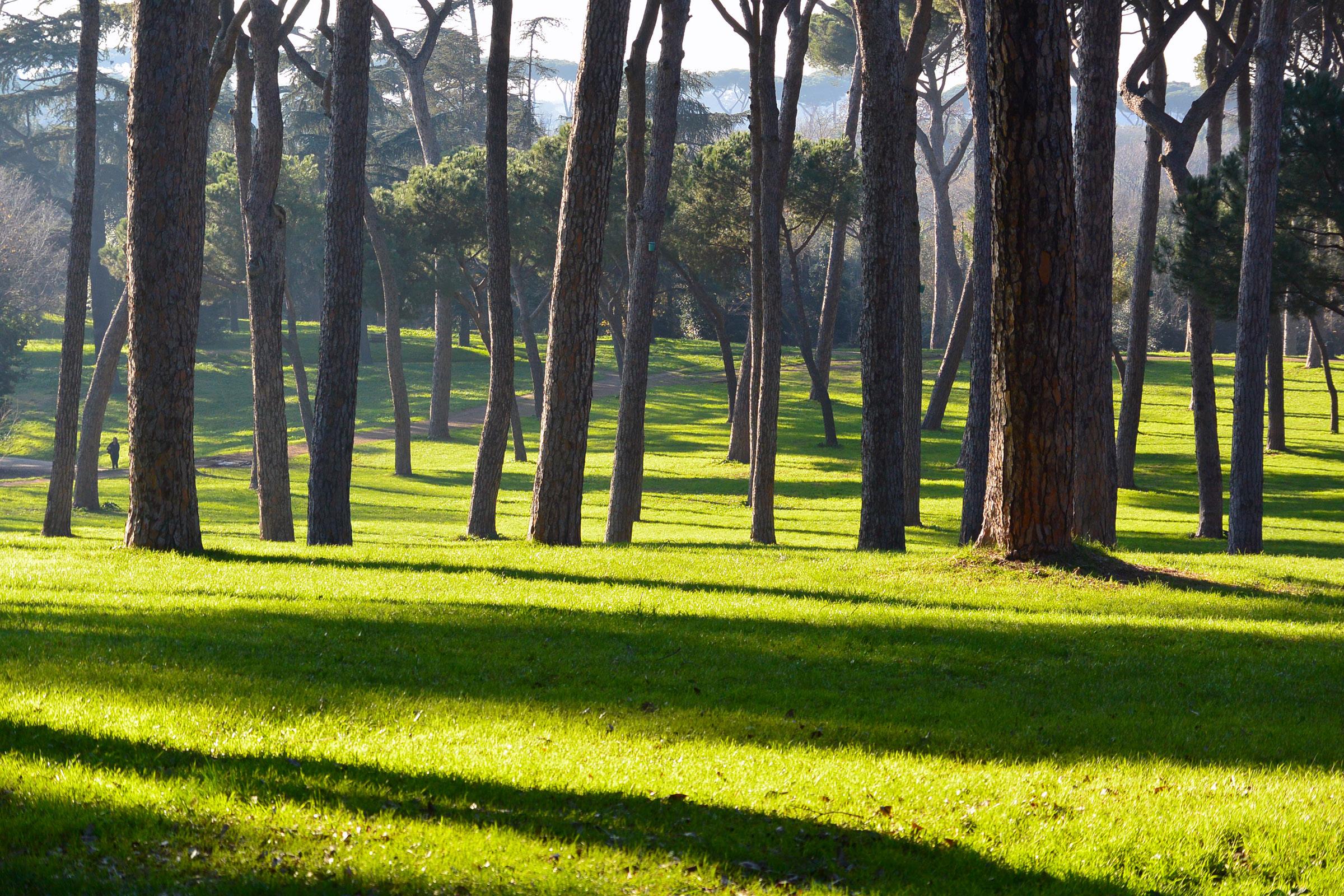
Villa Doria Pamphili, Rome, 2014, Image courtesy of Fritz Steiner
PART 1: Environmental Theorists
Rocky Mountain National Park, Colorado (photo by Elizabeth VanDerwerken)
Daniel Hudson Burnham - Architect and Urban Planner
Sylvanus Narh Duamor
Make no little plans. They have no magic to stir men’s blood and probably themselves will not be realized. Make big plans; aim high in hope and work, remembering that a noble, logical diagram once rewarded will never die, but long after we are gone will be a living thing, asserting itself with ever-growing insistency. Remember that our sons and grandsons are going to do things that would stagger us. Let your watchword be order and your beacon beauty.
- Daniel Burnham, The Plan of Chicago (1909)
Introduction
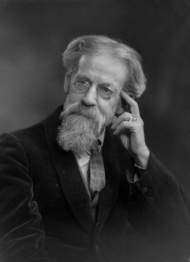
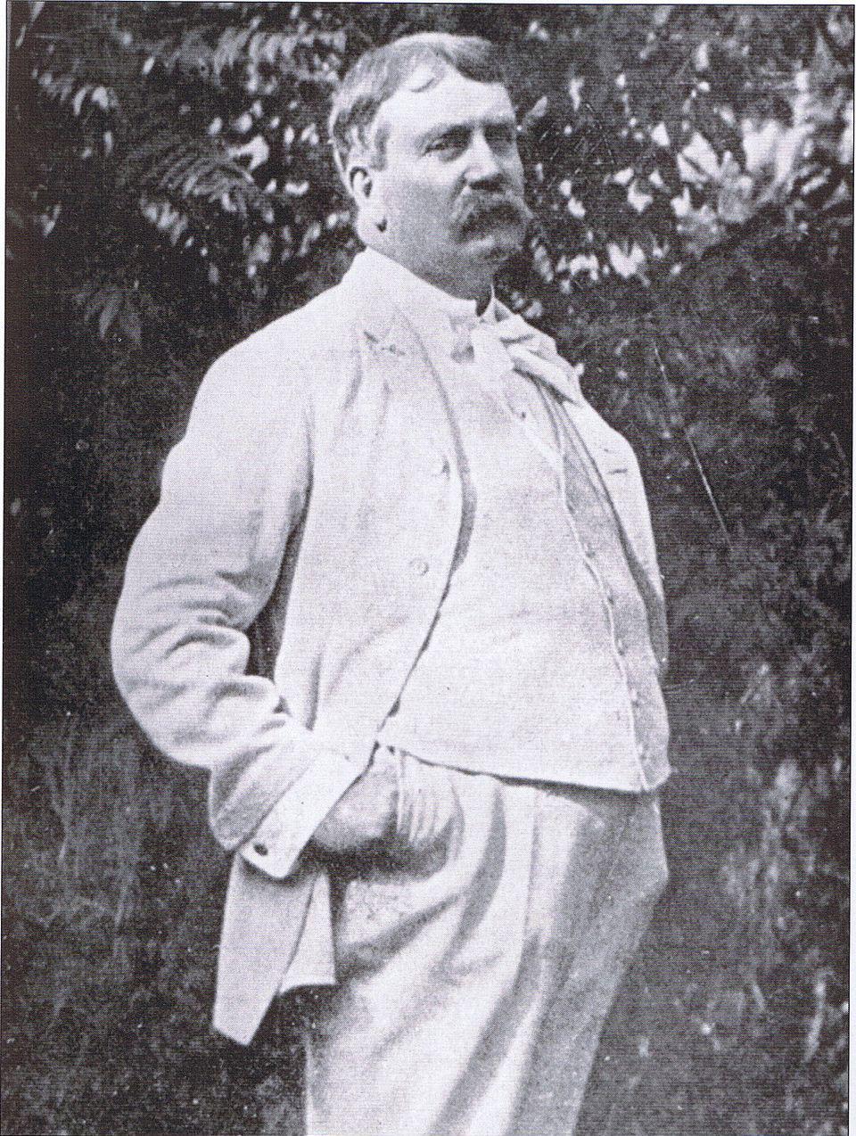
Daniel Hudson Burnham (see Fig. 1) was an American architect and urban planner whose influence extended well beyond the shores of the United States of America although he spent most of his life in Chicago. His credo – “Make no little plans. They have no magic to stir men’s blood…” – was not merely inspirational, but more so an affirmation of his big plans and achievements. Burnham played a key role in many phenomenal projects including the World’s Columbia Exposition, the Plan of Chicago, and the City Beautiful Movement. Also, he and John Wellborn Root were known for being instrumental in the designing and building the first skyscrapers in the United States. He remains a prominent figure in the history of architecture and planning
His Life and Work
Origin, Early Years, and Finding His Feet
Burham was born on September 4, 1846, in Henderson, New York. He was the sixth of seven children and the youngest son. His mother, Elizabeth Keith (Weeks), was a cook, housekeeper, and somewhat of a farmer, and his father, Edwin Arnold Burnham, was more of a businessman. His character was the issue of his life-long consciousness of two ancestral influences: his AngloAmerican antecedents and his family’s Swedenborgian religion (which was outside the mainstream of orthodox Christianity.1 Being an eight-generation American, Burnham had a deep regard for the involvements of the AngloAmerican ethnicity in the country’s background, as well as his own roots. His
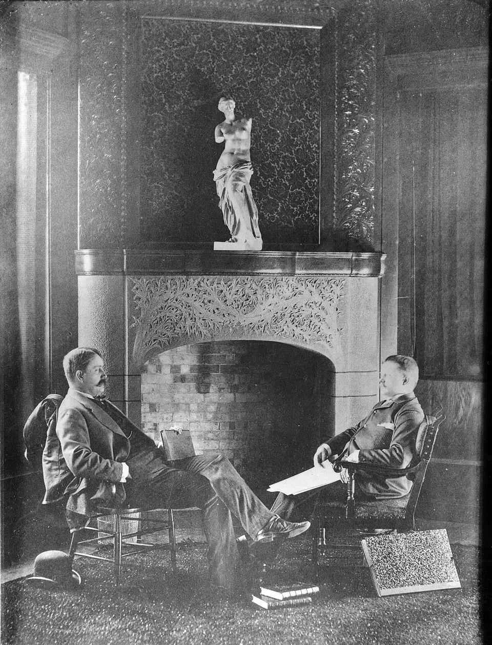
Source: Via book Graf, John, Chicago’s Parks Arcadia Publishing, 2000, p. 62., ISBN 0-7385-0716-4.
Figure 1 Daniel Burnham on the terrace of his Evanston, IL home
world during the first half of his life, which consisted of his family, his friends, and his early associates in New York, Chicago, Nevada, and Boston, was all Anglo-American, descendants of Englishmen. His ancestry, beginning from Thomas Burnham down to his father, included very successful lawyers, mill owners, farmers, and ministers, and many sat in the Massachusetts General Court.2, 3
Burnham’s mother was the grand-daughter of the theologian, Samuel Hopkins, whose cousin was Mark Hopkins, a well-known nineteenth-century president of Williams College and colleague of revivalist preacher Jonathan Edwards. Her father, Holland Weeks, was an ordained Congregationalist in the New Jerusalem Church, which was also called the Swedenborgians, named after Emanuel Swedenborg. Weeks moved to Henderson, New York, after being excommunicated for condoning, among other things, the theological doctrines of Swedenborg, and established his own congregation, called the New Church. Edwin Burnham joined the church and married Week’s daughter, thereby deepening his commitment to his father-in-law’s religion. Both his paternal and maternal lineage instilled in Daniel Hudson Burnham the work-oriented subculture of Anglo-American Puritanism, while his maternal grandfather would come to inculcate the moral code of Swedenborgian Christianity.4
Burnham’s father was known to be a loving and attentive father, however, his influence on the upbringing of the children was not as significant as that of their mother. Her friendly and fun-loving character made her very approachable to all. She was considered a sympathetic listener and a reliable friend with a remarkable openness of mind. She urged her children to take care of their health, which Burnham received and diligently practiced throughout his life. He also learned how to play the piano from her. Burham’s mother had a strong influence on him, such that his sister, Clara, indicated that his traits of “courage, progressiveness, clear judgment, ready sympathy, sincerity, …truthfulness, (and) moral responsibility” were “characteristics inherited…from his mother.” Burnham began his formal education in Henderson. His mother convinced his father to move to Chicago after her father’s death, where Burnham continued his schooling at Snow’s Swedenborgian Academy. He then attended the Jones and Dearborn public school in his early teens and Chicago’s Central High School, where he excelled in artistic projects and athletics at the expense of his academics. In 1863, Burnham was sent to a preparatory school in Waltham, Massachusetts, in hopes of him gaining admission to Harvard University. But even after intensive studies under a private tutor, Reverend Tilly Brown Hayward, he failed the entrance exam, attributing his failure to “stage fright,” in light of his parents’ expectations and his own academic fears. He was also unsuccessful at gaining admission to Yale University.5, 6
In 1867, he returned to Chicago with a discouraged and restless disposition. He took on a salesman position in a mercantile house but did not find the work satisfying and quit after four months. In an attempt to put himself together, he recalled his conversations with his tutor, Hayward, about the history and practice of architecture, and his discussions with Hayward’s family friend, W. P. P. Longfellow, who later became professor of architecture at M.I.T. He gave architecture a try and became a draftsman apprentice for William Le Baron Jenney, the great architectural pioneer. In 1868, he wrote to his mother indicating that he would try to become “the greatest architect in the city and country.” He added, “there needs but one thing. A determined and persistent
effort.” However, in 1869, young, ambitious, and restless, he quit his job with Jenney in order to seek his fortune in Nevada with his friend, Edward C. Waller. There, he tried mining and ran for the state senate. Unsuccessful in both attempts, he returned to Chicago in 1870. After deep thought about himself and his development, he revived his passion for architecture and decided to return to it.
In 1872, Burnham secured a job with Carter, Drake and Wight, a firm that was actively involved with the rebuilding of Chicago after the fire disaster. Peter Wight became Burnham’s sympathetic mentor and provided the scholarly training that Burnham lacked. He began to build on his strong points, which increased his confidence and allayed his self-doubts. Burnham met John Wellborn Root, who would soon become his future partner, in Wight’s office.
Burnham and Root
The partnership between Burnham and Root (see Fig. 2) proved exceedingly successful and at an unexpected speed. Over 18 years of working together, they built more than 500 buildings worth over $40 million, including hospitals, stores, warehouses, schools, hotels, railroad stations, office buildings, residences, and miscellaneous structures such as ceremonial monuments, casinos, convents, and barns. They earned a compelling reputation among their contemporaries for their finest works that later generations would more than appreciate. Both married and started families during those years and attained a high professional and social prominence in Chicago and beyond. By the time Root died in 1891, they had become well-established and well-known architects and respected citizens.7, 8
Root’s story was very different from Burnham’s, which made the two men a robust duo. Root was born in 1850 into a rich family in Lumpkin, Georgia. During the period of the Civil War, his parents sent him away to a school in Liverpool, where he studied music with William Best, England’s greatest organist. Unlike Burnham, Root excelled in academics, passed the entrance exam, and gained admission to Oxford University. However, his parents had him return home before he matriculated in 1866 following the end of the Civil War. He went to New York University where he studied engineering and graduated with honors in 1869. He loved music and architecture but decided to become an architect after graduating. He worked with James Renwick, the builder of St. Patrick’s Cathedral, for a little over a year and then with J. B. Snook for the same amount of time, before moving to Chicago in 1872. In Chicago, he secured a job at Carter, Drake, and Wight where he made head draftsman due to his impressive credentials and practical experience. There, the two men met and became best friends. Burnham was able to persuade Root to become his partner, and in the following year, they left Peter Wight and started their own business. Root primarily made the detailed designs while Burnham planned the layout of the interiors of their buildings and organized the business. Harriet Monroe, a poet and editor, who was the sister of Root’s second wife and a friend to both Root and Burham, believed that Burnham was the zealous influence Root needed. During his 1912 address at the American Institute of Architects in Illinois, Wight also noted that:
Burnham had a great faculty of impressing his clients with the firm’s ability to solve any problem that came to it. He would make rapid sketches, which Root afterward elaborated with the
Source: Chicago Historical Society (ICHi-37303)
greatest care. He inspired confidence in all who came within the range of his positive and powerful personality. Root had the ability to carry to success anything that Burnham offered to do.
Thus, with their contrasting and reciprocal qualities and temperaments, the two men formed a dynamic team that led their profession during their time and influenced the history of architecture in the US.
Their first big commission, the firm’s turning point, came a year after their partnership began – a contract to design a house for John B. Sherman, the Union Stockyards magnate. Burnham and Root’s connection with Sherman was made by George Chambers, who was one of Sherman’s protégés and a friend of Root. Sherman sought to build a new house and Chambers recommended the partners. A meeting was scheduled to introduce the partners but only Burnham could make it since Root was out of the city. Sherman instinctively
Burnham and Root
liked Burnham and was pleased with the building proposal. During this time, Burnham and Margaret, Sherman’s daughter, caught one another’s attention and they got married in 1876 before the building was completed. The structure caught the perceptive eye of Louis Sullivan, their contemporary and rival, who recalled its proportions and fine lines in his autobiography. Sullivan also admired Burnham’s largeness of vision, the imagination of a dreamer, and his settled will to go through hell to reach an end.
First Skyscrapers
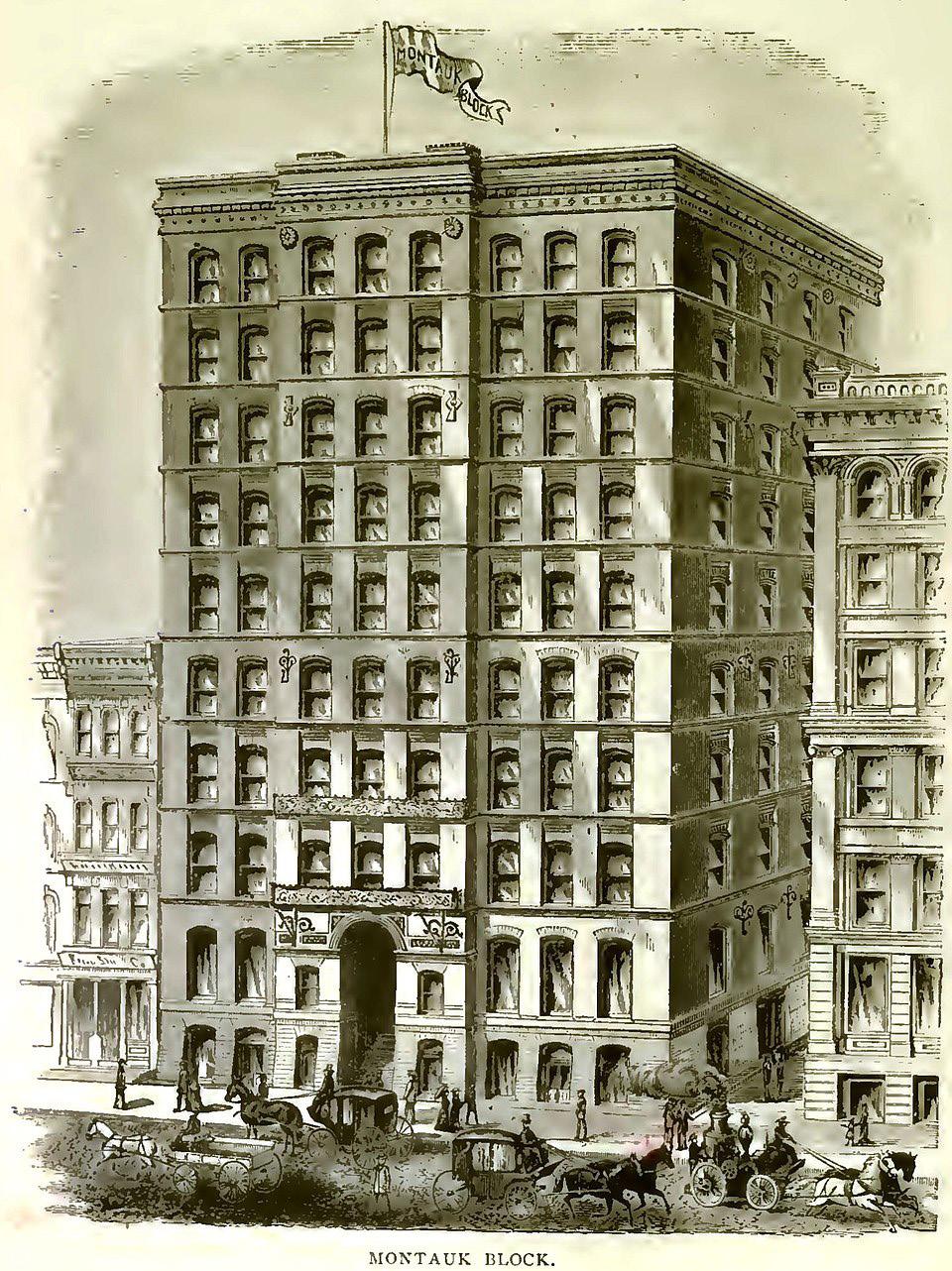
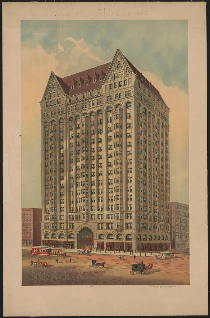
The firm’s next commission was the design and construction of the Grannis Block, a structure that was seven stories high, where they had their office until it was destroyed by fire. This period formed the beginning of the construction of tall buildings and Burnham & Root was at the forefront. The famous Montauk Building (see Fig. 3), completed in 1883, was the firm’s next monumental project. The ten-story fire-proof building became the tallest building in Chicago at its completion and was the first building labelled a “skyscraper.” 9 Chicago’s watersaturated sandy soil and bedrock 125 feet (38 m) below the surface paved the way for the demonstration of Root’s ingenuity. He devised a new kind of foundation footing – a “floating foundation” that was, in effect, an artificially created bedrock upon which the heavy building could be constructed. The firm moved into their new masterpiece, where partners designed the Rockery Building, the Pheonix Insurance Building, the old Insurance Exchange, and the north half of the Monadnock Building (being sixteen stories above ground, it reached the tallest practical height using traditional construction techniques). The Montauk Building was demolished in 1902 while Burnham was still alive. When the Rockery Building was completed, the firm moved into it and remained there until Burnham built the Railway Exchange in 1903. The Railway Exchange still exists, housing several architecture firms. The final and most beautiful of all the great buildings designed by the firm was the Masonic Temple (see Fig. 4) completed in 1890. At a staggering 21 stories high, the Masonic Temple with its great atrium was a marvel. It was heralded as the tallest office building in the world in terms of occupied floors. It was demolished in 1939.
Burnham and Root made a formidable pair, and the success of their firm was known far and wide. They completed numerous projects in major U.S. cities including Chicago, New York, Philadelphia, Washington, D.C., San Francisco, Indianapolis, Cincinnati, Detroit, Pittsburgh, and others. Burnham & Root set a longstanding standard for future architectural firms at a time when the profession was still emerging.
The World’s Columbian Exposition of 1893
The World’s Columbian Exposition of 1893 was the largest world fair to that date. It celebrated the 400-year anniversary of Christopher Columbus’s famous voyage to America. As the director of works of this remarkable project, Burnham established his extraordinary leadership skills. Burnham was invited to consult with the Committee established to appear before Congress regarding the potential siting of the fair in Chicago. Frederick Law Olmsted and his partner, Harry Codman, were also invited to consult with Burnham. By August of 1890, Olmsted had proposed Jackson Park on the south lakefront. Burnham and Root were made consulting architects, Olmsted and Codman were consulting landscape architects, and Abraham Gottlieb was the consulting engineer. In October, Burnham & Root resigned from the
Montauk Building
Source: A. T. Andreas ‘History of Chicago.’ 1886.
Committee, and Root was made Consulting Architect and Burnham Chief of Construction.
To ensure proper progress in the design and construction of the Columbian Exposition, Burnham wrote to the Committee to suggest the recruiting of five architects or firms, namely, Richard M. Hunt; McKim, Mead, & White; George B. Post; Peabody & Stearns; and Van Brunt & Howe, which the Committee authorized. The Committee also authorized Burnham to select five Chicago architects to design five other great buildings for the Exposition. Burnham selected Burling & Whitehouse, Jenney & Mundie, Henry Ives Cobb, S. S. Beman, and Adler & Sullivan. At a dinner organized by the Committee for the architects, Burnham gave a remarkable speech that inspired a spirit of cooperation within everyone. A few days later, John Root contracted pneumonia and died. Burnham lost his partner and best friend, but continued to work on the
Exposition as everyone encouraged him. After long discussions regarding the way forward, the plan prepared by Root was adjusted with important changes and Burnham apportioned the work to all the architects. By late February 1891, the whole work was adopted by everyone, and construction began. Burnham supervised the construction of 150 buildings on more than 600 acres of land and led a workforce that reached 10,000 men.10, 11
At the end of the project, Burnham, together with America’s most prominent architects and designers, produced America’s most magnificent world’s fair
Masonic Temple
Source: Library of Congress
Online Catalog
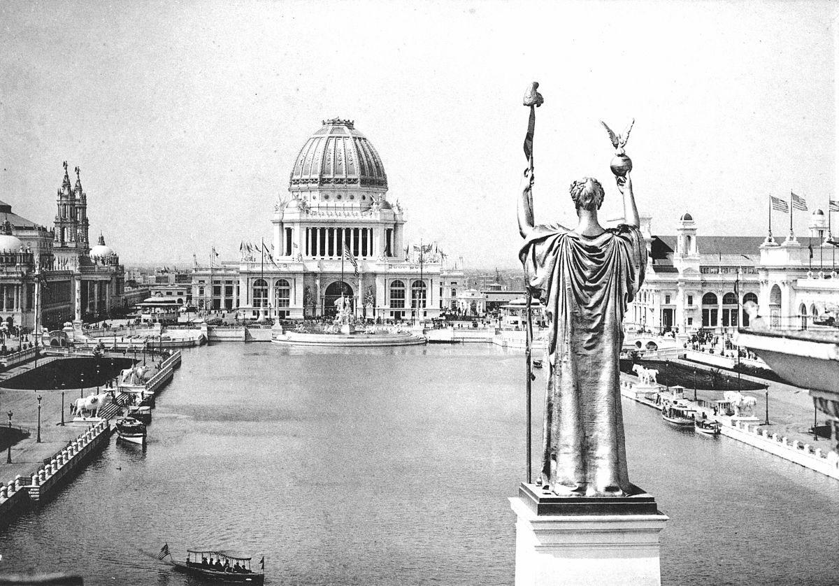
Looking West From Peristyle, Court of Honor and Grand Basin of the 1893 World’s Columbian Exposition (Chicago, Illinois)
Source: The Project Gutenberg EBook of Official Views Of The World’s Columbian Exposition
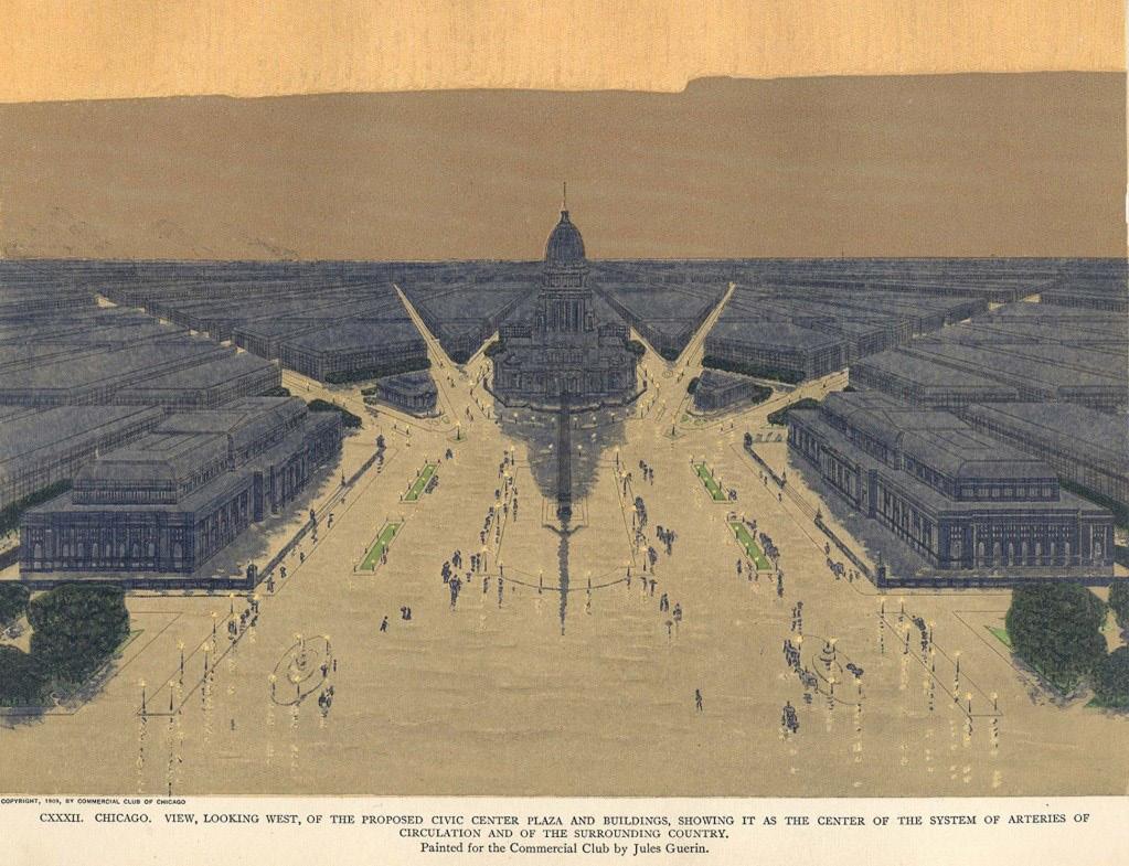
of the 19th century. Nicknamed the “White City,” it popularized neoclassical architecture in a monumental, yet rational Beaux-Arts style, planned as a cohesive whole in a landscape setting (see Fig. 5). It made a long-lasting impression on millions of visitors. It is often regarded as the inspiration for the City Beautiful movement and a turning point both for Burnham and for the design of the modern American city. The success and beauty of the fair considerably enhanced Burnham’s reputation, which led Harvard and Yale to award him honorary master’s degrees. In July 1893, Burnham was elected as the president of the American Institute of Architects, in recognition of his organizing and administrative abilities.
1909 Plan of Chicago and the City Beautiful Movement
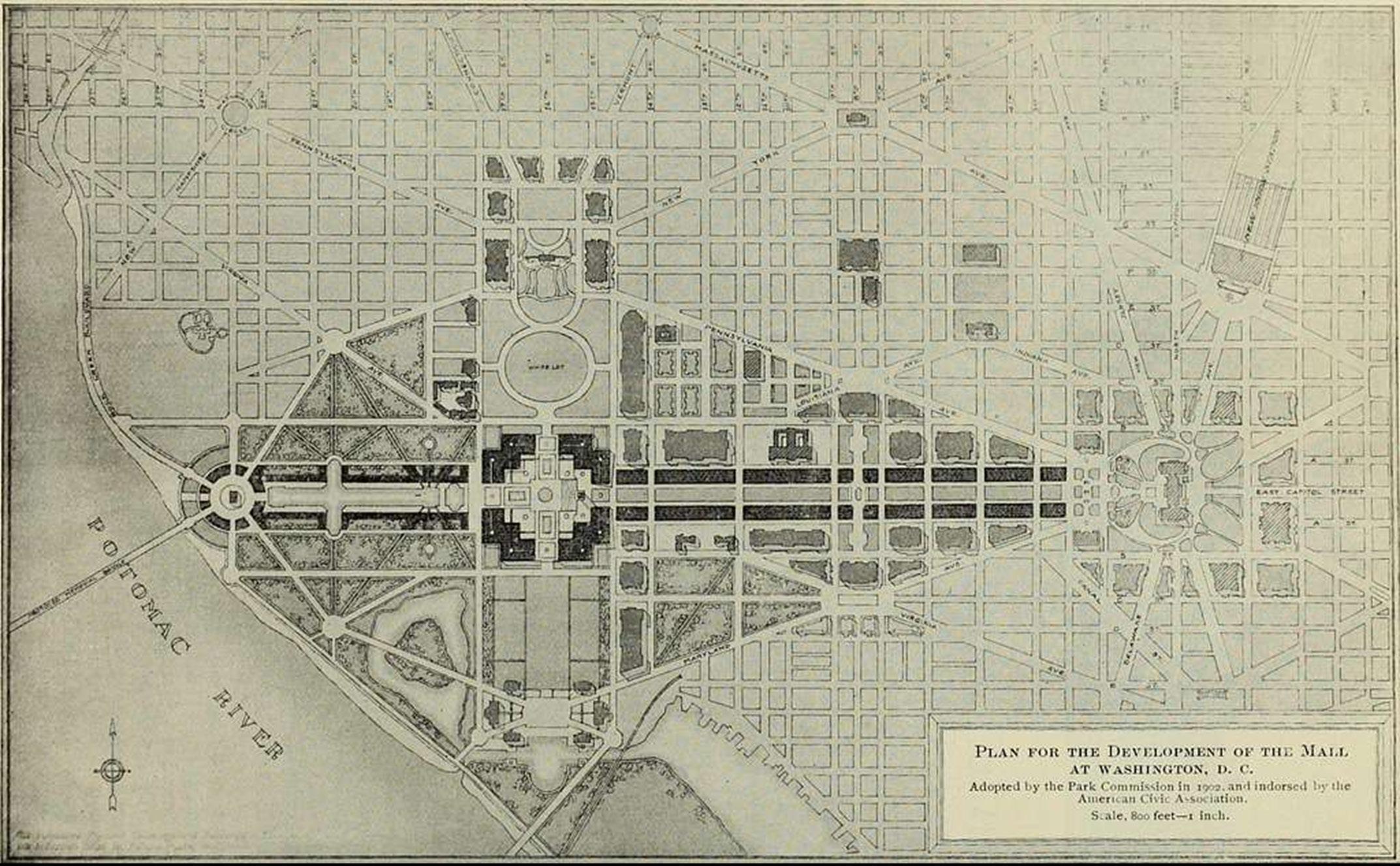
Burnham’s work on the world’s fair had developed in him a keen interest in parks and city planning. He believed that “an improved urban environment could provide a positive transformative experience for its inhabitants.”12 In 1909, Burnham and his co-author Edward H. Bennett published the Plan of Chicago. The project was initiated in 1906 by the Commercial Club of Chicago and the Merchants Club. Prior to the Plan of Chicago, Burnham had presented ideas for improving Chicago’s lakefront, and had worked on plans for other cities including Washington, D.C., Cleveland, and San Francisco, as well as Manila and Baguio in the Philippines, the majority of which barely came to fruition. In Washington, D.C., Burnham contributed much to the 1901 McMillan Plan, which facilitated the completion of the overall design of the National Mall. Burnham and three of his colleagues from the World’s Columbian Exposition, including Frederick Law Olmsted, Jr., Charles Follen McKim, and Augustus Saint-Gaudens, were brought together by the Senate Park Commission, established by Michigan Senator James McMillan. Burnham was appointed head of a commission in 1902. The commission “recommended a new civic center in which half a dozen major civic buildings would be grouped in a set of linked public parks, alongside the lakefront and on a broad mall at right angles to it, which together would form an impressive open space in front of the city’s
relocated main railway station: a clear echo of the Washington plan, which had also included a re-sited Union Station.”13
In 1906, Burnham’s plan for San Francisco was something far grander. Here, “a new civic center complex – strategically located at the junction of Market Street, the city’s main commercial street, and Van Ness Avenue – was to be the focus of a set of radiating boulevards, from which in turn subsidiary radials would take off at intervals; thus the city’s regular grid would be brought into “miraculous formal equilibrium” by another logic of angular abutments and natural irregularities used as sites for boulevards and formal buildings. One of these would form a continuous park strip leading to the Golden Gate Park on the west side of the city. There would be a formal architectural treatment on the Twin Peaks which dominate the city’s southwest side, with an Athenaeum and a monumental statue facing out over the Pacific Ocean.”14 Though the extraordinary accident of the earthquake and fire provided the opportunity for the city to implement the plan, only fragments were developed due to commercial pressures.
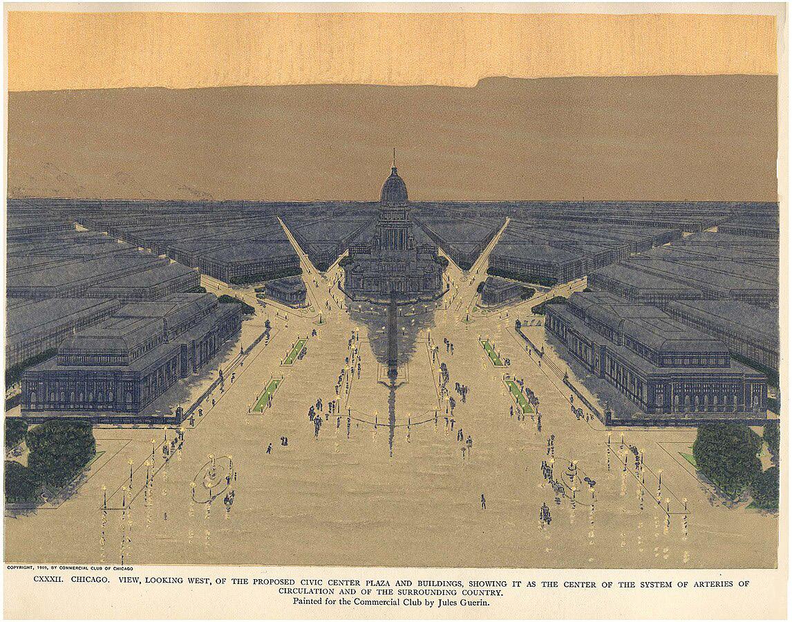
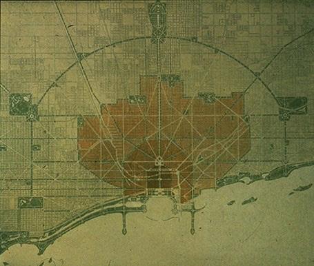
Burnham’s plan for Chicago was the most successful of all his plans, although the central piece (see Fig. 6) was the part that was not completed. It was “to restore to the city a lost visual and aesthetic harmony, thereby creating the physical prerequisite for the emergence of a harmonious social order; the chaotic city, that had arisen through too-rapid growth and too-rich a mixture of nationalities, would be given order by cutting new thoroughfares, removing slums, and extending parks.”15 The plan received the backing of the upper and middle classes due to its social and aesthetic objectives. It was the first comprehensive plan aimed at controlling the growth of an American city and the propagation of the City Beautiful movement. The plan set the standard
(Courtesy of Chicago Architecture Center)
Figure 5: Plan of Chicago: Proposed Civic Center by Commercial Club of Chicago
for urban design, anticipating the future need to control urban growth. It continues to shape the development of Chicago and several cities until now.
Conclusion
Burnham’s personality was strongly influenced by his Anglo-American lineage and his family’s Swedenborgian religion. Although he was more artistic and athletic than academic in his early years, after struggling for some time regarding what to do, he finally began to make substantial progress under Wight’s mentorship. With grand ambitions he persuaded and partnered with his new but immediately close friend, Root, an extraordinarily talented architect who complemented him perfectly. Together the two men built one of the largest and most successful architectural firms in the country. They achieved some groundbreaking feats in the architectural industry, including designing and constructing the first, as well as the tallest, skyscraper during their time. Burnham’s most notable legacies include the World’s Columbian Exposition in 1893 of which he was the chief of construction, the 1909 Plan of Chicago and the City Beautiful Movement which significantly influenced urban design and planning. Burnham remains an important character in architecture, landscape architecture, and urban planning, and his influence continues.
Notes
1. Hines, Thomas S. 2009. Burnham of Chicago: Architect and Planner. 2nd ed., pbk. Ed. Chicago: University of Chicago Press.
2. Hines, 2009
3. Moore, Charles. 1921. Daniel H. Burnham, Architect, Planner of Cities. Boston, New York: Houghton Mifflin Company. https://catalog.hathitrust.org/Record/000451402
4. Hines, 2009
5. Ibid.
6. Moore, 1921
7. Ibid
8. Hines, 2009
9. Larson, Erik. 2003. The Devil in the White City: Murder, Magic, and Madness at the Fair That Changed America. 1st ed. New York: Crown Publishers.
10. McBrien, J. Paine. 2023. “Daniel Burnham.” Encyclopedia Britannica. Daniel Burnham (blog). August 31, 2023. https://www.britannica.com/biography/Daniel-Burnham
11. Hines, 2009
12. McBrien, 2023. p. 3
13. Hall, Peter. 2014. Cities of Tomorrow: An Intellectual History of Urban Planning and Design since 1880. Fourth edition. Chichester: Wiley-Blackwell. p. 206
14. Hall, 2014. p. 207
15. Ibid.
Patrick Geddes: Visionary Urban Planner and His Enduring Legacy
Hui Tian
Introduction
Patrick Geddes (1854–1932) is an influential yet controversial figure in the history of urban planning (Figure 1). With a background in biology, sociology, geography, and civic design, Geddes pioneered a holistic approach to urban planning that emphasized the interconnectedness of people, place, and environment. His theories, such as the Valley Section, Regional Survey, and Conservative Surgery, laid the groundwork for modern ecological urbanism and regional planning. However, Geddes’ interdisciplinary and often unconventional methods have been met with both admiration and criticism. This study argues that Geddes’ legacy lies in his ability to bridge the gap between scientific rigor and practical application, offering a framework for sustainable urban development that remains relevant today.
Biography: Early Life, Education, and Influences
Early Life and Intellectual Formation
Patrick Geddes was born in Ballater, Scotland, into a strict Calvinist household. His father, a disciplined soldier, instilled in him a belief in applying skills to human-environment challenges, fostering a moral and spiritual perspective that shaped Geddes’ lifelong desire to serve humanity.1 From an early age, Geddes developed an ecological outlook, viewing cities and regions as interconnected systems, influenced by his childhood experiences in Perthshire.2
In the 1870s, Geddes studied biology under Thomas Huxley in London, but he diverged from Huxley’s mechanistic view of nature, emphasizing cooperation over competition. This perspective later informed his holistic approach to social and urban systems. He was also influenced by Frédéric Le Play’s studies on the interplay between environment, economy, and society.3 A turning point came in 1879 during a botanical expedition to Mexico City, where an illness left him temporarily blind. This experience led him to envision the integration of diverse disciplines, shaping his interdisciplinary approach to urban studies (Boardman, 1978; Kitchen, 1975).4, 5 Health issues in the 1880s shifted his focus from microscopic biology to human societies, marking a transition to larger-scale systems.6
Despite lacking a formal degree, Geddes became a botany lecturer at the University of Edinburgh in 1880. In 1889, Geddes was endowed with the Chair of Botany at the University of Dundee, which allowed him to travel and pursue
Source: http://www.npg.org. uk
diverse interests. His interdisciplinary approach often clashed with academic norms, limiting his opportunities at leading universities.7, 8
Travels and Intellectual Cross-Pollination
Geddes’ travels profoundly influenced his work. Between 1914 and 1924, he served as a town planning consultant in India, where he advised on urban planning for around fifty cities. Despite personal losses, including the deaths of his wife and son, this period produced some of his most impactful work.9
In 1918, Geddes contributed to planning the Hebrew University in Jerusalem and the city’s development, integrating modern planning principles into a renewed homeland. He also exhibited his Cities Exhibition in India, Paris, and
Figure 1. Sir Patrick Geddes, by Lafayette (Lafayette Ltd) half-plate nitrate negative, 30 December 1931 Given by Pinewood Studios via Victoria and Albert Museum, 1989
Jerusalem, and lectured across Europe, Palestine, and the United States, further spreading his ideas.10 Geddes’ work in diverse cultural contexts reinforced his commitment to context-sensitive design and interdisciplinary approaches, solidifying his legacy as a pioneer in urban planning and regional studies.
Development of Theories on Urban Planning
Patrick Geddes’ theories on urban planning evolved over time, shaped by his interdisciplinary education, extensive travel, and engagement with diverse intellectual traditions. This section examines the chronological development of his key theories, highlighting their influences and contexts.
Thinking Machines (1879)
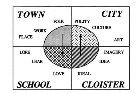
In the context of the Industrial Revolution and the rise of modernity, Geddes was influenced by Frédéric Le Play’s work on social organization, particularly the triad of “Lieu, Travail, Famille” (Place, Work, and Family). Geddes adapted this framework into his own triad of “Place, Work, and Folk,” which he saw as the foundational dimensions of society, reflected in geography, economics, and sociology.11 The term “thinking machines” is likely metaphorical, referring to the interconnected systems of thought, organization, and social structures that shape human societies (Figure 2). Geddes viewed these systems as dynamic and interdependent, functioning like complex machines that could evolve through thoughtful planning and awareness. He used synthetic graphic “thinking machines” to illustrate these interactions, emphasizing the need for holistic and integrated approaches to urban planning.12 However, as Geddes refined this theory, he increasingly distanced himself from his audience, culminating in indifference when he presented his completed theory—town, school, cloister, and city proper—at a Sociological Society meeting in 1914.13
Source: Meller, 1990
Figure 2. The city completed
Source:
The Valley Section (1890s)
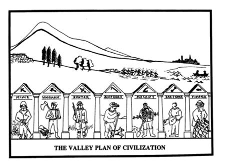
Inspired by the work of Elisée Reclus, particularly his book Géographie Universelle: la Terre et les Hommes, Geddes developed the concept of the valley section to illustrate the relationship between human settlements and their natural environments (Figure 3). The valley section depicted a crosssection of a river valley, from its source in the hills to its estuary on the plains, showing how different human activities, such as mining, farming, and urban development, are distributed across the landscape.14 Geddes used the valley section as both a practical tool and a metaphor for understanding the complex interplay between human adaptations and environmental conditions. By situating activities like fishing and mining within the context of regional ecosystems, he highlighted the importance of aligning human development with natural systems.15
Regional Survey (1904)
Geddes’ regional survey was rooted in his belief that cities and towns could not be understood in isolation from their surrounding regions. He argued that effective urban planning must be based on a comprehensive understanding of the region’s natural, social, and economic dynamics.16 The regional survey represented a holistic, ecological study that gathered extensive data on climate, geology, history, architecture, and socio-economic factors.17 By examining a region comprehensively, Geddes aimed to highlight the interdependence of nature and culture, a perspective that remains relevant in contemporary urban planning.
Geddes’ methodology for regional surveys involved systematic data collection and analysis, forming an empirical foundation for planning decisions. He emphasized the principle of “survey before planning,” which focused not only on the physical attributes of a space but also on the rhythms of local life, including the actions, behaviors, and collective memory of its inhabitants.18 This participatory and interdisciplinary approach significantly influenced the
Figure 3. The Valley Section and Basic Occupations
Meller, 1990
town planning movement, promoting ecological sustainability and community engagement.
Conservative Surgery (1904)
After survey or diagnosis, Geddes advocated conservative surgery with an approach considering “the existing physical, social, and symbolic landscape of a place in order to allow its most favorable future development.”19, 20 In his first planning commission for improving the park system in Dunfermline, Geddes began with a thorough survey of the needs, resources, and aspirations of the population as the basis for guiding future growth. In addition, Geddis illustrated how only minor changes could enhance a situation by juxtaposing a photograph of existing conditions with a photo edited towards a prospective change. Confronting “slum clearance” in the Indian demolition scheme, Geddes emphasized the conservative surgery approach where “small local improvement should precede large central ones” in his suggestion to the Maharaja of Balrampur.21
Cities in Evolution (1915)
In Cities in Evolution (1915), Geddes integrates and expands upon his earlier theories, presenting a holistic framework for understanding the complex interplay of environment, society, and history in urban development. In his early book City Development: A Study of Parks, Gardens, and Culture-Institutes (1904), Geddes described cities as dynamic, evolving organisms that grow in response to their environment, society, and economy. He saw town planning as a process rooted in the Valley Section’s occupations, evolving through towns, schools, and cities, guided by the Thinking Machine. Surveys, exhibitions, and museums were tools to mobilize citizenship and drive development.22
Geddes’ earlier work on “Civics” and the “Science of Cities” laid the foundation for his holistic approach to urban planning, and this perspective is central to Cities in Evolution. He emphasized the holistic view of cities as synthetic wholes, where the physical environment, social structures, and moral well-being are deeply interconnected, which echoes his theory of the Thinking Machine. He introduced Civic Hygiene, addressing not just physical cleanliness but social issues like crime and poverty, linking urban improvement to better citizenship. He advocates for direct evolution, where planners consciously guide urban development, aligning it with historical ideals and contemporary needs. Section and Regional Survey offer practical tools for analyzing and guiding development at local and regional scales, emphasizing the interdependence of rural and urban areas. Conservative Surgery ensures respectful, effective interventions, while civic responsibility calls for planners to address social and moral well-being, engaging citizens in urban improvement. By balancing regional interdependence, historical continuity, and sustainable development, Geddes offers a framework that respects the past while guiding cities toward a sustainable and harmonious future.23
Geddes’ Key Projects
Laboratory of Civic Renewal in Edinburgh
Patrick Geddes’ work in Edinburgh’s Old Town vividly demonstrated his innovative urban planning principles. Living in Edinburgh’s impoverished Royal Mile, he developed a commitment to slum rehabilitation and city planning.
Faced with deteriorating slum conditions, he rehabilitated tenements and established Scotland’s first student hostel, pioneering his principle of conservative surgery—prioritizing housing rehabilitation over purely aesthetic or transportation concerns.24
Central to Geddes’ efforts was the Outlook Tower, which he transformed into a “museum of cities” in the 1890s. This five-story building, topped with an observation gallery, served as a “sociological laboratory” and a hub for civic education (Figure 4). Geddes used historical maps, photographs, and charts to illustrate Edinburgh’s development, its impact on residents, and its global economic and cultural significance. In 1910, Geddes organized a pictorial survey of Edinburgh for the Town Planning Exhibition at the Royal Academy, coinciding with the passage of the Town and Country Planning Act. He later expanded the exhibit to include other cities, showcasing it across the British Isles and at the 1913 Ghent International Exposition. These exhibits cemented Geddes’ reputation as a pioneer in urban planning and civic engagement.
Urban Planning in Colonial India
Geddes arrived in India at the age of 60, invited by the British Governor of Madras to share his expertise in urban planning. Over the next ten years, he consulted on town planning for over 50 Indian cities, advocating for a method rooted in intimate knowledge of local conditions. He believed planners, like naturalists, should closely observe the interaction between people and their environment, emphasizing respect for place and community.25
Rejecting the widespread “slum clearance” approach, Geddes championed “conservative surgery”—a strategy of small, incremental improvements over large-scale demolition. In Lucknow, for example, he proposed widening streets only where necessary, creating open spaces, and establishing housing loan banks to assist displaced residents. In Bombay, his 1915 plan emphasized upgrading existing neighborhoods rather than demolition, introducing shaded courtyards and improved sanitation. His approach prioritized preserving existing neighborhoods and avoiding the displacement caused by sweeping urban redevelopment.26, 27
Geddes’ influence extended beyond India. In Palestine, his garden city vision for Tel Aviv and his early plan for the Hebrew University in Jerusalem left a lasting mark on urban development (Hysler-Rubin, 2011). While many of his plans were partially implemented, his emphasis on preserving historic neighborhoods through “conservative surgery” helped save cultural and architectural heritage in cities like Indore and Tel Aviv.28
Criticisms and Limitations
While Patrick Geddes is celebrated for his visionary urban theories, his contributions were often overlooked during his lifetime —due in part to his unconventional methods, elusive working style, and distinctive personal traits. Trained as a biologist, Geddes applied concepts of evolutionary to urban and social systems, promoting an expansive interdisciplinary vision that resisted categorization within traditional academic fields.29 Rather than establishing a formal theoretical framework, Geddes continuously generated new ideas, preferring lectures and exhibitions over scholarly treatises. His reluctance
to defend or refine previous arguments made his work appear fragmented. Aside from Cities in Evolution (1915), most of his publications co-authored with other people, resulting in various quality. Much of his other intellectual legacy survives in letters, reports, and ephemeral materials that lie outside traditional academic channels.30 His dense prose, frequent repetition of key concepts, and abstract diagrams often rendered his ideas inaccessible to wider audiences.
Personally, Geddes was intensely committed to his work, often at the expense of family life. Though supported by his wife, children, and students, many found themselves adapting to his demanding and autocratic temperament. To outsiders, he was often seen as a dreamer or eccentric. In his final major work, Life: Outlines of General Biology, he reaffirmed his mission to apply natural science to society renovation, though it found little contemporary readership.31
Facing the social upheavals of industrialization, Geddes believed that Darwinian evolution called for a new way of thinking—one centered not on material production but on human development. He rejected both capitalism and socialism as sufficient solutions, envisioning a cultural evolution that restored balance between the natural and built environments.32 Although his ideas gained limited traction during his life, they later inspired followers like Jaqueline Tyrwhitt, Lewis Mumford and more people, who helped translate his humanistic planning vision into enduring theories and practices.
Legacy and Contemporary Relevance
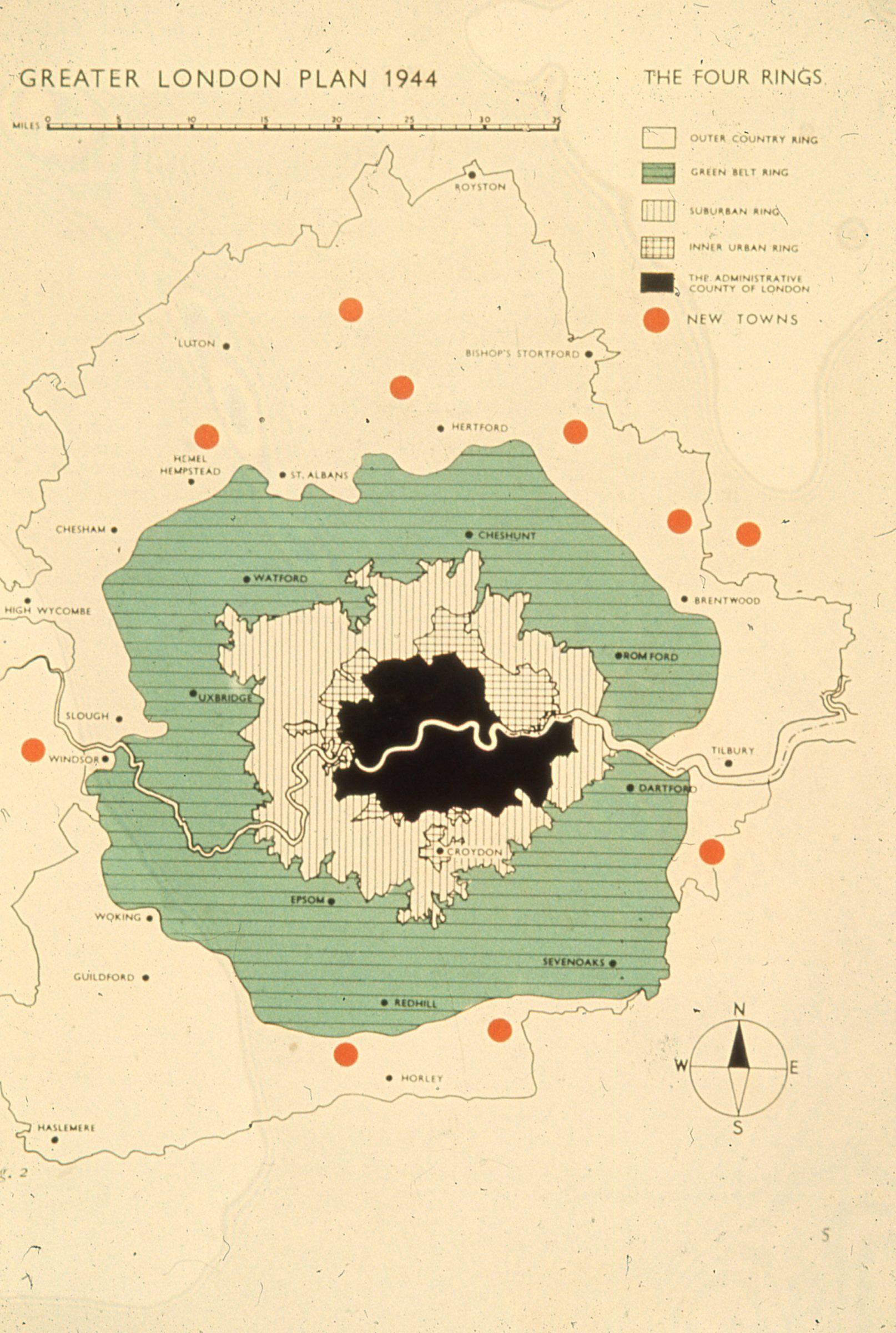
Patrick Geddes’ ideas found practical application and further development through the work of his followers, particularly in Britain and the United States. In Britain, planners like Patrick Abercrombie and George Pepler sought to integrate Geddesian principles into their work. Abercrombie, inspired by Geddes’ biological framework, argued that regional health depended on the interaction between people and their environment, as well as a balanced urban-rural relationship. Following the 1919 Housing Act, Abercrombie contributed to establishing the Regional Planning Departmental Committees by 1921, emphasizing the sociological understanding of place and people. He promoted Geddes’ social reconstruction doctrine, advocating for civic societies, university reform, and the League of Nations as a platform for postwar cooperation, elevating the planning profession’s social significance. As head of the Department of Civic Design at Liverpool University and editor of the Town Planning Review, Abercrombie combined Geddesian regional survey methods with pragmatic insights, as seen in projects like the Doncaster and Sheffield Regional Planning Schemes. His most notable work, the Greater London Plan, innovatively integrated Geddesian principles with neighborhoodunit concepts and road hierarchies, featuring concentric rings of decreasing density and a hierarchical road system that reflected an organic approach to urban growth. Similarly, George Pepler embraced Geddes’ ideas, contributing to the institutionalization of regional planning in Britain.32, 33
Jaqueline Tyrwhitt, a British planner, editor, and educator, played a pivotal role in reviving and advancing Patrick Geddes’ planning theories, ensuring their relevance in post-World War II urban planning. Inspired by Geddes’ bioregionalism, which emphasized the interconnectedness of people, place, and work, Tyrwhitt adopted his principles of “survey before plan”
and “conservative surgery,” advocating for incremental improvements over large-scale demolition. She edited and abridged Geddes’ works, such as Cities in Evolution (1949) and Patrick Geddes in India (1947), making his ideas accessible to a broader audience.34 Her work with the United Nations, especially in India, applied Geddes’ principles to local contexts, such as village centers and community development. At the same time, her contributions to planning education at institutions like Harvard and the Bandung Institute of Technology embedded his ideas into curricula worldwide.35
In the United States, Patrick Geddes’ ideas gained prominence through Lewis Mumford, who became one of his most influential disciples. Introduced to Geddes’ social reconstruction doctrine by Victor Branford during a 1920 trip to London, Mumford returned to the U.S. and, alongside architects, environmentalists, and social commentators, critiqued the New York Regional Plan for its focus on metropolitan expansion and resource exploitation. In 1923, Mumford co-founded the Regional Planning Association of America (RPAA) with Clarence Stein and others, advocating for planning that integrated local history, culture, and ecology. The RPAA promoted sustainable, communityoriented urban development, challenging the prevailing technocratic models of the time.36, 37 Mumford’s work extended Geddes’ legacy into the New Deal era, influencing federal initiatives like the Tennessee Valley Authority (TVA) and the Greenbelt Towns project. The TVA embodied Geddesian principles by combining environmental management, infrastructure development, and social equity to revitalize the Tennessee Valley. The Greenbelt Towns project aimed to create self-sufficient communities that balanced urban and rural elements. These initiatives highlighted the enduring relevance of Geddes’ ideals, emphasizing ecological harmony and social responsibility in regional planning.38, 39
Conclusion
Patrick Geddes’ legacy has grown significantly throughout the 20th century, particularly as a practical framework for reconciling “place” with “people” in fields such as urban planning, education, and ecology. His interdisciplinary approach, rooted in 19th-century positivism, sought to bridge the gap between scientific inquiry and practical application. However, his grand, ambitious social theories often clashed with academic rigor, drawing criticism from specialists in biology, sociology, geography, and planning. His unconventional methods, including his survey techniques and “thinking machines,” were viewed as overly personal and lacking academic precision, which limited their acceptance in scholarly circles.40
Despite these criticisms, Geddes’s emphasis on cultural evolution and regionalism inspired planners across Britain, Europe, India, and the United States. His focus on the interplay between social processes and spatial form, his advocacy for regionalism, and his holistic, people-centered approach to planning have left a lasting impact. Today, Geddes’s work continues to inspire contemporary movements in ecological urbanism, regional planning, and community development. His enduring relevance lies in his pioneering efforts to understand the complex dynamics of urban life and cultural evolution, offering a timeless framework for addressing the challenges of sustainable and equitable urban development.
Notes
1. Meller, H. (1990). Patrick Geddes: Social evolutionist and city planner. Routledge.
2. Goist, P. D. (1974). Patrick Geddes and the city. Journal of the American Institute of Planners, 40(1), 31–37. https://doi.org/10.1080/01944367408977444
3. Ibid
4. Boardman, P. (1978). The worlds of Patrick Geddes: Biologist, town planner, re-educator, peace-warrior. Routledge.
5. Kitchen, P. (1975). A most unsettling person: The life and ideas of Patrick Geddes, founding father of city planning and environmentalism. Saturday Review Press.
6. Welter, V. M. (2002). Biopolis: Patrick Geddes and the city of life. MIT Press.
7. Boardman, P. (1944). Patrick Geddes: Maker of the future. University of North Carolina Press.
8. Goist, 2007.
9. Ibid
10. Bromley, R. (2017). Patrick Geddes and applied planning practice. Landscape and Urban Planning, 166, 82–84. https://doi.org/10.1016/j.landurbplan.2017.08.002
11. Batty, M., & Marshall, S. (2017). Thinking organic, acting civic: The paradox of planning for cities in evolution. Landscape and Urban Planning, 166, 4–14. https://doi.org/10.1016/j. landurbplan.2016.06.002.
12. Eisenman, T. S., & Murray, T. (2017). An integral lens on Patrick Geddes. Landscape and Urban Planning, 166, 43–54. https://doi.org/10.1016/j.landurbplan.2017.05.011
13. Meller, 1990.
14. Geddes, P. (1915). Cities in evolution. Williams & Norgate.
15. Steiner, F., & McSherry, L. (2017). Observation, reflection, action. Landscape and Urban Planning, 166, 55–56. https://doi.org/10.1016/j.landurbplan.2017.06.022
16. Interview: ECR Prize 2022 winner Harry Parker on the regional survey movement. (2022). Patrick Geddes - History of the Human Sciences. Retrieved from https://www.histhum.com/ tag/patrick-geddes/.
17. Parker, H. (2023). The regional survey movement and popular autoethnography in early 20th-century Britain. History of the Human Sciences, 36(3-4), 3-26. https://doi. org/10.1177/09526951231167038
18. Patrick Geddes Collection. (2024). University of Edinburgh Archives. Retrieved from https:// archives.collections.ed.ac.uk/repositories/2/resources/85270
19. Haworth, R. (2011). Patrick Geddes’ concept of conservative surgery. Architectural Heritage, 22(1), 37–42. https://doi.org/10.3366/arch.2011.0004.
20. Steiner & McSherry, 2017.
21. Goist, 2007.
22. Clavel, P., & Young, R. (2017). “Civics”: Patrick Geddes’s theory of city development. Landscape and Urban Planning, 166, 37–42. https://doi.org/10.1016/j. landurbplan.2017.06.017
23. Hysler-Rubin, N. (2011). Patrick Geddes and town planning: A critical view. Routledge. 24. Goist, 1974.
25. Hall, P. (2002). Cities of tomorrow: An intellectual history of urban planning and design in the twentieth century (3rd ed.). Blackwell.
26. Goist, 1974.
27. Geddes, 1915.
28. Goist, 1974.
29. Bromley, 2017.
30. Meller, 1990.
31. Ibid.
32. Ibid.
33. Hall, 2002.
34. Shoshkes, E. (2017). Jaqueline Tyrwhitt translates Patrick Geddes for post-World War II planning. Landscape and Urban Planning, 166, 15–24. https://doi.org/10.1016/j. landurbplan.2016.09.011
35. Meller, 1990.
36. Lubove, R. (1967). The urban community: Housing and planning in the Progressive Era. Englewood Cliffs: Prentice Hall.
37. Mumford, L. (1982). Sketches from Life: The Autobiography of Lewis Mumford: The Early Years. New York: Dial Press.
38. Meller, 1990.
39. Hall, 2002.
40. Meller, 1990.
Marjorie Sewell Cautley: Landscape Planner for Better Social Life
Lillian Chung Kwan Yu
Early Years – Embarking The Journey Pioneering
Marjorie Sewell Cautley was born to a middle-class Navy family in August 1891 at Mare Island near San Francisco, California. Her father William “Elbridge” Sewell was a Lieutenant in the Navy while her mother, Minnie Sawyer Moore, was an accomplished painter of native Californian flowers.1 At a young age, Marjorie was encouraged to read, to write, to paint, and to do gardening. The peripatetic naval lifestyle laid the foundation of Marjorie’s childhood, giving her early life a sense of freedom. She spent her early
years in California, Yokohama, Japan, and New York. In 1902, Marjorie departed to Guam in the South Pacific with her two sisters after their father’s appointment as Guam’s governor.2 A year in the South Pacific left her with lifelong memories of natural beauty and respect for natural forces, which laid the groundwork for her path to landscape architecture. Yet Marjorie’s carefree and unfettered childhood ended abruptly with the death of her mother when she was 10, followed with her father’s passing three years later.
While living with relatives in New York, Marjorie was enrolled in the Packer Collegiate Institute in 1904, and attended weekend classes at the Pratt Institute, an industrial arts school offering courses in architectural drawing, woodcarving, textile design, and other vocational skills.3 Her talent in writing gradually emerged with the publication of her first article, “The Majic of Guam,” in the Atlantic Monthly.4 Contemplating on career options, Marjorie decided to be self-reliant by gaining professional skills. At the age of 23, she enrolled in the landscape architecture program at Cornell University, which was one of a few colleges offering landscape architecture programs for women at that time. Shortly after graduating from Cornell in 1917, Marjorie went to work for landscape architect Warren H. Manning in Boston and then architect Julia Morgan in Illinois.5 These early work experiences enriched Marjorie’s understanding of housing design as well as planting design in residential landscape, which would become a major component in her lifelong professional practice spanning landscape architecture and planning.
Practitioner in Landscape Architecture
Raised in the Progressive Era and in a civil servant family, Marjorie Cautley’s design was associated with a strong sense of social responsibility, believing landscape architects should serve civic purposes as well as the power of good design to improve life. She envisioned leveraging landscapes to suit
affordable housing and spaces for outdoor enjoyment.
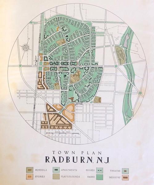
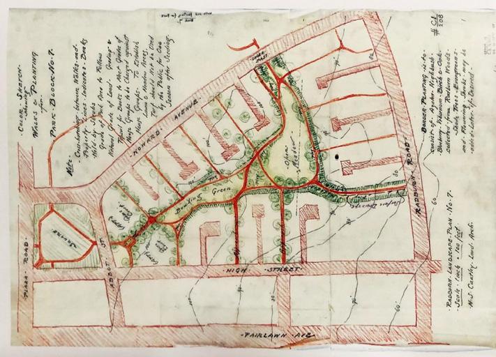
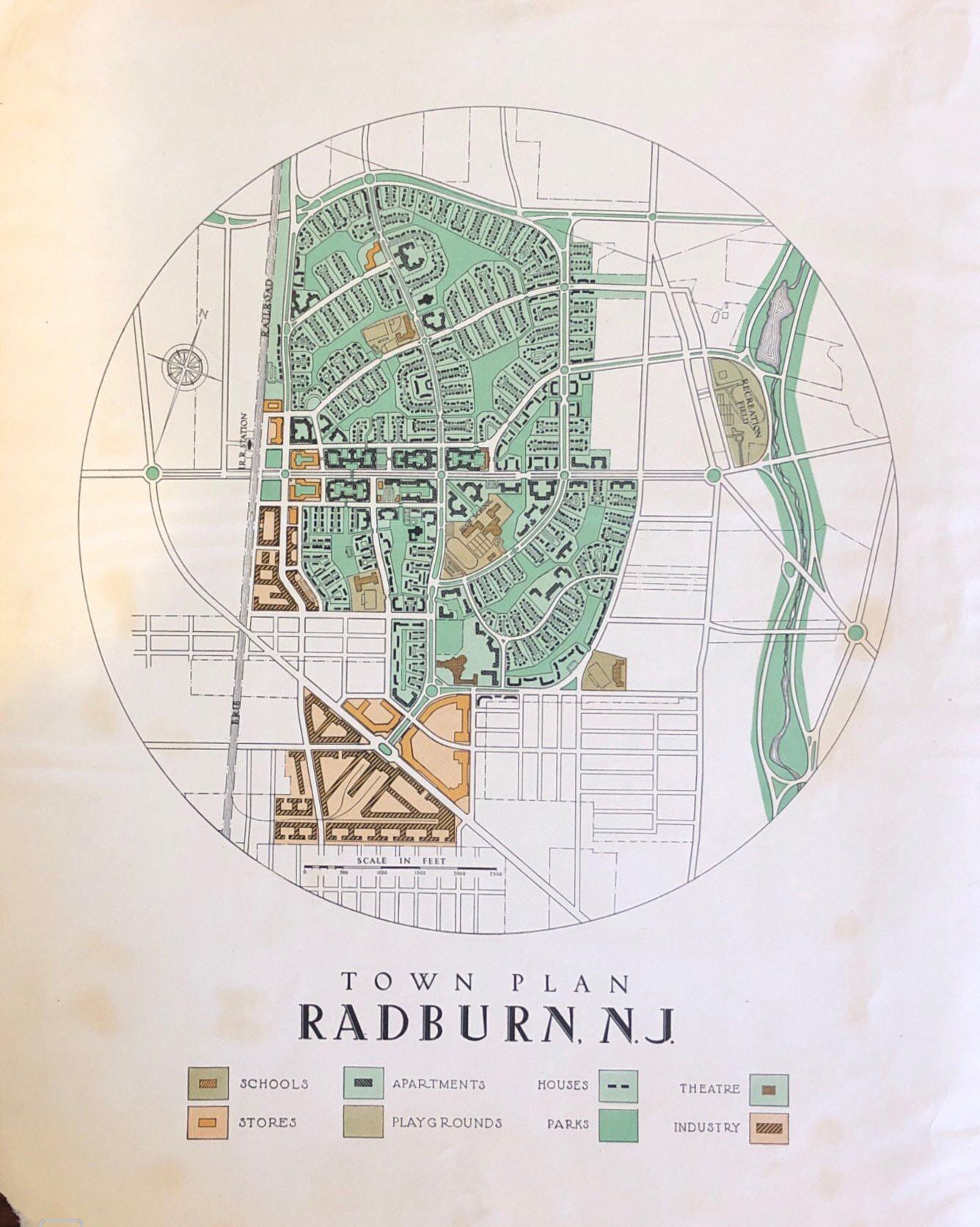
Cautley launched her own practice in New Jersey in 1920, specializing in public projects, including housings, schools, parks, and so on.6 With the rise of automobiles in the 1920s, there were interests in the development of livable cities that supported the family lifestyle combining the advantages of green spaces, modern technology, and transportation. To ameliorate the national housing crisis, Clarence Stein together with his colleagues, including Robert D. Kohn, Henry Wright, Charles Harris Whitaker, Frederick L. Ackerman, Benton MacKaye, and Lewis Mumford, organized as the Regional Planning Association of America (RPAA) and attempted to introduce American Garden City, loosely based on the idea of the English urban planner Ebenezer Howard as proposed in his 1898 book Tomorrow: A Peaceful Path to Real Reform.7 Clarence Stein and Henry Wright’s work of Sunnyside superblock in Brooklyn, New York (1924-1928) and Radburn, New Jersey (1928-1930) has a longlasting legacy. Cautley oversaw the landscape design and setting for both projects in conjunction with a team of architects led by Stein and Wright. Most people credited Cautley for her planting design on Radburn, yet she also played a crucial role in site organization and planning. She drafted both the landscape and planting plans for Allen Place and “Radburn Landscape Plan
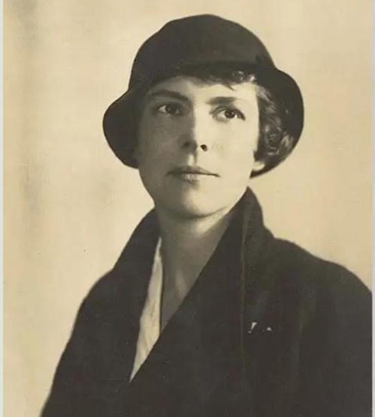
Marjorie Sewell Cautley by her late 30s. #4908, Division of Rare and Manuscript Collections, Cornell University Library.
“Town
Plan, Radburn, New Jersey.”
Marjorie Sewell Cautley Collection, The Architectural Archives, University of Pennsylvania.
No.7,” exemplifying her role in shaping the experiences in the neighborhood spaces.
As a practitioner, Cautley demonstrated sensitivity to environmental conditions for siting and landscape design. Her design process was generally guided by a careful and close observation of existing site conditions, including topography, soil, climate, and vegetation, in order to preserve and enhance the vitality of natural systems in place.8 She also emphasized the use of native or naturalized plants that were adapted to local climate for aesthetical, economic, and ecological benefits.9 On the other hand, as a mother, Cautley inscribed feminist care spatially to women and kids. At the Sunnyside, she planned gardens considering a balance between household privacy and the social need. This resulted in an even finer attention to the location of spaces for domestic tasks. In Radburn’s masterplan, the siting of schools and schoolyards was designed to be within “watchful eyes” for neighborhood safety.
Since the late 1920s, Cautley changed her professional title from landscape architect to landscape designer, possibly suggesting her expanding role in
planning of public landscapes.10 Her collaboration with Stein continued in Phipps Garden Apartments in Queens, NY (1931) for low-income residents and Hillside Housing in the Bronx, NY (1931-35).
Later Years & Legacy
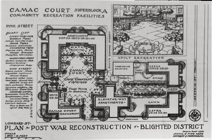
At the height of her career, Cautley suffered from a nervous breakdown. After being released from institutionalization in Greystone Park in New Jersey in 1941, she planned to resume her career as a city planner. With the openingup of female admission to universities, Cautley was enrolled into the Master of Fine Arts degree in City Planning at the University of Pennsylvania at the age of 52 to focus her study on housing and city planning.11 Her thesis project “Post War Plans for Reconstruction of a Blighted District in Ward 7-V, Philadelphia, Pennsylvania,” focused on the transformation of a deteriorating neighborhood near City Hall into “Camac Court”.12 In the proposal, modern housing – modeled after the superblocks of Radburn, each encompassed a central courtyard with an outdoor café in one block and a linear water fountain for play in another block. This envisioned a way to introduce vibrant lowincome housing in Center City and encouraged social life.
In one of the most transformative times in the history of American landscapes, Cautley’s work spanned between private and public, between nature and social, between large-scale to meticulous design decisions, and between landscape architecture, gardening, and planning. Within her relatively short 20-year professional practice, she significantly contributed to the thinking of housing and parks for public well-being and in relation to the arrival of automobiles, leaving a legacy of socially and environmentally sensitive work that her fellow practitioners aspire to today.
“Radburn Landscape Plan No. 7,” December 20, 1928. Marjorie Sewell Cautley Landscape Drawings, 19281931, Avery Architectural & Fine Arts Library, Columbia University.
“Plan for Post War Reconstruction of a Blighted District,” The American City, October 1943.
Notes
1. Sarah Allaback, “EARLY YEARS,” in Marjorie Sewell Cautley: Landscape Architect for the Motor Age (Library of American Landscape History, 2022), 9–10.
2. Allaback, ““EARLY YEARS,” 13-14.
3. Allaback, ““EARLY YEARS,” 15.
4. Allaback, ““EARLY YEARS,” 16.
5. “Marjorie Sewell Cautley,” The Cultural Landscape Foundation, accessed February 16, 2024, https://www.tclf.org/pioneer/marjorie-sewell-cautley
6. Thaïsa Way, “Chapter 10 Garden City Landscapes of Marjorie L. Sewell Cautley, 19221937,” in Women in Landscape Architecture: Essays on History and Practice, ed. Louise A. Mozingo and Linda Jewell (McFarland & Company, Inc. Publishers, 2012), 138.
7. Way, “Chapter 10,” 137.
8. Marjorie Cautley, “Landscaping the Housing Project,” magazine article, 1935, Folder 142.8, Marjorie Sewell Cautley Collection, The Architectural Archives, University of Pennsylvania.
9. Cautley, “Landscaping the Housing Project,” 1935.
10. Sarah Allaback, “LANDSCAPES FOR THE MOTOR AGE,” in Marjorie Sewell Cautley: Landscape Architect for the Motor Age (Library of American Landscape History, 2022), 67.
11. The Cultural Landscape Foundation, ““Marjorie Sewell Cautley.”
12. Sarah Allaback, “LATER YEARS,” in Marjorie Sewell Cautley: Landscape Architect for the Motor Age (Library of American Landscape History, 2022), 148-149.
J.B. Jackson: Vernacular Landscape
Suhyun Kim
Brinckerhoff “Brinck” Jackson
John Brinckerhoff Jackson (1909-1996) was an author, editor and educator. He was born in France and was educated and raised in France, Switzerland and the U.S. He studied history and literature at Harvard, spent a year at MIT and worked as a reporter. John Brinkerhoff Jackson taught at Harvard and Berkeley, sometimes driving his motorcycle between them. He later settled in New Mexico, where his uncle lived. During World War 2, he served as a field intelligence officer, which led to his interest in landscape. He was influential in establishing the concept of landscape in its modern sense. His writings focus on the changes in urban and rural landscapes, the relationship between humans and the environment, and exploring the meaning of vernacular landscapes.
J.B.
Jackson’s
life and educational background John
Jackson’s parents were diplomats and that resulted in him spending his childhood moving between Europe and the U.S. In 1923, at the age of 14, he attended a private boarding school in Switzerland, where he became proficient in French and German. He enjoyed the natural surroundings and would later draw and write about them. Afterward, he attended school in New England and spent summers on his uncle’s farm in New Mexico. He later attended the Experimental College of the University of Wisconsin-Madison and there, he developed his ideas about landscape. In 1929, he began to study at Harvard. In this time, he started to focus on Baroque style and history, and he believed that the zest of the Baroque style was the essence of the connection between humankind and nature. While he was studying at Harvard, he started to write articles, and this became the foundation that inspired him to write about landscapes later on.
World War 2 and Landscape
J.B. Jackson ran a ranch in New Mexico before enlisting in the army, and his military enlistment record lists him as Civil Occupation: Farm hand, animal and livestock, indicating that he did farm labor involving animals and livestock before the war.
Before deploying to Europe, he completed a correspondence course at Fort Bliss, became a second lieutenant, and was sent to Fort Riley, Kansas, where he trained cavalry soldiers for about six months. After Pearl Harbor, Jackson was assigned to Washington, D.C., where he worked in the Munitions Building,
Source: Cook, 19901
reading incoming dispatches and relaying essential information to generals and their staff. He then trained for intelligence work at Camp Leach in Maryland before being sent on active duty in North Africa and Europe. He served in North Africa, scouting and mapping the front lines. In Sicily, he worked to interrogate German prisoners of war, and after the Normandy landings in France, he served as an intelligence officer, conducting reconnaissance and intelligence missions in Belgium and Germany.
During his military service, he painted local landscapes, churches, villages, and other scenes. His drawings range from operational sketches to nonmilitary paintings, which show his interest in landscape. In addition, letters he wrote during the war describe the destruction of the city. He was discharged from the army on September 12, 1945.
While looking at maps as a strategic tool, he must have seen the landscape in its many dimensions, sometimes two-dimensional or three-dimensional. The contrast between the war-torn landscape and the maps must have been a great inspiration to him. For him, the experience of war is considered sufficient to provide a path for how the Landscape should be preserved and viewed.
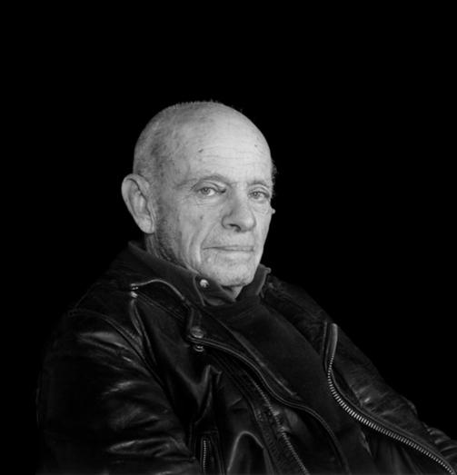
Figure 1 J.B. Jackson in Cienega
Landscape
After the end of World War 2, in 1951, he published the first issue of Landscape. It was subtitled Human Geography of the Southwest. Jackson served as a publisher and an editor until 1968. Initially, he wanted to discuss his view of the world through aerial photography, which was clearly derived from his military experience. Jackson states that “It is from the air that the true relationship between the natural and the human landscape is first clearly revealed. The peaks and canyons lose much of their impressiveness when seen from above. What catches our eye and arouses our interest is not the sandy washes and the naked rocks, but the evidences of man.”
His magazine was centered on what he called the “Vernacular Landscape.” He intended to discuss the ability of a small group of people to change their surroundings significantly. Until he finished his role as a publisher and editor of Landscape in 1968, his magazine raised questions about the role of people in the formation of landscapes.
Vernacular Landscape
“The drama of New Mexico’s attraction and conquest is being continued, and we are in the fortunate position of being able to observe and record that wave of optimistic expansion and discovery.”3
Instead of focusing on traditional landscapes, he begins to talk about landscapes that are more mundane and include human-altered landscapes. J.B. Jackson defines vernacular landscapes as places where there is little or no spatial order shaped by government or institutional planning. He explains the concept of “political” as spaces and structures that impose unity and order on the land or are shaped by long-term, large-scale planning.
Source: Bert Brandt,1944
Figure 2. Photo of J.B. Jackson
J.B. Jackson says the vernacular landscape is made by ordinary people in ordinary places, in ways that are not necessarily planned or designed, but reflects the culture and the needs of those who create them.
According to J.B. Jackson, a landscape is not only a feature of the natural environment, but an artificial space, a human-made spatial system on land. He also describes it as intentionally shaped for the community, rather than operating and evolving according to natural laws. One thing that is consistently agreed upon across all generations and perspectives is the collective nature of landscapes: they are spaces that are intentionally created to accelerate or slow down natural processes. This means that humans take on the role of time for themselves. Jackson wanted to expand the concept of landscape beyond just natural landscapes to include human-made and social spaces. He wanted to include elements such as agricultural landscapes, road networks, and towns alongside everyday living spaces.
When we think of “landscape,” we tend to think of it as something that exists in its natural state. However, landscapes are human-made spaces: parks, urban forests, farmland and gardens. Perhaps a landscape is not something that nature has created on its own, but rather a spatial system that humans have intentionally created.
Landscapes are not just decorative; they regulate changes in nature. Jackson sees designing landscapes as also about manipulating the passage of time. For example, planting a forest can create greenery much faster than it would take for nature to create a forest on its own. Conversely, covering a stream with concrete can slow or even stop the natural process of erosion. This way, humans can control the pace of nature through the landscape.
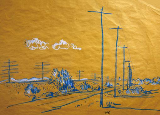
Figure 3. Telephone Pole, Source: Jackson, 1947
Author’s own
Figure 4. Vernacular Landscape in New Mexico 1
Author’s own
Figure 5. Vernacular Landscape in New Mexico 2
Conclusion
Jackson’s writings and research have contributed to a greater understanding of “ordinary spaces” in landscape and urban design today. He was instrumental in shaping the course of modern landscape and urban research, particularly in the study of mobiles, suburbanization, road network, and the transformation of rural landscapes.
Traditional landscape studies focused on intentionally designed spaces, such as parks, gardens and monumental architecture, but Jackson questioned this approach, arguing that the landscapes that people encounter every day are essential to understanding modern society. He argued that unlike in Europe, American landscapes are not planned, but rather gradually formed, and that ordinary spaces such as roads, parking lots, suburban homes, billboards and rural landscapes are the ones to study. He argued that unlike traditional urban designers’ negative view of suburbanization, we should acknowledge that suburban landscapes have their own logic and order.
Jackson saw landscapes not just as physical spaces, but as social spaces where power, class and economic interests exist. He questioned who creates, transforms, and manages landscapes, emphasizing that they are more than just aesthetics, but are intimately connected to social structures. By considering how we read and interpret landscapes, he argued that we need to expand the way we look at space, paying particular attention to temporal landscapes and exploring the possibility that abandoned spaces can be reimagined in new ways. This made a major impact on sustainability and urban regeneration research.
Notes
1. Cook, M. (Photographer). (1990). J.B. Jackson in Cienega [Photograph]. Charles Saumarez Smith. https://charlessaumarezsmith.com/2017/07/18/john-brinckerhoff-jackson/.
2. Jackson, J. B. (1984). Discovering the vernacular landscape. Yale University Press.
3. Jackson, J. B. (1997). Landscape in sight: Looking at America. Yale University Press.
4. Jackson, J. B. (1980). The necessity for ruins, and other topics. University of Massachusetts Press.
5. Creighton, M. R., & Paiva, J. (Eds.). (2010). Traces of J. B. Jackson: The man who taught us to see everyday America. University of Virginia Press.
6. Cook, M. (Photographer). (1990). J.B. Jackson in Cienega [Photograph]. Charles Saumarez Smith. https://charlessaumarezsmith.com/2017/07/18/john-brinckerhoff-jackson/.
7. Jackson, J. B. (1947). Telephone poles, American Southwest [Drawing]. In Drawn to landscape: The pioneering work of J. B. Jackson slideshow. Foundation for Landscape Studies. Retrieved from https://www.foundationforlandscapestudies.org
8. Wilson, C., & Groth, P. (Eds.). (2003). Everyday America: Cultural landscape studies after J. B. Jackson. University of California Press.
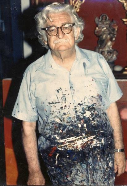
Marcus Owens Roberto Burle Marx
Until the 20th century, the modern Brazilian city developed with an antagonistic relationship with the natural environment. Green spaces remained exclusive to parks and garden within wealthy neighborhoods. This spatial history is a remnant of cultural patrimony by a cannibalistic Portuguese aristocracy displaced by Napoleon. Brazilian state policy formed out of Prince Regent Joao and his grandson Joao VI in the 19th century as they created new cultural institutions to enhance the economic standings of the colony. Statesponsored buildings, plazas, parks and acclimatization gardens defined a cultural patrimony inherent in Brazilian state policy. The Jardim Botanico, which would later become the Museu Real in Rio de Janeiro, exemplify a royal agenda fixated in conservation and propagation of tropical plants and architecture from Portuguese colonies. These gardens, which employed French seeds and water lilies from New Guinea and royal palms, stood as international displays of floral wealth and the modern vision of a regal Brazilian landscape. Collection and exploration of Brazil’s interior would spur several state-sponsored European scientific expeditions, Missao Artistica Frecesca and the Missao Cientifica Austriaca, influencing royal and public gardens of Brazil with a preoccupation with the English picturesque garden. This influx of European artists would lead to French architect, Francois Marie Glaziou, to direct the Parques e Jardins da Casa Imperial. This drastically transformed the urban parks and plazas of Rio. Pedro II would continue to reforest Rio’s entire watershed and Floresta da Tijuca, the largest urban forest in the world. Glaziou would design the Campo da Aclamacao around the Museu Imperial and the Largo do Machado with the Igreja Nossa Senhora da Gloria in Rio de Janiero in 1906. This period between 1890 and 1930 would be known as the Republica Velha, when “nationalism, industrialization, urbanization, immigration, and a developmental vision of expansion and settlement throughout the Brazilian territory increased rapidly.”1 Social change through emancipation in 1888, establishment of the Ministerio de Agricultura in 1906, and the popularity of Positivism in Brazil’s middle class marked a tension in state concerns over education, science, and culture with a burgeoning nationalist spirit.
Roberto Burle Marx Origins
Roberto Burle Marx was born in 1909 to Cecilia Burle and Milhelm Marx in Sao Paulo. Roberto was fed German magazines on parks and gardens in other countries by his father, while learning to tend to plants under the guidance of his mother. Brazilian intellectuals frequented his home further educating Roberto on Dutch and German gardeners. Milhelm brought Roberto to Berlin until the age of 19 and 20 at the height of Germany’s boom in artistic modernism. As Roberto was drawn to music and experimental theater, he tended to pursue music and painting. Burle Marx would pay regular visits to the Berlin-Dahlem
Botanical Garden, enchanted by the work of Auguste Francois Marie Glaziou, a French engineer and botanist that blended native and foreign vegetation. Although he would later become a landscape architect, perhaps Burle Marx’ attraction to music and painting afforded his thinking about gardens. The ecological and botanical lessons he drew from French modernist works by Pablo Picasso, Joan Miró, Paul Klee and even Van Gogh offered powerful examples to deconstruct and emulate (Carneiro). Burle Marx recognized the modernizing energy behind foreign Dutch paintings of Brazilian landscape in the 17th century. They identified what moved observers.
Burle Marx would come to study under Candido Portinar, Licilio de Albuquerque,
Roberto Burle Marx 1981
Source: Flickr, San Luis
Obispo
and Leo Putz, increasing his perception of gardens as artistically logical spaces. Within the Berlin-Dahlem Botanical Garden, Burle Marx witnessed the relationship between nature and Brazil’s distant landscape juxtaposed with Brazilian floral wealth directly while living in Germany.2 At Dahlem, Burle Marx absorbed the power of tropical nature. He saw the potential for the creation of associations among plants governed by aesthetic rather than botanical criteria. The indigenous context of Brazilian plants fascinated Burle Marx: the intensity of light, shapes, colors, and textures of different kinds of vegetation combined into an artistic composition. There was also the joy of discovery. Burle Marx would therefore study the hinterland of Brazil, echoing Glaziou and other 19th century foreign naturalists.
Concurrently, from 1890s to 1919, the rural labor force of Brazil began to immigrate after slavery to work with fazendeiros (large estate owners growing cash crops). The emergence of trade unions, strikes, and brasilidade coincide with 19th century Brazilian art slavery and indigenous populations rising to allegorical representation of the nation. The native identity was needed as a way of separating intellectual and political Portuguese origins. Visual idioms sprouted, such as Francisco Pinheiro’s Allegory of the Empire of Brazil, that crafted notions of representations of national identity that resisted a modernist tendency to assimilate and consume Western culture and New World knowledge. These symbols were actively replaced by French and American ideals of whitening the national identity and the black figure is replaced with the colonial martyr of independence. Known as branqueamento, the whitening of the nation was supported through national policy which subsidized European immigration.
From 1900 to 1920, black peoples arrive as agents of their own identity and destiny. Although Brazilian art of this period struggled to be regarded as modern, Tarsila do Amaral’s The Negress stands at the precipice of modernism and characteristically Brazilian art. Roberto Burle Marx worked at a time when Brazilian architects were struggling to throw off the academicism and eclecticism of studying the designs of the European avant-garde, the Bauhaus and Le Corbusier. Burle Marx would go on to complete municipal plazas in Recife, large public parks in Rio de Janeiro, and commissions over 100 private gardens across Sao Paulo. From the 1930s to the early 60s, Roberto’s career utilized these tools of cultural construction to navigate around political elite and right-wing military dictatorship.
The Ministry of Education and Health in Rio was Burle Marx’ first attempt to integrate a garden into a modern architectural ensemble. Led by a mentor, Lucio Costa, and architects Oscar Niemeyer, Affonso Reidy, Carlos Leao, Jorge Moreira, and Ernani Vasconcellos, the ministry headquarters stood as an important modernist undertaking in the Castelo district within a repositioned Estado Novo dictatorial regime. The ministry building was consulted on by Le Corbusier and contracted by Burle Marx for its landscape scheme. The design of the minister’s private roof terrace and public plaza at ground level echoed the picturesque in Glaziou’s public parks and the abstract work of Hans Arp. Public space of the plaza was shaped by traditional pedra portuguesa paving stones and planting beds, evoking a counterpoint to the neoclassical palace. The use of concrete and adjustable quebra-luz (sun shades) along the face of the tower harkened back to Contra’s earlier work on the Pavilhao Brasileiro, both of which integrate landscape and evoke tropical majesty of the Amazon region and native Brazilian vegetation.
The presidential Vargas Era revolution of 1930 instituted several policies that embraced landscape architecture as part of culture. The Codio Florestal Brasileiro (Brazilian Forestry Code) in 1934 and the Servico do Patromonio Historico e Artistico Nacional (SPHAN: Department of National Heritage and Artistic Heritage) in 1937 defined Brazil’s historic and artistic patrimony as “those assets, moveable, or immovable.. whose conservation is of public interest due to their exceptional value.”3 Burle Marx’ tropical landscapes were not only impactful but touched on an international audience as an emblem of a new dialogue between modern architecture and Brazilian nature. Roberto’s early plazas stand as public spaces for civic engagement of a modernizing state.
The state’s support of Codigo Florestal Brasierio extended Vargas’ economic development of the hinterlands. These codes would be rewritten twice in 1960s and the early 2000s, gradually tightening and loosening permissions on extractive mining and forest exploitation. By Vargas’ second presidency, Oscar
A Negra, 1923 - Tarsila do Amaral
Rooftop garden of the Gustavo Capanema Building, the Ministry of Education and Health headquarters, c. 1955
Niemeyer had invited Burle Marx to design a series of ornamental gardens for the Parque do Ibirapuera in Sao Paulo. These were meant to emphasize the state’s rise as an industrial power amidst rapid resource extraction and global trade. This commission would complement Niemeyer’s Palacio das Industrias building. The full breadth of the landscape was never realized, but the plans and goaches submitted for competition withheld a reinterpretation of the courtyard garden. They drew on Sao Paulo’s countryside of native wildflowers, aquatic plants from the Amazon, chromatic floral surfaces, and hidden water jets. Burle Marx argued that the use of, “regional vegetation and mineral resources in the urban setting to sustain the ecological balance… respects local landscape and offers sustainable design solutions.”4 A series of national projects, whose annum would be Brasilia in 1961, adapted Roberto’s conception of resource extraction. Transferring the composition of phytogeographic regions native to Brazil into public parks and plazas would be a strategy for redefining the nationalist vision. He would continue trying to shift the developmentalist agenda of the Forestry Code toward a treatment of the forest as a cultural resource deserving of protection.
These lessons were especially poignant as Burle Marx establishes an office in Caracas, Venezuela from 1956 to 1961. Here, he was commissioned for the landscape design of the Exposicion Internacional de Caracas to showcase the commerce and wealth of Venezuelan flora. The design would consist of a lake with views to the mountains and El Avila National Park, walled patio gardens, and ecological gardens. Parque del Este had influences from the Arab-Iberian courtyards and the visual-environmental relations of a view of Mount Avila captured in a painting by Manual Cabre. These ecological gardens also had a social role embedded in them. By serving as an educational strategy for urbanites, the displacement of nature within the urban public garden and
parallel programming creates intimate spaces for recreation. Burle Marx believed these functions would cement a foundation of cultural and botanical stewardship in visitors. The modern garden’s purpose was not only reflected in the association of vegetation, but the need to promote hygiene, education, and art.5
Burle Marx’ large parks reflect the political programmatic intentions of public space in Latin America. Refurbishment of Sao Paulo’s Praca da Se is a precedent of landscape design agendas that supported an oppressive regime by discouraging public gatherings in the plaza. Vargas’ Estado Novo regime would end with commissions part of a larger national modernization program, including Rio’s Arterro do Flamengo, and Copacabana’s beachfront. Upon returning to Brazil in 1961, the Governor of the Estado da Guanabara, Carlos
Lacerda, would appoint Burle Marx to an advisory work group to coordinate an urban landfill parkway connecting the Santos Dumont Airport with the residential zones of Flamengo and Botofogo Bay. Amidst popular discontent and high inflation, this modern botanical garden was unique from Burle Marx earlier public projects. Flamengo Park’s landscape would be organized as an artificial nature on top of a new topography rather than replicate displaced ecosystems.
The landscape design for Flamengo Park had an abstract style, applying wave motifs on the grass. Portuguese mosaic tiles sit on top of scattered native plants, elucidating a spectacle of perpetual motion. Reflecting on this project reveals how English, Arab, Chinese, and Japanese gardens and Cubists interpretation of landscapes had a great impact on Burle Marx’ designs. The elements of surprise and discovery harken back to traditional English gardens. The emphasis of water that evoke sensory reactions create an emotional resonance with visitors to trigger memory resembling Arab gardens. Finally, the use of minerals and sculpted stones and trees and spiral paths are similar to Chinese and Japanese gardens.6
The geometric form of Flamengo Park would Echo the ornamental garden of Parque do Ibirapuera, foreshadow the patios of Parque del Este, and reinterpret the wave pattern of Copacabana’s beachfront. Without directly reproducing its visage, Burle Marx would capture the mass of the Tijuca and Amazon forests, the sertão, or the coast and manipulate it in his expressions.
Copacabana’s promenade was deeply influential in crafting Brazil’s landscape identity the geometric patterns of the promenade are inspired by indigenous motifs and parallel the waves of the Atlantic. These intentional effects would be the tools of cultural construction of a rapidly modernizing country throughout many years of military dictatorship.
The military coup in 1964 led to the rise of Humberto de Alencar Castelo Branco. After massive civilian protests, prohibitions, such as Institutional Act No. 5 (AI-5) would suspend civilian political rights and excuse political human rights abuses. Burle Marx’ career would transition into environmental advocacy within a federal advisory council established in 1938 and reconfigured with a new nationalist design to suppress radical productions critical of the regime in 1964. Twenty-four counselors represented an aspect of national historic and artistic patrimony and served directly under the Ministrerio da Educacao e Cultura. Although Burle Marx held an incredible platform to influence capital and infrastructure, his appointment to the Conselho Federal de Cultura was ethically compromised. Nevertheless, Roberto developed and asserted seventeen depositions to the plenary council between 1967 and 1973 on the protection of the modern Brazilian landscape.
Burle Marx’ depositions touched on relationship between industrialist greed and climate change, and the preservation of national parks. These concerns were rooted in his observations of Brazilian parks and their rejection of native species. He implored that all Brazilian states have botanical gardens and biological preserves. In 1967, Burle Marx would remark how the extinction of trees in Bahia, Espirito Santo, Minas Gerais, and Amazonia provoke biotic imbalances resulting in poor distribution of rain. The conservation of forests was inextricably linked to climatic changes. In 1969, Roberto would suggest condemning the replanting and reforestation of exotic trees, such as Eucalyptus and Pinus, by real estate developers. These species are prone to catching fire from climate change and don’t protect fresh water sources, soil, flora, or fauna.7 His proposals attempted to meet the physical and mental needs of the population, propose the legislation regarding reforestation around cities, and study restoration efforts of gardens and parks from the 19th century onward.8
Burle Marx would focus on private commissions rather than public projects after the 1970s. He would buy a property in Santo Anrionia da Bica in Barra de Guaratiba, Rio de Janeiro to garden, paint murals, and harvest plants for experimentation. He would continue traveling Brazil’s hinterlands and beaches to collect nature and understand how to arrange various collections of plants. Known as Sitio Roberto Burle Marx, in 1985, the property was added to UNESCO World Monuments Heritage List. Roberto applied several principles into his gardens that combined elements of existing microclimates and the perspective logic of contemporary paintings into his compositions.9 These subsequent projects hint at the emerging understanding of the importance of the public realm to the livability of Brazilian cities. His works also challenged the dominant culture of privately owned public spaces by expanding landscape architecture projects to the public realm. By promoting the modernist narrative of exploration and engagement with the hinterlands within an urban context, Brazilian forestry slowly maintained its cultural significance. Furthermore, Roberto’s series of depositions merged ideas of nature and nationhood as a conservationist strategy at the federal level. Despite progressive reinstitutions of a national Forestry Code which helped
codify natural assets as public heritage, Roberto’s career must be understood as a vital aspect of evoking appreciation of Brazil’s unique landscapes within the realm of the public garden and collective sites of urban education and stewardship.
Notes
1. Nordenson, Catherine Seavitt. (2023). “Large Parks, Statues, and Disfigurement.” Depositions: Roberto Burle Marx and Public Landscapes Under Dictatorship (pp. 147–196), Austin, Texas: University of Texas Press, 154.
2. Sá Carneiro, A. R. (2019). Roberto Burle Marx (1909–94): defining modernism in Latin American landscape architecture. Studies in the History of Gardens & Designed Landscapes, 39(3), 255–270. doi:10.1080/14601176.2018.1529273, 128.
3. Nordenson, 55-106.
4. Ibid., 147-196.
5. Trkulja, T. (2012). Relationship Between Landscape Design and Art in the Work of Roberto Burle Marx, 212.
6. Ibid., 219.
7. Nordenson, 94.
8. Ibid., 104.
9. Trkulja, 214.
10. Lewis, Hepner, A., & Macedo, S. S. (2016). Landscaping Brazil: The Legacy of Roberto Burle Marx. Architectural Design, 86(3), 118–125. doi:10.1002/ad.2054
Ian Lennox McHarg
Yuna Baek
Early Life Experiences
Ian Lennox McHarg was an influential landscape architect and regional planner born and raised in Clydebank, Scotland, in 1920.1 He led an active and productive career, while developing ideas that supported both academia and job industries. Along his unique pathway, he experienced a wide variety of roles that inspired the way his practice evolved. By also imparting his knowledge through academia and research, McHarg had a vision to reform environments, communities, and how humans associated with nature, as he was committed to integrating his understanding of ecology with regional planning.2
Early Life Experiences
Growing up, McHarg made visits a couple of miles away to Glasgow, Scotland, which was different from where he lived.3 His observations of Glasgow prompted him to notice contrasts between Clydebank, recognizing the aesthetics and atmosphere of the “city and countryside,” suggesting his initial exposure to understanding his local surroundings more consciously.4 He also recalled enjoying school, gardening with his mother, and drawing.5 Although he attended high school, he never graduated.6 After dropping out, he took on different roles from a young age, such as being an apprentice, a copy boy for his local newspaper publication, and a soldier.7 After his experience serving in the military for eight years, he attended Harvard’s Graduate School of Design where he graduated with three degrees in landscape architecture and city planning.8
Involvements at the University of Pennsylvania
In his final year at Harvard, McHarg had a discussion with members of the Society of Fellows that made him consider teaching as a profession for the first time.9 A few years after graduating from Harvard, he arrived in Philadelphia to teach at the University of Pennsylvania (Penn); McHarg created and taught courses on campus called “Man and Environment” and “Ecology of the City” where he placed an emphasis on ecology with “human attitudes towards the environment.”10 In addition to these courses, he collaborated with an ecologist to teach a studio course as well.11
Penn established an undergraduate degree in landscape architecture in 1924.12 However, in 1954, G. Holmes Perkins, who was McHarg’s former advisor at Harvard and the Dean of Penn’s School of Design at the time, offered McHarg to lead Penn’s Department of Landscape Architecture, which
would be established the following year.13, 14 In growing and leading the new department, and to further support the department’s curriculum, McHarg invited individuals, some of whom were natural scientists, distinguished lecturers, and national leaders well-versed in the subject of the environment, to become professors alongside him.15 This highlights the importance of opening opportunities for working professionals in educational spaces and McHarg’s hopes in advancing ideas for the next generation of students.
During this time, McHarg was also contributing to the development of a section of Penn’s campus.16 In the 1970s, former Penn president, Martin Meyerson, found appreciation for McHarg’s involvement in his public projects, which permitted the master plan to be initiated on school grounds.17 In turn, McHarg “designed a series of small parks lining Woodland Walk between 36th and 37th Sts.”18 This followed after the closing of Woodland Avenue, which was informally called the McHarg Gardens. In fact, this was not only McHarg’s first project at Penn, but also the “first major planting in this time period.”19
Philosophy
Understanding his initial thought process and values can be traced back to when he worked on his thesis at Harvard. Collaborating with three of his peers, William Conklin, Robert Geddes, and Marvin Sevely, their thesis regarded how “architects, planners, and landscape architects” can recognize the interdisciplinary nature of urban renewal.20 At the same time, they addressed ways to reform the utilization of space (for instance, parking, amenities, and traffic) with the awareness that such spaces were declining.21 This could also have been a method to pave the way for what different patterns can be noticed beyond the architecture discipline. While he and the group focused on Providence, Rhode Island as the specific site for their thesis, it ultimately became “accepted as Central Redevelopment Plan” and “selected as a case study for the 1952 Congrès Internationaux d’Architecture Moderne (CIAM) publication.”22
Ian L. McHarg Collection (109) / Ian L. and Carol McHarg Collection (365), Landscape Architect, 19202001
McHarg also became influenced by others who worked with him. An example was Lewis Mumford, who was McHarg’s mentor and a former Penn colleague.23 Mumford focused on the concept of ecohumanism, which is defined as the “insight into patterns of connectedness among individuals and between individuals and institutions and with the non-human environment.”24 This idea eventually supported McHarg’s background in ecological planning and design.25 With this consideration of placing importance on preparing for an ecological method planning, the process required scientists to carefully scan the area that applied to an orderly and concise set of methods.26 He also formed questions related to ethnography, which can support in assessing the historical context and serve as a foundation for enhancing the culture of a designated space and how people should visit.
McHarg was also interested in science. One day he visited an aerospace company where he assisted in “find[ing] the ideal site for their research endeavors.”27 During his visit, he got the opportunity to observe a scientist experimenting with chlorophyll in the company’s laboratory.28 This experience inspired McHarg to become appreciative of the historical and natural qualities that nature brings, allowing him to ideate how science could further inform his studies. In fact, he was inspired by scientific theories created by Charles Darwin and Lawrence Henderson.29 From the ideas of Darwin and Henderson, McHarg came to understand fit environment, which he defined as “the greatest number of needs of a user were provided by the environment as found, in which the least work of adaptation was required.”30
Another term that was important to his studies was ecology, which he defined as “a study of physical and biological processes, as dynamic and interacting, responsive to laws, having limiting factors and exhibiting certain opportunities and constraints, employed in planning and design for humans.”31 He also mentioned how other living organisms such as plants and animals give references to how space is determined.32 With this, McHarg’s approaches to design included his development of the overlay technique, which considered various social and environmental factors “when determining the location for a facility.”33 This particular method was also used for suitability studies and analyses, which facilitated understanding different aspects of spatial planning.34
McHarg’s “ecological inventory,” which was alternatively known as “the layer cake,” was used to reference “how maps of various components of the biophysical and sociocultural environment in a specific place can be stacked, like a layer cake, to reveal how landscapes function.”35, 36 It was also used in particular circumstances when he needed to understand how a place became the way it is while at the same time be used as a guide to identify problems.37 McHarg mentions in his book Dwelling with Nature that it allows him to see causality when applied to any site.38 By this he emphasizes the importance of considering what happened before and what may happen after to a location, allowing reflection on the process of studying the surroundings, while mitigating factors that could be overlooked when working on a project and for the participating clients. Methods such as this are especially convenient since they ultimately “determine opportunities and constraints for potential land uses,” as well as “the suitability of land uses could be presented to local decision-makers.”39
Collaborations with Administrations
McHarg was involved in administrative tasks outside of the school setting. For example, he collaborated with the National Institute of Mental Health, US Department of Housing and Urban Development, American Institute of Planners, and many more.40 This series of involvements showcases how McHarg has helped in “sustainability policy development that aims to create high-performing landscape designs,” while highlighting his ability to operate at different levels within different administrations.41 These instances further illustrate how McHarg explored deeper ways to bridge more areas of knowledge and perspectives, while understanding the interdisciplinary nature of his work. He also equally cared for the health and well-being of people. His acknowledgment that we as humans should “understand the medium we inhabit as well as how we shape it,” emphasizes how one should be more aware of reflecting on one’s own individual and collective placement.42
Projects
McHarg was involved in numerous projects within various cities across the United States.43 After McHarg became a professor at Penn, he co-founded the Wallace-McHarg Associates with David Wallace in 1962.44 Then, a few years later in 1965, the firm became David Wallace, Ian McHarg, William Roberts, and Thomas Todd (WMRT).45 His firm focused on regional planning and sustainable economic models.46 The following subsections will cover a brief series of both firm-contracted projects and other instances where projects, not contracted with his firm, were worked on by McHarg.
Amelia Island
The Sea Pines Company commissioned WMRT to work for their Florida-based Amelia Island, which consisted of high ground, tidal marsh, and ocean fronts.47 This particular and rather complex planning study needed much scientific analysis and data.48 Therefore, WMRT sub-contracted with another firm.49 In addition, they worked alongside a team of natural scientists and authorities who could provide information relating to the Earth sciences. Altogether, their goals were to “find the optimum fit between man’s habitat requirements in a recreational community and the existing animal and plant ecology and physical conditions.”50
Highways in New Jersey
After hearing news about how residents of “the great megalopolitan corridor between the Delaware and Raritan Rivers in New Jersey” were going to be affected by highway 1-95 in mostly detrimental ways, WMRT was commissioned to work in the area.51 They planned their objectives to have the “least social cost and the maximum social benefit, among which the scenic experience should be considered” that could result in “maximum social utility.”52 Given these circumstances, McHarg also brought forth his methods in organizing social value, along with seeing the kinds of topography that would interrupt highway placement for this project. Eventually, he presented this method to the Secretary of Commerce as well as the Bureau of Public Roads’ Administrator and Senior Staff.53
The Woodlands
WMRT was commissioned to work on the Woodlands, which is a town located near Houston, Texas.54 Commissioned by a developer named George Mitchell, he “wanted to build a master-planned new town of 180,000 residents that would fit in with the environment.”55 Soon, the new town included “commercial, industrial, and recreational developments along with thousands of homes and miles of roads.”56 The process that followed required that McHarg see where the land had to be cleared, built, and which sections had to stay in their natural conditions.57
There was flat land and slow drainage, leading McHarg to propose an open drainage solution that he referred to as “ecological plumbing.”58 In addition, McHarg focused on the land’s hydrology; given that he found that a portion of the area was covered with impervious soils, the strategy going into the project was to have a fair balance of “keep[ing] development away from the highly permeable soils, retain[ing] as much forest as possible, and integrat[ing] open space for surface drainage” along with the removal of pine trees.59
British New Towns
McHarg worked to improve British New Towns; however, this project occurred some years before McHarg’s firm was established.60 McHarg noted that the previous planners of this project “misapplied Garden City density models and disregarded modern use-based programming,” which led to a grand space however lacking “spatial focus” and “the means to promote social engagement.”61 Such conclusions derived from McHarg’s observations highlights the importance of creating an inviting space that creates an opportunity for people to gather and understand the reciprocal relationship between people and spaces. In consideration of the noted issues, he proposed the idea of creating an enclosed courtyard that could be placed at the back or front of the housing unit.62
Conclusion
It is evident that McHarg understood the relevance of integrating subjects such as anthropology, sociology, science, and landscape architecture into his practice in addition to the needs of his communities. Whether it was through his time in education or beyond the academic space, throughout his years the diverse roles he experienced demonstrate how he approached and developed his concepts, philosophy, and research. Along with the characteristics that defined McHarg’s practice and evolving process, examples of his collaborative involvements highlighted the importance of ecological design of spaces for both nature and humans.
Notes
1. McHarg, Ian L. A Quest for Life: An Autobiography. John Wiley & Sons, 1996.
2. Steiner, Frederick. “Healing the Earth: The Relevance of Ian McHarg’s Work for the Future.” Human Ecology Review 23, no. 2 (2017): 75–86. https://www.jstor.org/stable/26367982.
3. McHarg, Ian L. (1996)
4. Ibid. p.15
5. Ibid.
6. Ibid.
7. Ibid.
8. Ibid.
9. Ibid.
10. Ibid. p.158.
11. Spirn, Anne Whiston. “Landscape Architecture, and Environmentalism.” Edited by Michel Conan, 1959.
12. Whitaker, William, and Frederick Steiner. “Ian L. McHarg: an illustrated chronology of his life.” Socio-Ecological Practice Research 1 (2019): 371-380.
13. Kathleen L. John-Alder, “Toward a New Landscape,” Journal of Planning History 13, no. 3 (December 26, 2013): 187–206, https://doi.org/10.1177/1538513213510895
14. McHarg, Ian L. (1996)
15. Palmer, J.A., Cooper, D.E., & Cooper, D. (Eds.). (2001). Fifty Key Thinkers on the Environment (1st ed.). Routledge. https://doi.org/10.4324/9780203440650
16. Thomas, G. E., Brownlee, D. B. (2000). Building America’s first university: an historical and architectural guide to the University of Pennsylvania. United Kingdom: University of Pennsylvania Press, Incorporated.
17. Ibid.
18. See p.1048 of Roman, Lara A., Jason P. Fristensky, Theodore S. Eisenman, Eric J. Greenfield, Robert E. Lundgren, Chloe E. Cerwinka, David A. Hewitt, and Caitlin C. Welsh. “Growing Canopy on a College Campus: Understanding Urban Forest Change Through Archival Records and Aerial Photography.” Environmental Management 60, no. 6 (September 13, 2017): 1042–61. https://doi.org/10.1007/s00267-017-0934-0
19. Ibid., p.1048.
20. McHarg, Ian L. (1996). p.87
21. McHarg, Ian L. (1996).
22. See p. 188 of John-Alder, K. L. (2014). Toward a new landscape: modern courtyard housing and Ian McHarg’s urbanism. Journal of Planning History, 13(3), 187-206.
23. Cohen, W.J. The legacy of Design with Nature: from practice to education. Socio-Ecological Practice Research 1, 339–345 (2019). https://doi.org/10.1007/s42532-019-00026-2
24. See p. 62 of Regal PJ (2002) Ecohumanism: refining the concept. In: Tapp RB (ed) (2002) Ecohumanism. Prometheus Books, Amherst.
25. Cohen, W.J. (2019).
26. McHarg, Ian. “Ecological planning: The planner as catalyst.” Planning theory in the 1980s: A search for future directions, New Brunswick, New Jersey, The Center for Urban Policy Research (1978): 13-15.
27. See p.20 of John-Alder, Kathleen. “A String of Beads, a Pearl, a Howl, a Fear of Silence, and a Patchwork Quilt.” SiteLINES: A Journal of Place 11, no. 1 (2015): 18-20.
28. Ibid
29. Yang, Bo, and Shujuan Li. “Design With Nature: Ian McHarg’s Ecological Wisdom as Actionable and Practical Knowledge.” Landscape and Urban Planning 155 (August 24, 2016): 21–32. https://doi.org/10.1016/j.landurbplan.2016.04.010
30. McHarg, Ian L. (1996). p.183
31. See p. 39 of Theory in Landscape Architecture: A Reader. United States: University of Pennsylvania Press, Incorporated, 2002.
32. McHarg, Ian L. “The place of nature in the city of man.” The Annals of the American Academy of Political and Social Science 352, no. 1 (1964): 1-12.
33. See p. 72 of Burdick, Sarah. “Where to Draw the Line: Using GIS to Incorporate Environmental Data in Highway Placement Decisions.” Carolina Planning Journal 17, no. 1 (1991): 71-74.
34. Ibid
35. See p.107 of Spirn, Anne Whiston. “Landscape Architecture, and Environmentalism.” Edited by Michel Conan, 1959.
36. Steiner, Frederick. (2017) p.77
37. Steiner, Frederick. (2017)
38. McHarg, Ian L., Margulies, Lynn., Corner, James., Hawthorne, Brian. Ian McHarg / Dwelling in Nature: Conversations with Students. United Kingdom: Princeton Architectural Press, 2007.
39. Steiner, Frederick. (2017) p.83
40. McHarg, Ian L. (1996)
41. See p.222 of Bo Yang and Shujuan Li, “Blending Project Goals and Performance Goals in Ecological Planning: Ian McHarg’s Contributions to Landscape Performance Evaluation,” Socio-Ecological Practice Research 1, no. 3–4 (September 3, 2019): 209–25, https://doi. org/10.1007/s42532-019-00029-z
42. Steiner, Frederick. (2017) p.77
43. McHarg, Ian L. (1996)
44. Ibid.
45. Ibid.
46. Black, Brian. “The Nature of Preservation.” Civil War History 58, no. 3 (2012).
47. Roberts, William H., and Jonathan Sutton. “Seeking the Right Environmental Fit for a New Resort Community at Amelia Island, Florida.” Landscape Architecture 63, no. 3 (1973): 239–50. http://www.jstor.org/stable/44677209.
48. Ibid.
49. Ibid.
50. Ibid., p.242.
51. See p.179 of McHarg, Ian. “WHERE SHOULD HIGHWAYS GO?” Landscape Architecture 57, no. 3 (1967): 179–81. http://www.jstor.org/stable/44681101
52. Ibid., p.179
53. McHarg, Ian. (1967)
54. Steiner, Frederick, Dennis McGlade, Carol Franklin, and Niall Kirkwood. “Following Nature’s Lead.” Landscape Architecture 91, no. 7 (2001): 60–97. http://www.jstor.org/ stable/44674884
55. See p.202 of Daniels, Thomas. “McHarg’s Theory and Practice of Regional Ecological Planning: Retrospect and Prospect.” Socio-Ecological Practice Research 1, no. 3–4 (August 9, 2019): 197–208. https://doi.org/10.1007/s42532-019-00024-4.
56. Ibid., p.202.
57. Daniels. Thomas., (2019)
58. See p.1640 of Yang, Bo, and L. I. Ming-Han. “Ecological engineering in a new town development: Drainage design in The Woodlands, Texas.” Ecological Engineering 36, no. 12 (2010): 1639-1650.
59. Daniels, Thomas. (2019), p.203
60. Kathleen L. John-Alder, “Toward a New Landscape,” Journal of Planning History 13, no. 3 (December 26, 2013): 187–206, https://doi.org/10.1177/15385132 13510895.
61. Ibid., p.190.
62. John-Alder, K. L. (2014).
Mary Oliver: Attention As A New Environmental
Ethic of Care
Elizabeth VanDerwerken
Introduction
Mary Oliver’s poetry reflects a new environmental ethic, in which nature is personal, and individual experience becomes the foundation for environmental care. Oliver spent much of her life in Ohio, New England, and Florida, and her work reflects a love of the landscapes local to her home regions. In several of her essay collections, she writes about Transcendentalist and English Romantic writers who were significant literary and philosophic influences on her work. Her writing brings a modern sensibility to the Transcendentalist environmental literature tradition and imbues the natural world with a level of personal intimacy and care in which she invites her readers to take part.
In some works, Oliver bridges observations of the natural world with observations about habitats and species negatively impacted by humans. This engagement with the Anthropocene imbues her writing with a saliency and urgency that sets it apart from other works in the nature genre and brings it firmly into the environmental literary tradition. While this may not be the primary reading of Oliver’s work, such a reading grounds her work within a contemporary environmental context in which climate change, pollution, and habitat loss are acknowledged as scientific and lived reality. Her philosophy of “attention is the beginning of devotion”1 invites her readers to engage on a personal scale in protecting what they love: “I tell you this / to break your heart, / by which I mean only / that it break open and never close again / to the rest of the world.”2 This ethic of environmental care is present throughout Oliver’s work and invites her readers on a personal level to join her in recognizing their own impact on nature and mitigating the negative impacts.
Biographical Sketch
Mary Oliver was born in Cleveland, Ohio, in 1935 and raised in nearby Maple Heights, Ohio. Although she was rather private about her personal life, in occasional interviews and in some of her work she alludes to a difficult childhood and experience of abuse. She writes about retreating to the woods near her home, often missing school to do so, with Walt Whitman’s poetry in hand.4 These usually solitary experiences shaped her views of nature early on. Though she did not receive a college degree, Oliver studied at Ohio State University and Vassar College. Despite her non-traditional education, Oliver was well-versed in the English literary and poetic tradition. In many of her poems and essays she alludes to some of her favorite writers, as well as wrote more extensively about several writers and their own encounters with nature. Oliver was the recipient of several honorary doctorates and she also taught at Case Western Reserve University, Bennington College, Bucknell University, and Sweet Briar College.5
During her life, Oliver also spent time in New York State and lived with her partner Molly Malone Cook in Provincetown, Massachusetts for over forty years. Her memorable encounters with the varied landscapes of Ohio and the northeast are apparent throughout her work. After Cook’s death, Oliver relocated to the coast of Florida, where she spent the remainder of her life. Her first collection of poems, No Voyage, and Other Poems, was published in 1963 and she became a prolific writer, publishing extensively in both poetry and prose until her death in 2019. Her last publication was Devotions: The Selected Poems of Mary Oliver, released in 2017, which anthologizes poems from over the course of her entire career.5
Mary Oliver
Photograph by Molly Malone Cook; courtesy of MaryOliver. com & NW Orchard LLC
Major Works and Career Highlights
Mary Oliver was awarded the Pulitzer Prize in Poetry in 1984 for her book, American Primitive. During her career, Oliver published 28 collections of poems (including several chap books as well as three anthologies: New and Selected Poems: Volumes 1 and 2, and Devotions: The Selected Poems of Mary Oliver), 7 books of prose or essays, and two audio compilations in which Oliver narrates selected works.7 Oliver was also the recipient of many awards, including the National Book Award, Lannan Literary Award, Guggenheim Fellowship, American Academy and Institute of Arts and Letters Achievement Award, and a fellowship from the National Endowment of the Arts.8, 9
Literary Influences and Prevalent Themes
In Oliver’s own writing and interviews, the literary figures which were influential on her personal philosophies are well-documented; William Blake, Walt Whitman, Ralph Waldo Emerson, Edna St. Vincent Millay, Edgar Allan Poe, William Wordsworth, Lucretius, and Rumi are all favorite writers mentioned by Oliver.10, 11, 12, 13, 14 Others have connected Oliver’s writing to the Transcendentalists, with many scholars noting the resonance between her work and Transcendentalist philosophy and naming her a neoTranscendentalist.15, 16 Oliver has also been viewed as a modern analogue or an extension of the Romantic poetry tradition.17
Many writers have placed Oliver’s work in the context of these literary traditions as well as the broader environmental writing tradition, although Oliver herself eschewed such categorization of her work.18 However, such categorizations can provide a useful framework for understanding the common themes of Oliver’s writing. Much of her work reflects a love of nature and observations about nature. A distinct vein of her nature writing, Oliver also has many poems highlighting the human experience of nature, often focusing on qualities like wonder, awe, and reverence and the transcendent, metaphysical qualities of one’s experiences in nature. These poems possess a certain self-awareness, in which the first-person experience is captured in terms of physical experience in the moment, but Oliver simultaneously explores the emotional context that accompanies physical experience.
Oliver was also interested in the technique and craft of writing; she was a teacher and she wrote about being a writer, doing creative work more broadly, and the mechanics of poetry. She also analyzed literature and wrote extensively about writers such as Emerson, Wordsworth, and Whitman. Each of these primary themes present in her work is treated extensively in literary scholarship, but there is a secondary theme present in her work that stands apart from these major themes. Much of Oliver’s work inserts a human presence into nature but often presents an experience of “wild” nature, in which the setting is untouched by human impact. Occasionally her work diverts from this course, and her writings in this vein reveals a sense of urgency consistent with the Anthropocene, in which climate change and human activity are rapidly altering the earth and environment in detrimental ways.
The Anthropocene
Oliver’s book of prose essays Long Life includes an essay titled “Waste Land: An Elegy” in which she writes of the places created by human behavior such
as landfills. Even these places she imbues with a sense of reverence for the forms of life that persist there, in spite of neglect or policy or simply inattention that has created or resulted in them. The essay opens with a description of the dump as a thriving successional meadow, some plants the typical species you might expect in a successional landscape, alongside other plants that have likely arrived from kitchen refuse, this “waste land” home to numerous species of plants and animals:
At our town’s old burn dump, not officially used for years, discarded peppermint and raspberries reconnected their roots to the gravelly earth and went on growing; a couple of apple trees blossomed and bore each year a bushel of green and bumpy fruit. Blackberries drifted up and down the slopes; thistles, Bouncing Bet, everlasting, goldenrod, wild carrot lifted their leaves and then their flowers and then their rafts of seeds. Honeysuckle, in uplifted waves, washed toward some pink roses, no longer a neat and civilized hedge but a thorny ledge, with darkness at its hem. Now the burn dump is no more. The old world had its necessities; presently there are new ones, and they are not so simply met—nor will the old parcels of land suffice. On these few acres of land, and more, will be established the heartland of our town’s sewage, where the buried pipes will converge with the waste of our lives. What a sad hilarity! I want to talk about flowers, but the necessity has become, for our visitor-rich town, how to deal with the daily sewage of, it may be, sixty thousand souls.19
Oliver laments the necessity of infrastructural reality, acknowledging the swelling population of her hometown of Provincetown, Massachusetts on Cape Cod. The burn dump adjoins the Cape Cod National Seashore, a fascinating juxtaposition of recreation activity with the infrastructure that supports it. Oliver continues, describing the animals who had lived on the site and whose residence will be impacted by the expansion of the wastewater facilities:
Soon [the snakes] will be off, hunting another place to live. Which may not be so easy, for the world today is nothing if it is not sprawl, and this not only within the residential areas but the seemingly endless facilities such settlements need. And we do need them. (So, this is an elegy.) Box turtles nested here, and painted turtles also. Out of the shallow ponds below the crest of the hill, snapping turtles crawled to lay their pale, leathery eggs. Raccoons aspire to them; many of the nests were ransacked as soon as the turtle had shuffled away. Foxes left their dainty tracks, and in summer the red-coated deer. 20
Discussions of sprawl and city planning, topics seemingly at odds with much of Oliver’s work. However, this essay reflects the adjacencies present in the modern world, in which very few places are untouched or free of the impact of human settlement and activity. Oliver describes the disturbances which have occurred on this site over many years, the latest iteration of which is the use of the dump as a biking course:
And yet, at certain hours, in the absence of boys and their bikes, I could walk here and see birds I found nowhere else: the indigo bunting, for example, and the black-billed cuckoo. And their more findable associates: goldfinches, catbirds, the brown thrasher, the yellowthroat, palm warblers, the grosbeak. The ruby-throated hummingbird nested here, but even now I will not tell you precisely in what tree. It was a secret to be kept then, so why not keep it still, now that the birds and the tree itself have vanished? 21
This passage captures something of the emotional resonance readers are accustomed to in Oliver’s work, made more poignant here by the acknowledgment that these birds are no longer there, the tree housing their nest long since felled. Oliver’s description of countless bird species she saw in a place that may have seemed to many people inhospitable reflects her minute attention to living creatures, regardless of the cultural perceptions of a specific habitat or place. Oliver next alludes to the reclamation and mitigation methods employed to rehabilitate the former dump for new, productive uses in the broader infrastructural context. The next passage evokes themes of environmental justice; Provincetown with its tourism industry could provide proper protection against environmental contaminants, but many communities may not be positioned as ably to address such needs.
The land itself has been capped against the poisons that have been seeping all these years into the ground, from the fires, from the unknown elements cast away: oils and paints and car batteries and a hundred offensive substances more. And, imagine! for what unaware years I picked the blackberries and the raspberries and thought them sweet and fine—thought them good fortune.22
Oliver concludes the essay acknowledging the contradictions inherent in a modern world that is accountable both to its human population and their needs, as well as to the earth and the other species it supports:
I do not like what has happened. I do not hold the loss lightly. I wish to be reasonable; I know I must be amenable to what is necessary. But—such few choices! I apologize to the hummingbird. I hope the snakes have found a new home. I hope the new system works. I am glad that I have a good memory; I will not forget the dainty tracks of the fox, or the goldfinches, or the everlasting. I think I know what our manifest, tree-filled, creature-lively world is—our garden and our pasture and our recreation. Also it is our schoolhouse, courthouse, church, graveyard, and the soft breath of eternity.
I walk in the world to love it. Only one question, really, frightens me. I wonder why, in all the years I walked in the old burn dump— this waste place, this secret garden—I never met another soul there, who had come forth for a like reason.23
This conclusion echoes the emotional tenor of Oliver’s nature writing—of nature as a place of solace, comfort, and delight. She also questions the lack of notice shown by others, she being the lone visitor to the dump to walk and
to watch the birds and turtles and foxes. Her query is left as a subject for the reader to consider, inviting the reader to question whether they share Oliver’s ethos and whether they, too, would have chosen to “[walk] in the old burn dump,” and by extension, in any place in their own communities which serve as a stand-in—any fragmented habitat arising from human use and disturbance. In another piece furthering this exploration of the Anthropocene, her poem “Lead,” Oliver laments the declining loon population of her harbor town:
Here is a story to break your heart.
Are you willing?
This winter the loons came to our harbor and died, one by one, of nothing we could see.
A friend told me of one on the shore that lifted its head and opened the elegant beak and cried out in the long, sweet savoring of its life which, if you have heard it, you know is a sacred thing., and for which, if you have not heard it, you had better hurry to where they still sing. And, believe me, tell no one just where that is.
The next morning this loon, speckled and iridescent and with a plan to fly home to some hidden lake, was dead on the shore.
I tell you this to break your heart, by which I mean only that it break open and never close again to the rest of the world.
This poem, its title alluding to the unseen cause of death of the loons, resonates with the subject matter of Rachel Carson’s Silent Spring, a work frequently credited with spurring the modern environmental movement. Oliver’s concluding lines of “Lead” evoke a similar ethos as the ending of “Waste Land: An Elegy”—her charge to the reader that they not close their heart to the world, which can be understood to mean the plight of other species impacted or endangered by pollution, climate change, or other environmental perils.
These pieces and their candid acknowledgment of the Anthropocene represent a fascinating but notable departure from Oliver’s primary themes which celebrate and revere familiar landscapes and experiences in them. These writings are imbued with Oliver’s well-known sense of reverence and love for nature, but also reflect a sense of urgency about humans’ place in the world and therefore responsibility to it. Such sentiments fall more squarely in an environmental literary tradition concerned with climate change and the
impact of humans on the planet. The ethos expressed in these works and others are not only didactic in nature—Oliver’s words are charged with a sense of urgency meant to inspire action on the part of her readers.
Conclusion
Gareth Doherty explores the connections between landscape and literature: “Literature helps us see the world and learn about the landscapes in which we live and work, and which we visit, or indeed landscapes we will never visit. Literature reveals aspects of landscape and informs us about them.”24 This secondary theme in Oliver’s work provides a new lens through which to view the rest of her work—our attention takes on new meaning and urgency when placed in the context of our ability to act on protecting what we love. In Oliver’s own words: “The best use of literature bends not toward the narrow and the absolute but to the extravagant and the possible. Answers are no part of it; rather, it is the opinions, the rhapsodic persuasions, the engrafted logics, the clues that are to the mind of the reader the possible keys to his own self-quarrels, his own predicament.”25 Oliver is not prescriptive with specific suggestions for how her readers might engage in the world, but her work is compelling in the way it leaves her reader to ponder its meanings and how they might interpret them in the context of the world and their own actions in service of landscapes and creatures that they love.
2. “Lead” in Oliver, Mary. New and Selected Poems: Volume Two. Boston, Mass.: Beacon Press, 1992.
3. Oliver, Mary. “Mary Oliver: I got saved by the beauty of the world.” Interviewed by Krista Tippett. On Being. February 5, 2015. https://onbeing.org/programs/mary-oliver-i-gotsaved-by-the-beauty-of-the-world/. Accessed February 4, 2025.
Mary Oliver Photograph by Kevork Djansezian / Getty Images; courtesy of Harper’s BAZAAR
5. “About Mary.” MaryOliver.com. https://maryoliver.com/bio/. Accessed February 4, 2025.
6. “Poetry.” The Pulitzer Prizes. https://www.pulitzer.org/prize-winners-by-category/224 Accessed February 11, 2025.
7. “Mary Oliver.” Poetry Foundation. https://www.poetryfoundation.org/poets/mary-oliver Accessed February 4, 2025.
8. Ibid
9. “Mary Oliver.” Poets.org. https://poets.org/poet/mary-oliver. Accessed February 4, 2025.
10. Oliver, Mary. “Mary Oliver: I got saved by the beauty of the world.” Interviewed by Krista Tippett. On Being. February 5, 2015. https://onbeing.org/programs/mary-oliver-i-gotsaved-by-the-beauty-of-the-world/. Accessed February 4, 2025.
11. Oliver, Mary. Long Life: Essays and Other Writings. 1st ed. Cambridge, Mass.: Da Capo Press, 2004, 21-25, 43-51, 90.
13. “Mary Oliver.” Poetry Foundation. https://www.poetryfoundation.org/poets/mary-oliver Accessed February 4, 2025.
14. Oliver, Mary, editor. The Best American Essays 2009. Boston, Mass.: Mariner Books, 2009, xv-xvii.
15. Johnson, Mark. “”Keep Looking”: Mary Oliver’s Emersonian Project.” The Massachusetts Review 46.1 (2005): 78-98. ProQuest. Web. https://proxy.library.upenn.edu/ login?url=https://www.proquest.com/scholarly-journals/keep-looking-mary-oliversemersonian-project/docview/215667799/se-2?accountid=14707. Accessed February 13, 2025.
16. Weiher, Emma Charlotte. “Emerson, I am trying to live…the examined life – The Transcendentalist Poet Mary Oliver.” Current Objectives of Postgraduate American Studies, vol. 23, no. 1, pp. 7-23, DOAJ, https://doi.org/10.5283/copas.354. Accessed February 13, 2025.
17. McNew, Janet. “Mary Oliver and the Tradition of Romantic Nature Poetry.” Contemporary Literature, vol. 30, no. 1, 1989, pp. 59–77. JSTOR, https://doi.org/10.2307/1208424 Accessed 1 Feb. 2025.
18. Johnson, 78.
19. Oliver, Mary. Long Life: Essays and Other Writings, 36.
20. Ibid., 37.
21. Ibid., 38.
22. Ibid., 39.
23. Ibid., 39-40.
24. Doherty, Gareth, Charles Waldheim and Lawrence H. Herring Memorial Fund. Is landscape...?: Essays on the Identity of Landscape. Abingdon, Oxon; New York, NY: Routledge, 2016, 17.
25. Oliver, Mary. Long Life: Essays and Other Writings, 45.
Water Cycle, Layer-Cake Model and Landscape Hydrology: Research About Bruce Ferguson and His Academic Pursuit
Abstract: Among many scholars influenced by Ian McHarg, Bruce Ferguson stands out for his sustained focus on water-related technologies. This article examines Ferguson’s education background, professional trajectory, scholarly publications, and academic contributions, with particular emphasis on the concept of landscape hydrology-a term he introduced, and continuously developed. Drawing upon McHarg’s layer-cake model, Ferguson sought to integrate the water cycle into landscape design framework and interpret the interplay between natural and constructed environments through the lens of hydrological processes. His efforts laid the groundwork for subsequent scholars and practitioners for further developing the theoretical basis of landscape hydrology and expand its application across diverse environmental and urban context.
Key words: Water cycle; Layer-cake Model; Water balance; Mantles; Landscape Hydrology; Bruce Ferguson
Introduction
Bruce Ferguson, Professor Emeritus of College of Environment and Design (CED) in University of Georgia, American Society of Landscape Architects (ASLA) Fellow, an American landscape architect, author, and educator, is known for his research in environmental technologies and their integration in landscape planning and design, and for his work on permeable paving and stormwater management. With numerous achievements, Ferguson is the 1992 winner of the Bradford Williams Medal for the year’s best-written article in Landscape Architecture. He was elected as a Fellow of the ASLA in 1994. The Council of Educators in Landscape Architecture elected him as a Fellow in 2010, and in the same year gave him their Outstanding Educator Award. Also, he served as past President of the Council of Educators in Landscape Architecture.1
As described in a feature review published in Landscape Architecture Magazine, Ferguson’s work has been characterized as “Seeing the World in a Drop of Water.”2 This article examines the relationship between water and landscape, and explores how hydrology, both as a scientific model and a design principle, has been conceptualized, studied, practiced, and advanced within the discipline-particularly through Ferguson’s decadeslong inquiry, advocacy, and experimentation. Educated at the University of Pennsylvania(UPenn), Ferguson’s thinking was profoundly influenced by Ian McHarg’s ecological planning principles. Drawing upon McHarg’s layer-cake
Hailong Liu
model, Ferguson sought to integrate the water cycle into landscape design frameworks and interpret the interplay between natural and constructed environments through the lens of hydrological processes.
If using a concise term to define and describe above efforts, landscape hydrology would be the most appropriate-an expression that Bruce Ferguson has consistently used and advocated since 1980s, grounded in his professional expertise and vision for the future of this interdisciplinary field. Although this term had emerged even earlier in various works, Ferguson was the first to articulate a comprehensive and systematic theoretical framework in his pioneering 1983 paper.3 His definition offered a clarity and coherence that had been lacking in previous research. In Ferguson’s interpretation, landscape hydrology, views the hydrologic landscape as a multilayered system composed of surface water, soil moisture, groundwater, atmospheric condition and cultural intervention-each forming a “mantles “ through which distinct hydrologic processes occur.
Also, by providing a framework for understanding the range of water management and the approaches available for doing it, he attempted to widen the application of this idea in a 1986 paper.4 Major aspects of this framework are the types of functions that management steps perform and the types of environments in which they are practiced. He emphasized that the use of water requires specific attributes-such as quality, quantity, time and placewhich water management seeks to produce either prior to use (to ensure suitability for designated uses) or after use (to make it suitable for discharge into the environment).
In addition, to situate this emerging concept within the broader academic discourse, Ferguson proposed a connection between landscape hydrology and landscape ecology in a 1991 article.5 However, following this series of foundational theoretical contributions, his research trajectory shifted toward small- scale and practice-oriented topics-including landscape construction, stormwater management, pavement technology, and so on. This shift reflected his ongoing efforts to make the abstract theoretical constructs more tangible, applicable and relevant to the real-world challenge.
Education and Career Development
Educated at Dartmouth College and University of Pennsylvania
According to Landscape Architecture Magazine, Ferguson grew up outside Pittsburgh. His undergraduate degree was Bachelor of Arts from Dartmouth College. By checking the current website of Dartmouth College,6 the undergraduate program of Arts and Sciences consist of more than 40 academic departments and programs. Students can combine any of the more than 60 majors with his or her pick of minors; fine-tune a major by adding studies from other departments and programs; or design a special major around students’ particular passion.
Although it is impossible to find curriculum that Bruce Ferguson took almost half a century ago, because the course content might change during several decades, but we can find from the skilled hand drawings, precise interpretation, and specifically the in-depth considerations determining design, such as geology, hydrology, materials and structure in Bruce’s following work, as the
best example of well-training of his education of art and science. Just like the interviewer’s observation to Ferguson as “Those who haven’t met Ferguson might imagine him to be a dry, cerebral technician. But his appreciation of and enthusiasm for the multifaceted nature of landscape architecture is obvious.”2 It’s true that Ferguson’s broad liberal arts education was an integral part of his work and his teaching.
After completing his undergraduate study at Dartmouth in 1971, Ferguson went on to UPenn intending to pursue a master’s degree in architecture, but he discovered Ian McHarg and transferred into the landscape architecture program. After he obtained Master of Landscape Architecture (MLA) from UPenn, the education obtained there and especially the impact from McHarg has led Ferguson’s academic route. According to profile in the Landscape Architecture Magazine, Ferguson mentioned: “my background at McHarg’s Penn gave me an early strength on the natural-resource side of landscape architecture”. But instead of going forward along the general route of Design with Nature, Ferguson proceeded in a different way and tried to find something specific for his academic specialty. He chose water and its related research and practice fields in his academic and career pursuit. He explained that: “the environment as a whole is too big to be expert at; in order to be good at something I had to choose what it would be. My experience in practice soon made clear the importance specifically of water: As I presented every project, someone on the planning commission or elsewhere was vitally interested in water quality, or flooding, or erosion, or water supply, or water conservation.”2
Career Development and Achievement
After obtaining his MLA degree in 1975, Ferguson worked as a land planner in the Washington Center for Design, a thirty-person firm composed of architects, engineers and planners in Washington, PA, and his practices involved land planning, environment impact assessment, and landscape design. After that, he began self-employed consulting in Pittsburg, offering similar professional service for developments and municipalities. From 1980 to 1984, he served as a landscape architect and planner for Pittsburg Field Office of the U.S. Bureau of Mines, Environmental Protection Division, developing methods of watershed planning to guide reclamation of abandoned coal mines and associated acid drainage. During the same period, he took up a position as an instructor at the Department of Landscape Architecture, Pennsylvania State University, teaching environmental planning, site planning and landscape construction to undergraduate students, with associated research and service tasks.1, 7
In 1982 he began working at the School of Environmental Design, University of Georgia, teaching in environmental, technical, and urban design areas of landscape architecture, to both graduate and undergraduate students, in addition to research, service, and administrative tasks, where he eventually became Dan B. Franklin Distinguished Professor of Landscape Architecture.7 During his teaching and research at the University of Georgia, he authored several books, including On-Site Stormwater Management: Applications for Landscape and Engineering, with Thomas N. Debo, PDA Publishers, 1987, 2nd ed., Van Nostrand Reinhold, 1990, Stormwater Infiltration, Boca Raton: Lewis Publishers, 1994, Introduction to Stormwater: Concept, Purpose, Design, New York: John Wiley and Sons, 1998, and Porous Pavements, Boca Raton: CRC Press, 2005 (Fig. 1).8, 9, 10, 11
As an expert on porous pavements and stormwater infiltration in urban design, Ferguson authored numerous scientific and professional articles during his career. His explorations on water projects include multiple purpose stormwater basin,12 shoreline erosion,13 watershed,14 water power,15 and so on. He also edited book reviews of Role of water in urban ecology,16 and constructed wetland.17 Ferguson’s most recent book published in February 14, 2021 was A Philosophy of Landscape Construction, which outlines a new philosophy of values in landscape construction. Within his theoretical framework, he discusses how structures can be designed to articulate spatial, functional, cultural, and ecological meanings, ultimately allowing site designs to reach their full potential. Ferguson’s philosophy moves away from the exclusively technical characteristics and enables landscape architects to realize their designs’ ideal vision while illustrating both successes and failures within built landscapes (Fig.2).18, 19
Fig.1. Books published by Bruce Ferguson from 1987 to 2005
Although Ferguson’s major achievements in recent two decades more relied in practical and technological areas, being more pragmatic and specific to some extent, small-scale and down-to-earth comparing with his earlier theoretical researches and publications, he sees his work in a larger humanist context and his technical knowledge as a means to help people. His interests and publication also went beyond this field and touched the arts and aesthetics in landscape architecture,20 the landscape health,21 and Landscape Architecture of Residences and Residential Communities.22
In his teaching career, before retiring in 2015, Ferguson taught thousands of graduates and undergraduates, led design studios at every level, and took responsible for the college’s vertical charrettes for the Atlanta Highway (2013) and the Atlanta Beltline (2014). In 2019, CED honored Ferguson as one of the College of Environment and Design “Owens 50.”1 In this sense, Ferguson and other likeminded landscape architects influenced by McHarg, are making the impact of Design with Nature toward practical operation. He said: “The problems that I found myself confronted with have been technical,” and added: “For example, a fundamental understanding of how hydrology works in nature made stormwater infiltration an obvious way to restore a natural process with vast human benefits. But in my early work I was prevented from doing it, sometimes by arbitrary technical regulations and sometimes by elaborate technical arguments”.
Everything was not smooth sailing. Ferguson once told the story of his academic life, especially about those difficulties and obstacles he encountered: “I dove into hydrologic technicalities like Beowulf diving into the monster’s lair,” and “I made myself better at the technicalities than those who used them as excuses to avoid thinking about progress.” As noted in the Landscape Architecture magazine, Ferguson chose to grapple directly with these obstacles to more ecologically sound stormwater management, despite difficulties and frustrations along the way. But after years of teaching and writing, he stood by the evidence-based way of thinking, working and writing. However, his work doesn’t finish yet. As he said:“ Today, the trial of technical barrier breaking is behind us. We know what the right thing is to do for water itself. The question now is how to integrate natural process artistically and correctly into the urban landscapes where people live and work.”2
Fig. 2. Bruce Ferguson and his new book published in 2021
Involvement in Teaching at Tsinghua University
In 2003, the Department of Landscape Architecture was established at Tsinghua University in Beijing, China. Notably, as a member of the Laurie Olin chair professor group, Ferguson played an important role in the initial teaching of the department, especially involving the world’s first landscape hydrology course.
The origins of architectural education at Tsinghua can be traced back to the first generation of Chinese architects trained in the United States—Liang Sicheng and Lin Huiyin—both alumni of UPenn. In 1946, they founded the Department of Architecture at Tsinghua, a decade prior to Ian McHarg’s establishment of the Department of Landscape Architecture and Regional Planning at UPenn. Despite they never met, both departments shared a vision of interdisciplinary education.
Landscape architecture education at Tsinghua began in 1951, when the “Garden Design Group” was jointly established by the Department of Architecture of the Tsinghua University and the Department of Horticulture of the Beijing Agricultural University. The idea originated as early as 1949 when Liang Sicheng presented a course classification table that included architecture, urban and rural planning, landscape architecture, industrial design, and engineering. Among them, the scientific and engineering courses in the landscape architecture curriculum included biology, chemistry, mechanics, surveying, materials, engineering (surface and underground drainage), and so on. Later, with the joint efforts of Wu Liangyong and Wang Juyuan in 1951, the “Garden Design Group” initiated the discipline of modern landscape architecture in China. It set a precedent, with profound influences for interdisciplinary landscape architecture education, inspiring for the present day.
Half a century later, in 2003, Tsinghua appointed Laurie Olin—an academician of the American Academy of Arts and Sciences, former chair of landscape architecture at Harvard University, and professor at the UPenn—as the first chair of its new Department of Landscape Architecture. Yang Rui served as executive deputy chair. Between 2003 and 2007, several internationally renowned scholars were invited to undertake the teaching of some courses in the early stage of the department’s establishment. Advanced theories and professional concepts from abroad were introduced, setting a high international starting point for the development of the Department of Landscape Architecture at Tsinghua. The inclusion of applied natural science courses in Tsinghua’s landscape program was proposed by Professors Laurie Olin and Yang Rui, in a way giving rebirth to Liang Sicheng’s far-sightedness of cross-disciplinary teaching. According to the curriculum system proposed in 2003, essential courses include Landscape Ecology, Landscape Hydrology and Landscape Geoscience, and so on, which formed the Applied Natural Science section of the landscape program of Tsinghua, based on the exploration of the “landscape+” concept. As the world’s first such course, “Landscape Hydrology” was led by the Laurie Olin Chair Professor Group, with direct instruction by Bart Johnson, Colgate Searle, and Bruce Ferguson. Other professors, including Richard Forman, Frederic Steiner, Colin Franklin, and Ronald Henderson, contributed landscape planning and design theory and practices relevant to hydrology.23
Although Ferguson was not directly involved in the initial launch of the Landscape Hydrology course at Tsinghua, his idea and framework highly correspond with its objectives. Particularly his expertise in stormwater management significantly contributed to the course’s development. In 2007, he introduced cutting-edge concepts in stormwater management and Low Impact Development (LID), covering stormwater infiltration, integration of stormwater into urban design, porous pavements, and structural soils for urban trees. Also, he led field investigations in several locations such as Cherry Valley in Beijing’s Fragrant Hill and Tsinghua campus, where students explored practical applications of stormwater management and other strategies (Fig.3). This has, to a certain extent, inspired the subsequent research on stormwater management in Tsinghua campus. From 2009 to 2019, the “Landscape Hydrology” course was directed by me and guided students to select different types of campus areas each year, covering various campus sites such as teaching and office zones, dormitories and residential areas, green spaces, roads, and parking lots, to propose integrated solutions addressing stormwater management, rainwater reuse, and landscape enhancement. This series of work has been compiled into the book Sponge Campus and was published in 2023, representing a pioneering integration of scientific principles, design practice, and site-based analysis in the evolving field of landscape hydrology.23
Theoretical Construction and Application
Issues and Proposal: from Isolated Water Consideration To A Unified View of Landscape Hydrology
As Ferguson observed, landscape architects deal with water regularly—in site grading, site drainage design, irrigation design, plant selection, design of fountains and waterfronts, and land use planning with respect to floodplains, aquifers and water supplies. Indeed, every time a landscape architect alters the land, he or she alters the flow of water upon it. Thus, it is true that hydrology is such a big subject that it is possible to look at it from many different angles. Various fields of hydrology have contributed to the designer’s vocabulary.3
• Engineering hydrology has contributed to the sizing of pipes and dams,
• Geohydrology has contributed to our understanding of aquifers and water supplies,
• Forest hydrology has told how water moves through the soil,
• Fluvial geomorphology has helped us with the dynamics of floodplains and stream channels, and so on.
Fig.3. Bruce Ferguson gave lessons and led investigation in Tsinghua campus, 2007 (source: Department of Landscape Architecture Tsinghua University)
Water-related disciplines, not limited to hydrology, also include hydraulic engineering, civil engineering and environmental science and engineering, and so on. Of course, geology, geography, ecology, climatology, and meteorology are major scientific terrains that explore the earth science, often taking water as the core components and driven forces. Design expertise lies in a broad area that also touches water, for example landscape architecture, urban design, urban and rural planning, architecture, public art, and environment art. However, facing reality, it is hard to combine multiple forms of water science and related disciplines. Just as Ferguson mentioned:
“Too often such professionals as foresters, geologists, climatologists or engineers have studied water-related facets only of their home disciplines. The continuous, global circulation of water transcends boundaries of traditionally defined disciplines as easily as it does political boundaries. Scientists and designers who wish to work with the full complexity and relevance of hydrological flows in the environment cannot rely on any one of the separate hydrologic disciplines, or any mere combination of them, to organize their thinking. They need a concept of landscape hydrology encompassing the full complexity of flows in landscapes while retaining an overview of how those flows fit together.”
Based on Fergusion’s observations, designers need to synthesize their understanding of the water from landscape architect’s viewpoint, and thus, a unified concept of landscape hydrology is needed, which encompasses the full complexity of flows in the landscape and still retains an overview of how those flows fit together. The need to establish a new disciplinary field has become increasingly evident-one that addresses how water-related research can be more effectively organized within the context of landscape practice. In response to this need, Ferguson proposed a conceptual framework designed to organize hydrologic information in a way that elucidates relationships, reveals overarching patterns, and renders complex data more comprehensible and manageable for designers and planners. This framework consists of two components: first, the application of the water balance as a tool to summarize the overall system of hydrological flows and storages; and the second, the categorization of these flows into orderly categories in the form of four mantles, or layers, of the landscape. These mantles represent different hydrologic domains—surface, soil, groundwater, and atmosphericcultural layers—through which water moves and interacts with both natural and constructed environments.
Water balance
The water cycle constitutes one of the most fundamental concepts of hydrology. However, the water balance serves as its practical and quantifiable expression-measuring the temporary increases or decreases in water storage that reconcile short-term imbalances among various components of the cycle. Ferguson compared the water balance with runoff formulas that has been more familiar among designers who understand the way water flows. Unlike these simplified tools, he thought water balance inherently encompass all flows and storages of water in an area, over any type of selected time period. Since the water cycle has universal application, a water balance can be constructed for any land area, no matter how arbitrarily the boundaries
Fig.4. Flows of water in the landscape
(Source: Ferguson B K. Landscape Hydrology: a unified guide to water-related design[C]//Proceedings of The Landscape: Critical Issues and Resources, 1983 conference of the Council of Educators in Landscape Architecture. Utah State University, Logan, USA, 1983: 11-21.)
maybe drawn—a drainage basin, a political unit, or a development site. It can also be constructed for a period of time of any length—a year, a week, an individual storm, or drought event.
Therefore, the water balance can be a powerful tool in design application, because human beings are frequently major agents in the hydrologic cycle. Hydrological effects of proposed designs which the water balance has been used to estimate have included irrigation demands, streamflow, water table elevations, lake levels, and urban drainage system. Since the movement of water is tied to environmental flows of energy, nutrients, sediments, chemical pollutants, and biota, the water balance offers a way to understand still border design issues (Fig.4).
The Mantles
Ferguson put forward the way of understanding the myriad paths that water flow within a landscape, which could be understood as the hydrological interpretation of lake-cake model, originated from Ian McHarg. This model was initialized when Ian led the Potomac project in 1965. Before that time, landscape architects mostly dealt with projects such as gardens, parks and urban open space. In studying a metropolitan region, especially a river basin landscape, Ian made a great leap for landscape architects’ capability. The first task was how to organize amounts of data and then how could it be investigated in a way wherein each step contributed incremental understanding of succeeding layers. From this need, layer-cake model was developed, in which the region being studied was treated as though it consisted of multiple layers. The fundamental layer is geology and next lay groundwater hydrology. The following layer of physiography, caused by bedrock geology and glacial materials, also related to the foregoing layers. Precipitation, gravity, and physiography resulted in surficial hydrology; soils followed; then the structure of plants, responsive to physiography, soil, slope, and aspect; and finally, wildlife, largely related to habitat and the structure of vegetation associations. Climatic factors were pervasive but, in the layer cake model, they formed a crown-microclimate, mesoclimate, and macroclimate (Fig.5, Fig.6).24
Another notable early application of the layer-cake model was demonstrated in The Woodlands project in Texas in 1974. Through the implementation of this approach, the development was achieved without increasing surface runoff,
without lowering the groundwater table, and with artificial recharge measures in place to prevent land subsidence. The project addressed key hydrological parameters, including rainfall, infiltration, storage, runoff, evaporation, and transpiration, all framed within a comprehensive water balance strategy. Central to the approach was the preservation of natural hydrologic features— such as waterways, ponds, and depressions—by prohibiting development within these areas. Design regulations mandated that all new construction remain within the natural soil’s capacity for infiltration and water storage. Furthermore, through detailed site analysis of hydrology and soil conditions, planners calculated proportions of allowable developed land while maintaining pre-development infiltration and runoff rates. Ultimately, this project successfully aligned land use intensity and development density with the underlying geological and hydrological characteristics of the site, serving as a landmark example of ecologically planning and design.24, 25
Fig.5. Layer cake representation and its application in Potomac Basin
Source: left: Ian McHarg, A quest for life: an autobiography, John Wiley & Sons, Inc, 1996; right: Ian McHarg L., Design with nature, Garden City, N.Y. Published for the American Museum of Natural History[by] the Natural History Press, 1969
Fig.6. Diagrammatic Definition of the River Landscape
Source: The Potomac: the report of the Potomac Planning Task Force, A Report on Its Imperiled Future and a Guide for Its Orderly Development, prepared for the Department of the Interior, assembled by The American Institute of Architects, by Library of Congress
According to McHarg, the layer-cake model concept was regarded as a useful organizing principle, and a revelatory instrument for understanding, diagnosing, and prescribing the environment. For example, in layer-cake model, the geology will reveal and explain presence, absence, abundance, and quality of groundwater, lakes and streams, through which they become comprehensible. Plants, species and ecosystems are responses to environmental variables, notably, the relative abundance of water, as well as elevation, slope, and aspect.24, 25, 26
Ferguson’s hydrological interpretation of layer-cake model and theoretical establishment about landscape hydrology is: how can we break down the summary water balance into component parts in such a way as to express the full range of the landscape’s internal flows, while continuing to make the hydrologic system comprehensible and tractable in a landscape? The landscape’s flows and storages are grouped in an orderly manner into four mantles, or layers: cultural, surface water, soil moisture, and groundwater (Fig.7). Each mantle has distinct hydrological functions:
1. The cultural mantle includes artificial diversions of water such as for hydropower and municipal supplies, the consumption of water by growing crops, and the disposition of waste-water.
2. The surface water mantle includes all surface runoff and surface water bodies.
3. The soil moisture mantle includes all water that has infiltrated the soil, and is either being stored in the soil voids or in transit toward the groundwater, plant roots, or back to the surface.
4. The groundwater mantle includes water in any subsurface saturated zones, either being stored in the groundwater table or in transit toward wells, deeper aquifers, or back to the surface.
In later publications, this multi-layer model has been expanded to five. For instance, the atmospheric mantle was added and includes fluxes of water vapor across, to and from the land surface. All the flows and storages that occur in a land area can be enumerated using this mantle format [3]. When doing an inventory of the hydrologic regime of a landscape, one map could correspond to each of the mantles. Our understanding of how water moves through the landscape would not be complete until we had completed all four or five maps.
The mantles and water balance approaches could be combined taken into consideration when designers want to analyze water flows and apply in their practices in a landscape area. Each mantle has flows and reservoirs within it, as well as “imports” from and “exports” to all the other mantles. A water balance can be constructed for each separate mantle, using terms corresponding to those of the overall water balance. As in the summary water balance, any difference between inflow and outflow over a period is taken up by a change in storage within the mantle. The behavior of the mantles controls the outflows from the overall land area. The sum of all the mantle’s balances equals the water balance of the whole area.
The flows and reservoirs in each mantle constitute valuable resources. There is no mantle of the hydrologic landscape that is exempt from involvement in human affairs and values. Some well-known issues, such as water suppliers, crop productions, flood control, aquatic habitat, and a host of other concerns
Tab.1. Resources and issues associated with water in the four landscape mantles
are all wrapped up in the full depth of the flows of water through the landscape (Tab.1).3
Furthermore, all the mantles are connected, and they are arranged graphically in such a way as to bring out their interrelationships. It is impossible to deal with any one mantle in isolation. An impact on one mantle is bound to create a ripple effect spreading throughout all the others.
Application: From Basic Principle To Water Design and Management in Various Landscape
As Ferguson emphasized, “A unified view of landscape hydrology can allow landscape architects to analyze systematically the hydrologic structures and functions of landscape, and to understand fully the potential hydrologic impacts of proposed land use changes” , this concept was raised, not only for terminology, but for application. Ferguson tried to apply this idea to different geographical regions. Although the basic principle holds even, there are many variations in different landscape. Even when a designer is interested in only
Fig.7. The four landscape mantles
(Source: Ferguson B K. Landscape Hydrology: a unified guide to water-related design[C]//Proceedings of The Landscape: Critical Issues and Resources, 1983 conference of the Council of Educators in Landscape Architecture. Utah State University, Logan, USA, 1983: 11-21.)
(Source: Ferguson B K. Landscape Hydrology: a unified guide to water-related design[C]//Proceedings of The Landscape: Critical Issues and Resources, 1983 conference of the Council of Educators in Landscape Architecture. Utah State University, Logan, USA, 1983: 11-21.)
Fig.8. Interactions among the Landscape Mantles (Source: Ferguson B K. Landscape Hydrology: a unified guide to water-related design[C]//Proceedings of The Landscape: Critical Issues and Resources, 1983 conference of the Council of Educators in Landscape Architecture. Utah State University, Logan, USA, 1983: 11-21.)
one isolated phenomenon at a time, such as streambank stabilization or golf course irrigation, a unified viewpoint reminds him of the hydrologic context of that phenomenon, and its interactions with its landscape surroundings. A unified view can also help us to develop favorable new techniques for utilizing and conserving available water resources.
Landscape architects are accustomed to manipulating certain features of the surface mantle, such as site drainage design, irrigation, and land use plans, as parts of their natural field of designing and planning the use of the land. The surface mantle will certainly always remain the most universally and easily controllable mantle for landscape architects. However, when the linkages among all the mantle of the landscape are considered, the surface mantle can be viewed as our access into all the flows and reservoirs of the landscape. For example, all precipitation must pass the surface mantle before entering any other mantles. Thus, landscape architects can distribute it into the various mantles at governable locations and rates.
An example utilizing this concept is in the design of drainage systems to control the downstream impacts of stormwater. The conventional approach to this issue is concerned with the enlarged peak rate of surface runoff resulting from urban development. The response is therefore a system of swales, culverts, and detention basins constructed to control how fast runoff moves through the surface system (Fig.8).
When the designer’s viewpoint is enlarged to compass the full depth of the landscape, it is realized that the hydrologic impacts of land development extend far beyond the surface mantle. The increase in impermeable surfaces cuts down on soil infiltration. Groundwater recharge is reduced, even though groundwater withdrawals may be increased. With less subsurface storage of water between storms, the “base” flow of streams declines, making surface
water less available, and reducing the values of aquatic recreation and aquatic habitat. With this viewpoint, it is appropriate to try to manage a longer-term hydrograph, reflecting the flows generated by all mantles – the “base” flows from subsurface stored water, as well as “peak” flows from surface runoff.
Current issues such as declining aquifers, the increasing need for food and energy production, and so on demand that landscape architects be guided by a concept of the linkages that exist throughout landscape’s manifold hydrologic systems. The myriad fluxes connecting the landscape’s hydrologic mantles demand a novel way of thinking. Actions designers take upon the landscape are not isolated. No single sub-discipline of hydrology or related field of water can tell us about all the implications of our water designs. The water balance and the mantle approaches are tools that can be applied to enhance our understanding of how water moves through and lingers in the landscape. That understanding is key to successful planning, design and management of water resources in landscape.
Summary
As the educator, theorist and researcher, Bruce Ferguson’s education background, especially the impact from Ian McHarg has rendered his work with strong label of Design with Nature, but more appropriately of Design with Water--how do design respond to hydrological process. His three pioneer papers published in 1983, 1986 and 19913, 4, 5 respectively contributed to the definition, application and position of landscape hydrology. He advocated the field of landscape hydrology—the study of water movement and storage within landscapes—as a discipline that must be understood through a broader lens of environmental interrelationships, encompassing not only scientific but also artistic and perceptual dimensions. Ferguson’s approach aimed to reveal how diverse hydrological phenomena—whether natural or anthropogenic—could be understood as part of a continuous, dynamic system embedded in realworld landscapes. Although after opening this promising concept, including articulating the definition, establishing the theoretical framework, and advocating the growth of landscape hydrology, Bruce Ferguson’s late work shifted toward small-scale technologies such as stormwater management, infiltration and porous pavement, these practical applications were still deeply rooted in his theoretical insights. His efforts laid the groundwork for subsequent scholars and practitioners for further developing the theoretical basis of landscape hydrology and expand its application across diverse environmental and urban context. Especially, the pioneering work of Professors Laurie Olin and Yang Rui in incorporating natural sciences such as “Landscape Hydrology” into the curriculum system at Tsinghua University, has given birth to this new course offered first in the world and designed to provide landscape architecture students with applied natural science knowledge related to water. It was an opportunity to experiment the far-sightedness of cross-disciplinary teaching. more explorations are necessitating toward the theoretical development of landscape hydrology, and continued efforts are encouraged to strengthen its integration with practice—one that supports a deeper disciplinary transection and embraces a more inclusive academic and professional community.
2. Linda McIntre, Porous Pavement Man, Stormwater management expert Bruce Ferguson, gives landscape architects more tools improve the built environment, Shared Wisdom, http://www.estesdesign.com/images/Land_Arch_Mag_March07.pdf.
3. Bruce K. Ferguson, Landscape Hydrology: a unified guide to water-related design. Proceedings of The Landscape: Critical Issues and Resources, 1983 conference of the Council of Educators in Landscape Architecture. Utah State University, Logan, USA, 1983: 11-21.
4. B Bruce K. Ferguson, Environmental Patterns of Water Management, Journal of Environmental Systems, Vol. 16(3), 1986-87
5. Bruce K. Ferguson, Landscape hydrology, a component of landscape ecology[J]. Journal of Environmental Systems, 1991, 21(3): 193-205.
6. https://home.dartmouth.edu/academics/undergraduate-arts-sciences, and https://home. dartmouth.edu/academics/undergraduate-arts-sciences/majors-and-minors
8. Bruce K. Ferguson, On-Site Stormwater Management: Applications for Landscape and Engineering, with Thomas N. Debo, PDA Publishers, 1987, 2nd ed., Van Nostrand Reinhold, 1990
9. Bruce K. Ferguson, Stormwater Infiltration, Boca Raton: Lewis Publishers, 1994
10. Bruce K. Ferguson, Introduction to Stormwater: Concept, Purpose, Design, New York: John Wiley and Sons, 1998
11. Bruce K. Ferguson, Porous Pavements, Boca Raton: CRC Press, 2005.
12. Bruce K Ferguson, Katherine Williams Sara, R Grist Robert, Role of the Long-term Water Balance in Design of Multiple-purpose Stormwater Basins, Proceedings, Council of Educators in Landscape Architecture Annual Conference, 1989/9/7
13. Bruce K. Ferguson, Shoreline erosion and its potential control on Thurmond Lake, Erosion Control, Volum 6, 1999/11
14. Bruce K. Ferguson, Craig MacRae, Doug Sovern, Derek Booth, Effects of Watershed Development and Management on Aquatic Ecosystems, ASCE, 198-200,
15. Bruce K. Ferguson, Regional Analysis of Potential Water Power, Energy Sources, Volume 4, 1978 - Issue 2, 157-164, Taylor & Francis Group
16. Bruce K. Ferguson, Role of water in urban ecology: H. Hengeveld and C. de Vocht (editors). Developments in landscape management and urban planning, vol. 5. (reprinted from Urban Ecology, vol. 6). Elsevier Scientific Publishing Company, Amsterdam-Oxford-NewYork, N.Y., 1982
17. Bruce K. Ferguson, Constructed Wetlands in the Sustainable Landscape, by Craig S. Campbell and Michael H. Ogden, Wiley, New York, 1999, p. 270
18. Bruce K. Ferguson, A Philosophy of Landscape Construction: The Vision of Built Landscapes, Routledge, 2020
20. Bruce K. Ferguson, Art and aesthetics in landscape architecture: articles, Landscape architecture magazine, 1910-1970, 1981, p. 12
21. Bruce K Ferguson, the maintenance of landscape health in the midst of land use change, Journal of Environmental Management, volume 48, issue 4, 387-395, 1996/12/1, Academic Press
22. Bruce K. Ferguson, Landscape Architecture of Residences and Residential Communities 1981.
23. Liu Hailong, Zhou Huaiyu, Zhou Yuxia, Zhang Yizhang, Sponge Campus, China Architecture & Building Press, 2023
24. Ian McHarg, A quest for life: an autobiography, John Wiley & Sons, Inc, 1996
25. Ian McHarg L., Design with nature, Garden City, N.Y. Published for the American Museum of Natural History[by] the Natural History Press, 1969
26. The Potomac: the report of the Potomac Planning Task Force, A Report on Its Imperiled Future and a Guide for Its Orderly Development, prepared for the Department of the Interior, assembled by The American Institute of Architects, by Library of Congress
Sydney Cleveland Roberto Burle Marx: Artist, Ecologist, Environmentalist in Landscape Architecture
Born in Sao Paulo on August 4th, 1909, Robert Burle Marx (Figure 1) was known for his progressive designs of parks and gardens throughout South America, North America, Europe and Asia. He pioneered the landscape architecture field for his modern artistic influence on his designs for public urban space in Brazil. One of his most famous works are his collaborations with the architect Oscar Niemeyer and work with the Brazilian military regime in the 1970s. Despite this association with the Brazilian dictatorship, he was vocal of his opposition to the deforestation in the Amazon forest. Beyond landscape architecture, he was also involved in painting, tile mosaics, sculpture, textile design, botany and ecology; these diverse and artistic experiences were evident in his landscape designs.1 Roberto Burle Marx was not a theorist, but from his work in the arts and studies of plant life, he found the beauty and importance in the natural environment that became clear in his work throughout his life. Burle Marx’s landscape design process and advocacy work on the environment became a part of his theory and approach as the world-renowned landscape architect he was and remains to be known today.
Born with an Affinity for the Arts and Nature
Burle Marx was one of four children of Cecilia Burle and Wilhelm Marx. Cecilia Burle was born from a Brazilian, Catholic family of French and English descent. She was an accomplished opera singer and ensured her children regularly visited the opera. Wilhelm Marx grew up in a German, Jewish family and became Roberto’s primary teacher in literature and languages to be fluent in German, English, and French.2 Since the age of seven, Burle Marx was keen to observe and be surrounded by plants growing up in Rio de Janeiro. He eventually learned how to germinate his first bed of Bromeliads and other small plantings thanks to his family’s caretaker and second mother, Ana Piasceck.3 In 1927, Burle Marx and his family moved to Berlin, Germany. Burle Marx grew up learning to paint that after learning about Vincent Van Gogh’s paintings, he decided to pursue art. Burle Marx shortly after applied to art school and was accepted. He visited the Dahlem Botanical Gardens and fell in love of the variety of Brazilian tropical flora that it reminded him of his original home: Brazil. In 1929, Burle Marx and his family moved back to Rio and Burle Marx continued his schooling at the Escole de Belas Artes in Rio de Janeiro studying art.4
In the midst of his studies, Burle Marx also continued growing his personal garden. While in art school, he interacted with a few architecture classes that piqued his interest to want to pursue the discipline. His personal botany experiments in planting different tones of color caught the attention of Lucio Costa, a local architect of Brazil.5 After graduation, Burle Marx fully pursued
landscape architecture, where he was selected to be director of parks and gardens in Recife in 1934.6 It was this appointment that became the beginning of Burle Marx’s professional career to explore and initiate his modernist designs in the Brazilian landscape.
His Modernist Design Legacy: 20th Century Naturalist and Artist
During his time as director, Burle Marx made headlines in the local newspapers for his writings on his work where he claimed gardens should have three main objectives: art, hygiene, and education.7 His writings were often lyrical where he would say, “The immense variety of plants bestowed upon us from our magnificent forests, as well as those exotics that are already adapted to our climate, facilitate our task tremendously. I urge that we begin to sow, in our parks and gardens, the Brazilian soul.”8 Burle Marx came back into contact with Costa, and was invited to design the garden of Alfredo Schwartz residence in Copacabana; his first commissioned design.9 While an ordinary
Figure 1 Portrait of painter and landscape designer
Roberto Burle Marx
Credit: Marcio Scavone,
design project to start, with restriction to basic geometry, he had yet to reach his potential in asymmetrical and free-form design. Following this project, he was the landscape architect for the Praca Euclides da Cunha in 1934, where he introduced a cactarium garden in effort to express the dry desert of north-eastern Brazil. Burle Marx often started his works through painting and drawing. In Figure 2, the ink painting depicts the variety of botany and hierarchy of species organized on the land. Tall and more luscious trees were pushed to the perimeter, while smaller and more finer vegetation were centered for pedestrian walk ways and to make view of the sculpture in the middle of the park. Depicted in Figure 3 is the current state of the garden today and it shows how the translation from the study painting to the actual work were in alignment, but also has potentially changed into today. He considered gardens to be one of the fine arts, as “the adaptation of the biome to civilization’s natural requirements.”10 His next work, Praca de Casa Forte in 1935, utilized aquatic plants and reflecting pools for the first time. These preliminary gardens were a means to not only create beautiful work for the clients, but also it was Burle Marx’s opportunity to experiment with new vegetation, and more importantly, represent the vibrancy of Brazil through the country’s biodiversity.11 In Figure 4, it shows the energy and excitement Burle Marx exudes in his work with free form and being surrounded by many plantings. This project also was the beginning of Burle Marx’s fascination and use of reflecting pools in his work. Most of Burle Marx’s work had design vocabulary consisting of interlocking, curvilinear shapes with sharp contrasts between masses in terms of color and textures in which the identity of a pant was determined against the whole design work. His representation of the local, tropical plantings was key to Brazil modernism that Burle Marx pioneered in his work.
Following the small to medium-sized public and private gardens, Burle Marx became established as a reputable landscape architect. His name rapidly rose to fame when he started to transition to large public parks in partnership
Figure 2 Project for the cactus garden or Madalena, Praça Euclides da Cunha, Recife, 1934
Credit: SÍtio Roberto Burle
Marx/IPHAN
Figure 3 Praça Euclides da Cunha - Cactário da Madalena - ou Praça do Internacional
with other significant Brazilian architects including Oscar Niemeyer, Affonso Eduardo Reidy and Ruy Otaki.12 Oscar Niemeyer invited Burle Marx in 1939 to do the landscape design for the New York World’s Fair. In 1942, the two of them also designed the Parque Ibirapuera in Sao Paulo.13 This project was an intricate joining between modern architecture by Niemeyer and landscape by Burle Marx. Burle Marx’s statement curvilinear greenery has moments of settle color that frames around the exhibition building as seen in Figure 5. Burle Marx’s few projects collaborating with architects represented the beauty of joining the two disciplines and how the two can relate to one another for a complete project. Architecture gives landscape scale, while landscape provides architecture context and designed transition from exterior to interior spaces. Burle Marx understood these balances and effectively integrated his modernist forms among the structures.
Burle Marx’s most notable building in his early career not only took him to an international level, but was also his biggest project yet being the infamous Ministry of Education and Health building, established as the Brazilian government headquarters.14 In 1938, Burle Marx finished the minister’s roof garden with curvilinear forms were what stood out the most to viewers. There was a rejection of the former architectural or artistic movements that resided in symmetry and orthogonal geometry, thus becoming a breakthrough work for modern design in a high-profile government project as pictured in Figure 6. Alongside this work, Burle Marx also developed a concept drawing seen in Figure 7 of the rooftop with vibrant colors and sinuous forms. The drawing was much appreciated for its flamboyance, however, the actual garden only had green tones, specifically chosen for the material specificities were representative of the site conditions.
Interests Beyond Landscape Architecture
Burle Marx was not strictly focused on designing gardens and green spaces. He also often stepped into activities like painting, jewelry making, ceramics and teaching. In 1954, he was appointed a professor of Landscape Design at the School of Architecture in Brazil. From those teachings, he was called to speak at lectures in the United States and Cuba.15 At the same time, he also was invited to host small exhibitions while he was in the States. He had an exhibit at the Pan-American Union in Washington. He travelled as far as London, where he was invited by the Institute of Contemporary Arts to debut his latest work.16
As far as Burle Marx’s process, he often crafted sketches of what he has in mind for the project. Similar to an architect, he’s inspecting his site and prospective work from multiple perspectives through creating sketches in elevation and plan. Through painting, he’s able to understand the ephemeral quality he wants to extract from the work by experimenting with color and texture. In Figure 8, a painting created in 1965, his quick expressions of forms both in color and brush strokes display an idea of how he wants his users to feel seeing these combinations of deep blues and greens paired with flow
Figure 5 Site plan, Parque Ibirapuera, 1953
Credit: Burle Marx & Cia.Ltda
Source: Wikimedia Commons
freeing forms. These were interpretations of potential gardens, pools, and walkable pathways. Burle Marx would often say, “garden design is painting with plants.”17
Collaboration with the Brazilian Military Regime
Into the 1960s and 70s, Burle Marx accumulated a significant resume of collaborators both private and public-facing members. Many of those were in the political realm such as Vargas’s Minister of Education and Health, Gustavo Capanema; Carlos de Lima Cavalcanti, governor of the state of Pernambuco; Benedito Valadares, governor of the state of Minas Gerais; mayor of Belo Horizonte and future president Juscelino Kubitschek, and Carlos Lacerda, governor of Rio de Janeiro and a key supporter of the right-wing coup of 1964 that led to a 21-year military regime.18 Niemeyer was also in association with these clients, however, he still remained loyal to the Brazilian Communist party. Niemeyer and Burle Marx designed the ministries of Foreign Relations, of Justice and of the Army. In 1967, Burle Marx accepted an appointment to be a member of the Federal Council of Culture within the Brazilian dictatorship under General Humberto de Alencar Castelo Branco.19 To many outsiders, Burle Marx’s association and works under these members were morally conflicting, however, Burle Marx made an effort to use his platform in the government to advocate for saving the Amazon rainforest. Deforestation encroached on the rainforest, leading to the decline of multiple plant types, animal species, and their habitats. One of Burle Marx’s speeches called ‘Brazilian Landscapes,’ in 1967, stated, “Everywhere I go, destruction can be seen and felt… This is a state of emergency.”20 And throughout his whole tenure on the Federal Council of Culture, Burle Marx continued to speak out on the atrocities on the Brazilian environment. He pointed out intensifying climate change like rainfall, erosion, and mudslides, highlighting how specific endangered species of hardwood trees will affect the building and product economy of Brazil. Burle Marx’s growing presence in the landscape architect field gave him more confidence as an established designer to be more vocal about these environmental issues. This was not only a nation-wide concern,
Figure 6 Roberto Burle Marx_Ministry of Health and Education, roof garden, Rio de Janiro
but it was a personal concern for Burle Marx since he often worked closely with scavenging for new plants and species to incorporate into his designs. While working on projects for President Figueiredo of Brazil, Burle Marx urged the president to adopt policies that would be in the interests of the rainforest. President Figueiredo’s plans often clashed with Burle Marx where the president focused on growing national economic development that usually resulted in deforestation. Fortunately, during his term on the Federal Council, Burle Marx was able to convince the government to create more national parks and reinforce the Brazilian Forestry Code that protects the country’s forests from disruptive deforestation, claiming it was ecological genocide.21 The Forestry Code was typically used as a political tool to access more territory to use the forest for agricultural means.22 And previous government administrations saw the forest as a profitable source for commercial timber harvesting.
Burle Marx also had the opportunity to review drafts of the 1969 amendment that would influence the 1967 Brazilian Constitution. Burle Marx’s comments on the Constitution were directed towards preserving Brazil’s natural environment. However, the finalized 1967 Constitution striped even more civil rights for the people of Brazil. Looking back at this, Burle Marx was experiencing a moral tipping point that we normally don’t think designers have a say. However, throughout history, we’ve seen how architects and landscape architects have the power of influence. A historic example would be Olmstead and Vaux’s Central Park design on indigenous grounds and a
Figure 7 Roberto Burle Marx, design for the Minister’s Rooftop Garden, Ministry of Education and Health, Rio de Janeiro, 1938, gouache on paper, 52.1 x 105.1 cm.
(Courtesy Burle Marx & Cia. Ltda., Rio de Janeiro)
8
Source: Flckr by Gandalf’s Gallery
Figure
Burle Marx Painting
present-day example would be the increasing developer projects growing in Southeast Los Angeles that are displacing multi-generational family homes. Burle Marx was in a position of power and influence, but within the backdrop of an authoritarian government. He took the route of using this role to speak out on issues close to his heart, being primarily the environment, but at the same time turned a blind eye at the degradation of the Brazilian people. It’s a contradicting and complex dynamic at hand, that to an extent, Burle Marx applied his design theory from his landscapes to his position of power in the government. As a landscape architect, Burle Marx works in seeing the bigger picture, and is a firm believer in the “necessity to understand [green spaces] in relation to the urban landscape.”23 Perhaps, Burle Marx’s intentions to speak out for ecological good, was forward-looking like the designer he is and what he believed was needed in the face of the political contexts at the time.
Natural Instincts and Sensitivities
Burle Marx was not a theorist because he often found “profound instincts are difficult to explain.”24 He spoke very little on his works intentions, however, close contacts towards the end of his career have been able to assess his theory to be centered on following humanistic pursuits or natural tendencies. In reference to his work, Burle Marx would say, “Each garden has a purpose and therefore each garden becomes an end in itself.”25 This claim becomes both scientific and spiritual for the temporality of gardens life cycle, but also it speaks to the living and individual entity of each garden as a part of our greater system. Most of these gardens became distinct to their greater context, for its shapes and colors, that they were generally perceived on a pictorial level; distant as a occupiable ecosystem for local species.
On a philosophical level, he looked up to nature spiritually. He once said, “If there is a God, I see him everywhere with nature.”26 Given Burle Marx’s devotion to learning and protecting nature, it makes sense that he perceives nature as a holy element. He disliked conversations around people’s socalled “connection to nature,” because nature was something that could not be grasped nor tamed. His words were often contradictory since many would describe his presentations as lectures from a disciplined scientist and naturalist.27 To many, Burle Marx’s work speaks louder than his words.
Similar to his colorful and flowing expressions in his work, Burle Marx was known as a warm, fun and good-humored person. He was always generous to a default, and sensitive to the feelings of others, especially when he designed his gardens.28 Through his fascination with plants and landscape design, he looked for ways to contribute back to the environment in his work; whether that was propagating plants or protecting endangered plant species, he tackled both his personal work and professional work in the interests of the greater environment. He experienced all challenges with humor and optimism that allowed him to pull off even the most complex projects and contentious client relations. In the face of his legendary career, he always was grounded and humble to strangers and admirers.
Concluding Burle Marx
Burle Marx will be remembered for his complex and irreplaceable passion for nature. He strived to represent the environment’s natural and artistic characterization, where he took it out of its natural environment to re-design
into his own constructed environment.29 At the same time, he was steadfast in his devotion to preserving the Amazon rainforest. Towards the end of Burle Marx’s career within the last seven years, he extended his work beyond Brazil into other countries like Venezuela, the Caribbean, Chile, Argentina, New York, and Germany. To some, his work seemed to be exclusively nationalistic, in the sense of the forms and tropical plantings that are native to the Brazilian artist.30 Burle Marx had a deep love for Brazilian vegetation that they seemed pertinent and inextricably infused in his work. He enjoyed sharing a piece of Brazil with the world. The Brazilion landscape already is known for its diverse array of plantings that grow disorderly in that Burle Marx was one of the few landscape architects of his time that championed devising an inventive imagination to the universal problems of landscape architecture in this time period.31 Towards the end of his career, he hoped to leave the world “only a little more aware of the beauties that nature holds, [he] would feel that life has been a worthy accomplishment.”32
Notes
1. Britannica, T. Editors of Encyclopaedia (2024, July 31). Roberto Burle Marx. Encyclopedia Britannica. https://www.britannica.com/biography/Roberto-Burle-Marx.
2. Hamerman, C., & Marx, R. B. (1995). Roberto Burle Marx: The Last Interview. The Journal of Decorative and Propaganda Arts, 21, 157.
3. Ibid
4. Gregory, F. L. (1981). Roberto Burle Marx: The One-Man Extravaganza. Landscape Architecture, 71(3), 350.
5. Ibid
6. Ibid., 351.
7. Seavitt Nordenson, C. (2018). Depositions: Roberto Burle Marx and Public Landscapes under Dictatorship. New York, USA: University of Texas Press, 66.
8. Ibid., 67.
9. Ibid
10. Adams, W. H. (1991). Roberto Burle Marx: The Unnatural Art of the Garden. MoMA, 7, 1–7. http://www.jstor.org/stable/4381146
11. Doherty, G. (Ed.). Roberto Burle Marx Lectures: Landscape as Art and Urbanism. Lars Muller Publishers, 70.
12. Eliovson, S. (1979). BIOGRAPHICAL NOTES ON ROBERTO BURLE MARX, A UNIQUE PERSONALITY. Journal of the Adelaide Botanic Garden, 1(4), 263.
29. Vaccarino, R. (Ed.). (2000). Roberto Burle Marx: Landscapes Reflected. Princeton Architectural Press with the Harvard Graduate School of Design.
30. Ibid., 263.
31. Walmsley, A. (1963). BURLE MARX: South America: Appraisal Of A Master Artist. Landscape Architecture, 53(4), 262–270. http://www.jstor.org/stable/44665487
32. Gregory, 357.
Shaping the Land: Kathryn E. Gustafson’s Practical Theory
Ching-Hao
Lin
Kathryn Gustafson is a landscape architect with a background in the arts, known for her poetic and landscape shaping approach to design. Her works seamlessly integrate landform, aesthetics, ecology, and human experience to create spaces that evoke deep emotional and sensory responses. Kathryn Gustafson is not a typical landscape theorist, but she is certainly a “practical theorist.”
Her concepts of dynamic land sculpturing, sensory engagement, typological ecology, and rethinking of memorial spaces are evident in every one of her works and have had a profound influence on her contemporaries and landscape theorists to this day. This paper will talk about them respectively. These are not only her design practices, but also her strong design philosophy and theory, which starts with the core theory of “landscape as sculpture”, and goes from infrastructure such as bridges and roads, all the way to ecology and water, and demonstrates her philosophy in each of the practical projects. This paper will introduce each of these theories and related projects to explore Kathryn Gustafson’s design statement - ideas and concepts should be derived from the land and history of the site. “For Kathryn Gustafson, landscape is a physical material that she molds in order to reveal something about the place, add something new, and blend nature and invention into a seamless whole. In so doing, she allows stories about the land and our intervention in that base material on which we have erected our artifices to be revealed.”1, 2
It is not about flowers. It is not about emptiness. It is about shape. Kathryn Gustafson and her various collaborators on two continents bring landscape architecture back to its most basic act: that of shaping the land.3
Artistic Background and Enlightenment
Gustafson was born in 1951 in Yakima, Washington, a desert-like plateau surrounded by mountains. In the small town where she lived, there was no water source other than a canalized river that supported local agriculture. Growing up in this geography had a profound effect Gustafson’s landscape language in the future, and the scale of Yakima’s landscapes comforted her, which became the source of her sculptural explorations of the earth throughout her career and her philosophy.4
Gustafson’s earliest childhood dreams had to do with landscapes: she wanted to learn to transform them and to give a different perspective and meaning to the environments in which she lived. Slowly, she began to understand that running water and canalization could be powerful tools for reshaping natural landscapes - through well-designed irrigation systems, water could
enter the root systems of plants, produce diverse agricultural crops and rich fieldscapes, and thus create a connection between people and the land. Her deep understanding and mastery of the shaping and narrative power of water as an element can be seen in her later work.
Gustafson attended the University of Washington in Seattle, where she majored in Applied Arts, and then moved to New York City to study Fashion, where she graduated in 1973 and went to Paris with the ambition of becoming a fashion designer. However, there in Paris, she met landscape architects, whose work influenced her to study landscape architecture at the École nationale supérieure de paysage de Versailles, from which she graduated in 1979. During her studies, she often visited the French classical gardens around the Palace of Versailles, which became her enlightenment to landscape aesthetics.
Overall, this unconventional academic journey led to a unique approach to her work, combining a sculptural sensitivity (from studying the “body” in art) with an understanding of spatial composition and ecological awareness. Her background in fashion design also introduced her to fluidity, texture, and movement, and these elements later became her landscape design signature and philosophy.
Gustafson’s Practical Theory
This section will introduce her practical theory via three different aspects: dynamic land sculpturing, typological ecology, and memorial spaces rethinking, and will include many of her practice work that demonstrate her philosophy.
Dynamic Land Sculpturing
“The problem that I have found in landscape is that it has, historically, since probably the 1940s, been much more an art of fill-in behind architecture. It hasn’t been really an art in itself as was defined in Italy or in France or in England with the great landscape tradition.”5
Gustafson believes that landscape design should be an art that exists on its own, should not be attached to architecture, and is a freer form of expression and less costly than building architecture, where landscape architecture does not have the same pressures of program and requirements as in constructing
Yakima, Washington, where the landscape is surrounded by mountains. (55 Plus Living in Washington State, n.d.)6
architecture. The main problem she wonders in contemporary landscapes is that they are seen as a two-dimensional form, and Gustafson believes that true landscape art is a three-dimensional shape in which the human body can move through it, much like architecture. “One thing about landscape is that it’s got the earth underneath it, so it has an essence of life, it has, it’s got the soil, it’s got the soul of the earth, it’s got all that mysticism of Mother Nature, it’s got all those levels of textures, almost like textures, those are garden textures, they’re not just visual textures.”8 Gustafson’s design work is often described as “earth sculpture.”. She works with topography in almost all of her projects, organizing space through subtle changes in terrain. Her projects emphasize fluidity and movement, creating spaces that appear as natural extensions of the terrain. Her projects emphasize fluidity and movement, creating spaces that appear as natural extensions of the terrain.
Her first major project, Morbras Meeting Point, demonstrates this well. Through the use of sculpted earth forms and water elements, the design creates an environment where visitors can engage with the landscape in an environment where they can experience the beauty of the earth in an interactive and immersive way. The soft topographical changes and reflective use of water exemplify Gustafson’s philosophy of creating landscapes that evoke emotional and sensory connections. Meanwhile, the topography shapes the orientation (circulation), which not only brings different sensory experiences to the users, but also allows people to meet, interact, and gather.
Typological Ecology
Gustafson’s designs respond to the historical, cultural, and ecological contexts of their sites. Her belief of “typological ecology” reveals the role of landscape as a dynamic ecosystem capable of adapting to its geographic and cultural context. Her designs incorporate native plant ecology, water management systems, and climate response strategies to promote sustainability and biodiversity. In addition to the integration of topography and local ecology, water is also an important element in Gustafson’s design. Water as infrastructure and narrative seam, as part of the scene and as independent (but ephemeral) object, her work has its strongest coherence.7 Take the same project as an example, the site of Morbras Meeting Point receives a lot of
Jacques Sgard’s work in Remis: Skate Park. (Sgard, 2013)7
Figure 1, (top) Morbras Meeting Point model and on-site photos. (Gustafson, 2017)9
rain in springs, so the project needed to be able to function as a stormwater management facility. “Calculations showed that 300,000 cubic meters of earth would need to be moved in order to drain the rainy season, so Catherine used this earth to shape the surrounding sculptural terrain. Over time, the sculptural aspect of the design has now become softer and more integrated into the local landscape.”10
Another example is Cultuurpark Westergasfabriek in Amsterdam, built in 2006. This ecologically rich landscape was made in a former industrial site. Phytoremediation techniques are introduced to clean up the polluted soil, as well as designing wetlands that naturally filter water, exemplifying a way in which landscape can be restorative in the urban environment. Her ecological design strategies ensure that landscape is functional, adaptable, and resilient to changes in the environment over time. “Cultuurpark Westergasfabriek is one of Gustafson’s defining projects, and is considered as a model of brownfield reclamation within a physically dense urban context and a complex set of stakeholders. The scheme establishes a delicate balance between contamination and accessibility, invention and interpretation, revelation (of the potential of post productive lands) and renovation (of obsolescence into functionality).”11
Memorial Spaces Rethinking
Gustafson played an important role on redefining the concept of memorial landscapes. She argues that memorial spaces are not only passive markers of history, but instead offer opportunities for engagement and reflection, involving a sensory and interactive experience that connects the past and the present.
The Diana, Princess of Wales Memorial Fountain in London embodies this approach through a movement away from the traditional definition of a hard monument and into an interactive flowing water feature that symbolizes Princess Diana’s life journey. The flow of water represents the life and love of the late princess, while the circular form of the memorial encourages interactivity, allowing touch, movement, and sound to permeate users’ experience of the memorial.
Gustafson’s philosophies and theories on memorial landscapes have shaped the design of memorialized landscapes in later years, including the 9/11 Memorial in New York. The falling water features and open, reflective spaces resonate with her philosophy of interactive participation, encouraging visitors in a fluid, contemplative milieu to experience grief, memory, and resilience. This approach to changing the design of monumental landscapes, from rigid monuments to immersive, sensory spaces, has become a definitive hallmark of contemporary memorial design and owes its existence to Gustafson directly and indirectly.
Conclusion - Shaping the Land
Topography has not received enough attention in modern landscape design and is something that all landscape architects are still grappling with. But behind this is probably the fact that Gustafson has used practical theory to demonstrate this in every case and to popularize this idea in the minds of every designer and even the general public. The work of Kathryn E.
Cultuurpark Westergasfabriek photos and Masterplan (ArchDaily, 2017).12
Gustafson encompasses a philosophy of shaping the land, an art not simply in transforming its physical character, but in sculpting space to engage human senses, pay homage to history, and acknowledge ecological demands. Through interpreting land as a living medium, she makes places that create the fusion between culture and nature. Kathryn Gustafson, and some of her American and European colleagues, takes from the romantic and rational landscape traditions, includes engineered infrastructure and narrative elements, and reworks these into a purposeful but open form of landscape design. Through this process, landscape architecture is rendered a method of designing space that renders us more receptive to the land and the way we reshape it.15 Gustafson’s work reminds us that topography is not merely ground to be built upon, but a living canvas through which we shape and are shaped in return.
Photo of Diana, Princess of Wales Memorial Fountain, London. An sensoryinteractive memorial landscape (CGPGrey, 2005).13
Photo of interaction in 9/11 Memorial. Follow the same concept of sensory memorial “soft” space (Minchillo, 2020).14
13. CGPGrey. (2005, May 7). Photo of Diana, Princess of Wales Memorial Fountain [Video recording]. https://en.wikipedia.org/wiki/Diana,_Princess_of_Wales_Memorial_Fountain#/ media/File:Diana,_Princess_of_Wales_Memorial_Fountain.JPG
14. Minchillo, J. (2020, September 11). Photo of 911 Memorial [Video recording]. https:// www.wjtv.com/news/national/9-11-victims-honored-at-memorial-ceremony-in-lowermanhattan/
15. Amidon, J. (2005).
Gabe Weber Thaïsa
Way
Thaïsa Way is a contemporary Landscape Architect and Scholar whose scholarship has fought to reposition underrepresented narratives of identity, race, and gender and is very actively engaged in shaping the field of landscape architecture as we know it. Her work as a landscape historian has largely shaped the theory of the field through her impact on the education of landscape architects. Focusing a large portion of her efforts interrogating the margins of the discipline of landscape architecture and unearthing histories that have begun to deeply inform design education programs. Through this Thaïsa alongside many others have started to puncture inflated, racist, sexist, and settler-colonial narratives that generations of landscape architects were educated into believing as fundamental cannon to the field. At its core, Thaïsa’s theory is that historical thinking is not an optional extra for designers; rather, it is essential to understanding the complexities of our built and natural environments and to crafting responses to contemporary challenges.
As the current leader of Garden and Landscape Studies at Dumbarton Oaks, Thaïsa is recognized as a landscape historian, designer, theorist and teacher.1 Thaïsa grew up in New York City, a few blocks from what most landscape architects consider the most fundamental work of public landscape architecture in the world – Central Park.2 But with a career dedicated to questioning the fundamentals of the discipline, Thaïsa developed a different opinion. In an interview, Thaïsa argues that the 1733 Plan for Savannah should be considered the most important public space design in United States’ history. Although one could argue that William Penn’s 1682 Plan for Philadelphia could be considered the most important, in her opinion, the Savannah Plan established a vocabulary for what democratic public space might look like: “Before Savannah, those kinds of landscapes only belonged to the royalty or the rich. The idea that public squares would be at the center of a democratic, or seemingly democratic space, is really critical.”3
Becoming
Both of Thaïsa’s parents were educators and activists that embedded a deep sense of what Thaïsa would consider “collective action” into her early development.4 By her teenage years Thaïsa had moved with her parents to Northwestern Ohio where they taught at Denison and Oberlin College. Recalling this period, Thaïsa said: “I was thinking a lot about how the places where I live ended up the way they were, and how people think about the world differently depending on the environment they grow up in.”5 Something that can be felt a great deal within her work as a historian is her focus on bringing to light diverse voices and histories that have unfortunately been overlooked or overwritten.
Thaïsa was first educated at the University of California, Berkeley, where she received her Bachelor of Science, Conservation and Natural Resources degree from the College of Natural Resources in 1985.6 After her undergraduate degree Thaïsa went on to lead a small business doing garden design and managing a nursery that sold native drought resistant plants in California. This was in many ways her first brush with landscape design. This business venture began Thaïsa’s passion for understanding the history of plants. She observed that her business idea may not have worked 20 years prior due to the cultural and historic context around native plants, which were previously not in style.7 This type of very deep reflection and Thaïsa’s sense of collective action begun her lifelong pursuit of directly making change in the world on a one-to-one scale with people.
After this, Thaïsa moved for a short period of time to Germany with her partner, who would soon become her husband, as he pursued post-doctoral work. In Germany without working papers, Thaïsa volunteered as a Horticulturist at the University of Tübingen Botanic Garden. It was here that her way of looking at the landscape around us started to dramatically shift. In Germany, she worked with and learned the history of apple trees. Through uncovering the stories of apple varieties, particularly those that were no longer grown anymore, she started to realize her entire conception of “gardens and what kind of plants people used had a whole history of its own.”8
Once Thaïsa returned to the United States she became a Researcher and Gardener in the kitchen garden at Monticello, the home of Thomas Jefferson in Charlottesville, Virginia. Monticello and Thomas Jefferson are discussed in many landscape architecture history courses as a notable cultural landscape because of the landforming and particular attention to water management in its site planning. Here, Thaïsa began to understand the complexities of the landscape of America in a deep way. Jefferson was an influential founding father but also the owner of over a hundred enslaved people: Thaïsa describes him as a “conflicted, complex” character whose own fascination with natural science and the history of landscapes fueled her own interest in presenting the history of plants to the public.”9
In Charlottesville, she decided to get her Master of Architecture History at the University of Virginia (UVA), a historic college founded by Thomas Jefferson himself. Leading into a job as UVA’s curator of the Historic University Landscape, Thaïsa developed a conviction for better understanding the history and role the landscape of university campuses have in how we learn and think. It was through these experiences and education at this historic university that Thaïsa began to understand the critical nature of place and how history is such a fundamental part of that. It was here she also began to see the gaps in the education of designers and landscape architects particularly in the realm of our understanding of our own history. Thaïsa’s understanding began to challenge the traditional view of design as merely a practice of aesthetic or functional problem solving. Instead, she began to believe that design is an inherently humanist act—one that is deeply intertwined with historical narratives, cultural practices, and social responsibilities.10
After Virginia, Thaïsa moved to Ithaca, New York with her family and eventually went on to pursue her PhD in the History of Architecture and Urbanism. She has noted that her academic journey in architectural and art history was marked by a kind of intellectual isolation—she was often the only scholar focusing on gardens and landscapes. While discussing Dianne Harris and Robert Riley’s 1990s sparring match about history and its importance in design studios she recounts that “many of us, including Harris and later me, studied in architectural history and art history programs, often as the only scholar interested in gardens or landscapes”.11 This experience underscored for her a significant gap in traditional historical and design scholarship. It was precisely this marginalization of landscape narratives that motivated her to pursue her PhD in Architectural History: she wanted to challenge and expand the academic discourse by bringing a humanist perspective to the study of landscapes and their profound impact on the public realm.
Publishing
In parallel with her academic and professional appointments, Thaïsa has published several influential books that chronicle the histories of landscape architecture while challenging readers to see the discipline as a transformative force in public life. In 2009, she published Unbound Practice, an extension and expansion of her Doctoral Dissertation as she started to wade into publishing work on this subject.
In her book Unbound Practice: Women and Landscape Architecture in the Early Twentieth Century Thaïsa centers women in the field of landscape architecture to break through the patriarchal norms of the field. The book is centered around women during the formalization of the field of landscape architecture as a profession and practice in the public realm and its inherent issues. Through the interrogation of the overlooked contributions of women to the field of landscape architecture during its early years in the United States, she positions their contributions as pivotal. In the book, Thaïsa focuses on the idea of constellations, a concept that was developed by Martin Jay and Gwendolyn Wright.12 As a way to explore two constellations of women practitioners one within the other that Thaïsa was able to identify. Landscape architects who were in close proximity to many of the men who are considered central to what landscape architecture history has become.
With deep research and analysis, Thaïsa not only narrates the professional journeys of women such as Beatrix Jones Farrand, Marian Cruger Coffin,
Annette Hoyt Flanders, Ellen Biddle Shipman, Martha Brookes Hutcheson, and Marjorie Sewell Cautley, but also provides a nuanced critique of the landscape architecture profession and our understanding of our own history. Where landscape design in the early 20th century had roots in the English tradition of landscape gardening, the United States was wrestling with democratization of the public realm. How could the practice of gardening and horticulture fit into the ever-expanding practice of landscape architecture? Most historic accounts relegate the contributions of women to being centered around wealthy women and their gardens and even then, they are often not given the credit they deserve. Thaïsa makes her argument by discussing the level of involvement, accomplishments, and impact a large number of women had
Thaïsa Way Unbound Practice, 2009
on early landscape architecture. Women such as, Mary Parson Cunnigham, Rose Greely, and Isabella Pendleton, who were prominent in landscape magazines. Women who were popular lecturers to garden and art clubs, civic organizations, and professional associations like Marth Brookes Hutcheson, Ellen Biddle Shipman, Ruth Bramley Dean and Mary Rutheford Jay. And those who taught design, site planning and horticulture at Columbia, California Berkeley, Wellesley and other influential universities like Katherine D Jones, Mabel Keyes Babcock, Florence Robinson and Elizabeth May McAdams.
Thaïsa emphasizes the diverse backgrounds from which these women emerged, including roles as gardeners, garden designers, horticulturalists, and fine artists enriched the practice of landscape architecture. Arguing for and highlighting the intersectional nature of these contributions were part of how landscape architecture was able to become a profession and should not be something we lose.13 By acknowledging the varied social, economic, and cultural contexts these women navigated, Thaïsa provides a more inclusive historical narrative that accounts for the complexities of identity and professional development.
Unbound Practice, which earned Thaïsa the J.B. Jackson Book Award in 2012, serves as a critical piece of work in the theory of landscape architecture that retells the story of landscape architecture and its impact on the American landscape. It has arguably served as a foundation for Thaïsa to create a larger impact on the education of current landscape architects through expanding our understanding of our own history. In her own words “my hope is that this book might inspire a more thoughtful reflection on our place in the American landscape - what has been lost, what has been gained, and what might be our collective future.”14
Her academic career continued to evolve at the University of Washington, where she was an Assistant Professor from 2007 to 2010, advanced to Associate Professor between 2010 and 2016, and then held a full Professorship from 2016 to 2022. In recognition of her enduring contributions, she was named Professor Emerita since 2022. During her tenure at the University of Washington’s Department of Landscape Architecture, she emphasized the importance of historical context and interdisciplinary approaches in design education. Her courses often integrated history, theory, and design, encouraging students to consider diverse perspectives in their work.
During this time Thaïsa wrote her second book, From Modern Space to Urban Ecological Design: the Landscape Architecture of Richard Haag (University of Washington Press 2015), which explores the narrative of post-industrial cities and the practice of landscape architecture.15 Written during a major shift within the field of landscape architecture, Thaïsa reflects on the interdependence between form and performance and Thaïsa centers the works of Haag as being instrumental in moving the field of landscape architecture into the world of adaptive reuse of post-industrial landscapes for public good. Reading much like a biography, the book moves through the life story of Richard Haag to better understand how his education, inquiries, experiments and practices informed his landscape architecture that would go on to define much of the work we do today.
Two of the central projects and arguably Haag’s most well-known projects shape the central argument of the book: Seattle’s Gas Works Park and the
Bloedel Reserve. Seattle’s Gas Works Park is a fundamental case study to landscape design thinkers because it is one of the earliest examples of in situ reclamation and remediation of a post-industrial, toxic site for use as a public park. The Bloedel Reserve is another central project because of how it challenges traditional ideas of landscape design by reclaiming and transforming a site to create a space that is both ecologically rich and socially engaging. It serves as a living laboratory where natural processes are respected and integrated with human needs. Her focus on eternalizing these projects in her scholarship had greatly expanded the theoretical framework of landscape architecture.
Two more books emerged in 2018—River Cities: City Rivers and GGN Landscapes 1999-2008—each exploring different dimensions of landscape design and its cultural context. Her most recent work, published in 2023, is Segregation and Resistance in American Landscapes, which continues her long-standing commitment to revealing the complex interplay between history, culture, and design.16
Thaïsa Way, Segregation and Resistance in the Landscapes of the Americas, 2023
Impact
Additionally, since 2019 Thaïsa has served as Director of Garden & Landscape Studies at Dumbarton Oaks Research Library and Collection in Washington, D.C., and since 2022 she has been a Lecturer at the Graduate School of Design at Harvard University. Alongside her teaching and research, Thaïsa’s accolades include receiving the American Academy of Rome Prize and being named a Garden Club of America Fellow in Landscape Architecture in 2016. More recently, in the spring of 2023, she was honored as the Mercedes T. Bass Resident Scholar at the American Academy in Rome.
In one of her landmark essays, Thaïsa begins, “to design a landscape is to assume a weighty responsibility, one thick with aspirations, intentions, needs and consequences”.17 This responsibility, she contends, goes far beyond the visible or immediate outcome of a design. It demands that designers acknowledge the layers of history that have shaped every site—from the legacies of colonization and indigenous displacement to the enduring marks
Thaïsa Way, River Cities, City Rivers, 2018
of cultural, political, and environmental catastrophe. Rather than treating history as a mere box to check in design curricula, Thaïsa invites designers to see it as a profound tool for inquiry, one that can unearth hidden narratives and foster a deeper understanding of place.
Thaïsa has had multiple major published critiques of the prevailing notion in design education that history is something to be memorized or superficially referenced.18 In doing so, she believes educational programs risk impoverishing the very practice of design by stripping it of its humanist roots. When our understanding of history is reduced to photoshop collage timelines, designers miss the opportunity to engage critically with the complex socioecological and cultural entanglements that define a place and those who exist in them. Thaïsa believes that this is partially due to the fact that as the professionalization of design has occurred landscape histories have been in many ways left out, something she has been fighting since her own PhD to change.19 This can also majorly be reflected in her work leading the program at Dumbarton Oaks. A space she emphasizes only exists because of debates over the role of history in humanities and design and particularly landscape history and design.20
It has been from here that she has remained to have a sustained influence on the theory of landscape architecture. Through her pursuit to position one of the only landscape and garden history research institutes, tied to Harvard, the first university to offer a degree in the field of landscape architecture, as a place for expanding our understanding of landscape history past our traditional understanding. She has enriched the education of landscape architects and influenced the evolution of the profession as a whole. She leads initiatives that explore the histories and narratives of land, place, and landscape, encouraging scholars to engage with complex social and environmental issues. Continuing to argue “too many programs to this day allow their history courses to be taught by designers with an interest in history or rely on their architectural and art historians to offer the relevant courses that nevertheless don’t address the complexities of land, landscape, and natural systems”, while fighting to educate and expand the field of design as a whole.
As a body of work Thaïsa’s scholarship serves as a call for an educational shift where historical inquiry is integrated into design as a method of asking deeper questions about identity, power, memory, and responsibility. This is something that you can feel in the field as a whole today with more major design education programs using more resources to ensure that history is no longer a box to be checked but that students have the skills to engage meaningfully with it in design work. Our very own University of Pennsylvania is a good example of this hiring Jessica Varner, another educator expanding the boundaries of landscape history and a 20th century environmental historian as a way to provide these skills to young designers.
Historical thinking and design share common methodologies. Thaïsa cites E.H. Carr’s insight that history “requires… the capacity to have an ‘imaginative understanding of the people’ studied”.21 This imaginative leap is precisely what designers must make when they envision not just what a place is, but what it might become. By engaging with history, designers are encouraged to imagine beyond the immediately apparent, considering the unseen narratives that reside in every landscape but on a deeper level to also understand and question why those narratives are being unwritten in the first place.
This enriched perspective can lead to more empathetic, responsive, and responsible design decision choices that at the very least attempt to account for past injustices and aim to forge a more equitable future.
Thaïsa’s work deepens this conversation by highlighting the necessity of coupling historical inquiry with ethical design practices. She argues that designers must be “culturally and environmentally responsible”.22 Such responsibility entails not only recognizing the visible marks of history like memorials or historical markers but also addressing the more insidious forms of erasure and neglect. For instance, when a landscape is marked by the painful history of indigenous displacement or the scars of industrial exploitation, a designer’s task is not simply to beautify the space but to acknowledge its layered past and help reframe its future.
Moreover, Thaïsa continually emphasizes that “History is a way of thinking as is design.”23 This perspective encourages designers to view our work as an ongoing dialogue with the past a conversation that informs every decision and design iteration. In practical terms, this means that historical literacy should empower designers to ask critical questions such as: Who was here before? What stories have been marginalized or forgotten? How can our interventions honor those narratives while addressing current and future challenges?
Ultimately, Thaïsa’s theory is a call to arms for educators and practitioners alike. By integrating robust historical inquiry into design, we not only enrich our understanding of the built environment but also equip the next generation of designers with the tools they need to navigate an increasingly complex world. History, in Thaïsa’s view, is the foundation upon which a more responsible, thoughtful, and innovative design practice can be built—a practice that recognizes the enduring impact of past narratives on our present and future. In embracing this historical approach, designers are better positioned to create spaces that do more than simply serve immediate functions. They become stewards of collective memory, interpreters of complex cultural landscapes, and ultimately, catalysts for positive change. As Thaïsa compellingly reminds us, understanding history is not about being anchored in the past; it is about harnessing that knowledge to imagine and create a better future.
Thaïsa’s interdisciplinary research, innovative teaching, and leadership have significantly expanded the disciplinary boundaries of landscape architecture. Thaïsa’s work represents a profound rearticulation of landscape architecture as a discipline that is as much about cultural and historical inquiry as it is about form and function. By exposing and challenging entrenched narratives of exclusion and marginalization within the field and its history, she has helped to reshape design education, as well as redefine the role of landscape architects in society and the approaches we might employ when taking on the responsibility of design and making. As an educator, Thaïsa has profoundly impacted the training of a generation of landscape architects. Throughout her career, Thaïsa has been a mentor to many, consistently encouraging people to look to the past to help frame and inspire the future.
Her contributions serve as a major critique of the state of landscape architecture educational programs as well as a call to action where historical inquiry is integrated into design practice—not as an afterthought but as an essential tool for creating spaces that are both reflective of our past and responsive to the future. In Thaïsa’s view, and increasingly in mine, understanding history
is not about being chained to the past; it is about interrogating what we think we know, deeply questioning what it means to want to create change in the world as a landscape architect and finding new and better ways of building that understanding with more people.
Notes
1. Way, T. (n.d.). Thaïsa Way. https://www.thaisaway.com/.
2. American Society of Landscape Architects News. Interview with Thaisa Way on 10 Parks That Changed America. (2016). https://www.asla.org/ContentDetail.aspx?id=48144
3. Leib, M. (2017, December 1). Faculty Friday: Thaïsa Way. The Whole U.
4. Esperdy, G., Stead, N., Brogden, L., Cuéllar, G., Hwang, J., Heymann, D., Egretta Sutton, S., López, M., Masoud, F., Morris, H. E., Pries, J., Bohannon, C., Holmes, R., & Way, T. (2022). Field Notes on Design Activism: 3. Places Journal, 2022. https://doi.org/10.22269/221108
5. Leib.
6. Way, T. (n.d.-b). THAÏSA WAY Ph.D., FAAR, FASLA, RAAR . THAÏSA WAY Curriculum Vitae. https://uploads.strikinglycdn.com/files/85d4a66a-ca54-48e3-8dabd93b7bea0c6d/27027921569.pdf
7. Leib.
8. Way, T. (n.d.-b). Thaïsa Way — Dumbarton Oaks. Thaïsa Way Director of Garden and Landscape Studies. https://www.doaks.org/about/people/leadership-specialists/way
9. Leib.
10. Way, T. (2013). Landscapes of industrial excess: A thick sections approach to Gas Works Park. Journal of Landscape Architecture, 8(1), 28–39. https://doi.org/10.1080/18626033.2 013.798920
11. Way, T. (2024). Why History for Designers? (Part 2). PLATFORM.
12. Way, T. (2009). Unbounded practice: Women and landscape architecture in the early twentieth century. University of Virginia Press.
13. Ibid
14. Ibid
15. Way, T. (2019). LANDSCAPE ARCHITECTURE OF RICHARD HAAG: From modern space to urban ecological design. UNIV OF WASHINGTON Press.
16. Way, T. (n.d.-b). THAÏSA WAY Ph.D., FAAR, FASLA, RAAR . THAÏSA WAY Curriculum Vitae. https://uploads.strikinglycdn.com/files/85d4a66a-ca54-48e3-8dabd93b7bea0c6d/27027921569.pdf
17. Way, T. (2024). Why History for Designers? (Part 1). PLATFORM.
18. Way, T. (2024). Why History for Designers? (Part 2). PLATFORM.
19. Way, T. (2024). Why History for Designers? (Part 1). PLATFORM.
20. Way, T. (2024). Why History for Designers? (Part 2). PLATFORM.
21. Way, T. (2024). Why History for Designers? (Part 1). PLATFORM.
22. Way, T. (2024). Why History for Designers? (Part 2). PLATFORM.
23. Way, T. (2024). Why History for Designers? (Part 1). PLATFORM.
Anwen Kelly Landscape Architect Kongjian Yu: Ecological Planning in China
As a contemporary landscape architect, the field Kongjian Yu entered has become more defined as compared to one hundred, or even two hundred, years ago in the times of Charles Elliot and Frederick Olmsted. Although a general understanding of the landscape architecture field was already established, this did not stop Kongjian Yu from evolving and developing methods beyond the traditional to solve modern day problems. Figure 1 shows Kongjian Yu at his Turenscape office, his landscape architecture firm that has proposed and completed many “sponge city” projects. His understanding of the intersectionality of ecology, people, and place has created atmospheres that are not only beautiful, but functional and beneficial to both the environment and the people that interact with his designed spaces. In today’s world, landscape needs to be more than just aesthetically pleasing; it needs to work with nature rather than against it. Yu understands the importance of these natural functions to create resiliency, and has therefore become a monumental figure in the field with his innovative designs.
Journey in Landscape Architecture
Yu has been referred to as “China’s Olmsted,” though their journeys to landscape architecture were not so similar. Yu prefers to describe himself as a “peasant’s son,” born in 1963 in the rural farming village Dongyu in the Zhejiang Province in China. He has fond memories about the nature of his home, with an enchanting forest and a creek that flows from the mountain providing irrigation for the crops, and the carp that would swim through it during monsoon season. He developed some farming techniques and engineering skills from working on the farm, specifically with water functions such as learning how to grade and build weirs with the construction of ponds and water channels. The crops they would grow in his village, such as corn, hemp, sugar cane and yellow-flowered rapeseed are often seen in his designs today. One could trace his commitment to protecting and recreating natural spaces back to when he watched as the beauty of his home was ruined through the cutting down of the forest and the pollution of the creek.1 One of the major sources of pollution to the creek can be attributed to pesticides, specifically DDT, which his village began using in 1972. This caused massive death rates to fish and sickness in people who ate the contaminated fish, not knowing the pesticide was poisonous. In the 1980’s, “gray infrastructure” began to widely develop throughout China, with the construction of concrete dams and pipes that disrupted natural waterways, eradicated vegetation, and altered the traditional irrigation networks of small villages, including his own. An incident Yu often refers to that proves the importance of natural ecology was when a monsoon swelled the creek and he fell in, nearly drowning, if not
for the many overarching willow branches over the creek that he was able to grab onto. This destruction of his home’s paradise got him thinking about how to revolutionize the built landscape, and the core of this became his “sponge cities” concept.3
At the age of 17, he was accepted to the Beijing Forestry University in 1980 and enrolled in the landscape gardening program. It was here that he met his first mentor Professor Sun Xiaoxiang, who was known as the “first modern landscape architect in China.” Xiaoxiang taught Yu how to advocate for landscape architecture that solves environmental problems, a concept contradictory to the widely practiced methods of landscape architecture in China at that time.4 Yu faced prejudice, with his rich ancestry in the countryside village causing social ostracism, and then later in the big city he was seen as a “country bumpkin,” which could explain his desire to create parks that are enjoyed by all peoples. He continued on to earn his master’s degree in 1987. Yu went on to receive a Doctor of Design degree in 1995 from the Harvard Graduate School of Design, where he also served as a visiting professor from 2010 to 2015. One of his advisors at Harvard was Professor Carl Steinitz, who promotes frameworks on geodesign collaboration and was also a Geographic Information System pioneer.5 Steinitz was a great influence on Yu, along with Richard Forman and Ian McHarg, but Steinitz specifically helped Yu develop his methods in landscape analysis, especially on the large scale, giving him the tools of design. With his training in GIS, Yu mapped security patterns and earned his degree with his dissertation titled “Security Patterns in Landscape Planning: With a Case in South China,” which focused on the importance of protecting and controlling ecological processes in spatial patterns composed of strategic portions and positions of the landscape.6 Yu then practiced landscape architecture and planning at SWA Group in Laguna Beach, California until 1997 when Chen Changdu, the chair of the geography department and pioneer of landscape ecology in China, invited Yu back to China to practice ecology and education.
After this, he returned to China where he spearheaded research on ecological security patterns, ecological infrastructure, negative planning and sponge cities. His study was adopted by the Chinese government as a guide for
Figure1 Kongjian Yu in Turenscape work zone Beijing Headquarters (Shawn Koh)2
nationwide ecological protection and restoration campaigns.7 Yu’s first publication in China addressed Feng Shui, as he saw the importance of cultural wisdom and traditions in planning, even though it is a controversial topic in China that is criticized for its lack of science. Still, he helped shift China’s national policies from economic centric to ecologically centric in urbanism development by writing to top Chinese leaders, lecturing, making media appearances, and serving as a leading member of several expert committees. He founded the Peking University’s landscape architecture department, and leads the Graduate School of Landscape Architecture and the College of Architecture and Landscape Architecture. Yu is also the founder and principal designer for the landscape architecture firm Turenscape, which focuses on the relationship between land and people, creating sustainable environments for the future.
Ecology and Architecture
For more than 25 years, Yu has created a career fighting against harmful urban development to transform and steward natural and cultural environments. He creates nature-based solutions that elevate the role of design, and shows what landscape architects can do for public benefit and enjoyment. To date, Yu and his firm Turenscape has built over 600 projects in more than 200 cities, mostly in China but also internationally.
While China is home to Kongjian Yu, the growing environmental concerns surrounding water are what make his landscape designs necessary. Recent years have seen unprecedented flooding across China in the monsoon season, with typhoons and intense rainfall battering the country, showing the need for climate adaptation strategies. Figure 2 shows the intensity of the flooded streets of Zhuozhou city after summer floodwaters in 2023. Urban settings are where long-term development that helps mitigate water management issues is going to be more and more necessary for human and environmental well being, with Yu stating that “if places keep doing this urban gray infrastructure, they will fail.”8
Kongjian Yu turns to the wisdom of nature for solutions, believing that in order to thrive we need to work with nature rather than against it. Yu became an activist with deep concern for China’s depleting natural resources and degrading natural environments. In 2006, he wrote to the Prime Minister Wen Jiabo with concern over his “new socialism countryside” policy, and his bravery garnered national support for ecological security pattern research.9
Yu, over the past two decades, has built a career on designing spaces with purpose. Some of his awarded work includes:
• Zhongshan Shipyard Park: Value the Ordinary, Zhongshan, China (2001)
• 2002 ASLA Design Honor Award
• Shenyang Jianzhu University Campus, Shenyang, China (2003)
• 2005 ASLA Design Honor Award
• The Growth Pattern of Taizhou City Based on Ecological Infrastructure, Taizhou, China (2004)
• 2005 ASLA Honor Award
• Yongning River Park: The Floating Gardens, Taizhou, China (2005)
• 2006 ASLA Honor Award
• The Red Ribbon Park: Minimum Intervention To Create an Urban Greenway, Qinhuangdao, China (2006)
• 2007 ASLA Design Award
• Qinhuangdao Beach Restoration: An Ecological Surgery, Qinhuangdao, China (2008)
• 2010 ASLA Honor Award
• Tianjin Qiaoyuan Park: The Adaptation Palettes, Tianjin, China (2008)
• 2010 ASLA Honor Award
• Shanghai Houtan Park: Landscape as a Living System, Shanghai, China (2009)
• 2010 ASLA Award of Excellence
• Qian’an Sanlihe Greenway: A Mother River Recovered, Tangshan, China (2010)
• 2013 ASLA Honor Award
• Qunli Stormwater Park: A Green Sponge for a Water-Resilient City, Harbin, China (2011)
• 2012 ASLA Award of Excellence
• Liupanshui Minghu Wetland Park: Slow Down, Liupanshui, China (2012)
• 2014 ASLA Honor Award
• Yanweizhou Park in Jinhua City: A Flood Adaptive Landscape, Jinua, China (2014)
• WAF Landscape of the Year Award 2015
• Quzhou Luming Park: Framing Terrain and Water, Quozhou, China (2015)
• 2016 ASLA Honor Award
• Chengtoushan Archeological Park: Peasants and their Land, The Recovered Landscape of an Ancient City, Lixian, Hunan, China (2016)
• WAF Landscape of the Year Award 2017
• Puyang Jiang River Corridor: Building a Greenway, Jinhua, China (2016)
• 2019 FutureArc Green Leadership Award
• Sanya Mangrove Park: Form Follows Processes, Sanya, China (2016)
• 2019 AZ Awards of Best Landscape Architecture
• 2020 ASLA Honor Award
• Kaban Lake Waterfront: Revitalizing Kazan’s Prime Waterfront, Kazan, Russia (2018)
• 2019 APA International Planning Excellence Award
• Tongan Wetland Park (2021)
• AZ Awards for Best Landscape Architecture
Figure 2 Resident in Zhuozhou city after floodwaters, August 2023 (Kevin Frayer/Getty Images)10
Yu has clearly been an enormous influence in the landscape architecture field and beyond. Receiving over 40 prestigious international awards, Turenscape is recognized as a leading multidisciplinary firm that solves environmental problems with landscape ecology. Today, Yu is the author of more than 20 books and is the founder and chief editor of the international magazine Landscape Architecture Frontier, along with being responsible for editing and publishing of the LA China magazine. He is an invited lecturer and guest professor around the world.
Yu has proposed his theory of “Big Feet Aesthetic,” influenced by his growing up with nature-based solutions and disappointment with the mentality of aesthetic sensibilities of the urban elite. This concept encompasses sustainable cities, water management, and green infrastructure that allows planning ecological infrastructure that create nature-based models and new aesthetics. Essentially, making green infrastructure and gray infrastructure work together helps to address climate change and can be applicable at the large scale.
Arguably one of his most famous theories is that of sponge cities. This method of stormwater management embraces flooding in its design as a natural phenomenon. Yu proposes replacing China’s concrete water channels with wetlands that can provide flood mitigation, biodiversity, recreation, and education. In projects such as the Yongning River Park in Taizhou, this means that flood flows can be severely reduced while maintaining natural processes. Figure 3 shows one of his firm’s sponge city projects using floating gardens in the Yongning River Park, China.
Most recently, Kongjian Yu received the 2023 Cooper Hewitt National Design Award and the 2023 Cornelia Hahn Oberlander International Landscape Architecture Prize for his sponge cities concept.
Figure 3 Floating gardens in Yongning River Park (Turenscape)11
Notes
1. Saunders, W.S. (2012). Designed Ecologies: The Landscape Architecture of Kongjian Yu. https://doi.org/10.1515/9783034611466.
2. Yu, K. (2006). The Art of Survival - Recovering Landscape Architecture https://www.asla. org/uploadedFiles/CMS/Business_Quarterly/tha%20Art%20of%20Survival.pdf
3. Yu, K. (2018). Letters to the Leaders of China: Kongjian Yu and the Future of the Chinese City.
4. Steinitz, C. (2012). A Framework for Geodesign: Changing Geography by Design. http://doi. org/10.1177/0739456X15581606
5. The Cultural Landscape Foundation. (2023). Introducing Kongjian Yu, the 2023 Oberlander Prize Laureate. https://www.youtube.com/watch?v=ZKlz674rZiQ.
6. The Cultural Landscape Foundation (2023). About Kongjian Yu. https://www.tclf.org/ oberlander-prize/about-kongjian-yu
7. The Cultural Landscape Foundation, 2023.
8. Berg, N. (2023). Meet the landscape architect turning cities into sponges. Fast Company. https://www.fastcompany.com/90967819/meet-the-landscape-architect-turning-citiesinto-sponges#:~:text=In%20the%20face%20of%20climate,can%20transform%20the%20 wh ole%20globe
9. Steiner, F.R. (2012). “The Activist Educator” Designed Ecologies: The Landscape Architecture of Kongjian Yu. ed. Saunders, W.S.
10. Yu, K. (1995). Security patterns in landscape planning with a case in south China. Thesis for Graduate School of Design, Harvard University, Cambridge.
11. American Society of Landscape Architects. Kongjian Yu. https://www.asla.org/search. aspx?q=kongjian%20yu
3. World Architecture Festival. https://www.worldarchitecturefestival.com/ worldarchitecturefestival2024/en/page/home
PART 2: Examination of Environmental Theories
Mariposa Grove, Yosemite National Park, CA (photo by Elizabeth VanDerwerken)
Sponge Theory: Natural Flooding Prevention
Anwen Kelly
Sponge Theory
The global climate is changing, but the effects will be felt differently on the local scale. Some places will experience periods of extreme drought, extreme flooding or possibly both. New concepts are emerging in response to these climate risks, where resilience will be heavily applied. One concept created to address the oncoming water issues predicted to affect large populations significantly are “Sponge Cities,” as exemplified in Figure 1, where water input and output are a focal point in the design theory. This concept has only been published and practiced since the early 2000s, and is also known as Water Sensitive Urban Design, Sustainable Urban Drainage Systems, or Natural Drainage Systems.1 There are many different methods to create a sponge space, but the idea is to implement a holistic strategy of urban water management explicitly considering the urban water cycle. The idea is to reduce flooding and allow water to drain away safely, typically in natural spaces that easily absorb water. Urban areas implement nature-based solutions such as trees, lakes, parks, or other methods to absorb rainwater. Figure 2 shows this basic concept of water capture and release within a city system, mimicking the natural hydrologic cycle with a mix of blue and green infrastructure. Permeable surfaces and additional green spaces absorb water during times of rainfall, and then when hot weather comes in the water evaporates and cools the city. The sponge concept is not just one mechanism, but a collection of low-tech systems including green roofs, rain gardens, and swales.
As rain falls, it typically runs along the several impervious surfaces a city has into stormwater or sewer drains. When these systems are overloaded due to extreme rates of rainfall and lack of proper drainage and storage for this water, that is when flooding occurs. If this rainfall can instead be absorbed upon impact into permeable surfaces and flow into natural water retention areas, flooding can be significantly reduced. Sponge cities can hold more water in rivers, soils and greenery to be more resilient in drought. These natural methods of reducing urban water impacts are 50% more affordable than human-made solutions and are 28% more effective.2 Of course, adding more green spaces offers other benefits including cleaner air, increased biodiversity, and recreation spaces. Although there is a great focus on the environmental benefits, sponge cities aim to “promote positive interactions between socio-economic systems within the cityscape and with the urban water cycle to enhance local urban resilience, particularly in the face of increasingly volatile water-related disasters.”3 Improving sustainability and urban quality is of utmost importance to the concept.
Polluted stormwater from streets is also filtered and cleaned as it runs through these absorbent green areas, meaning contaminated water does not reach
drinking water sources or other water bodies. As these spaces are natural, they are not typically expected to bring great attention and are integrated into the natural city environment.
Importance of Sponges
Urban areas will experience a growing number of climate threats including heavy rainfall and devastating floods. It is reported by the Intergovernmental Panel on Climate Change (IPCC) that 700 million people already live in areas where extreme rainfall has increased, and this number is expected to grow as global temperatures rise.6 Figure 3 shows the percentage of people exposed to current high flood risk zones. These numbers will only increase with the inevitable shifts in climate patterns that will be observed in the coming years. This shifting climate requires a shift in human thinking - for so long humans
Figure 1: Sketch of Sponge City, A render of Xinyuexie Park, which is designed to preserve and improve how the city copes with storm water (Courtesy of Obermeyer, accessed via Shi et. al)4
Figure 2: Sketch of Sponge City (Courtesy of Shi, et. al, 2023)5
have tried to conquer nature, when it is so much simpler to work with nature. From 2018 to 2022 alone, economic losses caused by floods worldwide were estimated at 299 billion U.S. dollars.8 Designing with climate trends in mind allows for a more resilient space that is properly adapted and can be enjoyed by humans, plants and wildlife for years longer than a design that challenges nature. It is not only about embracing green and blue infrastructure for the benefit of the environment, but also about protecting our highest concentrated populations (cities) from disaster. Simple solutions proposed in sponge city concepts are cheap and effective, helping to reduce impacts that contribute to climate change while concurrently mitigating the risks of climate change.
The Sponge Garden, The Netherlands
One localized example of a sponge city concept can be found in the Sponge Garden of Rotterdam, the Netherlands. Winner of the 2022 WLA Awards in the Built-Small category, this sponge garden by urban design and landscape architecture office De Urbanisten honors the value of rainwater in our changing climate. Shown in Figure 4, this garden was built in 2019 with the
Figure 3 (above): Share of people living in high flood risk zones
(Couresty of Rentschler, 2022)7
Figure 4 (right): Sponge Garden, Rotterdam
(Courtesy of De Urbanisten)
collaboration with the municipality of Rotterdam and support from water boards, foundations and private parties. This garden’s sponge mechanism follows the threefold sequence of “collecting water, storing it for a certain period, and then returning water into the ecosystem.”9 A large part of the garden is educational—for both the public and scientists using this space for research. It is a test site for simple and practical ‘natural’ solutions for cities to study three methods: soil cubicles, waving wadi, and depave garden of the office’s own initiative.
Soil cubicles of four different typical soil types of Rotterdam with low maintenance planting and soil enhancements for this small area educate and encourage garden owners in the area to increase climate measures and green spaces. Figure 5 shows the four different soil types of peat, clay, sand, and rubble. The improved water retention is proof of the concept for the area.
Waving wadi are the capillary infiltration systems that demonstrate how to collect rainwater more efficiently and return the water slowly. These spaces are beneficial for immediate buffering of heavy rainfalls and retain the water for extended periods to be usable in case of drought. The four sub-concepts
(Courtesy of De Urbanisten)
(Courtesy of De Urbanisten)
Figure 5: Soil Cubicles of Rotterdam Soils
Figure 6: Waving wadi capillary infiltration
(Courtesy of De Urbanisten)
(Courtesy
Figure 7: Depaved garden super infiltration
Figure 8: Sponge Garden, Rotterdam
of De Urbanisten)
are shown in Figure 6, where they represent sports field perimeters, road infrastructure guidance, collective gardens, and ornamental elements. The four sections conceptualize diverse public uses and aesthetics for urban contexts.
The depave garden offers super infiltration of water. This smallest section represents a softening street, shown in Figure 7. The purpose is to increase planted species and reduce paved space. The concept is being tested for its potential to function as a planter or small garden as a low-key intervention to depave hard infrastructure.
The overall layout of the sponge garden follows the design of the food garden Voedseltuin, Rotterdam. Figure 8 shows how the sponge garden follows a food garden design where planting is organized in circles, and the three different experiment spaces. There is a meeting space in the middle of the sponge garden, and the garden is enjoyed by nearby office and food garden workers, visitors and local residents while offering a space for educational and professional visits. It is a place that shows how flourishing public spaces can coincide with research for new rainwater concepts. De Urbanisten have conducted heavy rainfall simulations to monitor the effectiveness of their concepts, with planting and maintenance adjusted over time.10
Gowanus Canal
Predating sponge cities were sponge parks. Susanah Drake is an architect and landscape architect as well as the principal and founder of DLANDstudio, a leading multidisciplinary design firm and now part of Sasaki Associates. Working closely with local community organizations, government and officials, the sponge park concept to revitalize the Gowanus Canal in Brooklyn was completed in 2016, as shown in Figure 9. This plan was recognized with the National American Institute of Architects (AIA) and American Society of Landscape Architects (ASLA) Urban Design Awards and the inaugural Cooper Hewitt Smithsonian National Design Award for Climate Action in 2020.11 The Gowanus Canal was a former freshwater creek and tidal marsh that was developed for industrial transportation in the late 1800s, where such usage left heavy pollution in the soil and water. Industrial buildings lined the canal,
9: Gowanus Canal (Courtesy of DLANDstudio)
Figure
(Courtesy of DLANDstudio)
(Courtesy of DLANDstudio)
restricting recreation access. Now an EPA Superfund site, creating a sponge park in this space has opened a new public urban waterfront space that simultaneously absorbs and filters surface water runoff, cleaning the canal water and reducing overflow. A key component of the design was “revealing the form, distribution, and size of natural ecological patterns in relation to the shape and patterns of infrastructure, neighborhoods, and political jurisdictions.”12 This sponge park demonstrates the larger vision for coastal urbanism, upland adaptation, and right-of-way design to address stormwater management and reduce climate impacts.
Figure 10: Gowanus Canal Sponge Park Site Axonometric
Figure11: Gowanus Canal Sponge Park Street End Axonometric
Figures 10 and 11 display the axonometric view of the designed space along the canal. The 11.4-acre multi-use park lines the canal, anchored by soil-filled concrete cells that hold and filter stormwater, topped with plants to absorb excess water and break down any toxins, heavy metals, and contaminants from sewage overflow.13 A strategy of urban stitching was used to connect public and private lands adjacent to the water to create a continuous esplanade along the length of the canal that manages nearly 2 million gallons of stormwater per year. As requested by the community, boat launches and ladders are located at every street end, which all serve as entry points. The design is modular for easy replication, and the plants were chosen for their ability to extract heavy metals and biological toxins from the contaminated water. The hope from the design firm is that other areas of broken urban infrastructure can implement these realistic strategies to support a cleaner future.
Sponge Cities in China
One country to focus on for sponge cities is China, where landscape architect Kongjian Yu is bringing great attention to the concept. Seen in Figure 12 is Kongjian Yu at the 2014 Geodesign Summit in California promoting ecological infrastructure and sharing his wetland park projects. This method of storm management embraces flooding into its design as a natural phenomenon, and Yu proposes replacing China’s concrete water channels with wetlands that can provide flood mitigation, biodiversity, recreation and education. China has experienced extreme flooding in recent years, with hundreds of rivers swelling above historic levels and millions of people affected, increasing in frequency and intensity over the last few decades. The widespread sponge city concept is meant to reduce these risks throughout the country, where most issues lie within urban environments. There is minimal control over ecocity planning in China due to the lack of regulatory definitions and frameworks and the ineffective marco-scale environmental governance, but sponge cities offer a robust planning framework with defined characteristics that can move
(Courtesy of Yu Chuan Shan)
Figure 12: Kongjian Yu - 2014 Geodesign Summit
towards more effective environmental planning and governance. Traditionally, China’s water management and urban planning methods are engineeringoriented, and Yu’s work is considered controversial to some. Despite this, the sponge city concept was adopted into China’s national policy in 2013. Ecological security patterns have been integrated by the Ministry of Land and Resources to protect China’s sensitive ecological zones and strategy for land conservation and development.15 Large-scale, nature-based infrastructure is the priority, utilizing instruments such as wetlands, greenways, parks, rain gardens, green roofs, permeable pavements, bioswales, canopy trees and woodland protection.
One of the earlier sponge city projects by Turenscape, the landscape architecture firm established by Kongjian Yu, is the Red Ribbon Park located along the Tanghe River at the eastern urban fringe of Qinhuangdao, China. Figure 13 shows the layout and breakdown of the 500-meter-long park, where minimal design solutions are proven to achieve dramatic improvements to the landscape. Previously an open field and garbage dump, the natural terrain and vegetation create a beautiful backdrop for the park, where functions of lighting, seating, environmental interpretation and orientation are all integrated together to preserve as much of the natural river corridor as possible. The colors of the green vegetation, blue water, and the “red ribbon” bench curving along the terrain offer a vivid sight that links diverse natural vegetation and four flower gardens. The native vegetation, ranging from aquatic plants to trees, creates natural barriers along both sides of the river to control and mitigate flooding. This park shows how limited intervention can still create a dramatic change to a space, and how embracing the natural shape and functions of a space makes it no less valuable to those who utilize the space.
Figure 13: Red Ribbon Park, China
(Courtesy of Turenscape, accessed via More Sports Media, 2024)14
A Future for Resilience
The sponge concept does not have many downsides, but there will always be barriers to its actual application. A few difficulties that could be expected include political contention or finding proper surfaces where the concept can be applied. Despite this, sponge methods are considered one of the best and cheapest ways to adapt cities to climate change, relative to other methods at this time. This concept is a strong contender for solutions to current and future water issues in urban environments. The built environment needs to progress with the future in mind, where concepts like sponge cities will become ever more important. There has been an increase in projects focused on climate issues, and this trend should continue to grow as climate risks become more apparent. Sponge cities should be a concept considered in urban areas that expect to, or already, face water issues, ranging from flood management to water retention.
Notes
1. Hudson, Leah. (2023). Urbanism 101: What is a Sponge City? The Urbanist https://www. theurbanist.org/2023/02/08/urbanism-101-what-is-a-sponge-city/
2. Harrisberg, Kim. (2022). What Are ‘Sponge Cities’ And How Can They Prevent Floods? Climate Champions. https://climatechampions.unfccc.int/what-are-sponge-cities-andhow-can-they-prevent-floods/
3. Gill, Daisy. (2021). Sponge City Concepts Could Be The Answer to China’s Impending Water Crisis. Earth.org. https://earth.org/sponge-cities-could-be-the-answer-to-impendingwater-crisis-in-china/.
4. Shi, Chunyan, Xinyue Miao,Tongyu Xu,Weijun Gao, Gen Liu, Siwen Li, Yingzi Lin, Xindong Wei, and Hui Liu. (2023). Promoting Sponge City Construction through Rainwater Trading: An Evolutionary Game Theory-Based Analysis. Multidisciplinary Digital Publishing Institute. https://doi.org/10.3390/w15040771
5. Ibid.
6. Harrisberg.
7. Rentschler, Jun, Melda Salhab, and Bramka Arga Jafino. (2022). Flood Risk Affects Over a Billion People: Climate Change Could Make It Worse. World Economic Forum. https://www. weforum.org/agenda/2022/09/flood-risk-billion-people-climate-change-worsen/
8. Salas, Erick Burgueño. (2023). Global Flood Economic Losses 2018-2022, by type. Statista https://www.statista.com/statistics/1326526/economic-losses-floods-worldwide-bytype/#:~:text=Global%20flood%20economic%20losses%202018%2D2022%2C%20 by%20type&text=Between%202018%20and%202022%2C%20economic,total%2C%20 at%2044.5%20billion%20dollars
9. Holmes, Damian. (2022). Sponge Garden | Rotterdam, The Netherlands | De Ubranisten. World Landscape Architecture. https://worldlandscapearchitect.com/sponge-gardenrotterdam-the-netherlands-de-urbanisten/?v=7516fd43adaa.
10. Ibid.
11. Drake, Susannah C. (2024). Sponge Park: Gowanus Canal. The University of Chicago Press. https://press.uchicago.edu/ucp/books/book/distributed/S/bo127642095.html
12. Ibid.
13. Rosenfield, Karissa. (2013). Brooklyn to Transform Canal Into “Sponge Park”. Arch Daily. https://www.archdaily.com/417816/brooklyn-to-restore-health-to-gowanus-canal-withsponge-park.
14. More Sports Media. (2024). Qinhuangdao Red Ribbon Park, China. More Sports Media. https://moresports.network/red-ribbon/?lang=en
Green urbanism supports the development of landscapes, infrastructure, people’s lifestyles, and communities in sustainable ways.1 Acknowledged as a theory that helps mitigate environmental impact, green urbanism also incorporates strategies that entail changes or updates to resources, transportation routes, and land use. Altogether, these demonstrate how the implications of these efforts can be aligned across sociological, economical, ecological, and environmental contexts.
Additionally, green urbanism is interdisciplinary and defined as a “conceptual model for zero-emission and zero-waste urban design [...] promoting compact energy-efficient urban development” that incorporates collaboration of individuals specializing in landscape architecture, engineering, urban design, and more.2 While green urbanism also aims to minimize energy, water, and material usage “at each stage of the city’s or district’s life-cycle,” it also continues to serve as a response to issues including the presence of impact of climate change, rapid urbanization, detrimental effects of urban sprawl, and excessive usages of resources.3,4 Such issues can further lead to declines in biodiversity, increased energy use, and “risk of irreversible damages to urban ecosystems” as some examples.5
Urban Green Spaces
Many cities have focused on creating opportunities for people to conveniently access nature within urban environments; the presence of nature and green spaces in urban landscapes contribute to the maintenance of biodiversity and the relationship that people have with cities.6 However, considering the fast rate at which cities are being developed over time, “it remains unknown how experiences of nature could change in quantity and quality.”7 There also exists distinctions between two types of urban green spaces: private and public green spaces. Examples of private green spaces include golf courses and domestic gardens or even agriculture-based spaces that include wineries and boutique farms, some of which “double as parks with greenhouses and walking trails.”8 In contrast, examples of public green spaces include community gardens and playgrounds.
Green Gentrification
While the goals of urban green spaces and green urbanism projects have aimed to sustainability reform spaces and create eco-friendly cities, there are potential consequences of green gentrification.9 More specifically, this type of gentrification can cause “physical displacement of long-term residents –most often historically marginalized residents” and “a sense of psychological
displacement as social expectations and norms change in alignment with in-moving residents, alienating the behaviors of long-term residents.”10 In fact, higher chances of gentrification can be caused from a location’s proximity to downtown, the coastline, historic housing stocks, sports parks, and open developable spaces.11,12 The presence of certain environmental amenities could suggest how different regions entail more investments and are attributed with regarding how people navigate and become interested in certain neighborhoods or places they visit.
In this regard, an example of green gentrification is one of New York City’s parks called the High Line, which also used to be an elevated railroad.13 Since being “restored and transformed into a large urban green space,” there have been increases in the surrounding area and residential property values reducing the amount of affordable housing.14,15 In other words, this can be indicated as “greenification that aims to add economic and competitive value to the city.”16 The High Line fell short in focusing on how it could benefit its local community; rather, the park sought to appeal to tourists and benefit from “accompanying profits that its views and curated paths would generate.”17 The effects of collaborating with private planning and development and other gentrification-related factors deriving from the park’s landscape architecture led to the disregard for equity impact.18
The catalyst or mitigation of green gentrification are both dependent upon how nearby spaces are characterized according to the amount of land area along with how people occupy such given spaces.19 In other words, geographic regions of passive usage such as walking trails and gardens can increase gentrification.20 On the other hand, regions of active usage such as playgrounds and sport fields can maintain how the land has already been functioning without the risk of green gentrification. This also emphasizes how the availability of recreational and leisure activities in certain regions can determine the number of visitors throughout the day. Therefore, this can also suggest the rate of which green gentrification impacts local communities or neighborhoods, while defining how people factor in what qualities make certain spaces more or less desirable when considering for visiting or residential purposes.
Administration
The context of administrative involvement and urban governance are pertinent to understanding how various qualities of green urbanism directly impact changes present and necessary in landscape architecture, city planning, and management.21,22 From this, developers can also recognize any patterns and logistics regarding the applications of green urbanism. Granted that there could exist challenges in finding support or the appropriate amount of funding to create more green spaces in urban areas, other strategies could involve partnerships and philanthropic sources.23
With numerous cities having established offices and agencies focused on sustainability, there has also been “new public and private institutions and organizations, and new regulatory and planning requirements” all of which establish green urbanism initiatives.24 And understanding such traits can help city leaders, policymakers, and urban planners evaluate and manage environmental performance. The goals entailed in green urbanism include “reduc[ing] the ecological footprints of cities,” “liv[ing] within the limit of local and regional ecosystems,” and “acknowledg[ing] that the decisions in one city affect the quality of environment and life in other places.”25
Relevant Technology
Interventions of technology namely geographic information system (GIS) and remote sensing are important resources utilized in green urbanism practices as they both achieve sustainable and strategic planning of green spaces in urban regions.26 They also prove changes in land use, therefore highlighting the relationship between urban green spaces versus other traits present in urbanization.27 While they are similar in this way, they are also distinct. GIS functions to identify which areas of urban spaces are deficient in green spaces, while remote sensing provides “data on urban vegetation, land use, and surface temperatures.”28 And such data are supportive to carefully manage and study conditions of urban heat islands as well as any efficient steps to enhance urban air quality.29 These approaches to monitoring and documenting could also suggest ways to how urban planners can contribute to the analysis of new and/or developing regions as well. Ultimately, both forms of technology provide formal contextualization of urban green spaces in order to prepare for base maps, infrastructure, urban grids, decisions, and proposing ideas during planning phases.30,31 This emphasizes the importance of being mindful to the ways in which relevant design criteria affects future models or could help avoid potential complications.
Project Implementation
The integration of green infrastructure, green building, and sustainable or green mobility are some instances of projects aligned with the principles of green urbanism.32 Additional examples include neighborhood greening, which is “officially sponsored by municipal policymakers and elected officials as it helps them fulfill their sustainability agenda.”33 This concept is also more specific with the restoration of parks, implementation of green belts, ecological corridors, and climate-proofing infrastructure.34 The subsections below will cover actual examples of the following green urbanism projects: community gardens, trails, and green stormwater infrastructures (GSI).
Community Gardens
Efforts of community engagement are relevant in establishing equitable green urbanism projects or initiatives. For example, Seattle’s community garden called Picardo Farm not only diversifies experiences, but also addresses needs of the local community in an environmentally sustainable manner.35 In fact, the Picardo Farm became so successful that it led to a city-wide public program called the P-Patch Program and soon demands for community gardens increased.36 Existing along public streets, community gardens such as this can provide ecosystem services such as reducing the stormwater runoff speed in heavy rainfall and connecting people through collective work.37,38 As community gardens can also be based in various locations ranging “from dense urban neighborhoods to wide-open park grounds,” ideas of placemaking can be introduced in relation to the understanding of green urbanism.39,40 People could additionally adapt to new routines that come with the new integrations of community gardens in an already developed section of a city, and it could further suggest what kinds of opportunities allow vacant spaces to be dedicated for sustainable urban agriculture. It is also worth noting that city-funded programs prompt community gardens in coordination with city agencies, non-profit organizations, and other strategies of public outreach.41 Ultimately, instances such as these can help to shape the future of
green urbanism and continue to raise awareness of how this theory is pertinent in ways to enhancing strategies for city leaders, residents, and visitors alike.
Trails
The implementation of trails helps “to preserve green space and protect areas from development.”42 For example, there are numerous trails located in Minnesota where, in turn, have led to a growth of bicycle tourism.43 In fact, a reasoning for this was that Minnesota has several local legislators in support of bike-friendly laws, while also “allowing the prohibition of vehicular traffic on highways and restricting speed limits for motorized vehicles.”44 While this demonstrates a way of how the state is repurposing their existing regions in favor of sustainable mobility or transportation methods and reducing emissions in the respective location, this suggests the relationship that visitors have with air quality. In addition, this example emphasizes the versatile nature of trails considering that these trails are accessible to not only cyclists, but also walkers, skaters, and horseback riders.45
A second example of a trail is the Jeffrey Open Space Trail (JOST), located in Irvine, California. While this trail serves as “a convenient route to school, shop, or recreation,” it additionally shows nearby residents ways that it has built community to promote public health by establishing opportunities for physical recreation and navigate the area at various times of the day.46 With this, there were other implications such as how the planning of JOST was unlike traditional parks that would typically be situated at the center of neighborhoods “for safety and natural surveillance”; it was rather as a “physical seam” that connected three neighborhoods.47
Green Stormwater Infrastructures
Green Stormwater Infrastructure (GSI) is utilized in circumstances where natural water sources such as stormwater are managed. In consideration with this regard, water especially plays a crucial role in relation to Philadelphia’s city landscape.48 For example, Green City, Clean Waters, which was founded by the Philadelphia Water Department, has increased the city’s number of GSI in order to reduce the amount of stormwater entering sewers, in order to prevent combined sewer overflow from entering the city’s “creeks, streams, and rivers.”49,50 Additionally, nearby universities, Bryn Mawr and Villanova, were influenced to apply and test GSI techniques “emerging from the policy community,” highlighting how city-based implementations can serve as examples for educational institutions.51
Another example of GSI is showcased through Chicago’s City Hall where the building had its first green roof installed in the year 2000.52 However, with this came additional factors that the city had to ensure to employ: demonstrate the city’s “commitment to being a green city and materially increas[e] the square footage of green roofs across the city.”53 Since this occurrence, there have been changes in the city government’s vision highlighting influences from prior installations to innovative solutions, and the City Hall began hosting tours for the public to see the green roof.54 However, it soon became limited to those who the mayor invited, architects, those relevant to the field of green building, and horticulture groups suggesting the green roof transitioned into a dedicated zone to properly study solutions and observe environmental designs.55
Conclusion
Participation from and for the public can inform their built environments and response to urban resilience. The versatile nature of green urbanism can be applied across other developmental contexts such as suburbanization, placemaking, mixed-use development, and more. At the same time, this theory allows demonstration of how community standards evolve in addition to how policies and spaces become contextualized. With this, considering supplemental factors in relation to green urbanism, whether it could be its purposes or resulting complexities, can help further the understanding of how different traits, trends, and/or strategies of cities can be evaluated and studied. As cities continue to be relevant in serving as sites of transformation and adaptation, the discourse regarding their response and relationship to environmental sustainability can inform us about the importance and timeliness of green urbanism along with various ecological factors and processes of urban planning.
Notes
1. Lehmann, Steffen. “Green urbanism: Formulating a series of holistic principles.” S.A.P.I.EN. S. Surveys and Perspectives Integrating Environment and Society 3.2 (2010).
2. See p.104 of Lehmann, Steffen. “Transforming the city for sustainability: The principles of green urbanism.” Journal of Green Building 6, no. 1 (2011): 104-113.
3. Lehmann, (2011), 105.
4. Ramneantu, Krisztina, and Teresa Marat-Mendes. 2024. “An Exploratory Study of the Evolution of Urban Green Spaces in Lisbon Using Diachronic Analysis of Orthophoto Maps.” Journal of Architecture and Urbanism 48 (1):39–51. https://doi.org/10.3846/ jau.2024.19687
5. See p.1 of Zaręba, Anna, Alicja Krzemińska, and Krzysztof Widawski. “Green urbanism for the greener future of metropolitan areas.” In IOP conference series: earth and environmental science, vol. 44, no. 5, p. 052062. IOP Publishing, 2016.
6. Beatley, Timothy. (2012). Green urbanism: Learning from European cities. Island press.
7. See p.2 of Sushinsky, Jessica R., Jonathan R. Rhodes, Danielle F. Shanahan, Hugh P. Possingham, and Richard A. Fuller. “Maintaining Experiences of Nature as a City Grows.” Ecology and Society 22, no. 3 (2017). http://www.jstor.org/stable/26270160
8. See p.121 of Hansen, Gail, and Joseli Macedo. “Urban Green Spaces.” In Urban Ecology for Citizens and Planners, 1st ed., 120–29. University Press of Florida, 2021. https://doi. org/10.2307/j.ctv21r3pgn.20.
9. Cole, Helen V S, Melisa Garcia Lamarca, James J T Connolly, and Isabelle Anguelovski. “Are Green Cities Healthy and Equitable? Unpacking the Relationship between Health, Green Space and Gentrification.” Journal of Epidemiology and Community Health (1979-) 71, no. 11 (2017): 1118–21. https://www.jstor.org/stable/26383998
10. See p.2020 of Sax, D. L., Nesbitt, L., & Hagerman, S. (2023). Expelled from the garden? Understanding the dynamics of green gentrification in Vancouver, British Columbia. Environment and Planning E: Nature and Space, 6(3), 2008-2028.
11. Kim, Seung Kyum, and Longfeng Wu. “Do the characteristics of new green space contribute to gentrification?.” Urban Studies 59, no. 2 (2022): 360-380.
12. Rigolon, Alessandro, and Jeremy Németh. “Green gentrification or ‘just green enough’: Do park location, size and function affect whether a place gentrifies or not?.” Urban Studies 57, no. 2 (2020): 402-420.
13. Anguelovski, Isabelle. “Retracted: Urban Greening as the Ultimate Urban Environmental Justice Tragedy?” Planning Theory 16, no. 1 (2017): NP3–24. https://www.jstor.org/ stable/26040040
14. den Dulk, Lurissa S., and Marleen Buizer. “The shadow of urban greening initiatives: A Pluralistic Discursive Space approach to the High Line and the BeltLine.” Geoforum 149 (2024): 103938.
15. Huang, Ying, Xiaojun Hong, Xinlan Yao, and Min Yin. “Which characteristics represent the gentrification affected by parks? A study case in Nanjing, China.” Ecological Indicators 160 (2024): 111862.
16. den Dulk and Buizer, 1.
17. See p.11 of Black, Katie Jo, and Mallory Richards. “Eco-gentrification and who benefits from urban green amenities: NYC’s high Line.” Landscape and urban planning 204 (2020): 103900.
18. Ibid
19. Kim, et. al.
20. Ibid
21. El-Bastawisy, Magdy M. “Applying green urbanism during spatial urban transformation: a schematic plan, Nasr City, Cairo, Egypt.” Rendiconti Lincei. Scienze Fisiche e Naturali 34, no. 1 (2023): 93-110.
22. Lehmann, Steffen. The principles of green urbanism: Transforming the city for sustainability. London: Earthscan, 2010.
23. Hansen, et. al.
24. See p.100 of Planning Ideas That Matter: Livability, Territoriality, Governance, and Reflective Practice. N.p.: MIT Press, 2012.
25. Beatley, 6.
26. Akhir, SS Mohamad, and Kasturi Devi Kanniah. “Preliminary analysis of remote sensing technology in Urban planning in Malaysia.” Chemical Engineering Transactions 56 (2017): 679-684.
27. Abebe, Mathias Tesfaye, and Tebarek Lika Megento. “THE CITY OF ADDIS ABABA FROM ‘FOREST CITY’ TO ‘URBAN HEAT ISLAND’: ASSESSMENT OF URBAN GREEN SPACE DYNAMICS.” Journal of Urban and Environmental Engineering 10, no. 2 (2016): 254–62. http://www.jstor.org/stable/26203464
28. See p. 4 of Wheatley, Mary Christine. “Green Urbanism: Enhancing City Life Through Integrated Green Spaces.” (2024)
29. Ibid
30. Akhir, et. al.
31. Wheatley.
32. Lehmann, (2010).
33. See p.2 of Anguelovski, Isabelle. “Retracted: Urban Greening as the Ultimate Urban Environmental Justice Tragedy?” Planning Theory 16, no. 1 (2017): NP3–24. https://www. jstor.org/stable/26040040
34. Ibid
35. Menconi, M. E., L. Heland, and D. Grohmann. “Learning from the gardeners of the oldest community garden in Seattle: Resilience explained through ecosystem services analysis.” Urban forestry & urban greening 56 (2020): 126878.
36. Ibid
37. Ibid
38. Snejnevski, Anastasia. “Nourishing Neighborhoods Cultivating Local Food Connections in the Urban Environment.” Order No. 28002681, University of Washington, 2020. https:// proxy.library.upenn.edu/login?url=https://www.proquest.com/dissertations-theses/ nourishing-neighborhoods-cultivating-local-food/docview/2439651182/se-2
39. Hansen, et. al, 121.
40. See p.75 of Hou, Jeffrey. “Community Owned Public Space Seattle’s Alternatives to POPS.” SUR: Sustainable Urban Regeneration 25 (2013): 74-77.
41. Ibid
42. See p.69 of Pratte, Jeff. “Bicycle tourism: on the trail to economic development.” Prairie perspectives: geographical essays 9, no. 1 (2006): 62-84.
43. Pratte.
44. Ibid., 71.
45. Ibid
46. See p.315 of Ruggeri, Deni. “Landscape infrastructure and the retrofitting of sustainability into suburban communities: Irvine, California’s Jeffrey Open Space Trail.” In Fábos Conference on Landscape and Greenway Planning, vol. 5, no. 1. University of Massachusetts Amherst Libraries, 2016.
47. Ruggeri, 313.
48. Madden, Sarah Sarah Anne. “Choosing green over gray: Philadelphia’s innovative stormwater infrastructure plan.” PhD diss., Massachusetts Institute of Technology, 2010.
49. Bronz, Igor. “A Graphical Approach to Analysis of Individual GSI Project Stormwater Mitigation in Urban Settings.” (2017).
50. See p.5 of Jung, Younghan Edwin, M. Myung Jeong, Hwandon Jun, and Trevor Smith. “Contemplation of Improvement Efforts to Manage Combined Sewer Overflows.” Infrastructures 8, no. 10 (2023): 150.
51. Ibid., 28.
52. Cidell, Julie. “Sustainable imaginaries and the green roof on Chicago’s City Hall.” Geoforum 86 (2017): 169-176.
53. Ibid., 173.
54. Ibid.
55. Ibid.
Lillian Chung Kwan Yu City in a Garden: Historical Lineage of Ebenezer Howard’s Garden City
The Garden City concept proposed by Ebenezer Howard at the turn of the 20th century has left a long-lasting and critical impact on the history and theory of town and regional planning. As Lewis Mumford aptly noted, Garden City was one of the great harbingers of a new age.1 This paper aims to trace the origins of the Garden City concept, highlighting its fruition as a product of idea cross-pollination. It will then delve into its evolving trajectories in England and the United States. The final part will look into the potential of the Garden City concept in contemporary planning for future resilience, with its emergence in regional planning in different parts of the world.
Contexts
Historically, there has long been a divide between city and country. Since the 20th century, visionary attempts have been made to reconcile this dichotomy, each responding to its time’s social, economic, environmental, and technological conditions.
The backdrop of Victorian England sets the momentum for the emergence of the Garden City concept. The concept sought to redefine the relationship between sprawling cities and rural areas, and, more importantly, improve the working class’s living conditions in the rapidly industrializing cities. At the time, industrial cities were seen as beacons of advancement, job opportunities, and higher wages. Conversely, once a symbol of pastoral accolades, the country was grappling with agricultural depression. Many farmers thus flocked to London City in search of work, resulting in overcrowding and dismal living conditions in urban slums. Charles Dickens (1854) starkly depicted these industrial urban conditions in Hard Times:
(Courtesy of the author)
Figure 1: Diagram showing the relationship between the urban and the country.
“It was a town of machinery and tall chimneys, out of which interminable serpents of smoke trailed themselves forever and ever, and never got uncoiled. It had a black canal in it, and a river that ran purple with illsmelling dye, and vast piles of building full of windows where there was a rattling and a trembling all day long, and where the piston of the steam engine worked monotonously up and down, like the head of an elephant in a state of melancholy madness.”2
This era called for a new vision of modern living that could effectively address the challenges and opportunities of industrialization.
Fundamentals of the Garden City
Ebenezer Howard’s Garden City concept was first published in Garden Cities To-Morrow: A Peaceful Path to Real Reform in 1898, followed by a reprint under the title of Garden Cities of To-morrow in 1902. The primary goal of his proposal was to combine the best parts of the town and country with the advancement of rail transportation, namely “town-country.” People would enjoy affordable housing, fresh air, and a green and spacious outdoor environment while still having local job opportunities, offering its residents a high quality of life.
His concept is supported by three central pillars, categorized into 1) zoning and density, 2) planned expansion, and 3) cooperative commonwealth.
1) Zoning and Density
Howard proposed that a garden city be constructed on land purchased at depressed agricultural values in the countryside, with agreements made with industrialists to relocate and offer job opportunities to attract residents.3 His Diagram No.2 Garden City (Figure 2) illustrates a limited town size of 32,000 people on 1000-acre land, surrounded by a peripheral industrial belt followed by a preserved green belt for such usages as agriculture, urban institutions, and open green spaces. At the centre are civic and communal facilities along with a central park; radiating outward are housing, a green parkway with a school, and factories at the outer ring.4 Railways circulate the city to provide connection to its surrounding region.5
2) Planned Expansion
Over time, as the population reaches the planned limit of the garden city, a new one would be established within a short distance. This gradual expansion will eventually lead to a network of self-sufficient cities connected by rapid transit system, exemplifying a polycentric vision of social city.6
3) Cooperative Commonwealth
Howard’s Garden City is not just a physical plan but a visionary concept for socio-economic restructuring. The proposed permanent land ownership by the community underscores the return of land value to the hands of residents. Land trustees would vest and manage the purchased land.7 As the city grows, land values and rents increase, generating revenues for the trustees to pay off mortgage debts and increasing funds for welfare, development, and maintenance.8 Local management and self-governance are keynotes for
3:
(Image credit: Public Domain)
Figures 2 &
Key diagrams of Garden Cities of Tomorrow from the first 1898 edition by Howard Ebenezer.
the city’s functioning. Instead of central state interventions, services would mainly be provided by municipalities or small-scale enterprises to drive the local economy.9
Cross-Pollination of Ideas
Howard’s utopian social vision of Garden City was not entirely original. Instead, it synthesized various precedential ideas from a wide range of philosophers and social theorists, resulting in his unique combination of proposals. However, according to Osborn (1950), Howard was not an exhaustive and systematic researcher.10 He developed his ideas in London during the 1880s-1890s, the age of radical ferment, where he could borrow freely from circulating ideas through discussions in societies and newspapers.
The idea of settlement in England was important at the time. In 1884, economist Alfred Marshall (1842-1924) suggested that technology allowed the dispersal of a large population from London City into the country, which would bring economic advantages in the long run.11 The idea linked back to Edward Gibbon Wakefield’s (1796-1862) “planned colonization of the poor” 50 years earlier.12 However, Howard did not see his Garden Cities as colonies for the underserving poor but for the skilled working class freed from urban slums. The pamphlet The City of Health, or Hygeia by Benjamin Ward Richardsons in 1876 offered further details for what a healthy planned city was like - low density, good housing, connection by an underground railway, and plenty of open spaces – all found their way into the threads of the Garden City concept.13 Furthermore, pioneering projects were undertaken to construct industrial towns in suburban England, including Lever’s Port Sunlight (1888) near Liverpool and Cadbury’s Bournville (1895) outside of Birmingham.
Howard’s four-year stay in Chicago influenced the formation of his Garden City concept and should be acknowledged, despite his consistent denial. Before the Great Fire in 1871, Chicago was universally known as the Garden City, which may be a source for Howard’s title for his book. He must also have visited or heard about the new garden suburb of Riverside, Illinois, designed by Frederick Law Olmsted Sr. and Calvert Vaux along the Des Plaines River near the city.
Apart from the inspiration for the physical planning, Howard’s vision for a cooperative commonwealth is another critical component. Communal land ownership can be traced to Herbert Spencer (1820-1903) and Thomas Spence (1750-1814), who both offered the perspective of purchasing farmland at bargain prices by a community, and the returns could later be entered into a community trust.14 Meanwhile, Peter Kropotkin’s communitarian notions of decentralized industry, agricultural green belts, the flourishing of smallscale workshops, and the value of craft and intellectual work all contributed to Howard’s social pathway aside from Victorian capitalism and centralized socialism.15
The Idea in Practice - England and the United States
Shortly after Howard’s publication in 1898, he took the lead in setting up a Garden City Association (GCA) in 1899 to discuss his ideas with a broad spectrum of social groups, including manufacturers, merchants, and financiers as well as cooperators, artists, and ministers to gather support for
the building of an experimental Garden City. Different projects experimenting with Garden City ideas in town planning and design have been initiated and constructed since the 1900s in England. Letchworth was GCA’s first garden city project in 1904, followed by Welwyn in 1999. Other key garden cities/ garden suburbs built during similar times include Brentham Estate in 1906, Hampstead in 1907, and Wythenshawe in 1930.
Howard’s framework for the Garden City was brought to life by the unconventional duo of Barry Parker (1867-1947) and Raymond Unwin (18631940). Neither of them had formal architectural training, but they materialized and formalized the concept, shaping the garden cities we recognize today. Unwin, an engineer who initially worked on cottage design for mining villages and Parker, an interior decorator, both generally drew on of the Arts and Crafts values for planning and architectural design, such as vernacular styles of a local environment, sourcing of local materials and with a focus of function over form.16 They hence incorporated the latest techniques with a commitment to aesthetics, leading to the configuration of roads lined with trees, the cul-desac, integral parks and green spaces, public buildings as communal nodes, and so on in their Garden City proposals.
The increasing transnational exchange between England and the United States dispersed the idea of the Garden City. The Regional Planning Association of America (RPAA) was established in 1923 with its core members, who included Lewis Mumford, Clarence Stein, Henry Wright, Frederick L. Ackerman, Benton MacKaye, Catherine Bauer, and Alexander Bing.17 Within the group, Clarence Stein (1882-1975) and Henry Wright (1878-1936) pioneered in the State in
Figure 4: Sir Ebenezer Howard, Barry Parker and Sir Raymond Unwin in 1920.
(Courtesy of RIBA Collections)
adapting the Garden City model to the American context. After visiting some exemplary new towns and housing designs in England in 1924, Stein and Wright translated the concepts and design of Garden City into Sunnyside Gardens in Queens, New York (1924-28) and Radburn in New Jersey (1928) in collaboration with landscape architect Marjorie Cautley.18 Similarities can be identified between English and American garden cities. For example, Sunnyside Gardens followed the superblock configuration of the garden suburb Brentham Estate. One fundamental departure from the Unwin and Parker model is that in the Radburn planning, Stein and Wright incorporated the increasing usage of automobiles through a hierarchical circulation of
Figure 5: Letchworth Garden City Plan.
(Courtesy of Harvard Art Museums/Fogg Museum)
traffic and pedestrians. Moreover, a sense of community was created by spatializing the neighbourhood unit concept by the sociologist Clarence Perry (1872-1944) – a residential area defined by a local school or community center within walking distance.19
The morphology of Garden City in the Radburn layout since then provided a planning basis for most American new towns in the 1960s and 1970s, reaching as far as California’s “master-planned communities” like Irvine, Valencia, and Westlake Village.20 The Radburn layout spread back to England, influencing Parker’s design for Wythenshawe in Manchester, and inspiring the first British Radburn layout proposal at Willenhall Wood after World War II.21
The New Deal’s Greenbelt Towns planning, developed by Rexford Guy Tugwell’s Resettlement Administration, is another critical adaptation of the Garden City concept in the United States. With its historical parallels to Howard’s original idea, this program aimed to address overpopulation and unemployment during the Great Depression by building new communities
Figure 6: Town Plan Radburn, New Jersey.
(Courtesy of The Architectural Archives, University of Pennsylvania)
on inexpensive land.22 Although five sites were initially proposed, only three towns were constructed: Greenbelt, Maryland; Greenhills, Ohio; and Greendale, Wisconsin. These cities primarily adopted the Radburn layout, except for Greendale, which opted for conventional streets and architecture instead of superblocks. More importantly, social and economic factors were central to Greenbelt’s plan, exemplifying Tugwell’s desire for a collectivized and cooperative society.23
Criticisms
The Garden City concept adapted, morphed, and evolved in English and American landscapes, leaving numerous legacies. However, only a part of Howard’s Garden City concepts, usually physical features, are picked up and applied in each project. One of the major criticisms is that the social agenda underpinning the concept is often lost during the implementation. The reliance on the capitalist model in financing housing projects presents obstacles to Howard’s utopian vision of communal ownership and the cooperative model. Apart from the watered-down essence of Howard’s social vision, another critique addresses the failure to achieve a self-sufficient community due to the lack of planned land uses for economic development or the implementation of transit systems. Many of the legacies are turned into dormitories for city commuters with a high dependence on vehicles, leading to an unsustainable suburban lifestyle.
Furthermore, the social mix in the existing garden cities or suburbs needs to be more diverse. Howard initially envisioned the Garden City to be a place with affordable housing for the working class and a place with diverse social mixes, as Jackson described, “where the poor shall teach the rich, and the rich, let us hope, shall help the poor to help themselves.”24 Despite efforts to follow this vision, high construction costs or land speculation render these garden cities or suburbs unaffordable to the working class, narrowing them down to a refuge for the middle class or the affluent.
Garden City as an Instrument for Regional Planning
Apart from town planning, Howard’s Garden City idea has emerged as the antecedent for greenway, greenbelt planning, and landscape ecology planning. The challenges of uncontrolled urbanization and population growth have underscored the need for regional cooperation in strategizing the development pattern between the urban and rural areas.
The Greater London Regional Planning Committee was established in 1927 with Unwin as the technical adviser. Unwin proposed the “green girdle” in the 1933 planning report, and the idea was later incorporated into the Plan for Greater London (1944), expanding into a greenbelt up to 10 miles wide by Patrick Abercrombie (1879-1957).25 It was proposed to encircle the urban core and the suburban area, aiming to curb development sprawl and promote agriculture and recreation within the belt. The proposal also included plans for over a million people to relocate to planned satellite towns beyond the green belt, paving the way for new town planning in the coming decades. Inspired by the Western ideas of Howard and German geographer Walter Christaller (1893-1969), the idea of concentrated decentralization has evolved in the planning of Shanghai since its Greater Shanghai Plan of 1946.26 This idea was reiterated and crystallized into the “One City, Nine Towns Development Plan” (1999-2020), aiming to intensify development in the
proposed new towns in the outlying districts to create self-sufficient nuclei. Only six proposed satellite towns were entirely or partially built, including Luodian, Pujiang, Fengcheng, Fengjing, Gaoqiao, and Anting. However, most of these towns have become “ghost cities” due to real estate speculation and inaccessibility.
Moving Forward with Resilience
In the 21st century, cities are grappling with unprecedented challenges brought by rapid urbanization and climate change. Visionary planning has
Figure 7: Greater London Plan 1944.
(Courtesy of the JR James Archive)
long been valuable in leveraging fresh perspectives for city development. The Garden City concept could be more malleable, with its ideas in community orientation, land use planning, green space network, and green buffer planning that keep evolving, morphing, and adapting to new urban challenges across time and geographies. With the pandemic outbreak shutting down global material flows, the importance of “self-sufficiency” and “public health and open spaces” resurfaces. With the rising sea level and increasing rainstorms, the idea of “connected greenways” for water buffer zones and management is gaining attention. With deteriorating habitats, the idea of a regional “preserved greenbelt” arises to sustain biodiversity. It becomes increasingly essential to
(Courtesy of the Shanghai Planning and Design Research Institute.)
Figure 8: Shanghai “One City, Nine Towns” Plan.
revisit the original principles of Garden City and incorporate them purposefully for future resilience that prioritizes the well-being of both humans and the environment.
Notes
1. Mumford, L. (1945). The Garden City Idea and Modern Planning. In F. J. Osborn (Eds.), Garden Cities of To-morrow (pp. 29–40). London: Faber and Faber, 29.
2. Dickens, Charles. (2023). Hard Times. Open Road Integrated Media, Inc. (Original work published 1845). https://ebookcentral-proquest-com.proxy.library.upenn.edu/lib/upennebooks/detail.action?docID=1986607, 26-27.
6. Hall, Peter. (2014). Chapter 4 The City in the Garden. In Cities of tomorrow: An intellectual history of urban planning and design since 1880 (pp. 90-148). John Wiley & Sons, Incorporated. https://ebookcentral-proquest-com.proxy.library.upenn.edu/lib/upennebooks/detail.action?docID=7103683, 97-98.
7. Howard, 21.
8. Ibid., 28.
9. Ibid., 76-77.
10. Osborn, F. J. (1950). “Sir Ebenezer Howard: The Evolution of His Ideas.” The Town Planning Review, 21(3), 221–235. http://www.jstor.org/stable/40102026
11. Marshall, A. (1884). The Housing of the London Poor. I. Where to House Them. In Contemporary Review, 45, 224-31.
12. Osborn, 230.
13. Beever, Robert. (1987). The Garden City Utopia: A Critical Biography of Ebenezer Howard. London: Macmillan, 7.
14. Osborn, 230.
15. Hall, 98.
16. Miller, M. (2010). Ch.1 Visions for change: reforming the 19th century city. In English Garden Cities: An introduction (pp.1-16). UK: Historic England.
17. Hall.
18. Allaback, Sarah. (2022). Marjorie Sewell Cautley: Landscape Architect for the Motor Age Massachusetts: Library of American Landscape History.
19. Knepper, Cathy D. (2001). 1 Building a Planned Community. In Greenbelt, Maryland: A Living Legacy of the New Deal (pp. 13-39). Baltimore: Johns Hopkins University Press.
20. Hall, Peter. (2014). Chapter 5 The City in the Region. In Cities of tomorrow: An intellectual history of urban planning and design since 1880 (pp. 149-210). John Wiley & Sons, Incorporated. https://ebookcentral-proquest-com.proxy.library.upenn.edu/lib/upennebooks/detail.action?docID=7103683, 139.
21. Ibid
22. Knepper.
23. Conkin, Paul K. (1959). VIII. The Community As A Locale For A New Society. In Tomorrow a New World: The New Deal Community Program (pp.186-213). Ithaca, NY: Cornell University Press. https://doi-org.proxy.library.upenn.edu/10.7591/9781501741678
24. Jackson, K. T. (1973). The Crabgrass Frontier: 150 Years of Suburban Growth in America. In Mohl R. A. and Richardson, J. F. (Eds), Modern Industrial Cities: History, Policy and Survival (pp.79-128). Beverly Hills: Sage, 78.
25. Thomas, David. (1964). LONDON’S GREEN BELT: THE EVOLUTION OF AN IDEA. Ekistics, 17(100), 177–181. http://www.jstor.org/stable/43616123
26. Jun, Jiang. (2010). From Agricultural China to Urban China: The civilization’s foundations, historical heritage and reform impetus of China’s urbanization. In H. Hartog (Eds.), Shanghai new towns: searching for community and identity in a sprawling metropolis (pp.7-41). Rotterdam: 010 Publishers.
Feminist Urbanism in the 20th Century
Marcus Owens
The larger the scale, the fewer women are to be found in urban planning practice, as well as in theory. Cities are not simply the built environment and the people that reside within them, but the symbolic character that defines the dramatic interactions between them. Within these lasting symbols of built cities and the visibility of the decision-makers and urban designers that create them, few traces of women may be found.1 Such buildings represent the city in which they are located beyond the immediate physical location. If we assume that the influence of design and power are associated with ownership, then the advancement of the majority would be seen in the return of shares and the use of lands: the majority overwhelmingly being males and the general public. Males dominate in land ownership as well as in the field of planning, urban design, and urban planning theory. If the macro level of symbolic buildings upholds men, then the materiality of women’s contributions as actors in urban development has taken place on a small scale. The contributions by women in planning and their influence in urban design must be expanded.
Naturally, one wonders how female architects and planners have fallen into obscurity and the impact a gendered perspective on design may have. While female architects and planners are overshadowed as a whole by male spouses in similar fields, Godinho highlights, for example, that the history of women in Latin American architecture should not follow a history of prominent characters. The male history of “super-architects’’ as exceptional figures sets up an expectation for a history of the female super-architect, “[but] it is important to bear in mind that history goes beyond the great personalities.”2 Straying from the “great woman syndrome” allows an analysis grounded in educational and social barriers women had to overcome in design fields. Unpacking this “great woman syndrome” suggests that women have traditionally shown preference for architecture theory, history and criticism rather than design. The evolution of women’s work in architecture supposedly can be traced to writing and teaching, where women’s realm was perceived to be acceptable and where work could be done in private or from home. Lima’s assertion considers the Cartesian mind/body dualism most architectural spatial concepts are grounded in, where exterior design is considered masculine and interior decoration is feminine, “women found it less difficult to work in sectors where they would not compete directly with men, who dominated the architecture practice; finally, as women were in charge of household management, they understood how houses worked, and therefore felt capable of helping in the design of better houses.”3
Beyond a symbolic separation of male-female preferences in design careers, access to professional architectural training for women remained scarce
in parts of the world, such as Latin America. Catalysts to new contributions in ecology, geography, and hydrology, such as the 1992 Olympic Games in Barcelona, pushed debates on considering landscape as an autonomous discipline. Manuel Ribas i Piera, architect, planner, and professor at the School of Architecture of the Polytechnic University of Catalonia, said: "In Barcelona, the founders of this academic landscape detected, first and foremost, the lack of professionals beyond architectural training. We discovered that the practice of landscaping, except for geniuses and self-taught, required a complementary training.”4 In the 90s, Rosa Barba took office as director of the Master’s Degree in Landscape Architecture at the School of Architecture of the Polytechnic University of Catalonia and uprooted the creation of a European ebony on landscape architecture, the first European Biennial. Barba’s theoretical discourse and curriculum rethought the role of landscape, opening the degree to diverse students specializing in compatible disciplines and creating networks in the field of research and training.5 The educational structures Barba founded evidence the ability of this female architect to recognize and warn of necessary changes in the landscape discipline before anyone.
The question of whether men and women design differently may have less to do with visual effect and more to do with incorporating diverse ideas of life. Identifying progressive architects in housing policy, such as Lux Guyer, Berta Rahm, and Catherine Bauer, or leaders in feminist thought, such as Jane Jacobs, Judith Butler, and Hannah Arendt, all of whom embrace urban social movements, reveal that many of their efforts are aimed at an, “egalitarian diversity of tolerant conceptions of life and realities.”6 This paper considers to what extent individual city-relevant senses and influences on urban design impacted feminist theory and urbanism throughout the onset and criticisms of ecofeminism, women’s influence on urban design in housing policy, and women-oriented planning guidelines oriented around safety. By assessing the diversity of policy and design contributions to a collective feminist urbanism theory over time, the presence of women in the design field may be further expanded.
The topics discussed begin with a brief exploration of ecofeminism and its relationship to social feminist theory; their conceptions of private and public spaces grant more freedoms to an individual’s right to the city. By considering criticisms of the early ecofeminists and design principles of several female urbanists, this paper grasps to what extent feminist urbanist theory has impacted the design of cities in the early 20th century.
A gendered perspective on urbanism and an environmental ethic has played a cogent role in academia and women’s social movements since the middle of the 19th century. Sustainability has intertwined with the term ecology since it was coined by zoologist and Darwinist, Ernst Haeckel in 1866. As a biologist, Haeckel collapsed interactions between all living organisms and the biotic components of their environment. A political ecology soon emerged as a cultural critique of Western societies on their environment, producing a green tradition evident in City Beautiful and urban garden movements.7 Argentinian architect and urban planner Zaida Muxi, whom co-directs Máster Laboratory of the House of the 21st century of the Polytechnic University of Catalonia, argues that to understand social feminism, “any philosophy, political or social movement that defends and finds ways to approach and lead to true and effective gender equality must be taken into account.”8 The subsequent
eco-feminist critique formed between 1960 and 1970 as a vehicle for how we refer to assigned gender roles given to the relationships between people and their environment. The term ecofeminism arrived in 1990 as a thesis to describe how environmental and social oppressions are entangled and must be addressed concomitantly.9 An ecofeminist theory was initially rejected by scholars frustrated with its essentialist form, questioning women’s natural relationship with nature in that they both derive life and are exploited and degraded by white supremacist anthropogenic patriarchy.10 Thus, early ecological feminist perspectives were clumped together, dividing theorists into responses to cults of masculinity and oppression and those that simply see the similarities between these objects of oppression. Ecofeminists argue that a full environmental ethic must embrace the ties between the domination of women and nature before one can understand either. This automatic affinity between women, nature, and its restoration proved problematic for its founders, Judith Plant, Irene Diamond, and Gloria Orenstein, who purported that “healing” of earth’s wounds may only be found in a revival of ancient rituals and traditions between women and nature. This taint of essentialism within the association of women’s reproductive bodies and the ontological continuity with nature drove scholars, such as Janet Beihl, to identify ecofeminism as a force of irrationalism that rejects Enlightenment rationalism that wrongly asserts the earth as inherently feminine. These debates pushed ecofeminist theory into a non-essentialist polemic that emphasized gaps in current feminist theory, which, at the time, had not embraced racism, colonialism, or naturism.11 Ecofeminism had no succinct philosophical perspective until 1994, when Victoria Davion published an anthology in Ecological Feminism depicting anthropogenic climate change as deeply connected to the ideologies producing the oppressions against women.12 Davion interrogates the ecofeminist approach, which raises the question: are ecofeminist approaches eco-feminine? Perhaps ecological feminism as a subcategory obscures initial ecofeminist approaches that were too radical. Regardless, ecofeminism and its critics have done work to color a gender perspective towards contemporary urban social movements.
Henri Lefebvre elucidates three methods that society uses to evaluate urban space. These include “the space of perception, of materiality, the conception of rationalization of the space, and the living spaces where daily practices occur.”13 These aspects are interrelated, with urbanism being closely related to the gender perspective on living spaces. The modernist theory, with specialized sections with gender roles built into them, served as the basis for political, recreational, and public spaces meant for men and the private space designed for women. The results are monofunctional neighborhoods that make navigation difficult for women, elderly, and children. In this way, the liberation and suffrage movements of women played off issues of urbanism to grasp women’s “right to the city.” Architectural theory and housing policies led by women began to emerge in an attempt to break these Platonic conceptual dualisms, namely, a move away from exterior aspects of the built form as masculine and interior design as the domain of women.14 Modernism has done away with ornamentation and decoration. This placed barriers for female architects beneath a masculine architectural history, combined with a departure from aesthetic processes deemed “feminine.”
Women would pioneer the reformulation of the domestic sphere in housing projects such as the Frankfurter Küche in the 1920s. This minimal housing project questioned the size of homes as well as the sharing of domestic space.
Margarete Schutte-Lihotzky, one of Austria’s first female architects, would redesign the kitchen and its adjacency to the living room, where children met female heads of households. These homes were built with a value system that did not prioritize the experience of the male. These sentiments mirrored many tenets of the 1933 Congres Internationaux d’Architecture Moderne (CIAM) IV in the Mediterranean, which defined Modernist urban planning and how the future of cities would be depicted by architects, in regards to the interior design of kitchens to support women’s interaction with children. The dominant professional architect’s experience could no longer dictate a universal reality, but instead allows a gender perspective that recognizes the historic narrative and politicization of private spaces.
Lux Guyer, the first female architect to establish a studio in Switzerland, and several architects would later turn women into their own actors, whose reality was reflected in their built environment through numerous residential buildings that enabled women living alone to be independent. Her catalog of projects considered the diverse experiences of single women: female students, women in training, and single mothers. As modern architecture served the needs of the “new man,” Margarete Schutte-Lihotzky sought to meet the physical and social needs of the “new woman.”15 Through projects, such as the Existenzminimum, she sought to minimize women’s work and considered housework as a profession. Berta Rahm, a Swiss architect that found difficulty finding work as a woman, would create a supply of houses that keyed in on the “incomplete family.” These were family units comprised of “widowed, unmarried, or divorced women with adopted children, grandmothers with grandchildren, siblings, fathers with daughters or sons, as well as friends, study mates, work colleagues who prefer to live together as living partners.”16 These projects by female architects can be located at the intersection of feminism, architecture, and sustainability, which would gain traction from the 1920s to the 1970s and the growth of environmental concerns. Many would incorporate Clarence Perry’s theory of the neighborhood unit, grouping dwellings together and placing facilities for health, education, and trade within walking distance from each other. These central ideas recognize the female subject as one with specific needs, with architecture as the linchpin for women’s investment in the public sphere, with the same opportunities as men.
In their publication of 2006, Ulla Terlinden and Susanna von Oertzen concur that the housing issue is probably a women’s issue. In fact, as women were predominantly in charge of household management, it is no wonder that they would understand how to design better houses. At the historical moments of the 1930s, city planner and women’s rights activist, Catherine Bauer, would point out the significance of respecting the wishes of housewives in the use and spaces of minimal housing. Her housing theory and books highlight the need to address residents’ wellbeing through high-density, mixed-use strategies that are inclusive of services and equipment that are accessible to all social classes. Her gender perspective introduced social and regulated policies in the United States, which criticized urban planning of cities divided into working, living, leisure, and circulation areas.17 This accused functional urban practices of obscuring the richness of urban life through the creation of dormitory towns where women and children found it difficult to navigate their daily lives. Social housing expert and feminist Carmen Portinho and Elizabeth Denby defended the need to live close to work in their housing projects by reducing the distance between work and home or opposing the
principle of zoning, which locates the home on the outskirts of the city. Viewed together, these women’s stances on housing policy took aim at popular urban movements such as the Garden City and skyscraper apartment blocks. Catherine Bauer would later go on to say that, “modern architecture was not intended to respond to the complex economic design and planning challenges that public housing presented.”18 These sentiments opposed leaders such as Le Corbusier, Walter Gropius, and Ludwig Mies van der Rohe, whose teachings of architecture seemed to prioritize skyscrapers and wealthier classes.
No reading of feminist urbanism is complete without addressing women’s contributions in the public sphere. As men returned home from the Second World War, many women would disappear back into the private sphere, spurring the image of the mother and muse back into popular media. However, in the aftermath of 1968, many women would invade universities, working life, and public spaces, where they would become an integral part of the public sphere. This brought questions of physical and psychological security to the forefront of urban policies. The issue of safety has been studied and published in Germany since the 1980s and dates back to the early 1990s in Switzerland. It had been established in sociology of criminology of Europe that women were the gender more fearful of crime, relating to women’s physical sense of vulnerability to men.19 In fact, many strides in safety policy were not initiated by planners or architects but women’s groups such as the Women’s Lobby Urban Development Association in Zurich, an emergency hotline team for women dealing with rape. This group was responsible for engineering numerous above-ground pedestrian crossings along Zurich or Bern’s main stations and women’s parking spaces near entrances to multi-story car parks which were considered successes at the time.20 However, little has been written about this “geography” of fear.
Typically, victims are blamed for being in public places deemed inappropriate or dangerous when attacked. This shifts women’s perception of threat appraisal from men to certain public spaces where they encounter a threat. These implications have repercussions on women falsely assuming a sense of security in places deemed safe for women, such as the home. Predetermined routes and destinations thus become coping mechanisms that restrict the use and duration of stay in public space. Research has reflected the socialization of girls in restricted use of public space from observation of how parents fear for them in relation to the spatial range of activities granted to boys.21 These opposing perceptions of the environment between men and women harken back to theorist and activist, Jane Jacobs, and her slogan “eyes on the street.” Although her work is not typically read with a feminist lens, her observations of urban street life tied to social controls, which reduce the perceived threatening quality of public space through formal and informal stewards, lead one to postulate the relationship between strong social ties and the female recognition of outsiders.
Public space may be further segregated by times of day. Depending on a user’s lifestyle and time-space routines, public transport and space may be dominated by women in “...part-time paid work, housewives, young children and the elderly,” while the evening may be dominated by younger people and men freed from the confines of work.22 Studies have demonstrated that women’s sense of insecurity is linked to the fear of placing their sexual integrity at risk. The centuries of women’s confinement to the private sphere make it evident that cities are not designed according to the needs of women,
despite women’s proclivity to walk or use public transportation 60% more than men in Buenos Aires in 2019.23
Bernese experts Gisela Vollmer, Ulrike Brocza, Nathalie Herren, Marianne Rothlisberger, Dominique Pluss, along with Ulrich Seewer, formed the all-Swiss association Planning, Architecture, Women (P, A, F) to think about women’s paths in a Bernese housing complex. Their aim was to promote quality for women in all fields and levels of architecture, planning, and implementation. By respecting the diverse experiences of everyday aims, feminist urbanism pluralizes urban life through community participation. Feminist urban spaces adapt to the needs of diverse genders and people with mental and physical disability in relation to housing, public facilities, and mobility. In an ecofeminist reading, these sentiments also account for the protection and care of natural systems, which ground social life.
In a history of color and gender-blind urban planning and architecture, the first thoughts on feminist urbanism arose from Hannah Arendt’s work in the 50s and 70s, titled The Human Condition. Her lectures dealt with the forgotten memory and representation of women in urban public spaces, inspiring feminist urban thinkers to devise strategies for a right to the city globally.24 This is evident in the 1994 European Charter for Women in the City, launched as a platform for a gender-conscious urban design. In Latin America, feminist urbanism was embraced by artist and activist Ana Falu, who founded the Red Mujer y Habitat de América Latina, and documented the problems of women and girls in urban spaces to uplift voices within international agendas. Her network brought institutions and women’s rights activists together towards a greater gender equity in the design of living space while developing a manual for diagnosing safety in everyday urban spaces. Architect and university professor, Lourdes Garcia Vazquez, has integrated Feminismo Popular into architecture and urban planning focused on district plans in Mexico. Her work capitalizes community work, organizing women to achieve greater political impact.25
Other initiatives, such as the Canadian NGO Women in Cities (WICI), have committed to placing the needs of children and women in urban space on national and international agendas. A feminist urbanism handbook was published in 2002, providing feminist urbanism’s basic principles to womenfriendly urban spaces.26 These can be summarized as designing with better orientation with clear signaling and guidance, visibility through continuous lighting and avoidance of dark corners, creation of dynamic spaces that allow for combined residential, commercial, and administrative spaces, informal supervision drawn from solidarity and equality, proper equipment with infrastructure that support everyday life, and fostering of communal connections for strengthened social cohesion and community participation.27
To conclude, the Modern Movement’s preoccupation with placing individual buildings and zoning at the center of aesthetic efforts is revealed as unsustainable, while the negotiation and construction process of public spaces should be the actual goal of planning activities. The accessibility of city dwellers’ aims in the participation of constructing the urban fabric follows the characteristic features of feminist urbanists such as Ariane Pham, Margarete Schutte-Lihotzky, and Catherine Bauer. The main condition of feminist sustainability are non-sexist sustainable cities, which degender urban space and reclaim the urban commons.28 Before women begin moving, they
implement strategies to navigate safely in public spaces. If women perceive their environment differently than men, we must rely on housing and planning theory that highlight the needs of residents from a physical and social point of view to establish minimum standards of habitability. The plurality of women’s lifestyles and housing compositions no longer fit traditional family dynamics in housing and call for non-traumatic modifications that can improve these relationships through architecture. Although the super architect may be valorized through designers such as Zaha Hadid, the urban symbols achieved at the micro-level by prominent female designers and policy makers must be included in the canon of “great women.” This obscurity of a majority of female designers may be inexplicably linked to the influence of power and land ownership. However, through readings of a burgeoning ecofeminist agenda, it is clear that an egalitarian diversity of tolerant conceptions of life and realities is necessary to inform an environmental ethic to champion contemporary climate challenges. The oppressions facing the natural environment are linked to the right of women to establish better conditions within the city, as well as their role as the protagonists of their professional projects.
Notes
1. See p. 326 in Beckel, Inge. (2015). Women Theoreticians of Urban Design: Texts and Projects for the City. Zurich; Department of Architecture of the Swiss Federal Institute of Technology Zurich (ETH) Institute for the History and Theory of Architecture at ETH Zurich (gta) Swiss Society of Engineers and Architects (SIA).
2. See p. 232 in Martins, Érica. (2018). Nicia Paes Bormann and the Feminine Role in Modern Architecture of Fortaleza: Training and Teaching Activity. In Women’s Creativity since the Modern Movement (1918–2018) (pp. 223–233). essay, ZRC SAZU, France Stele Institute of Art History.
3. Ibid., 227.
4. See p. 205 in Larramendi, Ruben, & Moreno, Lucía C. Pérez. (2018). In Rosa Barba and the Barcelona School of Architecture (1992-2000): Landscape as a New Agency for Female Architects (pp. 201–210). Essay, ZRC SAZU, France Stele Institute of Art History.
5. Ibid., 209.
6. Beckel, 325.
7. See p. 770 in Groot, Marjan. (n.d.). Sustainability: Utopias, Practices, Women. In Women’s Creativity since the Modern Movement (1918–2018) (pp. 761–789). essay, ZRC SAZU, France Stele Institute of Art History.
8. See p. 72 in Méndez, Alexis C. (2015). Gender and architecture. A perspective from the conceptual. Conversing with Zaida Muxí.
9. See p. 13 in Mallory, Chaone. (2018). What’s in a name? in defense of <em>ecofeminism</ em> (not ecological feminisms, feminist ecology, or gender and the environment): Or “why ecofeminism need not be ecofeminine—but so what if it is?” Ethics and the Environment, 23(2), 11–35. https://doi.org/10.2979/ethicsenviro.23.2.03
10. Ibid., 26.
11. Ibid., 29.
12. Ibid., 13.
13. See p. 876 in Abla, Marcela. (n.d.). Women Pioneers in the Modern Movement: The Methodology of Elizabeth Denby, Carmen Portinho, Margarete Schütte-Lihotzky and Catherine Bauer. In Women’s Creativity since the Modern Movement (1918–2018) (pp. 874–883). essay, ZRC SAZU, France Stele Institute of Art History.
14. See p. 814 in Lushnikova, Nataliya. (n.d.). In Pioneer Women in Sustainable Modernist Architecture: Materiality of Architectural Forms (pp. 813–819). essay, ZRC SAZU, France Stele Institute of Art History.
15. Ibid., 882.
16. Ibid., 877.
17. Abla, 881.
18. Ibid., 882.
19. See p. 385 in Valentine, Gill. (1989, December). The Geography of Women’s Fear. The Royal Geographical Society (with the Institute of British Geographers).
20. Beckel, 320.
21. Valentine, 389.
22. Ibid., 387.
23. See p. 42 in Youkhana, Eva & Saed Hedayatiy, Cilia. (2023), Feminist Urbanism: Participatory Mapping of Diverse Perspectives of Safety and Fear in the Latin American Urban Space, Alternautas, 10(2), 33-61. DOI:10.31273/an.v10i2.1440
24. Ibid
25. Ibid., 44.
26. Ibid., 57-58.
27. Ibid
28. Lushnikova, 819.
An Applied Ecofeminism: Ecofeminism and Environmental Justice
Elizabeth VanDerwerken
Introduction
The modern environmental movement and feminist movement contributed to the advance of a related body of theory, ecofeminism, which brought together elements of both in a new field through which to engage in environmental and social change. Critics of ecofeminism had previously noted its shortcomings, including that the theory did not meaningfully engage the identities of race and class. Ecofeminism has evolved from its earliest conception to take on a more inclusive and intersectional framing, following parallel developments in the feminist and environmental movements. As ecofeminist theory has evolved to adopt a more inclusive view, environmentalists likewise began to grapple with the social impacts of climate change through the environmental justice movement. Contemporary ecofeminist scholars have connected ecofeminism in a meaningful way to the environmental justice movement, noting the shared ideals of both and how ecofeminism may provide an additional lens through which to view the social and climate-related issues of environmental justice.
Ecofeminism’s Origins
Ecofeminism originated from the modern environmental and feminist movements of the 1970s, gaining traction in the ensuing decades. The term ecofeminism was first used by the French feminist writer Francoise d’Eaubonne, who noted parallels between the subjugation of women by the patriarchy with the subjugation of nature in her 1974 book Le Féminisme ou la Mort 1 Jytte Nhangenge describes ecofeminism as comprising “a diverse collection of political and theoretical issues,” including “theoretical concepts from ecology and environmental studies, especially regarding the interdependence of life…philosophy, development studies, critiques of modern science and technology, and a variety of feminist theorizing and activism.”2 Although ecofeminism lacks a centralized, unified set of tenets, it is generally understood to promote gender equality, deconstruction of patriarchy and other oppressive societal structures, respect for the natural world, and a recognition of parallels between treatment of women and treatment of the environment.3
Critics of ecofeminism have focused on the lack of a unified approach to the theory, which is characterized by Gwyn Kirk as “lacking in intellectual coherence.”4 Kirk noted the difficulty that this incoherence perpetuates, namely that “women working from a range of different and sometimes contradictory theoretical strands do not easily build coalitions or social movements.”5 However, proponents of ecofeminism have supported the idea that the lack of a cohesive philosophical foundation to the movement is not
necessarily detrimental; Elizabeth Carlassare writes that “[e]cofeminism can be considered an open, flexible political and ethical alliance that does not invoke any shared, singular theoretical framework or epistemology.”6
Evolving Ecofeminism
Ecofeminism initially developed in Europe and the United States; in addition to critiques about ecofeminism having no unified set of principles, other critiques were leveled at the essentialist nature of the theory. Greta Gaard notes that “[e]cofeminism’s continued vitality is indebted, in part, to its ability to have integrated and benefited from the critiques of essentialism and eurocentrism,”7 which critiques influenced the theory and its proponents to move toward a more intersectional construction of ecofeminism. Several ecofeminist scholars note the broadening of the field in the 1990s to include a more global outlook as well as philosophies beyond the western intellectual traditions privileged in ecofeminism’s earlier iteration. Ynestra King wrote in the mid-1990s about ecofeminism’s critique of western cultural hegemony and its expanding understanding of science and reason “to include ways of knowing other than those of modern Western science (known variously in the literature as “folk knowledge,” “indigenous knowledge,” and “kitchen table science”) and in legitimizing these alternative forms of science.”8 A.E. Kings explores the implications for “using the tools of intersectionality to help illuminate the interconnectedness of race, class, gender, disability, sexuality, caste, religion, age and the effects which these can have (in their many and uniquely constituted forms) on the discrimination, oppression, and identity of women and the natural environment,” noting that doing so allows the discipline to evolve to examine and challenge its more exclusive past.9
Beyond Academia: Ecofeminism’s Activist and Literary Traditions
While much of the literature on ecofeminism reinforces the academic scope
Figure 1: Chipko Tree Huggers of the Himalayas, 1994.
(Photograph by Pamela Singh, courtesy of SepiaEye. com.)
of the discipline, ecofeminism is also notable for its activist movement which developed alongside academic exploration of the theory. Barbara T. Gates, a professor of English and women’s studies, notes that, “As d’Eaubonne was publishing her books, women in the United States were protesting the atrocities at Love Canal and analyzing the shock waves of the nuclear leak at Three Mile Island, and still others, in Northern India, were initiating the Chipko movement, hugging trees to save them from felling.”10 Gates emphasizes the significance and concurrence of ecofeminism developing as a theory as well as an activist movement, noting that too often the emphasis is placed on the theoretical rather than the tangible, actionable parts of this body of work. Maria Mies
Figure 2: Lois Gibbs and daughter Missy, carrying signs, participate with other affected families in Love Canal protest at the Niagara Falls, N.Y. City Hall, October 16, 1978.
(Photo by Penelope D. Ploughman, courtesy of University of Buffalo Digital Collections.)
and Vandana Shiva also write about the Love Canal toxic waste dumping— specifically noting the involvement of Lois Gibbs and other housewives of the Love Canal homeowners’ as an example of “women’s endeavors to overcome social fragmentation and create solidarity”—and other toxic dumps in the 1980s as catalysts in the ecofeminism activist movement.11
Ecofeminism’s literary tradition is another offshoot notable for broadening the reach of this theory to the public through popular literature such as essays, memoirs, and environmental writing. Among them, Refuge: An Unnatural History of Family and Place, by Terry Tempest Williams, is widely considered a classic of ecofeminist literature. In this memoir, Williams explores her family history of cancer due to radiation fallout from the Nevada nuclear testing site alongside a natural history of the Great Salt Lake and Great Basin region. Williams writes about her visits to the Bear River Migratory Bird Refuge, which at the time of her writing was becoming rapidly submerged under the rising waters of the Great Salt Lake. She also documents the threats to the lake and refuge: encroaching development, hunters, construction of infrastructure, and habitat for certain bird species being submerged. Williams deftly draws out the major themes of ecofeminism throughout the book with striking imagery:
“I want to see the lake as Woman, as myself, in her refusal to be tamed. The State of Utah may try to dike her, divert her waters, build roads across her shores, but ultimately, it won’t matter. She will survive us. I recognize her as a wilderness, raw and self-defined. Great Salt Lake strips me of contrivances and conditioning, saying, “I am not what you see. Question me. Stand by your own impressions.”
We are taught not to trust our own experiences. Great Salt Lake teaches me experience is all we have.”12
Williams’ memoir allows readers to relate to the ideas of ecofeminism on a very personal level; her encounters with bird species at the Bear River Migratory Bird Refuge, wind and weather and the night sky, and the grandeur of northern Utah’s landscape are connected to a personal narrative that provokes deep
Figure 3: Ecofeminist texts. (Courtesy of Earth.org.)
reflection. Williams, too, situates her story within the broader story of the Great Salt Lake and the political machinations that impact its vitality and future. At a larger scale, Williams acknowledges environmental and health hazards of nuclear testing in the intermountain west, bringing the narrative to touch on themes of environmental justice. Williams’ writing is a reminder that the personal is political and vice versa, the very ethos imparted by the academic and activist traditions of ecofeminism.
Ecofeminism and Environmental Justice
Ecofeminism’s framing of environmentalism in a more relational context resonates with environmental justice, which examines and seeks to rectify the disproportionate impacts of climate change on certain populations and communities, particularly in a racial dimension. Just as ecofeminists point to the Love Canal protests as a seminal moment in ecofeminist history, these events are also cited as a catalyst in the toxic waste thread of the environmental justice movement.13 Many contemporary ecofeminist scholars have identified environmental justice as a complement to modern ecofeminism and highlighted the potential for change and action to occur when these are combined. Current proponents of ecofeminism have focused on this more applied version of the theory, as a lens with which to view issues of environmental justice and climate change. In a 2015 paper on ecofeminism and climate change, Greta Gaard wrote:
“Issues that women traditionally organize around—environmental health, habitats, livelihoods—have been marginalized in debates that treat climate change as a scientific problem requiring technological and scientific solutions without substantially transforming ideologies and economies of domination, exploitation and colonialism. Issues that GLBTQ people organize around—bullying in the schools, hate crimes, marriage equality, fair housing and health care—aren’t even noted in climate change discussions. Feminist analyses are well positioned to address these and other structural inequalities in climate crises, and to unmask the gendered character of first-world overconsumption; moreover, both feminist animal studies and posthumanism bring awareness of species as an unexamined dimension in climate change. A queer, posthumanist, ecological and feminist approach—brought together through the intersectional lens of ecofeminism—is needed to tackle the antifeminist threads companioning the scientific response to climate change.”14
Elsewhere Gaard refers to Noël Sturgeon’s reframing of ecofeminism as “global feminist environmental justice,”15 which reflects the unique positioning of ecofeminism regarding issues of environmental justice. Gaard observes that “fewer scholars have critiqued the humanism of intersectionality (Lykke, 2009), or proposed examining the exclusions of species and ecosystems from intersectional identities, addressing the ways that even the most marginalized of humans may participate in the … process of instrumentalization when it comes to nonhuman nature,” suggesting that ecofeminism also contemplates broader questions of relationality between humans, other species, and “nonhuman nature.”16 Such considerations highlight the unique contributions ecofeminism may continue to make and how there is continued application for the theory as it evolves alongside environmentalism and environmental justice.
Conclusion
Ecofeminism has a unique history which can be traced to its origins in the modern feminist and environmental movements. As with any theory or set of theories, much of its utility may be found in using ecofeminism as a lens with which to view other issues or events. An ecofeminist perspective coupled with an environmental justice perspective can better foreground considerations about people of particular gender, racial, or class identities and how they are uniquely impacted by climate change. Ecofeminism also considers the relationality between species and how nonhuman nature is impacted by climate change. While historically limited in scope and breadth, the core philosophies of ecofeminism have evolved to reflect a more intersectional worldview which allows the theory to maintain relevance in the 21st century. Along with its continuing academic tradition, ecofeminism also includes important activism and literary traditions which grant further accessibility of its important ideas to a larger population. Coupled with the theory and practice of environmental justice, ecofeminism has much potential for creating positive change and rectifying the harms of climate change that are perpetuated by humans on each other and on the environment.
Notes
1. “Françoise d´Eaubonne’s Le Féminisme ou la Mort.” Environment and Society Portal. Accessed April 2, 2025. www.environmentandsociety.org/tools/keywords/francoisedeaubonnes-le-feminisme-ou-la-mort
2. Nhanenge, Jytte. Ecofeminism: towards integrating the concerns of women, poor people, and nature into development. Lanham, MD: University Press of America, 2011, p. 98.
3. Miles, Kathryn. “ecofeminism.” Brittanica. www.britannica.com/topic/ecofeminism. Accessed 25 Mar. 2025.
4. Kirk, Gwyn. “Ecofeminism and Environmental Justice: Bridges across Gender, Race, and Class.” Frontiers: A Journal of Women Studies, vol. 18, no. 2, 1997, pp. 2–20. JSTOR, doi. org/10.2307/3346962. Accessed 25 Mar. 2025, p. 7.
5. Kirk, p. 7.
6. Carlassare, Elizabeth. “Socialist and Cultural Ecofeminism: Allies in Resistance.” Ethics and the Environment, vol. 5, no. 1, 2000, pp. 89–106. JSTOR, www.jstor.org/stable/27766057 Accessed 25 Mar. 2025, p. 90.
7. Gaard, Greta Claire. Critical ecofeminism. Lanham: Lexington Books, 2017, p. xv.
8. King, Ynestra. “Engendering a Peaceful Planet: Ecology, Economy, and Ecofeminism in Contemporary Context.” Women’s Studies Quarterly, vol. 23, no. 3/4, 1995, pp. 15–21. JSTOR, www.jstor.org/stable/40003496. Accessed 25 Mar. 2025, p. 17-18.
9. Kings, A.E. “Intersectionality and the Changing Face of Ecofeminism.” Ethics and the Environment, vol. 22, no. 1, 2017, pp. 63–87. JSTOR, doi.org/10.2979/ethicsenviro.22.1.04. Accessed 25 Mar. 2025, p. 64.
10. Gates, Barbara T. “A Root of Ecofeminism: Ecoféminisme.” Interdisciplinary Studies in Literature and Environment, vol. 3, no. 1, 1996, pp. 7–16. JSTOR, www.jstor.org/ stable/44085413. Accessed 25 Mar. 2025, 8-9.
11. Mies, Maria and Vandana Shiva. Ecofeminism. Halifax, N.S.: Fernwood Publications; London; Atlantic Highlands, N.J.: Zed Books, 1993, p. 4, 82-83, 85.
12. Williams, Terry Tempest. Refuge: an unnatural history of family and place. First edition. New York : Pantheon, 1991, p. 92.
13. Cole, Luke W. and Sheila R. Foster. From the Ground Up: Environmental Racism and the Rise of the Environmental Justice Movement. 1st ed. New York: New York University Press, 2001, p. 22.
14. Gaard, Greta. “Ecofeminism and Climate Change.” Women’s Studies International Forum 49 (2015): 20–33. https://doi.org/10.1016/j.wsif.2015.02.004. Accessed 25 Mar. 2025, p. 20.
15. Gaard, Critical ecofeminism, p. 16.
16. Gaard, “Ecofeminism and Climate Change,” p. 30.
Sydney Cleveland Neighborhood Activism: Combating Cultural Displacement and Environmental Racism in Southeast Los Angeles
Introduction
Cultural displacement and environmental racism are terms often thrown around when new development happens to longstanding, culturally rich and historically non-white neighborhoods. In the last decade, these terms have gained value for their relevancy to marginalized communities today. Some examples of these consequences include residential areas located near sewage waste, factory air pollution, toxic waste disposal, destructive highway construction or building construction. While marginalized communities face public health risks to these environmental changes, they are also at risk of erasure of their cultural heritage and their breakdown of overall neighborhood cohesion. This can be done through the displacement of local and cultural resources, displacement of affordable housing, or displacement of job stability. These public health and cultural risks of nonwhite communities are related to research and writing on environmental racism. Laura Pulido, an environmental racism writer and researcher, presents the theory that writers have called into question of which came first: the people or the hazard.1 And Pulido asserts that the people were first, given their historical significance and origins to the area, and the hazard, the sources posing potential environmental threats, were established after and continue to be intentionally sited in communities of color and politically weak.2 In summary, the hazards and the people were not coincidentally placed near each other, but rather the hazards were intentionally placed out of exclusionary, and ultimately racist, city planning strategies. In effort to better understand Pulido’s environmental racism theory, the paper will explore the environmental and cultural displacement happening in Southeast Los Angeles communities due to unjust and strategic planning. The paper will also speculate on the current and future initiatives to improve beyond these mistakes of the past.
Race and Housing in Los Angeles
L.A.’s city planning is an example of how racist and elitest development practices impact a neighborhood’s makeup. Housing for minorities were in the hands of the government and policymakers creating urban renewal practices that unevenly appropriated land, created unjust infrastructure investments, perpetuated discriminatory lot ownership that refused to lend to specific ethnic groups, instilled racialized marketing techniques, and more.3 Inevitably, these racist settlement patterns of the past created the chain effects of disproportionate housing conditions for non-white communities today. Investment in communities of color is low in comparison to other
developers and government project types. Public housing was initially seen as a tool for helping these communities, but the history of failed projects and lack of funding led to their decline. In addition, the income inequality among people of color has become unlivable against increasing housing costs.5 These poor housing conditions perpetuates racial inequality. For instance, in L.A., women of color experience the highest eviction rates and housing-costs, Black and Indigenous people experience the highest rates of homelessness, and immigrants face higher rates of predatory lending and foreclosures.6 The policies created from the top did not have the empathy nor connection to the neighborhoods that led to these harmful consequences. Designing with the people who are using the space is what makes affordable, healthy, and safe communities.
Southeast Los Angeles: A Home to Immigrants and Environmental Pollutants
The general Southeast Los Angeles neighborhoods serve as the sites of research for it having a prominent immigrant resident population that face the consequences of environmental racism. These immigrant groups include East European Jews, African Americans, Japanese and Latino people. History traces these different waves of groups immigrating to the Southeast Los Angeles area, from World War II up to the pre COVID-19 surge in immigration.7 The Southeast Los Angeles neighborhoods have a long history of environmental injustice ranging from Exide contamination, prospective prison site proposals, pipe explosions, and congested highway construction.8 Because of these events, these areas are historically racialized and disinvested of any support in helping those within the community. The unequal relationship between public officials and immigrant neighborhoods has left the community underdeveloped in essential infrastructure and public programs. Since the early 2000s, residents continue to adapt to living with
Figure 1: MELA (Mothers of East Los Angeles) protesting a prison establishment in Boyle Heights neighborhood, 1986.
(Courtesy of the Los Angeles Public Library, via climatesofinequality.org)4
the remnants of the inequality in urban redevelopment that over time have decayed the neighborhoods overall streetscape and ultimately limited public spaces.9 The following are examples of Southeast Los Angeles incidents of cultural displacement and environmental racism.
MELA and other Latino Families’ Current Fight Against Environmental Racism
Latino families continue to fight for a clean, safe and welcoming community in the Southeast Los Angeles neighborhoods. Specifically, a female-led group known as the Mothers of East Los Angeles (MELA) are fighting for environmental justice through the lens of care for their children and families.10 1950 marked the first of many environmentally hazardous incidents, where families opposed the construction of a state prison in the Boyle Heights neighborhood.11 In response to this prison construction and other environmentally hazardous proposals, the MELA organization formed in the 1970s where they participated in environmental justice campaigns, protests, and initiatives that seek equitable space as depicted in Figure 1. In 1987, the group once again combatted another government-funded project: a waste incinerator to be placed near family homes. The last significant event in 1991 launched MELA’s platform to a state-wide presence for the severity of the event’s impact in the Vernon neighborhood. ChemClear, a manufacturing factory, was making plans to run operations in Vernon, a poor Latino neighborhood, however, the factory posed risks for its disposal of 125,000 pounds of hazardous waste per day that claimed to have passed safety tests. Shortly after a week, the factory leaked excessive toxic chlorine gas that forced 27,000 people to evacuate their homes.12 In response to this event, MELA sued the Environmental Protection Agency for failing to enforce legal procedures based on environmental impact in residential areas.
These immigrant mothers and their families lived under the threat of environmental pollutants for years and continue to today. These mothers have formed a network of care with other minority mothers and groups in the East L.A. area. This network of motherhood was essential in their homes in Latin America and was carried to the U.S. as a means of women’s collective resistance and empowerment.13 With these resurging southern border crossings, it becomes a spatial concern for how to maintain healthy living conditions for these growing young immigrant communities.
Highway Re-routing for the Marginalized
The general L.A. area suffers from a bottleneck of major freeways, creating an auto-centric landscape between the beaches and the mountains. The interlacing of freeways makeup an entanglement of elevated roadways that produce intense auditory disturbances and air pollution from road debris and heavy car usage.14 The Los Angeles freeway system was built for the suburban structure when White Flight started to rise. In planning these freeways in 1961, government officials built through communities of color, particularly Latino neighborhoods in Southeast L.A. This resulted in severe disruption of communities and available housing.15 Figure 2 depicts the racial and ethnic dispersion from central Los Angeles between 1940 and 1960. There are racial and pollutant patterns that follow along with the construction of Interstate-5 freeway that stretches into the Southeast Los Angeles neighborhoods. Within this linear area, there are industrial zones, like the railroad, and it is African
Americans and Latinos that suffer the consequences of this disruptive freeway construction. Newly arriving immigrants at the time were directed to these considered ghetto and barrio neighborhoods.
East Los Angeles residents in 1944 had to make way for the first construction phase of the Santa Ana 5 Freeway.16 Despite these residents being legitimate property owners, they could not stop the force of the city administration’s freeway project. The Division of Highways and other pro-freeway organizations claimed that residents would benefit from the exchange of their homes for the time saved in traffic. But they failed to account for the residents’ relocation, creating the commute to work even farther.17 Freeway construction became inevitably tied to Latino communities in East L.A. since they were located nearby commercial and financial districts for the white suburban workers. In fact, maps dating to the start of the freeway planning show how proposed freeways were altered or entirely erased.18 The freeway construction extended for two decades, from the Santa Ana Freeway construction in 1944 to the Pomona 60 Freeway construction in 1965, making up approximately 19 percent of the East L.A.’s land use.19
MTA for the
“Outsiders”
One of the snowball effects from the freeway construction was the expedited and, consequently, inadequate formation of the L.A.’s Metropolitan Transportation Authority. The commute to work via the bus meant an increased one to two hours of travel for some displaced communities. The conditions of the public bus were run-down, not air conditioned, and too crowded for daily work commutes.20 After a few months of these conditions, the Bus Riders Union formed in 1992 to gain a court order injunction to reform the bus services going to communities of color.22 This union brought to light
Figure 2: Racial and ethnic dispersion from central L.A.
(Pulido, L. (2000) Rethinking Environmental Racism: White Privilege and Urban Development in Southern California, Annals of the Association of American Geographers, 28.)
the racial and class inequality that operated within the MTA transit policy that was a side effect of the environmental racism and displacement these communities experienced. In response to these requests, the new MTA lines introduced more lines to more non-white neighborhoods and purchased new, cleaner-burning natural-gas-fueled buses. Access to public transportation is just as important as housing, which largely impacts marginalized communities in L.A.
Trading Multi-Generational Homes for Sporting Stadiums
In 1953, Los Angeles officials targeted the Chavez Ravine, home to hundreds of Latino families, to build the Dodgers baseball stadium.23 The government utilized many financial and coercive tactics to convince homeowners to move or to evict out of their prized property seen in Figure 3. Some residents took the chance to receive a large check in exchange for their home, while others had to be dragged and arrested from their homes in the last few days leading up to demolition. Although the City promised, in writing, these residents would get first pick on new homes, this was not the case after construction started on the new stadium.24 These Latino households were cherished multigenerational homes that unfortunately fell victim to Los Angeles bureaucratic processes.
Today’s Gentrification of the Western Boyle Heights Edge
The Boyle Heights neighborhood is known for its rich history of receiving Eastern European, Japanese, and Latino immigrants. Now, as more immigrants move to the U.S., Latinos have dominated the demographic of Boyle Heights.25 The neighborhood has developed rich cultural centers valuable to the Latino community that have become essential to their new homes in L.A. Throughout this local vibrancy in the BH community, lies the impending and potential encroachment of hip breweries and up and coming art galleries in western Boyle Heights. This is due to the establishment of the Arts District, across the L.A. river and west of Boyle Heights. This western land becomes
(Miller/USC Libraries/Corbis via Getty Images)21
Figure 3: L.A. City officials demolishing a house in the Chavez Ravine site.
an area of most interest in development for its proximity to the Arts District, and availability in land near the Santa Ana Freeway.27 Boyle Heights Planning Commission and Los Angeles City Council have been working on proposed land use plans to “revitalize” or to establish new programming sectors to create a better use of available areas to develop and strengthen the Boyle Heights community.28 However, this plan to redevelop the western edge, while surrounded by freeways, remains contentious for its risk of uprooting existing local retailers and restaurant owners in Boyle Heights. Wabash Market, a local produce market, was a long-term tenant of southern Boyle Heights that is now facing eviction for a new unaffordable housing development, such as luxury housing, that will be replacing the market shown in Figure 4. Meanwhile, boutique coffee shops like the Weird Wave Coffee recently moved into the neighborhood and created an uproar response in the form of a protest outside the store.29 While other issues like crime and transportation are of concern to residents, gentrification is the leading issue because it influences housing stability, local business viability, employment opportunities, and cultural closeness and authenticity. Boyle Heights’ history of resistance to unjust practices on Latinos is repeated today in this potential destructive development.
Ideas and Propositions for Strengthening the Southeast Los Angeles Community
Today, there are federal initiatives, non-profit organizations and L.A. based design groups doing both physical and social planning in these communities to shorten the gap that disadvantages them environmentally and socioeconomically compared to their affluent neighbors. Neighborhood community associations like the L.A. Tenants Union, pictured in Figure 5, design nonprofits like Union de Vecinos that re-design underutilized alleyways, seen in Figure 6, and social groups like Equal Justice Works and university programs are all contributing through various disciplines to better vulnerable L.A. communities. These community stakeholders and environmental justice stakeholder groups are essential to be involved in community board and planning meetings that pertain to the care and growth of their neighborhood. L.A.’s immigrant communities have become divided that through site sensitive programming, introduction of affordable housing, application of greenery,
Figure 4: Wabash Market closure in replacement of new luxury housing.
(Photo by Andrew Lopez, Courtesy of Boyle Heights Beat)26
climate and natural disaster resilient infrastructure and many more spatial strategies will demonstrate the long-lasting environmental injustices in Southeast L.A.
Race and Class-Based Planning: People then Hazards
In response to Pulido’s theory of what comes first, the people or the hazards, Southeast L.A.’s history of cultural erasure and displacement demonstrates that people come first then the hazards. The reasoning behind why these hazards is placed in the communities of these marginalized groups largely lends itself from the politics of the government that stem from racist and class-based discrimination from white to non-white groups. The property values in the area are underwhelming in comparison to predominantly white neighborhoods in L.A., making minority communities prime selling grounds for unpleasant programming that can impact a community’s environment. A personal account from Celia, a community member experiencing these injustices, stated how it the stereotype that non-white groups are uneducated about their property rights is what makes them vulnerable to corporations and larger forces to take advantage of their community.32
Figure 5: L.A. Tenants Union protest fighting for better affordable housing in Southeast L.A.
(Photo by Drake Lee, Courtesy of USC Annenberg Media)30
Figure 6: Union de Vecinos working on an alleyway design incorporating pop-up retail.
(Photo by Union de Vicinos, Courtesy of https://la2050. org)31
Notes
1. Pulido, Laura. (2000) Rethinking Environmental Racism: White Privilege and Urban Development in Southern California, Annals of the Association of American Geographers, 90:1, 13.
2. Ibid., 14.
3. Song, Lily. (2019). “Race and Place.” Future of the American City Podcast. Spotify, June 2019.
4. “Reimagining Immigrants and Environmental Justice.” Sept. 23-Oct. 1, 2023, Japanese American National Museum, Los Angeles, CA; and Riverside Art Museum, Riverside, CA. https://climatesofinequality.org/story/reimagining-immigrants-and-environmental-justice/
5. Chew, Amee and Chione Lucian Munoz Flegal. “Facing History, Uprooting Inequality: A Path to Housing Justice in California.” PolicyLink, 2020, 22.
6. Lee, C. Aujean. (2019). “Working towards a better future for ourselves”: Neighborhood choice of middle-class Latino and Asian homeowners in Los Angeles. Journal of Urban Affairs, 43(7), 941–959.
7. Chew, et. al, 24.
8. Sahagun, Louis. (1989). The Mothers of East L.A. Transform Themselves and Their Neighborhood.
9. Thomas, Christopher. S. (2018). The Mothers of East Los Angeles: (Other)Mothering for Environmental Justice. Southern Communication Journal, 83(5), 293.
10. Ibid., 294.
11. Ibid., 295.
12. Johansen, Bruce E. (2020). “The Mothers of East Los Angeles Stand Down a Toxic Incinerator“ in Environmental racism in the United States and Canada: seeking justice and sustainability, 230.
13. Ibid.
14. Sullivan, Edward, & Tarlock, A. Dan. (2019). THE WESTERN URBAN LANDSCAPE AND CLIMATE CHANGE. Environmental Law, 49(4), 934.
15. Pulido, 29.
16. Estrada, Gilbert. (2005). “If You Build It, They Will Move: The Los Angeles Freeway System and the Displacement of Mexican East Los Angeles, 1944-1972.” Southern California Quarterly, 87(3), 289.
17. “New Freeway: East Los Angeles Motorists Are Saved Driving Time,” California Highways and Public Works (July-August 1948): 17.
18. Estrada, 290.
19. Ibid.
20. Kim, Nadia Y. Refusing Death: Immigrant Women and the Fight for Environmental Justice in LA. Stanford University Press, 2021, 115.
21. Los Angeles Times Editorial Board. “What does Los Angeles owe the people who lost their homes in Chavez Ravine? More than an apology.“ Los Angeles Times. May 9, 2024. https:// www.latimes.com/opinion/story/2024-05-09/editorial-what-does-los-angeles-owe-peoplewho-lost-their-homes-in-chavez-ravine-more-than-an-apology
22. Kim, 115.
23. Ibid.
24. Ibid., 291.
25. Hernandez, Ashley C. (2022). “Boiling Heights: Diverging Politics and Anti-Gentrification Activism in the Boyle Heights Neighborhood of Los Angeles” in UC Irvine Electronic Theses and Dissertations, 12.
26. Lopez, Andrew. “Community pushes back against Boyle Heights affordable housing development.” Boyle Heights Beat. August 26, 2024. https://boyleheightsbeat.com/tag/ wabash-market/
27. O’Brien, Kean. (2019). “Boyle Heights and the Fight against Gentrification as State Violence” in American Quarterly, 23.
28. Ibid., 25.
29. Ibid.
30. Lee, Drake and jen byers. “PHOTOS: Los Angeles Tenants Union, La Unión de Vecinos, protest in the streets of Boyle Heights.” USC Annenberg Media. October 5, 2023. https:// www.uscannenbergmedia.com/2023/10/05/photos-los-angeles-tenants-union-la-unionde-vecinos-protest-in-the-streets-of-boyle-heights/
31. “Union de Vicinos.” LA2050. https://la2050.org/organizations/union-de-vecinos.
32. Kim, 115.
The City Beautiful Movement
Sylvanus Narh Duamor
Introduction
The City Beautiful movement was a famous urban planning reform philosophy which started in the United States in the 1890s and early 1900s to introduce beautification and monumental grandeur in cities. The movement aimed at addressing the pressing societal problems in cities and promoting beauty to create moral and civic pride and engagement among urban populations. It commonly involved large civic centers with monumental buildings, boulevards connecting parks and park systems with the civic center, wide streets, and beautiful vistas, all arranged in axial and cross-axial geometric patterns. Its influence was most prominent in U.S. cities such as and Washington, D.C., Chicago, and Cleveland; however, it also traveled to other parts of the world. Although the City Beautiful movement was criticized mainly for being impractical, it endured as one of the planning ideas that significantly shaped urban planning.
The Industrial Revolution and the Rise of City Planning Ideas
The dawn of the Industrial Revolution was characterized by the invention of new technologies and production processes and hence the transition from a traditional agricultural and rural economy to an urban and industrial economy which led to several changes in cities. In many parts of the western world, industrialization involved the spread of wage labor, factory systems, mechanization, and mineral energy, through urbanization. Furthermore, through canals and roads, capitalists in eastern cities raced to capture resources and markets of the interior/west, while railroads accelerated the race to urbanize and industrialize new territories. These apparently positive developments produced adverse repercussions including rapid population growth in urban centers which facilitated cheap labor, pollution of land, water, and air by factories, poor working conditions and overcrowded and unsanitary living areas of factory workers which exacerbated their health conditions, and other social problems.1,2
The groundbreaking works of Louis-René Villermé and Edwin Chadwick paved the way for sanitary and environmental reforms that aimed at mitigating the problems of industrialization.3,4 These reforms served as precedents for land use regulation and planning during the 18th to early 19th century. By the end of the 19th century, several urban planning ideas and movements had sprung up including parks and park systems, garden cities, suburbanization, City Beautiful, concentric zone model, multiple-nuclei model, central place theory, among others. These planning ideas provided fruitful discussions on the future form of cities.5
Origins
Although the City Beautiful Movement arose and flourished in the early 20th-century, the concept of developing boulevards and promenades to improve the aesthetic character of cities started in the 19th-century. Classic examples of this concept include Haussmann’s redevelopment plan for Paris under Napoleon III (between 1853 and 1870) and the nearly simultaneous development of the Vienna Ringstrasse.6 Haussmann’s plan involved the demolition of medieval neighborhoods that city officials considered as overcrowded and unhealthy, to construct several amenities including wide avenues, new parks and squares, sewers, fountains, and aqueducts. The distinctive form and appearance of the center of Paris today are largely the result of Haussmann’s redevelopment plan.
According to William H. Wilson, Frederick Law Olmsted is the foremost antecedent of the City Beautiful Movement. He mentioned that although Olmsted was emphatically not a City Beautiful figure and did not live into the City Beautiful era, he made three fundamental contributions to the movement. First, he expanded the designing of single, although multifunctional, parks into the planning of comprehensive parks and park systems and boulevards. Second, he formulated part of the movement’s ideology, arguing that the development of parks and boulevards would raise surrounding land values and contribute to private enterprise. Olmsted’s third contribution was his flourishing consulting practice which continued through his son and stepson.7 Olmsted also had significant influence on Daniel Hudson Burnham, who is considered by many as the father of the City Beautiful Movement. The two men worked together closely on the World’s Columbian Exposition project; Burnham was the Chief of Construction, overseeing the entire project, while Olmsted was the consulting landscape architect. Olmsted selected the site
Figure 1: Intersection of Dearborn and Jackson Streets in Chicago, IL, 1909
(Photo by Frank M. Hallenbeck, Courtesy of Blueprintchicago 2009)
and led the design of the landscape layout. The World’s Columbian Exposition of 1893 was one of the definitive World Fairs of all time, featuring grand boulevards, classical building facades, and lush gardens. The Fair was the first prototype of the City Beautiful, and its grand success inspired Burnham to develop the idea. From that time, Burnham became more than a successful architect, he became the “maker of big plans,” planning cities of beauty and grandeur.
Daniel Burnham and the City Beautiful Movement in the U.S.
“Make no little plans. They have no magic to stir men’s blood and probably themselves will not be realized. Make big plans; aim high in hope and work, remembering that a noble, logical diagram once rewarded will never die, but long after we are gone will be a living thing, asserting itself
Figure 2: Daniel Burnham on the terrace of his Evanston, IL home
Source: Via book Graf, John, Chicago’s Parks Arcadia Publishing, 2000, p. 62., ISBN 0-7385-0716-4.
(Courtesy of New York Review of Reviews Corp)
with ever-growing insistency. Remember that our sons and grandsons are going to do things that would stagger us. Let your watchword be order and your beacon beauty.” Daniel Burnham, The Plan of Chicago (1909)
Burnham’s success in the architectural world and especially in the completion of the World’s Columbian Exposition placed him in the position to steer the planning of several cities. His first plan involved the reconstruction of the Mall in Washington, DC, which began in 1901. L’Enfant, following George Washington’s original ideas, drew a plan for the site in 1791. The plan was to develop a great park, 400 feet broad and more than a mile long, that would connect the Congress Garden with the President’s Park south of the White House. This was to be bordered by gardens with buildings along them to dignify the way to the halls of legislation. The equestrian statue of Washington was to be placed where the axis of the White House intersected the axis of the Capitol. However, the plan was never completed due to lack of funds in the Treasury at first and a decline in public taste in later years. The strip remained as common pasture ground before it was gradually occupied by commercial land uses. Then in the 1870s, a railroad was built across it to further disfigure the space.8,9
In 1901, Senator James McMillan of Michigan, Chairman of the Committee on the District of Columbia, successfully proposed a resolution which permitted study of the park system. He appointed Burnham who became the head of a three-man commission which included Frederick Law Olmsted Jr. and Charles McKim. They were soon after joined by Augustus St Gaudens. The result of their study was the original L’Enfant concept but twice as large, “with a Mall doubled to 800 feet in width, nearly doubled in length to take in the reclaimed floodplain of the Potomac, and intersected by two major cross-park strips.”10 The entire plan was completed, with the dedication of the Lincoln Memorial in 1922, just as Burnham had intended it.
Burnham then moved on to bolder projects still, attempting to introduce the civic order that was lacking in the great industrial and port cities of the United States. He began in Cleveland, the Ohio lakefront city, a place of widespread
Figure 3: Plan for the Development of the Mall at Washington, D.C., by The Senate Park Commission, 1902
uncontrolled industrialization, plagued by pollution, labor unrest, and violence. In 1902, Burnham was appointed head of a commission, which reported the following year. The commission recommended “a new civic center in which half a dozen major civic buildings would be grouped in a set of linked public parks, alongside the lakefront and on a broad mall at right angles to it, which together would form an impressive open space in front of the city’s relocated main railway station: a clear echo of the Washington plan, which had also included a re-sited Union Station.”11 Over 100 acres of highly populated sections of the city, including the red-light district, needed to be cleared to accommodate the project. The plan was adopted by the city authorities and was completed; only the station was not redeveloped because it depended on agreement among competing railroads.12,13,14
In 1906, Burnham proposed something far grander for San Francisco. His plan involved a new civic center complex—intentionally positioned at the intersection of Market Street, the city’s main commercial street, and Van Ness Avenue—with a group of radiating boulevards, from which secondary radials would proceed at intervals, bringing the city’s regular grid into a miraculous formal equilibrium.15,16 The plan applied the logic of angular supports and natural asymmetries used as sites for formal buildings and boulevards. A continuous park strip would emanate from one of these sites and would connect with the Golden Gate Park on the west side of the city. Using a monumental statue and an Athenaeum facing out over the Pacific Ocean, a formal architectural treatment would be made on the Twin Peaks.17 An opportunity was naturally created by an earthquake and fire to implement the plan; however, due to commercial pressures, only parts of it were completed, which were located in different places than Burnham intended. San Francisco, hence, maintained its form until now, with the Victorian gingerbread houses
4: Plan of Chicago with existing and proposed roads by Commercial Club of Chicago
(Courtesy of Penn State University Libraries 2011)
Figure
that line the gridiron streets that climb up and down the hills, which gives the city its unique beauty.18
The Chicago Plan of 1909 was certainly Burnham’s greatest achievement. It was “to restore to the city a lost visual and aesthetic harmony, thereby creating the physical prerequisite for the emergence of a harmonious social order” by constructing new main streets, getting rid of slums, and extending parks.19 Burnham’s intention was to replicate the great European cities, stating in his introduction of the plan that: “the task which Haussmann accomplished for Paris corresponds with the work which must be done for Chicago.” The plan was appealing to the upper middle class and received support from first the Commercial Club and then the Merchants Club. They agreed that Napoleon III’s City Beautiful had proved a good investment realizing that “the changes brought about by him made that city famous, and as a result most of the idle people of great means in the world habitually linger there, and I am told that the Parisians annually gain in profits from visitors more than the Emperor spent in making the changes.”20 Burnham wanted the same for Chicago:
“We have been running away to Cairo, Athens, The Riviera, Paris, and Vienna, because life at home is not as pleasant as in these fashionable centers. Thus a constant drain upon the resources of the town has been going on. No one has estimated the number of millions of money made in Chicago and expended elsewhere, but the sum must be a large one. What would be the effect upon our retail business at home if this money were circulated here? … What would be the effect upon our prosperity if the town were so delightful that most of the men who grow independent financially in the Mississippi Valley, or west of it, were to come to Chicago to live? Should we not without delay do something competent to beautify and make our city attractive for ourselves, and especially for these desirable visitors?”21
Figure 5: Plan of Chicago: Proposed Civic Center by Commercial Club of Chicago
(Courtesy of Chicago Architecture Center)
Burnham’s vision of the future of Chicago was an exceptional, poetic picture; one of the very few in the history of planning. He said:
“Before us spreads a plantation of majestic trees, shadowing lawns and roadways, upon the margin of the Lake. In contrast with it, the shining Lagoon stretches away to the north. Behind this the soft banks of the shore, and trains glancing in and out through waving willows. Behind all, the wall of a stately terrace, covered with clinging vines and crowned with statues, and upholding quiet lawns, surrounding lovely homes.
The Lake has been singing to us many years, until we have become responsive. We see the broad water, ruffled by the gentle breeze; upon its breast the glint of oars, the gleam of rosy sails, the outlines of swift gliding launches. We see racing shells go by, urged onward by bronzed athletes. We hear the rippling of waves, commingled with youthful laughter, the music swelling over the Lagoon dies away under the low branches of the trees. A crescent moon swims in the western sky, shining faintly upon us in the deepening twilight.
We float by lawns, where villas, swan-like, rest upon their terraces, and where white balustrades and wood-nymphs are just visible in the gloaming. The evening comes, with myriad colored lights twinkling through air perfumed with water-lilies, and Nature enfolds us, like happy children.”22
Burnham died in 1912 at the height of his fame. His trusted lieutenant, Edward H. Bennett, gained the responsibility of implementing his plan. However, Bennett was only able to design the key bridges across the Chicago River and the ornamental Grant Park; he was unable to implement the Civic Center, which was the heart of the plan.23 The City Beautiful philosophy was applied to the planning of several other cities in the U.S., including Baltimore, Columbus, Des Moines, Denver, Detroit, Madison, Montreal, New York City, Philadelphia, Pittsburgh, San Antonio, Wilmington, New Haven, Kansas City, and Dallas.
City Beautiful in Australia
After the establishment of the new Commonwealth of Australia government on New Year’s Day 1901, it immediately started to find a new capital within New South Wales but outside of Sydney. In 1908, Canberra was chosen and was marked as Australian Capital Territory. In 1911, the government organized an international competition to plan the city. One hundred and thirty-seven architects, including British and American architects, excluding famous names like Abercrombie, Burnham, and Olmsted. Walter Burley Griffin, a landscape architect from Chicago who worked with Frank Lloyd Wright, and his wife, Marion Mahoney, won; however, his plan was deemed impracticable by a board appointed by the government. In 1913, Griffin was appointed Federal Capital Director of Design and Construction by a new government. Nonetheless, his plans went missing only to resurface 30 years later and began to be implemented 15 years later and were successfully implemented. Griffin’s plan for Canberra was a combination of City Beautiful and Garden City. He considered his plan as an “irregular amphitheater” on which he proposed to stage a great drama of government.24 The city would be ranked “with Washington as one of the world’s great monumental capitals, an eloquent testimony to the wisdom of making haste slowly.”25
Criticisms and Survival of the City Beautiful Movement
Burnham’s plan for Chicago, being his masterpiece, received the most criticism. Although many aspects of his plan were applauded, such as those for active recreation areas within the lakefront park strip and the widening of Michigan Avenue north of the Chicago River, which opened underdeveloped areas to retail-commercial expansion, other proposals have fared less well. The grand civic building at the intersection of Congress and Halsted streets received the most backlash, regarding it as being unfeasible, especially in terms of cost. Critics also stigmatized the City Beautiful movement, indicating that it was excessively concerned with monumentality, grand effects, and empty aesthetics. They further postulated that movement was favorable only to the well-to-do, and that it was generally impracticable. Some architects also censured the idea of replicating European architecture in the U.S. Later critics condemned the movement based on its limited achievements; many City Beautiful plans were unsuccessful.26 Despite these criticisms, the City
Figure 6: Canberra Plan of the City & Environs - September 1918 by Walter Burley Griffin
(Courtesy of National Library of Australia)
Beautiful Movement remains one of the remarkable planning ideas that traveled around the world, including Asia and Africa. Wilson said:
“The City Beautiful movement produced the first comprehensive plans based on a theory of the organic city. The park and boulevard systems would provide varied recreational and educational opportunities, help shape cities while they directed their growth, open up new residential developments, divide urban areas into functionally separate subdistricts, and assist in the development of transportation and other utilities. Civic centers adjacent to retail-commercial cores would rationalize and centralize governmental functions, enhance civic pride through inspirational scenes, and build civic patriotism by providing a place of democratic mingling and celebration. The civic center and the park and boulevard system, together with playgrounds, would pervade the city with their positive influences. Later planners would decry the City Beautiful as much as they wished, but they owed it a heavy debttheir own concept of comprehensiveness.”27
He also said:
“It was not just the City Beautiful era in which reach exceeded grasp. So it becomes all the more important to remember what the City Beautiful advocates were reaching for, an ordered society in which dignified, cooperative citizens of whatever station or calling moved through scenes suffused with beauty. It was a glorious ideal, incapable of realization, but eternally beckoning.”28
Notes
1. Caves, Roger W., ed. 2005. Encyclopedia of the City. Abingdon, Oxon, OX ; New York, NY: Routledge.
2. Fishman, Robert. 1987. “The Suburb and the Industrial City: Manchester.” In Bourgeois Utopias: The Rise and Fall of Suburbia, 73–102. New York: Basic Books.
3. Troen, Ilan. 1988. “Urban Reform in Nineteenth Century France, England, and the United States.” Tel Aviv University, 1-18.
4. Hosagrahar, Jyoti. 2005. “Sanitizing Neighborhoods.” In Indigenous Modernities: Negotiating Architecture and Urbanism, 83–113. The Architext Series. London: Routledge.
5. Caves.
6. Hall, Peter. 2014. “The City of Monuments: The City Beautiful Movement: Chicago, New Deli, Berlin, Moscow, 1900-1945.” In Cities of Tomorrow, 189–217.
7. Wilson, William Henry. 1989. The City Beautiful Movement. Paperback ed. Creating the North American Landscape. Baltimore London: Johns Hopkins University Press.
8. Moore, Charles. 1921. Daniel H. Burnham, Architect, Planner of Cities. Boston, New York: Houghton Mifflin Company. https://catalog.hathitrust.org/Record/000451402.
9. Hall.
10. Ibid., 206.
11. Ibid
12. Moore.
13. Hines, Thomas S. 2009. Burnham of Chicago: Architect and Planner. 2nd ed., pbk. Ed. Chicago: University of Chicago Press
14. Hall.
15. Manieri-Elia, M. 1979. “Toward an ‘Imperial City’: Daniel H. Burnham and the City Beautiful Movement.” In The American City: From the Civil War to the New Deal, edited by Giorgio Ciucci, 1–142. Cambridge, Mass: MIT Press.
16. Hall.
17. Ibid
18. Hubbard, Theodora Kimball, and Henry Vincent Hubbard. 1929. Our Cities, To-Day and To-Morrow: A Survey of Planning and Zoning Progress In the United States. Cambridge: Harvard University Press.
19. See p. 272 in Boyer, Paul S. 1992. Urban Masses and Moral Order in America, 1820-1920 1st Harvard University Press pbk. ed. Cambridge, MA: Harvard University Press.
20. See p. 102 in McCarthy, Michael P. 1970. “Chicago Businessmen and the Burnham Plan.” 63 (3): 228-256.
21. See p. 102-103 in Burnham, Daniel Hudson, and Edward H. Bennett. 1993. Plan of Chicago New York: Princeton Architectural Press.
22. Ibid., 110-11.
23. Hall.
24. Ibid
25. Ibid., 226.
26. Wilson.
27. Ibid., 92.
28. Ibid
From Site to Field: The Multifaceted Transformations of Environmental Cognition
You Wu
Introduction
Contemporary landscape architecture theory has gradually undergone a significant cognitive transformation from focusing on isolated “sites” toward a broader and more integrated concept of “field.” Traditionally, a “site” refers specifically to a particular place or location, understood as the environmental context within which design interventions or artworks exist. In contrast, the notion of “field” encompasses a much more expansive perspective, not limited to a singular location but understood as an integrated entity co-constructed by physical space and social environments, emphasizing continuous contexts, relationships, and networks.
This essay investigates four interrelated conceptual shifts that collectively characterize the evolution from “site” to “field.” The first is “site and recontextualization.” In the late 1960s and 1970s, land artists, notably Robert Smithson, fundamentally redefined the role of the site within artistic practices. They challenged traditional gallery exhibition paradigms, reinterpreted landscape contexts, and introduced the concept of artistic recontextualization. The second shift is conceptualizing the “field as context,” emphasizing deeper structural relationships within landscapes rather than viewing them merely as isolated forms. The third shift concerns “field conditions and operations,” whereby landscape design theory increasingly regards “field conditions” as foundational, reflecting a fundamental conceptual shift toward relational thinking—captured by the maxim “relationships over form.”
Site and Recontextualization
The emergence of Land Art in the 1960s significantly reshaped the conception of the “site” within art practice. Land Art pioneers such as Robert Smithson, Nancy Holt, and Michael Heizer deliberately challenged the traditional “white cube” environment of art galleries, relocating artistic practice from gallery spaces into remote natural landscapes. Consequently, the site transitioned from being merely a background setting to becoming an integral part of the artwork’s meaning. Simultaneously, these artists sought to detach their work from the institutional and gallery-oriented frameworks that traditionally defined the artistic field. Smithson articulated this integration of site and artwork explicitly through his dialectical concept of “site/non-site,” wherein the “site” denotes the actual outdoor environment in which the artwork physically exists, whereas the “non-
(Courtesy of Holt/Smithson Foundation)1
(Courtesy of Holt/Smithson Foundation)2
site” describes the indoor exhibition space representing the materialized elements drawn from the specific site.3 For instance, Smithson collected rocks and soil from New Jersey and placed them in geometric containers inside galleries, complemented by maps and photographs, thus prompting indoor viewers to imaginatively reconstruct the corresponding outdoor landscape. Smithson’s art simultaneously existed in both the outdoor “site” and the indoor “non-site,” jointly constructing a holistic artistic experience and meaning. Through the strategy of the “non-site,” Smithson explicitly explored the recontextualization of landscape.
Figure 1: Nonsite “Line of Wreckage,” Bayonne, New Jersey, 1968
Figure 2: Nonsite “Line of Wreckage,” Bayonne, New Jersey, 1968
Drawing on Smithson’s “site/non-site” dialectic, artworks ceased to be isolated objects and instead became components embedded within broader physical and social “fields.” Correspondingly, this conceptual shift opened new possibilities for artificial structures, such as infrastructure, and for secondary creations based on these infrastructures, such as adaptive reuse projects, thereby expanding the traditional notion of “site” into “field.” Smithson notably viewed modern airport infrastructures as dynamic systems, shifting the focus from the physical scale of runways, terminals, and aircraft toward the continuous processes of arrivals and departures, passenger flows, and cargo logistics, thereby highlighting the inherent value of continuous exchange and dispersion processes themselves.4 In this sense, airports were transformed from being merely specific “sites” to conceptual “fields,” becoming geographic coordinates and critical nodes within a global network of mobility—a dynamic component within a larger systematic framework.
Another representative example is Smithson’s “rediscovery” and documentation of infrastructure elements such as water pipelines, pumping stations, and drainage systems along the Passaic River in New Jersey. He depicted these infrastructural components with a sculptural and monumental sensibility, proposing the provocative concept of “ruins in reverse.” According to Smithson, these still-operational infrastructures were not abandoned remains but were inherently “lost” due to their indifferent functionality, inevitably becoming “future ruins.”5
Through these insights, Smithson highlighted the shifting relationship between infrastructure and its environment, noting that, in modern largescale infrastructure projects, the “site” no longer represented a binary structure of “city versus countryside,” but instead became a continuous “field” closely interconnected through municipal networks, sluice, dams, and related elements.
Smithson employed the physical concept of “entropy” to articulate the inevitability of disorder, dispersion, and temporal dissolution inherent in all matter and form, thus turning this continuous process of decay into both an artistic medium and aesthetic experience.6 Entropy, therefore, manifested itself both within natural landscape processes and in artificial construction processes. Smithson specifically perceived dam foundations in hydraulic infrastructure as temporary, abstract artistic constructs whose aesthetic value diminished upon project completion, at which point their functionality predominated.7 Smithson further likened the structure of dams to “nonfunctional walls,” believing that, upon becoming operational, their utilitarian aspect superseded their artistic dimension.8 This concept significantly informed Smithson’s subsequent work, notably in his iconic piece Spiral Jetty (1970), illustrating how Land Art’s interplay between utilitarian function and aesthetic meaning continually evolves within processes of entropy, embedding this transformation within the artwork’s intrinsic meaning.
Additionally, Smithson’s photographic documentation in New Jersey and his Land Art installations in Utah consistently emphasized the viewer’s experiential and processual engagement with art, aligning closely with Miwon Kwon’s phenomenological model of site-specific art, which asserts that the legibility of the work depends on the physical presence of the viewer at a particular site.9 Smithson further refined this concept—art itself became indistinguishable from the site. Art critic Rosalind Krauss
(Courtesy of Holt/Smithson Foundation)11
Figure 3: The Monuments of Passaic, 1967
(Images by Robert Smithson, Courtesy of Artforum)10
Figure 4: The Monuments of Passaic, 1967
notably observed that by integrating the site into the very essence of art, Smithson fundamentally expanded the art’s referential framework from isolated objects to environmental contexts, forming an “expanded field” of art—wherein artworks ceased being discrete objects, becoming instead relational assemblies connecting art, landscape, and architecture.12
Regarding the processual nature of landscape, Smithson extended his concerns from purely artistic contexts into urban landscapes. He argued landscapes should be understood dialectically—as continuously evolving processes within physical regions, processes that simultaneously shape and are shaped by their environments. In this perspective, Central Park was consistently perceived as shaped by the simultaneous influences of social, political, and natural forces.13 Frederick Law Olmsted’s use of engineering logic to organize natural processes significantly expanded this dialectical relationship between nature (landscape) and technology (infrastructure). Smithson thereby regarded Olmsted as “America’s first land artist.”14 Thus, infrastructure became not merely functional systems but complex media revealing multiple layers of topography, temporality, and social structure, continually shaping new contexts—new “fields”—through processes of ongoing recontextualization.
Field as Context
Within landscape architecture theory, explorations of “field” and “context” have jointly propelled theoretical developments away from purely spatial or visual considerations toward multidimensional cultural, ecological, and social interactions. The essence of landscape no longer resides in static visual forms but in the dynamic processes, relationships, and contexts embodied by the “field.”
John R. Stilgoe defined “field” as a richly layered spatial construct replete with historical, cultural, and visual significance. Stilgoe emphasized that a “field” only genuinely becomes a stage for experiences, symbolism, and recreation—and thus a place of contextual meaning—when activated through specific situational and perceptual interactions.15 Similar to Smithson’s reinterpretation of infrastructure along the Passaic River, Stilgoe regarded infrastructural elements within “fields” not merely as functional objects but as vessels of cultural memory, imagination, and narrative potential. In What Is Landscape?, Stilgoe identified “field” among the landscape’s fundamental motifs, tracing its etymological roots to Old English, Dutch, and German terms closely linked to the basic meanings of land and surface.16 Stilgoe argued the “field” is simultaneously an artificially cultivated space (productive landscapes maintained by infrastructure such as canals, dams, roads, and drainage systems) and a place of action or operations (such as military battlefields). The term thus embodies dual semantic dimensions, accumulating historical layers of human activities like cultivation and governance. Furthermore, Stilgoe noted the metaphorical meanings of “field” expanded progressively, encompassing spaces for action, observation, knowledge production, and even disciplinary research.17 For Stilgoe, fields were dynamic networks of place-action interactions shaped and activated by artificial infrastructures.
Anne Whiston Spirn, in her seminal work The Language of Landscape, explicitly conceptualizes the landscape as a contextual field with its own
inherent “grammar.” This concept draws an analogy between landscape and language, suggesting that landscape, much like language, possesses underlying patterns and processes that shape its visible forms; these hidden structures constitute what Spirn refers to as the “deep context” of landscape.18 Spirn argues that landscape can be both “read” and “written,” having its distinct “vocabulary” (such as vegetation and rivers), “syntax” (the patterns of arrangement and combination), and “grammar” (rules and processes governing interactions).19 From Spirn’s perspective, landscape architects must become fluent in this “language of landscape” to effectively address contextual issues embedded in the site. The deep grammatical structures of the landscape encompass natural laws, such as ecological succession, as well as cultural patterns, such as traditional land-use practices, which collectively form the foundational framework underlying visible landscapes.20 For instance, the form of a city can be understood as shaped by the combined “deep context” of geographical conditions, economic influences, and social dynamics. In this sense, the “field” is fundamentally contextual and layered with multiple meanings and mechanisms, continuously exerting influence upon the site.
Field Conditions and Operations
Stan Allen, in his influential essay “From Object to Field,” introduced the concept of “field conditions,” defined as a spatial matrix or formal organization capable of unifying diverse elements while respecting their intrinsic characteristics.21 Under these field conditions, traditional hierarchical relationships are dismantled, and form emerges fundamentally through contextual interactions, arising directly from relational dynamics. Allen’s “field conditions” concept advocates for shifting the understanding of architectural and urban relationships away from isolated objects toward comprehensive field relations, emphasizing that “relationships are more significant than form”—meaning forms are determined through their relational contexts and thus are inherently fluid (Figure 5).22 He explicitly emphasizes integrating diverse elements into a spatial matrix while honoring their individual qualities. At the same time, relationships among these elements are characterized as inherently loose and inclusive, leading to substantial flexibility and adaptability.23 Allen’s notion of field conditions promotes a bottom-up structure, providing a critical reflection on the “decentralization” of traditional planning and design methods, challenging entrenched concepts such as “figure-ground relationships” and conventional layout structures. Allen thereby views space as an open-ended field, suggesting urban planning should abandon fixed urban forms, instead establishing flexible frameworks that enable continuous interactions and evolution among constituent elements, resulting in new, emergent orders.
The concept of “field operations,” advanced by James Corner, further extends Allen’s relational thinking (“relationships over form”) by emphasizing the operational processes and dynamics of design—that is, focusing on how elements function and evolve rather than solely on their static appearance.24 Corner positions landscape as a critical cultural practice, critiquing superficial tendencies in landscape design. He argues landscape architecture should actively engage with tangible issues, moving beyond purely theoretical or superficial critiques.25 Within the framework of “field,” this demands designers critically examine the spatial qualities of built environments and the existing orders embedded within them, particularly
urban infrastructures, to seek alternative solutions that hold greater social and environmental significance.27 Corner further argues against scenographic and arcadian approaches that limit creativity in landscape design, advocating instead for designs that transcend aesthetic or purely technical concerns by actively engaging in broader social, economic, and political issues.28
On a practical level, Corner’s operations can be summarized into two fundamental aspects: strategic and methodological. Strategically, he introduces specific operations such as “mapping” and “layering,” aiming to reveal and activate the latent potential within a site, thereby allowing infrastructure to engage effectively with complex urban systems.29
Figure 5. Abstract systemic relationships composed of built environment elements.
(Image credits: Allen, S.)26 (1999). Points and lines: Diagrams and projects for the city (1st ed.). Princeton Architectural Press. p75
Operational thinking also encapsulates the intrinsic essence of landscape architecture: examining how a site operates, understanding interactions among various elements, and identifying the comprehensive effects achievable through design intervention—thus highlighting the “agency” of the landscape itself.30 Such field-oriented thinking has broadly influenced contemporary landscape and urban design, characterized notably by an emphasis on process and operation rather than final formal outcomes. This represents a paradigmatic shift from architecture-centered practices toward landscape-centric frameworks, rooted fundamentally in adopting a relational perspective and acknowledging the potential embedded within these relational networks.31
Discussion
From Smithson’s artistic practice of recontextualization, through Stilgoe’s and Spirn’s analytical interpretations of the “field” and landscape’s “deep context,“ to contemporary explorations of “field conditions” and “field operations,” landscape architecture is increasingly viewed as a dynamic discipline shaped by interconnected rules, relationships, and frameworks rather than one confined to isolated, static dimensions. This transformation reflects a significant cognitive shift from “site” toward “field,” consistently propelling the paradigm evolution of contemporary landscape design.
At its core, the concept of the “field” is inherently relational. The authentic context of landscape design practice emerges not as a fixed, bounded “site,” but as a multifaceted and integrated “field” that incorporates various contextual factors. By critically tracing this evolution from “site” to “field”, this essay reveals a deepening process of contextual integration within landscape architecture—marking a profound transition from viewing sites as static containers for formal arrangements, to recognizing dynamic fields themselves as active mediums for artistic and design interventions. Consequently, the definition of the scale in landscape design practice may range from narrowly focused project sites to broader communities or ecosystems. When viewed through a broader lens, any site transforms into a relational “field,” interwoven with multiple contextual linkages, including economic conditions, cultural history, mobility patterns, and climate dynamics. This shift presents new challenges and responsibilities for landscape architects, requiring explicit identification and articulation of relevant contextual “fields,” and a deeper understanding of how design interventions both respond to and actively influence these dynamic relational structures.
Notes
1. Smithson, Robert. (1968). Nonsite “Line of Wreckage,” Bayonne, New Jersey. https:// holtsmithsonfoundation.org/nonsite-line-wreckage-bayonne-new-jersey.
2. Ibid
3. Smithson, Robert. (1996). Robert Smithson: The collected writings (J. Flam, Ed.). University of California Press.
4. Smithson, Robert. (1967b). Towards the development of an air terminal site. Artforum, 5(10), 36–41.
5. Smithson, Robert. (1967a). The monuments of Passaic. Artforum, 6(4), 48–51.
6. Smithson, Robert. (1966). Entropy and the new monuments. Artforum, 4(1), 38–42.
7. Smithson, 1967b.
8. Ibid.
9. Kwon, Miwon. (2002). One place after another: Site-specific art and locational identity. MIT Press.
10. Smithson, Robert. (1967a). The monuments of Passaic. Artforum, 6(4), 48–51.
11. Smithson, Robert. (1967). The Monuments of Passaic. https://holtsmithsonfoundation.org/ monuments-passaic
12. Krauss, R. (1979). Sculpture in the Expanded Field. October, 8(Spring), 30–44.
13. Smithson, Robert. (1973). Frederick Law Olmsted and the Dialectical Landscape. Artforum, 11(6).
14. Ibid
15. Stilgoe, John R. (2014). Old Fields: Photography, Glamour, and Fantasy Landscape University of Virginia Press.
16. Stilgoe, John R. (2015). What is Landscape? MIT Press.
17. Ibid
18. Spirn, Anne Whiston. (1998). The Language of Landscape. Yale University Press.
19. Ibid.
20. Ibid
21. Allen, Stan. (1997). From object to field. Architectural Design, 67(5), 24–31.
22. Allen, Stan. (1999). Points and lines: Diagrams and projects for the city (1st ed.). Princeton Architectural Press.
23. Ibid
24. Corner, James. (1991). Critical thinking and landscape architecture. In M. McAvin (Ed.), Landscape architecture and critical inquiry (pp. 155–160). University of Wisconsin Press.
25. Ibid.
26. Allen, 1999, 75.
27. Corner, 1991.
28. Corner, James. (2006). Terra fluxus. In Charles Waldheim (Ed.), The Landscape Urbanism Reader (pp. 21–33). Princeton Architectural Press.
29. Corner, James. (1999b). The agency of mapping: Speculation, critique, and invention. In Denis Cosgrove (Ed.), Mappings (pp. 213–252). Reaktion Books.
30. Corner, James. (1999a). Eidetic operations and new landscapes. In James Corner (Ed.), Recovering Landscape: Essays in Contemporary Landscape Architecture (pp. 152–169). Princeton Architectural Press.
31. Weller, Richard. (2001). Between hermeneutics and datascapes: A critical appreciation of emergent landscape design theory and praxis through the writings of James Corner 1990–2000 (Part Two). Landscape Review, 7(1), 25–43.
On Walking
Experience of the landscape is something that every person can relate to on a fundamental level. How one experiences a landscape then becomes the driving question behind how a place is experienced differently from person to person and group to group. Walking is used as a primary tool in the study of the environment and design but often not as acknowledged for the contributions we have seen because of it. Walking is a method of engaging with the space around us that uses movement, perception and memory to better know the relational qualities between people and place. It is through the act of walking that we interact with a landscape as a living, changing entity rather than a static object to be observed.
Walking, a Partial History
Walking is ubiquitous to human existence but is what allows us to understand a more-than-human world. Walking is our shared history as human beings; before humans ever started to live in cities, humans lived and walked through the landscape. By walking, we interact directly with the changing qualities of a place, acknowledging its temporal and dynamic nature. Walking grounds and connects us within the flux of the environment, making us participants rather than observers.
To “make sense of a place” through walking is to map its relational qualities from the ground up rather than from a bird’s eye view, far removed from the place itself.1 The ways in which we make sense of the reality of a place have been discussed philosophically for centuries by thinkers such as Aristotle, Plato, Kant and many others.2 On the one hand, the physical materiality of a place is understood by what our senses can pick up; and on the other, the immaterial perspective is that nothing exists independently from the human mind, and we rely on our senses to “make sense” of that. However, reality is not entirely captured by pitting a material world against an immaterial one, a trap of the binary thinking western thought is so reliant on.
With the construction of the modern urban landscape also came the rise of the detached observer, man of the crowd, or flâneur, as a central idea in the theory of walking, first coined by Baudelaire in 1863.3 The exponential industrialization of cities and the urban form that went hand in hand with this created an eruption of city life. With people and goods circulating through the city at an ever-increasing pace, this created a complexity of activity and it became easy to pass unnoticed through the city as just another “man of the crowd.”4 This is reflected in a less urban sense in Henry David Thoreau’s work Walking when he is discussing the value of immersing oneself fully in his
Gabe Weber
conception of nature.5 Aimless wandering and curiosity about the environment around us drove scholars, artists and city goers alike to romanticize the idea of rambling through the city as a way of better understanding the overlapping layers and processes that were occurring.
It takes a large deal of privilege to be a flâneur—a certain idleness and ability to remove oneself from the capitalistic systems that drive others to move from place to place with such need. It is almost certain that you must be male as well as a part of the upper class to be a flâneur. While to a flâneur, loafing aimlessly represented a resentment towards capitalistic systems, in actuality, it represented the privilege of race, sex, class and power that afforded these men the ability to not be subject to its oppression.
What about everyone else? It is certainly hard to believe that the experience of walking to understand place is completely undercut by the capitalism that was driving people to walk in the first place. One example that comes to mind is Vivian Maier. A photographer who spent her entire life walking around the cities of Chicago and New York City as a nanny for other people’s children. Maier is an example of an artist who was deeply engaged in the need to travel from one place to the next, but her photography emboldens her spirit of lingering and getting close enough to confront the realities of what a place is.
As we move, our body and our heart pumps blood through us, and we experience place as it happens around us in real time. This goes beyond a split between the mind and body. Sitting still has its benefits of being able to take in the entirety of a place, but sitting still fails to get to the fundamental essence of every place and that is change. By walking in landscapes, we become an active member of them, directing our agency through the environment in which we are geographically located rather than becoming a bystander, sitting, trying to understand the experience of something that is never going to stand still. Walking expresses an internal process that reaches beyond the physical matter of a place by triggering memory and stretching the observed into new understandings of the relational qualities that make a place.
Figure 1: Harisa and Dorian on our 602-studio site walk in Center City Philadelphia. February 1, 2025
(Courtesy of the author)
(Courtesy of the author)
Politics of Walking
Walking also serves as a political act. The way we navigate space is deeply influenced by social, economic, and political systems. For instance, who is allowed to walk freely—and where—reflects larger structures of power and inequality.6 As Garnette Cadogan powerfully articulates in Walking While Black, racial identity shapes one’s experience of urban landscapes in profound and often dangerous ways.7 It is not only racial identity that shapes one’s experience of urban landscapes, it is the entirety of our intersectional identities and the racist settler-colonial systems that shape how our urban landscape is physically constructed.
Whether we are fleeing disaster, hiking for pleasure, herding livestock, walking to work, or guiding others dramatically shapes the ways in which landscape is
Figure 2: Flora Street Stairs. Cincinnati, Ohio
encountered or assembled as physical object, as threat, as memory, scenery or as imagined future.8 Landscapes also vary according to our own wide array of intersectional identities; gender, age, expertise and background are all likely to influence how we perceive, engage with and experience landscape.
The pace at which we move through the landscape dramatically impacts the way in which we perceive and interact with it. Walking affords us as humans the opportunity to rest while simultaneously occupying our natural state of anxious compulsion for production. It slows us down long enough to linger mentally by not physically, as Solnit writes:
“Walking itself is the intentional act closest to the unwilled rhythms of the body, to breathing and the beating of the heart. It strikes a delicate balance between working and idling, being and doing. It is a bodily labor that produces nothing but thoughts, experiences, arrivals.”9
Different landscapes have been intentionally designed to be used at different paces. For instance, almost all 18th century French gardens such as Versailles were created to be experienced as a leisurely stroll for the uberrich of the time as a display of wealth and power. Most American parkways and boulevards were designed to be traveled at the pace of a horse-drawn carriage. With the rise of the automobile in the early 20th century and largely due to suburbanization and urban renewal schemes, almost every American city has been designed to be experienced at the pace of a car.10 This meant
(Courtesy of the author)
Figure 3: Bassin de Saturne, Versailles, France, 2023.
more of the fabric of what people experienced in the landscapes they encountered was from an abstracted enclosure, the car. Something that has afforded us the ability to reach places we need with much greater ease and speed, however, has also created an experience of the landscape around us that is centered around convenience and speed, one that does not create an experience that connects us physically with the processes and materiality of the place we are in.
It is largely the way our urban landscapes have been constructed to be consumer-driven and car-dependent that has created the experience of walking to be nothing more than an act of moving from here to there. In reality, it is everything that happens in between that creates what it is to walk. This is also not to say the only pace landscapes should be considered at is a walking one. Rather, to bring to light the idea that walking has not always been and does not have to be in constant pursuit of what is next, it can be the point itself.
Walking as a Relational Tool
While the practice of walking is something that almost everyone can relate to, it would be foolish to omit the many people who cannot experience landscapes by walking, but they are often able to still perceive and interact with the landscape at a walking pace. Walking through landscapes activates all your senses but most of all it also triggers your memory; the ability to see, touch, taste, smell and hear landscape is heightened through walking. As Solnit argues above, walking fosters a rhythm aligned with the body’s natural processes, allowing for both mental reflection and physical engagement. Walking does not simply reveal what is present; it evokes what is absent, bringing forth layers of personal and collective memory.
The act of walking is not inherently positive; the lived experience of walking is often quite violent. To those with disabilities walking can be physically uncomfortable and even agonizingly painful. To those who face systemic oppression, walking may be mentally exhausting and filled with fear of retribution even for the simple act of taking up space. Walking unencumbered in urban landscapes is not a neutral act, it is in fact a quite privileged one and something that few truly experience. However, no matter how uncomfortable or dangerous walking truly might be depending on your identity, it is still an activity that we all engage in some form or another—walking places us as active participants in the landscape and affords us an understanding of it through the lens from which we are engaged in.
Walking offers a unique opportunity to engage with the world around us in a way that other forms of movement do not. As John Stilgoe states, “History is on the wall, but only those willing to look up from newspaper or laptop computer glimpse it and ponder.”11 This insight emphasizes how walking allows us to observe and reflect on the processes shaping our environments. By moving through physical spaces at a human pace, we become attuned to the layers of history, culture, and transformation embedded in the landscapes we traverse. It invites us to notice the subtle and overt ways in which social, political, and economic forces are manifest in the built environment, encouraging us to critically engage with and question these ongoing processes.
Walking also strings together a thread of moments of experience in a landscape that creates a more vibrant picture of the overlapping of active
processes shaping it and those who occupy it. Walking creates a path of movement that allows us to experience places as the territory they exist in rather than catching a glimpse of a singular point. Walking allows us to question why one part of the city looks and feels different from another part or why certain activities or businesses occur in one place but not the other. It creates a pace and a rhythm that becomes constant and felt but leaves room for inquiry and rhizomatic wandering that unearths new layers of perception and knowing of a place.
Walking is an embodied act. As Merleau-Ponty says: “Bodily experience forces us to acknowledge an imposition of meaning that is not the work of a universal constituting consciousness.”12 Take for example the curb cut, an invention of the late 20th century that physically demonstrates how our urban realms were not constructed with walking in mind. Or if they were, layers of cars and other necessary infrastructure has been laid on top making that experience confuddling and uncomfortable to many. The embodied experience of disabled people in Berkeley, California of literally not being able to access the traditional forms of pedestrian infrastructure gave rise to the invention of the curb cut, physically demonstrating how our urban realms were not constructed with walking in mind.13 But still the practice of walking in urban landscapes reveals truths that otherwise could not be known.
Garnette Cadogan’s essay Walking While Black details how his embodied experience of walking in the streets of Jamaica differed from his embodied experience of walking in the streets of New Orleans. Walking as a black man in an America city allowed him to understand the systemic inequities of increased police brutality to black and brown people, particularly men, in American cities. “On many walks, I ask white friends to accompany me, just to avoid being treated like a threat.”14 Cadogan continues:
“Walking while black restricts the experience of walking, renders inaccessible the classic Romantic experience of walking alone. It forces me to be in constant relationship with others, unable to join the New York flâneurs I had read about and hoped to join. Instead of meandering aimlessly in the footsteps of Whitman, Melville, Kazin, and Vivian Gornick, more often I felt that I was tiptoeing in Baldwin’s.”15
Walking is inherently relational. Invoking the geographer Doreen Massey’s (1944-2016) work, any place is always linked to places beyond it, it is never bound, it is always ‘a meeting place.’16 In one of her pieces that is considered canonical to many, A Global Sense of Place, Massey looks closely at her own London neighborhood, Kilburn, and describes a walk down Kilburn High Road. Through this Massey unpacks its underpinnings, global connections and multiplicities. But centrally to the piece, the practice of walking in urban landscapes, reveals truths that otherwise could not be known without simply walking.
Walking is never a solitary act—it always unfolds in conversation, whether that dialogue is verbal, embodied, imaginary, or spiritual.
Walking as a Form of Resistance
Massey’s walk in A Global Sense of Place prompts readers to investigate what makes walking an engaged practice and to consider the kinds of walking that interest us. Recognizing that Massey’s walk is both rooted in a
specific moment (a particular week in 1991) and a composite of many walks challenges the enduring association between urban walking and moments of solitary, genius revelation—often associated with the flâneurs 17 Utilizing a more humble approach to walking, one becomes aware of the countless factors that shape what we (do not) see and hear.
Massey’s work advocates for engaged walking, a practice centered on togetherness and dialogue. This dialogue extends beyond those physically present on the street to include the milieu necessary for crafting a vibrant urban life reaching out and beyond the landscapes of extraction and capitalist exploitation necessary to create a materiality ripe for us to engage in. Engaged walking does not require a physical companion, but it does involve recognizing how others—seen and unseen, human and non-human—inform the experience. By actively seeking and acknowledging these interlocutors, one begins to highlight the contributions of fellow walkers, urban inhabitants, and thinkers alike.
Walking tours are a ubiquitous method of “making sense” of a place and span a wide range of forms from tourist attractions to hidden histories.18 They are a form of place-based knowledge sharing that is typically state-sanctioned histories of a geographic location to larger groups of people with the allure of inquiry and adventure. In reality, they serve to reinforce the status quo of a “known-place” by asserting one or a set of histories as the ones that are more or most important about a particular place. This includes the ongoing violence of settler colonization and erasure of racialized, gendered and disabled bodies, particularly from cities in the United States of America. Yet alternative walking practices, such as counter-mapping and radical walking tours, resist these dominant narratives by surfacing hidden histories and challenging the status quo.
Walking can be a form of resistance to the form of the modern industrialized city. The work of Guy Debord and the Situationists’ most influential ideas about walking is connected to psychogeography—the study of how urban
Figure 4: Guy Debord, The Naked City, 1957.
environments influence emotions and behavior. The dérive was a practice where individuals or small groups would wander through a city without a fixed goal, allowing themselves to be guided by the atmosphere and layout of the environment. This form of aimless, playful exploration was a way to resist the planned, commercialized spaces of modern cities and discover hidden aspects of urban life.19 The intention itself it to attempt to let go of walking to a destination from a fixed point and to fully engage oneself in the process of how the environment around you influence your decisions.
As children walking is one of our primary forms of engaging the world around us; it is also one of our first lessons in the power structures that shape our lived experience of place. In the suburban sprawl of America, parents let their children roam freely with less worry about getting lost or worse because of the way in which cul-de-sac America has been constructed. The sidewalk and the street are not neutral places even to children, yet the ability to maneuver through landscapes on foot to our friend’s house or to the closest gasstation is so fundamental to much of our upbringing and socialization.20 The way children are permitted to move through space reflects societal attitudes toward risk, autonomy, and surveillance.
Initiatives like The Walking Neighbourhood run by Walking Labs empower children to lead interactive walking tours in their communities. Directed by Lenine Bourke, this project positions children as guides, allowing them to curate and navigate tours, thereby sharing their perspectives on local spaces. By doing so, children gain autonomy and visibility in public spaces, challenging prevailing notions that often limit their participation in the public sphere. The project has been enacted in various cities across Australia, Europe, and Asia, offering participants and audiences new ways to experience places and spaces.21
Adult participants in these child-led tours often express delight and a renewed understanding of both children and the neighborhood, leading to reimagined perceptions of public spaces. Such experiences can influence professionals
Figure 5: Artistic intervention, Lancaster Treaty, Walking Labs, 2018. (Photo by Mark Yang)
like urban designers, landscape architects and city councilors to consider children’s perspective, fostering intergenerational civic engagement and stronger communities.
Queer Walking Tours represent another alternative practice run by Walking Labs that actively disrupts dominant narratives. These tours do not simply relay fixed histories but instead use a research-creation methodology that engages with place through a queer-feminist, anti-racist, and anti-colonial lens. According to Truman and Springgay, “conventional walking tours can reinforce dominant histories, memories, power relations, and normative or fixed understandings of place.”22 By contrast, Queer Walking Tours aim to rupture these dominant perspectives by foregrounding often-erased histories and experiences. For example, in their “Stone Walks Lancaster” event, the concept of Lancaster was explored through themes of militarism, migration, and speculative geology, using artistic interventions and pop-up lectures to engage with the affective dimensions of place.23
Queer Walking Tours activate the notion of queerness not only in terms of sexuality and gender but also by challenging fixed ideas of place and unsettling dominant power structures. Truman and Springgay argue that “these walking practices contour—a curved line, an irregular shape, a frictional conversation—disrupting settler colonial understandings of place/concept.”24 Through speculative practices and embodied engagement, participants are invited to critically reflect on the relational and affective dimensions of place, fostering new ways of knowing and being in the world. This methodology resists the notion that place is a static entity to be described and instead treats it as a dynamic and contested field of relations.
Walking tours exemplify how place-based knowledge is shared and contested. State-sanctioned tours often reinforce dominant narratives while erasing marginalized histories. Alternative practices, such as counter-mapping and radical walking tours, resist these narratives by surfacing hidden histories and challenging power structures.
Walking fosters a relational understanding of landscapes, bridging the material and immaterial dimensions of place. It encourages us to question the structures that shape our movements and to recognize the complex interplay between memory, identity, and power. By walking, we become attuned to the histories embedded in our environments and the social forces that define who can move freely and who cannot. In this way, walking is not just a means of physical movement; it is a form of critical inquiry and embodied knowledge that reveals the ever-evolving nature of the world around us.
By walking, we cultivate a relational understanding of landscapes. This embodied practice allows us to engage with the material and immaterial dimensions of place, recognizing the fluid interplay between memory, identity, and power. It also invites us to question the structures that shape how we move through the world. Why do certain areas feel welcoming while others feel threatening? How do our identities mediate our experiences of place? Who is allowed to walk without fear, and who is not? In addressing these questions, walking becomes not only a means of exploration but also a method of critical inquiry that reveals the complex, contested nature of landscapes.
Notes
1. Lee, N. Y. S., Mosavarzadeh, M., Ursino, J. M., & Irwin, R. L. (Eds.). (2024). Material and Digital A/r/tographic Explorations: Walking Matters (Vol. 9). Springer Nature Singapore.
2. Epstein, B. (2018). Social ontology. The Stanford encyclopedia of philosophy, Summer 2018 Edition, n.p.
3. Baudelaire, C. (2018). The painter of modern life. In Modern Art and Modernism (pp. 23-28). Routledge.
4. Ibid
5. Thoreau, H. D. (1914). Walking. United States: Riverside Press.
6. Middleton, J. (2011). Walking in the city: The geographies of everyday pedestrian practices. Geography Compass, 5(2), 90-105.
7. Cadogan, G. (n.d.). Garnette Cadogan on the Realities of Being Black in America
8. Bender, B., & Winer, M. (2001). Contested landscapes: Movement, exile and place. Berg
9. Solnit, Rebecca. (2001). Wanderlust: A history of walking. Penguin.
10. Spirn, Anne Whiston. (2000). The Language of Landscape. Yale University Press.
11. Stilgoe, John R. (1999). Outside lies magic: Regaining history and awareness in everyday places. Bloomsbury Publishing USA.
12. Merleau-Ponty, M., & Smith, C. (2006). Phenomenology of perception: An introduction (Repr). Routledge.
13. Hamraie, A. (n.d.). Sloped Technoscience.
14. Cadogan.
15. Ibid.
16. Massey, D. (2008). A global sense of place. In The cultural geography reader (pp. 269-275). Routledge.
17. Jackson, E., & Lisiak, A. (2025). You’ll never walk alone: Theorizing engaged walking with Doreen Massey. The Sociological Review, 00380261241309715.
18. Truman, S. E., & Springgay, S. (2019). Queer Walking Tours and the affective contours of place. Cultural Geographies, 26(4), 527-534.
19. Debord, Guy (November 1956). “Theory of the Dérive.” Les Lèvres Nues. Translated by Ken Knabb
20. Valentine, G. (1997). Children and the built environment: Children’s geographies and the ethics of encounter. Routledge.
21. Lee, et. al.
22. Truman & Springgay, 527-534.
23. Ibid
24. Ibid.
lllegible City: Understanding the Thresholds Defined by Kevin Lynch
Suhyun Kim
Introduction
The concept of legibility in urban environments is a crucial aspect of city planning and human navigation. Kevin Lynch, an influential urban planner and scholar, introduced this idea in his seminal work, The Image of the City (1960). He studied under Frank Lloyd Wright and played a pivotal role in expanding the urban planning department at MIT beginning in 1949. His research focused on understanding how individuals perceive and mentally map cities, shaping their ability to navigate and interact with urban spaces.
Lynch’s work remains significant in urban studies, as it provides a framework for analyzing the clarity and coherence of cityscapes. He argued that a wellstructured city allows its inhabitants to develop strong mental maps, which in turn improve their ability to move efficiently and confidently through their surroundings. To achieve this, Lynch identified five key elements that influence the legibility of a city: paths, landmarks, edges, nodes, and districts.1 These components collectively form the imageability of urban space, shaping how individuals experience and internalize their environment.
Legible City
Legibility, in the context of urban planning, refers to the ease with which people can understand and navigate a city or environment. A legible city allows individuals to form clear mental maps, enabling them to recognize landmarks, comprehend spatial relationships, and move efficiently through urban spaces. According to Kevin Lynch, these five fundamental elements contribute to the formation of an individual’s mental image of a city.2
Kevin Lynch emphasizes that all five elements contributing to the image of the city are essential. However, in the process of explaining these elements, he implicitly assigns a certain hierarchy among them.
Paths are the most predominant elements in creating the image of the city. People move through these paths, observing the city as they go, while other elements are arranged and understood in relation to them. Well-defined and structured paths contribute to a city’s overall legibility, as they provide a sense of direction and continuity.
Lynch does not consider edges to be as dominant as paths, but he acknowledges that they are essential features for organizing the city for
many people. He emphasizes that edges play a significant role in generalizing areas and shaping the outline of the city. In other words, they contribute to the overall mental organization of space.
Among the remaining three elements, Lynch does not explicitly state which is more important. However, he notes that landmarks are frequently used in forming the identity of a city’s image, suggesting their high relevance in spatial recognition. As for nodes, their significance emerges under certain conditions, particularly when they serve as points where paths converge. In this way, Lynch implies a relative importance among the elements by discussing the frequency of use and context-dependent significance.
Mental Mapping
To illustrate his theories, Lynch conducted extensive research on the mental maps of various cities, including Los Angeles (Figure 1). His analysis revealed that LA, despite its cultural significance and sprawling infrastructure, has low legibility at ground level.
One of the key reasons for this is its dispersed and automobile-centric urban form. Unlike compact and pedestrian-friendly cities such as Boston or New York, Los Angeles lacks a clearly defined center and is instead characterized by a vast network of highways and suburban developments. The city’s reliance on cars as the primary mode of transportation reduces the prominence of pedestrian paths and weakens the role of nodes in shaping navigation.
Additionally, LA’s boundaries are often indistinct, with sprawling neighborhoods blending into one another without clear edges. The absence of strong physical barriers or natural divisions makes it more challenging for individuals to form a clear mental map of the city. As a result, newcomers
Figure 1: Mental Map of Los Angeles (Kevin Lynch, 1960)
frequently experience disorientation, struggling to grasp the overall structure of the urban landscape.
However, Lynch emphasized that legibility is not solely about physical maps; it also involves the cognitive perception of space. His research highlighted how different individuals develop unique mental maps of a city based on their personal experiences and movement patterns. This aspect of legibility extends beyond urban environments and also applies to natural landscapes.
Illegible Elements
In the book The Image of the City, Kevin Lynch himself addresses the criticisms and limitations of legibility. While Lynch’s framework primarily applies to structured urban spaces, the challenge of navigation exists in natural environments such as oceans, deserts, and dense jungles. Unlike cities, these landscapes lack formal paths, clear nodes, and distinct districts. The absence of constructed landmarks and well-defined edges makes wayfinding more complex.
However, humans have developed alternative methods for navigation in such environments. Some researchers argue that individuals rely on instinct and cognitive adaptability to find their way in unfamiliar terrain. This perspective suggests that humans possess an innate ability to perceive spatial cues and orient themselves even in the absence of urban structures.3
Lynch, however, proposed a different approach. He argued that natural elements—such as the position of the sun, the arrangement of stars, wind patterns, bird movements, and variations in sea color—serve as alternative wayfinding tools. These elements, though different from traditional urban markers, function similarly by providing individuals with reference points for navigation.
This concept raises an important question: if natural landscapes require a unique interpretation of Lynch’s five elements, could non-Western urban environments, such as traditional East Asian cities, also necessitate an adapted framework?
Illegible Cities
The structure of many traditional East Asian cities, including Seoul, presents a different spatial organization from the grid-based layouts commonly found in Western urban planning. One of the most notable characteristics of these cities is their complex, organic street networks.
Traditional Korean cities are often composed of narrow, winding alleyways known as OLLE-GIL, which have irregular widths and lack clear visual separation. These alleyways create a labyrinth-like environment that can make navigation challenging, particularly for those unfamiliar with the area. Unlike modern Western cities, where streets are designed with a focus on vehicular accessibility, these older urban forms developed organically, following natural terrain and historical pathways.
Furthermore, boundaries within traditional Korean cities are often subtle. Unlike contemporary urban settings, where divisions between districts
are marked by large roads, walls, or railroads, traditional cities feature low, continuous walls made from materials that blend into their surroundings. These walls do not serve as strong visual edges, making it harder to distinguish one district from another.
Given these differences, applying Lynch’s five-element framework to East Asian cities requires modification. Instead of rigidly adhering to his definitions, an adapted version of the model—one that accounts for the fluid and organic nature of these spaces—could be more effective in analyzing their legibility.
Conclusion
Kevin Lynch’s theory of legibility provides a valuable foundation for understanding urban navigation, but its application is not universally fixed. The five elements he proposed—paths, landmarks, edges, nodes, and districts—offer a structured approach to analyzing cities, but they must be adapted to different cultural and environmental contexts.
While Lynch’s theory offers a powerful framework for understanding and designing urban structure and seems to be adaptable across different cultures, the hierarchy he places among the five elements can lack flexibility when applied to cities with different contexts.
For example, his approach that emphasizes ‘paths’ as the most important element works well in car-oriented structures such as American suburban environments. However, in pedestrian-centered historic European cities or informal settlements, such as those found in in East Asian cities, other elements—such as nodes or edges—may play a more central role. In this way, his hierarchical view risks imposing a single framework on all cities, potentially overlooking local specificities.
As demonstrated by the case of Seoul, traditional East Asian cities do not always conform to Western urban patterns. Their intricate alleyways, subtle boundaries, and organic development challenge the conventional definitions of legibility. Similarly, non-urban environments such as oceans
Figure 2. Hannam-Dong, Seoul, Republic of Korea (Google Earth)
and jungles require alternative navigation methods that rely on natural cues rather than built structures.
As Kevin Lynch argued, early humans found their way even in nature, which is not an urban area, relying on natural elements like oceans and deserts. While Lynch acknowledged that his research focused primarily on American cities, his five key elements offer a framework that can be adapted to the context of Eastern cities as well. Despite its American origin, Lynch’s theory remains a crucial reference point, particularly as an important early effort to incorporate human spatial perception into urban design.
Notes
1. Lynch, Kevin. (1960). The Image of the City. MIT Press.
2. Ibid.
3. Ibid.
Other References
• Lynch, K. (1981). A Theory of Good City Form. MIT Press.
• Yi, S. (2007). Traditional urban form and sustainable urban development in East Asia: The case of Seoul, Korea. Cities, 24(3), 164–173.
• Mahendra, M. R. (2021). A comparison review of Kevin Lynch’s urban theory with the Chinese Cosmography of Feng Shui in the Heritage Area, Case Study: Pasar Baru, Jakarta. IOP Conference Series Earth and Environmental Science. November 2021. 933(1):012039. DOI:10.1088/1755-1315/933/1/012039
Tactical Urbanism: Dynamic Practice and
Reflection
Ching-Hao
Lin
Tactical Urbanism: Dynamic Practice and Reflection
“Merriam-Webster’s defines tactical as of or relating to small-scale actions serving a larger purpose or adroit in planning or maneuvering to accomplish a purpose. Translated to cities, tactical urbanism is an approach to neighborhood building and activation using short-term, low-cost, and scalable interventions and policies.”1 Tactical urbanism originated from a series of bottom-up urban experimental actions, the core of which is to quickly respond to the needs of urban space in a low-cost and temporary manner, and to test possible long-term transformation plans. Although such actions can be traced back to the spirit of civic participation advocated by Jane Jacobs and others in the 1960s, the term “tactical urbanism” officially appeared in 2015, introduced by Mike Lydon and Anthony Garcia. In their book, Tactical Urbanism: Short-Term Action for Long-Term Change, they clearly define the strategy as “an approach to neighborhood building and activation using short-term, low-cost, and scalable interventions and policies.”2 The aim of this paper is to introduce this relatively new theory and explore in depth its origins and historical context, and uses practical examples from around the world to reveal the changes and innovations brought about by this theory. This paper will also reflect on the neglected issues and problems of applying tactical urbanism.
Historic Context and Concept
Tactical urbanism was inspired by lots of historical projects, including the Summer Play Streets program by NYPD in 1914, Ciclovía (“bike path”) in Bogotá, Colombia in 1974, Les bouquinistes (“bookstore vendors”) along the banks of the Seine starting from 1500s, and even the food truck culture in American history.3 These actions and cultures originating from the citizen or non-governmental organizations, as well as the success of these cases, have laid the core concept of tactical urbanism; that is, rapid, low-cost but effective interventions for change, which in turn gradually promote long-term change.
The Great Recession
The rise of tactical urbanism in contemporary North America is closely related to a series of socioeconomic, political system, and cultural and technological changes. First, the Great Recession from 2007 to 2009 led to shrinking public budgets, making it difficult for many cities to introduce traditional large-scale infrastructure. With scarce resources, people turned into more flexible, lowcost, and quickly effective strategic interventions, making tactical urbanism an attractive option. In addition, the return of urban populations and the emphasis on livable spaces have also increased the demand for public
The New York City Police Athletic League established a summer play streets program in 1914, which included supervised car-free areas for children to play sports and games and take part in cultural activities.4
spaces, walkability and community participation, further promoting these types of small-scale, experimental spatial transformation actions.5
At the same time, people’s distrust of the traditional urban planning process and their criticism of the government’s rigid bureaucratic mechanisms have made bottom-up citizen actions (such as temporary sidewalks, pop-up parks, and DIY bike paths) a substantive response. Also, the rapid development of digital technology and the real-time dissemination of information (such as social media, YouTube videos, Pinterest galleries, Facebook, and Instagram posts) have greatly facilitated the spread and imitation of these strategies, thus forming a global network of creative actions. Social media has also made it easier for public awareness creation, provided a voice for the ordinary people and afforded a means to express demands to the government.6
At the government level, some cities, such as New York, Boston, and San Francisco, have gradually accepted and institutionalized these small-scale actions as the “Phase 0” testing stage of formal planning and construction.7 Overall, the rise of tactical urbanism reflects a shift in contemporary urban governance from the previous logic of top-down, long-term, and large-scale planning to a more flexible and experimental practice of spatial theory.
Application: Case Studies
Tactical urbanism is commonly used in three ways: (1) by citizens to protest or demonstrate change and bypass bureaucratic processes; (2) by governments, developers, or nonprofits to engage the public during planning and development; and (3) as a “phase 0” tool to test projects before making long-term investments. These three approaches are often interrelated and progress step by step.8 As a practical theory, the practical tactical urbanism projects reveal all these processes or goals clearly.
New York Time Square
Anyone who visited Times Square on the Friday before Memorial Day in 2009 would likely recall a hostile urban environment—overcrowded sidewalks,
Figure 1: Play Street, boys playing stickball, ca. 1916. NYPD Collection, NYC Municipal Archives.
Figure 2: Four converging trends and events have helped increase the use of Tactical Urbanism interventions.
(Courtesy of Lydon & Garcia, 2015)
Figure 3: The process (or circulation) of Tactical Urbanism
Note: Tacticians are found from the bottom up, the top down, and everything in between.
(Courtesy of Lydon & Garcia, 2015)
Figure 4: The change of New York Time Square within one week in 2009(Lydon & Garcia, 2015)
Note.
LEFT: Traffic-choked Times Square before pedestrianization left little room for people. (Courtesy of New York Department of Transportation)
RIGHT: Using temporary materials, a Times Square opened to people brought economic, social, and safety benefits, for both pedestrians and drivers. (Courtesy of New York Department of Transportation)
honking taxis, and impatient drivers navigating congested streets. Despite its name, Times Square isn’t a square in the traditional sense, and the chaos made it difficult to walk through it safely, let alone enjoy the space.
Yet, just two days later on Sunday, the scene had transformed. Much of the traffic was gone, and in its place were scattered tables and chairs set up directly on the asphalt, now covered in colorful mats. Visitors lounged comfortably, relaxing and taking in their surroundings.9 These simple, temporary interventions—lightweight street furniture and minimal road closures—were part of a short-term experiment. Though the trial lasted only one weekend, it proved remarkably successful and paved the way for the larger “Green Light for Midtown” initiative. This program ultimately reallocated two lanes of Broadway traffic, from Central Park to Union Square, to create pedestrian plazas and protected bike lanes using low-cost, temporary materials.
After Kim Wiley-Schwartz came on board at New York’s Department of Transportation, she helped lead “Green Light for Midtown,” which helped improve multimodal transportation and pedestrian safety on Broadway, including Times Square’s section. The temporary pedestrian areas and inexpensive lawn chairs implemented during this program inspired a permanent pedestrianized Times Square by design firm Snøhetta, which realized Project for Public Spaces’ key recommendations.10 The “Green Light for Midtown” project as a long-term planning, starting from a tactical experiment, eventually got successful feedback: “84% more people are staying (e.g., reading, eating, taking photographs) in Times and Herald Squares, 42% of NYC residents surveyed in Times Square say they shop in the neighborhood more often since the changes, 70% of theatre goers say the plazas have had a positive impact on their experience.”11
Ciclovía bike day
The Ciclovía bike day implemented in Bogotá, the capital of Colombia, since
the 1970s, regularly closes the city’s main roads for pedestrians and bicycles every Sunday, providing citizens with a safe and vibrant public event space. Initially, Ciclovía was just a small-scale community event, but through longterm promotion and active participation by the city government and citizens, it has now developed into a large-scale urban event with millions of participants every week. According to Lydon and Garcia, the gradual institutionalization of such low-cost and adaptable temporary measures has effectively increased public acceptance and daily habits of walking and cycling, demonstrating that tactical urbanism can drive long-term changes towards healthy cities and sustainable transportation.12
Space activation of the Rose Kennedy Greenway in Boston
When Boston’s $22 billion “Big Dig” buried the Central Artery expressway and made room for the 15-acre Rose Kennedy Greenway, the new public green space needed to be activated. Architecture critic Robert Campbell put it this way: “There are things to look at but nothing to do.”13 As the initial plan failed to effectively attract people to use it, residents and the city government realized that the space must be reprogrammed. The city government and private organizations began to gradually enhance the interactivity and interest of the space through low-cost methods, such as installing movable seats, street art, temporary food trucks, and portable installations.14,15
These short-term temporary “tactics” designed by Gustafson Guthrie Nichol (GGN) in collaboration with Crosby quickly attracted citizens and tourists to reuse the space, making it a welcoming place. As usage increased, the temporary and experimental “tactics” were gradually incorporated into formal and long-term management plans, permanently improving the quality of local urban life and the interactive benefits of public space.
The Reflection and Critical Arguments
Despite its notable successes, tactical urbanism has also attracted some
Figure 5: Ciclovía (“bike path”), 2011, Felipe Restrepo Acosta.
criticism. According to Consuelo Araneda, tactical urbanism may have an overemphasis on short-term results and media exposure, which can sometimes be too much, and ignore long-term fundamental urban issues, such as social fairness and the needs of vulnerable groups.16 In addition, such short-term interventions often remain superficial, which may lead to the commodification of public space or its exploitation for political interests, rather than truly addressing community needs. Long-term improvements to the needs of the community and the structure of urban governance.17
For example, the design of some temporary spaces may ignore the needs of actual users and only pursue short-term visual effects, resulting in interventions that cannot be transformed into long-term planning. On the other hand, temporary urban interventions may face sustainability concerns. Some projects have not been successfully transformed into permanent policies and have become nothing more than temporary showplaces for urban activities. Short-term media hype has even been exploited by political or commercial interests, which has led to the problems of commodification of public space and exacerbation of the imbalance of power in urban planning.
Specifically, temporary measures may only focus on the visual and activity effects, without truly meeting the needs of residents, and even ignore the real voices of original communities, so that the initial intention of tactical urbanism cannot be implemented. This situation has caused tactical urbanism to face public questioning and backlash in some cities.
Conclusion
In summary, tactical urbanism, as a method of urban intervention that is short-term, low-cost, and scalable, has become an important strategy for responding to the rapid changes in contemporary cities. Whether it is bottom-up citizen movement or top-down “phase-0” experimentation before long-term investment, tactical urbanism effectively improves urban space and promotes civic participation through flexible and experimental measures, gradually promoting the long-term transformation of cities. The transformation of New York’s Times Square, Bogotá’s Ciclovía bicycle day, and Boston’s Rose Kennedy Greenway are all examples that demonstrate the value of this theory, showing how short-term tactical experiments can be successfully transformed into formal and permanent urban planning policies.
On the other hand, tactical urbanism also needs to be alert of its potential limitations, including the risk of superficial visual effects, excessive pursuit of media exposure, and issues of fairness and justice. Therefore, planners must be more cautious in their use of tactical urbanism to avoid these potential risks and ensure that it does not become just a short-lived flash in the pan but truly leads to a meaningful and sustainable urban development. Just as in recent years, some people have begun to avoid overusing the term “master plan” to emphasize that all planning must be achieved within a rigorous overall structure, but rather to develop a “framework” under which only some environmental changes can have a knock-on effect on the whole, and longterm rolling adjustments to the design. I think this is probably also advocated by tactical urbanism, and it also responds to Lydon and Garcia’s “short-term action for long-term change” mentioned on the cover of their book.
Notes
1. See p.2 in Lydon, Mike & Anthony Garcia, (2015). Tactical Urbanism: Short-Term Action for Long-Term Change (A. Garcia author. & EBSCOhost., Eds.). Island Press.
2. Ibid 3. Ibid., 39-61.
4. Ibid 5. Ibid., 63-73.
6. Ibid., 74-86.
7. Ibid., 12.
8. Ibid
9. Ibid., 1-2.
10. Project for Public Spaces. (2007). Our Work: Times Square https://www.pps.org/projects/ times-square
11. See p. 34 in New York City Department of Transportation. (2010). Green Light for Midtown Evaluation Report https://www.nyc.gov/html/dot/downloads/pdf/broadway_report_ final2010_web.pdf.
12. Lydon & Garcia, 41-44.
13. Kent, Ethan. (2010). Rose Kennedy Greenway “A Design Disaster.” Project for Public Spaces https://www.pps.org/article/rose-kennedy-greenway-a-design-disaster
14. Campbell, R. (2010). How to Save the Greenway? Make It a Neighborhood. The Boston Globe
15. Lydon & Garcia, 4-6.
16. Araneda, Consuelo. (2022). Tactical Urbanism: What are its Limits in the Public Realm? ArchDaily. https://www.archdaily.com/980981/tactical-urbanism-the-teleton-of-publicspace.
17. Ibid
From Stormwater Management to Flood Mitigation - China’s Sponge City
Introduction
China faces a critical, uneven, temporal and spatial distribution of precipitation that results in severe water scarcity during drought seasons and destructive urban flooding during monsoon seasons. Furthermore, rapid economic development, urban sprawl, and population growth exacerbate the imbalance of water resources. While China ranks fifth globally in annual runoff, its per capita annual runoff of 2,600 cubic meters represents only 20% of the world average. This disparity is particularly evident in the distribution of water resources in the country: With fewer precipitation, the plains in northern China experience significantly low runoff-only 5% of the country’s total discharge. In contrast, the southern parts of the country with abundant rainfall and extensive river systems like the Yangtze River contribute 75% of total surface.1 Flooding resulted in significant economic and social losses in China. Between 2006 and the 2010s, over 150 Chinese cities were affected by flood events, leading to direct economic damages exceeding 160 billion RMB (approximately 22 billion USD).2 In 2011, torrential rainfall in southern and central China triggered severe floods, resulting in 52 fatalities and the displacement of more than 100,000 people.3 These challenges led to the introduction of the “Sponge City Program” (SCP) in 2014, aimed at managing urban surface-water flooding while addressing related issues such as urban runoff purification, peak run-off attenuation, and water conservation (Chan et al., 2018).4
While China’s Sponge City Program (SCP) has demonstrated promising results in urban flood control and water management over its ten-year implementation period, its continued success and expansion critically depend on addressing four key challenges: technical limitations, regulatory gaps, financial constraints, administrative fragmentation, and public resistance. To maximize the program’s effectiveness, especially its resilience and adaptability in the face of climate change, it is essential to strengthen technological innovations, increase public awareness and education on sustainable practices, secure diversified funding sources, and foster collaborative partnerships among government, private sector, and local communities.
Water Management in China
China’s water management strategies have evolved from large-scale infrastructural expansion to policies that emphasize conservation, efficiency, and ecological resilience. While early efforts focused on agricultural irrigation and flood control, modern strategies emphasize integrated water governance,
Hui Tian
market-based instruments, and climate adaptation. Particularly, the SCP reflects a fundamental shift toward sustainable urban water management, demonstrating the country’s increasing recognition of sustainable development as well as adaptation to increasing more frequency and severe extreme weather events.
Following the establishment of the People’s Republic of China in 1949, economic development took precedence over environmental concerns. Water management during this period relied heavily on engineering solutions, emphasizing the construction of small- and medium-sized dams and largescale irrigation expansion to support agricultural self-sufficiency.5,6 While these projects helped boost agricultural productivity, they also disrupted natural hydrological systems, increased water consumption, and set the stage for long-term environmental degradation.
With the introduction of economic reforms in 1978, China shifted its focus to industrialization and urbanization, driving unprecedented demand for water resources. The 1980s and 1990s witnessed a surge in the construction of large-scale dams, reservoirs, and water diversion projects, significantly increasing hydropower capacity and irrigation coverage to support industrialization efforts.7 However, the rapid expansion of industry and urban centers also led to severe water scarcity and pollution. Major rivers suffered from heavy contamination, groundwater depletion accelerated, and urban air and water quality deteriorated significantly. In response, China introduced several legal frameworks aimed at mitigating environmental degradation. The enactment of the Water and Soil Conservation Law in 1991 and the Water Pollution Prevention and Control Law in 1996 marked the country’s first significant attempts to regulate water use and pollution.8
The devastating floods of 1998 marked another turning point in China’s water management approach. The widespread degradation underscored the ecological consequences of past policies and highlighted the urgent need for a more balanced strategy. In response, the government adopted the principle of “devoting equal attention to pollution control and ecological conservation” and implemented large-scale ecological restoration measures, including the banning of natural forest logging in key river basins and the prioritization of wetland and watershed rehabilitation.9 These efforts signaled the beginning of a shift from engineering-heavy water management toward policies that integrated environmental sustainability.
Since the early 2000s, China has faced mounting environmental and water-related challenges due to rapid urbanization, climate change, and resource depletion. In response, the central government has strengthened its environmental governance by institutionalizing environmental impact assessments, promoting circular economy principles, and implementing large-scale ecological restoration projects.10 Water management has continued evolving, shifting further from infrastructure-heavy solutions toward soft-path management strategies that emphasized water pricing, water rights markets, and efficiency improvements to optimize water use while minimizing environmental impact.5 The revised Water Law of 2002 reinforced these changes by introducing stricter regulations on water allocation and conservation, while the implementation of regional-scale water management plans, such as the Pearl River Delta Urban Cluster Coordinated Development Plan in 2004, reflected a growing emphasis on integrated water and environmental planning.11
Despite these reforms, urban flooding and water scarcity have remained persistent challenges. On one hand, 351 cities experienced urban flooding between 2008 and 2010 in China, largely due to outdated stormwater infrastructure that was designed to handle only one- to five-year storm events.12 On the other hand, among 662 cities, 300 have insufficient water supplies and 110 will experience severe water shortages in normal water years.13 Recognizing the need for a more sustainable approach to stormwater management, China launched the SCP in 2014. Initially piloted in 30 cities between 2015 and 2016, the program expanded to an additional 40 cities in 2022 and 2023, with the ambitious goal of covering 80% of urban areas and retaining 70–90% of annual rainwater on-site by 2030.14
Overview of Sustainable Stormwater Management
Many countries have adopted sustainable stormwater management approaches to address global challenges related to water sustainability, aiming to reconnect urban environments with natural hydrological processes. Best Management Practices (BMPs) emerged in North America in the 1970s as a method to control urban stormwater pollution through structural measures, such as sediment control fences, and non-structural strategies, such as monitoring sediment concentrations (Di Matteo et al., 2017).15 In the early 1990s, Low Impact Development (LID) was introduced in North America and New Zealand as a broader framework for sustainable urban planning and building design, incorporating BMPs to better replicate the natural water cycle.16 The Sustainable Drainage Systems (SuDS) approach has been widely applied in the UK since the 1990s, utilizing techniques such as swales, detention basins, retention ponds, infiltration trenches, and green roofs to manage urban stormwater sustainably.17,18 In Australia, Water Sensitive Urban Design (WSUD), developed in 1994, integrates water recycling, stormwater treatment, and green infrastructure to enhance water quality, promote conservation, and maintain environmental and recreational water function.19,20 Green Infrastructure (GI), introduced in the USA in 1995, integrates natural and semi-natural features in urban and rural settings to enhance ecosystem health, biodiversity conservation, and resilience while providing benefits to human communities.21 In the UK, the Blue-Green Infrastructure (BGI) concept emerged in 2015, expanding on GI by integrating water management with climate regulation, pollution control, food production, biodiversity enhancement, and climate adaptation services.22 Additionally, Nature-Based Solutions (NBS), introduced by the International Union for Conservation of Nature (IUCN) and the World Bank in the 2000s, leverage natural processes and ecosystems to address environmental, social, and economic challenges in a sustainable manner, offering an alternative to conventional engineered solutions by integrating ecosystem services into urban and rural planning.23,24,25
Drawing inspiration from various international water management approaches, the SCP launched in China in 2015, began with 30 pilot cities and districts in 2015 and 2016. It aimed to recycle 70% of stormwater through enhanced infiltration, detention, storage, purification, reuse, and drainage (Figure 1).12 It stands out as a comprehensive, city-wide initiative driven by national policy and substantial funding, integrating grey, green, and blue infrastructures, and combining nature-based and engineering solutions to manage the entire urban water cycle.26,4 In 2022 and 2023, the program extended to an additional 40 cities, with the ambitious goal of covering 80% of city areas and retaining 70-90% of average annual rainwater on-site by 2030 (Figure 2).14
The program operates at both macro and micro scales. At the micro level, it implements site-specific designs such as rain gardens, stormwater bioretention systems, and constructed wetlands. At the macro level, it integrates stormwater infrastructure into natural hydrology systems to protect riparian corridors. The Chinese Ministry of Housing and Urban-Rural Development (MHURD) established technical guidelines in 2014, followed by national standards in 2018 that evaluate five key indicators: rainfall capture and runoff control, source reduction effectiveness, flood control, water quality, and ecological conservation.12,27
Success and Problems
Since its launch, the SCP has been recognized internationally as a bold, largescale experiment in sustainable urban water management. The pilot cities have achieved notable successes across the key indicators established by national guidelines, including significant improvements in water retention, water quality, and overall urban resilience. Performance data from various cities illustrate these achievements. In Jinan for instance, the program resulted in an annual total rainfall volume capture ratio of 77.4%. In Suzhou, results exceeded expectations with a 91% capture ratio, surpassing the targeted control limit of 80% and successfully managing runoff from storms with a five-year recurrence interval.28,29 Beijing’s implementation of LID measures, including bio-retention cells and green roofs, has demonstrated substantial runoff reduction capabilities with up to 70% efficiency.30
The program has also significantly enhanced existing drainage capabilities in pilot cities, upgrading systems to handle floods ranging from 1-year events (187 mm/24h) to 30-year events (205 mm/24h).12 This improvement has led to notable reductions in urban flooding occurrences. Shenzhen presents a compelling example, where the implementation of permeable pavements and green roofs has resulted in a 30% decrease in flood incidents compared to previous years.4
Figure 1: Terminology extension of stormwater management
(cited from Ma et al., 2017)
Water quality improvements represent another significant achievement of sponge city developments. In Suzhou, the SPC project achieved a total runoff pollutant reduction rate of 56% for suspended solids, resulting in cleaner water discharge into urban waterways.29 Additionally, the program has successfully integrated ecological and hydrological considerations into urban development. The widespread adoption of green infrastructure, such as green roofs and permeable pavements, has not only enhanced cities’ aesthetic appeal but has also promoted urban biodiversity and helped restore natural hydrological processes.31
While the Sponge City Program has achieved notable successes, including improved urban drainage, reduced flash floods, and decreased water shortages, there remain problems. Many of the pilot cities still experience significant flooding during extreme weather events, highlighting deficiencies in the current implementation frameworks and the need for local adaptations to manage extreme rainfall events, particularly those exceeding 30-year flood levels. With climate change expected to increase rainfall intensity and frequency, the program must evolve to incorporate greater redundant capacity, updates to its stormwater management measures and incorporate engineering-based drainage systems.
Challenges and Opportunities
These problems lead to multiple challenges ranging from technical implementation to public acceptance, financial sustainability, and legal frameworks. Each challenge, however, presents corresponding opportunities for improvement and innovation in urban water management.
Figure 2: 50 Pilot and Paradigm Cities selected by the Sponge City Program in China
(cited from Fu et al., 2023)
(1) Technical Limitations and Opportunities
The SCP’s comprehensive approach of urban water management requires sophisticated evaluation tools that are currently lacking. While existing tools, like the Storm Water Management Model (SWMM) developed by the US Environmental Protection Agency in 1971, have been widely used in urban stormwater management, they face limitations in addressing the complexity and diversity of urban water systems.32 The unique geographic and climate contexts of China, combined with the complex tasks of managing flood disasters, water pollution, and water reuse, demand an integrated modeling approach that combines multiple sub-modules.33 In addition, insufficient monitoring and field validation data further hinders the utilization of advanced models to simulate and evaluate SCP’s effectiveness, making it challenging to adjust the program in response to complex tasks.34
To address these technical challenges, the development of an open and robust database with accurate, real-time hydrological and environmental monitoring data are crucial. More field-validated results from existing SCP projects should be collected to assess existing conditions and update technical standards, threshold values, and methods. Additionally, the development of comprehensive models that build upon existing frameworks like SWMM, stormwater quality model (SQM), and urban-water modeling software (MIKEURBAN) would provide evidence-based research for SPC implementation, enabling better prediction and adjustment based on local conditions.35,36
(2) Regulatory Gaps and Opportunities
Current Chinese national guidelines for SCP implementation provide general instruction but lack specific guidelines to address local variations. In addition to several rainwater harvest indexes, the MHURD’s guidance relies on the Volume Capture Ratio of Annual Rainfall (VCRAR) as the main control index, which refers to the percentage of rainwater captured by infiltration, storage and evaporation in the total annual rainfall in the design site. The guidance defined a universal value of VCRAR of 80% - 85% as the threshold evaluates SPC effectiveness, however, this may not adequately address the diverse urban water challenges faced by different regions.12 This one-size-fitsall approach has proven insufficient for addressing specific local needs and conditions. For instance, it is not suitable to apply bioretention and permeable pavements in Shenzhen, a coastal city with poorly drained soil and groundwater salinization problems.4
The success of the Sponge City approach relies heavily on understanding local issues, conditions, and potential. To ensure successful implementation, it is essential to incorporate the national, provincial guidelines and local governments to create specific construction manuals and design standards. These documents should be based on careful assessment of local conditions and incorporate input from local developers, planners, and engineers. Furthermore, various education programs should be established to provide training to government officials, public works employees, planning and design professionals, and the public.14
(3) Financial Constrains and Opportunities
Despite widespread recognition of the SCP concept in China, financial support remains a significant challenge. The central government’s allocation
of 400-600 million RMB (57-86 million U.S. Dollars) annually to each pilot city for the first three years leaves a substantial funding gap that needs to be filled through Public-Private-Partnership (PPP) models.34 For instance, in the SCP pilot districts of Wuhan, the investment ratio for hydraulic projects was expected to be 50% from private investors, 40% from the local government, and 10% from the central government.37 However, private investors often show limited interest in these public projects due to high upfront investments, policy uncertainty, distrust between government and capital, and implied risks. Additionally, the lack of comprehensive cost-benefit analysis makes it difficult to compare the cost of design, construction, operation, and maintenance against the less tangible environmental, ecological, and social benefits thereby deterring private investment.
To overcome these financial obstacles, governments need to strengthen their assessment of Sponge City projects, emphasizing the whole life cycle benefits and risk analysis to enhance public-private knowledge and perceptions. Increased policy guidance, local funding support, and publicity efforts for pilot projects can help demonstrate the value of these investments. Additionally, research on financial viability should clearly articulate social wellbeing benefits, return on investment, and the value of private-public partnerships. The development of specialized PPP models for SCP projects may also help address the unique challenges of Sponge City construction.26,36
(4) Administrative Fragmentation and Opportunities
China’s government administration system currently lacks sufficient cooperation between related functions and agencies, which impedes effective SCP implementation. The complex nature of Sponge City projects requires not only appropriate technological acceptance but also strong management systems and governance capabilities. Community cooperation and support from all levels of administration and other agencies are essential for the program’s implementation, especially to realize its comprehensive outcomes across urban planning, water management, land use and supporting eco-systems. However, the complicated hierarchical structure of China’s administrative system offers limited opportunities for participation and collaboration between different levels of government and between the government and the private sector.38,14
To address these administrative challenges, establishing appropriate legal frameworks and clarified responsibilities that ensure benefit-sharing between sectors can help foster cooperation and involvement of inter-agencies. Local governments play an essential role in construction completion and resource utilization, necessitating the development of local SCP construction manuals through cooperation between government entities, developers, planners, and engineers. This requires increased efforts to train government employees and planning professionals.14,36
(5) Public Hesitance and Opportunities
Community acceptance remains a significant barrier to SCP adoption. While surveys indicate general public support for the program, acceptance and engagement in specific aspects remains limited, particularly regarding financial resources, infrastructure measures, and willingness-to-pay for water-price surcharges.39 To address these challenges, achieving public participation
and investment willingness requires comprehensive education, training, and information dissemination methods targeting various stakeholders as well as the public. The more people understand the SCP’s mission, the more likely urban communities are to adopt SPC strategies, ultimately leading to reduced urban flooding risks, decreased pollution, and improved water management.36
The successful implementation of the SCP ultimately depends on addressing these interconnected challenges through integrated solutions that combine technical innovation, regulatory refinement, sustainable financing, improved administration, and enhanced public engagement.
Conclusion
China’s SCP has demonstrated significant potential in addressing urban water management challenges over the past decade. Through its implementation in 70 cities nationwide, the program has improved urban flood resilience and water quality while promoting sustainable development. However, the journey has also revealed important challenges in technical implementation, regulatory frameworks, financial sustainability, and administrative coordination.
Addressing the challenges presents key opportunities for innovation and long-term improvement. Enhancing monitoring systems, tailoring regulatory frameworks to local conditions, and developing innovative financing mechanisms—supported by stronger PPP—can significantly improve implementation. At the same time, the program must evolve to meet the growing pressures of climate change by adopting flexible design standards, integrating smart technologies for adaptive management, and promoting community engagement. As urban areas worldwide confront similar water management issues, China’s experience offers valuable lessons in building resilient and sustainable cities.
Notes
1. Jowett, A. J. (1986). China’s Water Crisis: The Case of Tianjin (Tientsin). The Geographical Journal, 152(1), 9–18. https://doi.org/10.2307/632934
2. Li, C., Zhang, N., Guo, L., 2015. Flood insurance: demand, supply and public policy. Insurance Studies. 5, 006.
3. Associated Foreign Press. (2011, June 9). China floods kill fifty-two as 100,000 flee homes. Archived June 11, 2011.
4. Chan, Faith Ka Shun, James A. Griffiths, David Higgitt, Shuyang Xu, Fangfang Zhu, Yu-Ting Tang, Yuyao Xu, & Colin R. Thorne. (2018). “Sponge City” in China—a breakthrough of planning and flood risk management in the urban context. Land Use Policy, Elsevier, https:// doi.org/10.1016/j.landusepol.2018.03.005
5. Gleick, Peter H. (2003). Water use. Annual Review of Environment and Resources, 28(1), 275–314. https://doi.org/10.1146/annurev.energy.28.040202.122849.
6. State Statistics Bureau. (2008). China Rural Statistical Yearbook 2008. China Statistics Press.
7. Ministry of Water Resources of China (MWR). (2011). Statistic Bulletin on China Water Activities. China Water Power Press.
8. Grafton, R. Quentin, Gary D. Libecap, Samuel McGlennon, Clay Landry, & Bob O’Brien. (2011). An integrated assessment of water markets: A cross-country comparison. Review of Environmental Economics and Policy, 5, 219–239. https://www.journals.uchicago.edu/ doi/10.1093/reep/rer002.
9. People’s Government of Guangdong Province (PGGP). (2005). Pearl River Delta Urban Cluster Coordinated Development Plan [In Chinese]. Retrieved from https://www.zs.gov.cn/
fgj/ghjh/gh/content/post_1341845.html.
10. Browder, Greg J. (2007). Stepping up: Improving the performance of China’s urban water utilities. World Bank. http://hdl.handle.net/10986/6833
11. Central People’s Government of the People’s Republic of China (CPGPRC). (2009). New China 60 years: Basic industries and infrastructure construction made brilliant achievements. Beijing.
12. Ministry of Housing and Urban-Rural Development. 2014. The construction guideline of sponge city in China − low impact development of stormwater system (trail) In: DEVELOPMENT, M. O. H. A. U.-R. (ed.). Beijing.
13. Jiang, Yong. (2009). China’s water scarcity. Journal of Environmental Management, 90(11), 3185–3196. https://doi.org/10.1016/j.jenvman.2009.04.016
14. Li, Hui, Liuqian Ding, Minglei Ren, Changzhi Li, & Hong Wang. Sponge City Construction in China: A Survey of the Challenges and Opportunities. Water 2017, 9, 594. https://doi. org/10.3390/w9090594
15. Di Matteo, Michael, Graeme C. Dandy, & Holger R. Maier. (2017). A multi-stakeholder portfolio optimization framework applied to stormwater best management practice (BMP) selection. Environmental Modelling & Software, 97, 16–31. https://doi.org/10.1016/j. envsoft.2017.07.012.
16. Dietz, Michael E. (2007). Low impact development practices: A review of current research and recommendations for future directions. Water, Air, & Soil Pollution, 186, 351–363. https://doi.org/10.1007/s11270-007-9484-z
17. Ballard, W., Wilson, S., Udale-Clarke, H., Illman, S., Scott, T., Ashley, R., & Kellagher, R. (2015). The SuDS Manual. CIRIA.
18. Giménez-Maranges, Mark, Jürgen Breuste, & Angela Hof. (2020). Sustainable drainage systems for transitioning to sustainable urban flood management in the European Union: A review. Journal of Cleaner Production, 255, 120191. https://doi.org/10.1016/j. jclepro.2020.120191
19. Whelans, C., Halpern Glick Maunsell, & Thompson, J. (1994). Planning and management guidelines for water-sensitive urban (residential) design. Department of Planning and Urban Development of Western Australia.
20. Fletcher, Tim D., William Shuster, William F. Hunt, Richard Ashley, David Butler, Scott Arthur, Sam Trowsdale, Sylvie Barraud, Annette Semadeni-Davies, Jean-Luc Bertrand-Krajewski, Peter Steen Mikkelsen, Gilles Rivard, Mathias Uhl, Danielle Dagenais & Maria Viklander. (2014). SUDS, LID, BMPs, WSUD and more – The evolution and application of terminology surrounding urban drainage. Urban Water Journal, 12(7), 525–542. https://doi.org/10.1080/ 1573062X.2014.916314
21. Walmsley, Anthony. (1995). Greenways and the making of urban form. Landscape and Urban Planning, 33, 81–127. https://doi.org/10.1016/0169-2046(95)02015-L
22. Thorne, C.R., Lawson, E.C., Ozawa, C., Hamlin, S.L., Smith, L.A., 2015. Overcoming uncertainty and barriers to adoption of Blue-Green Infrastructure for urban flood risk management. Journal of Flood Risk Management https://doi.org/10.1111/jfr3.12218
23. MacKinnon, Kathy, Claudia Sobrevila, & Valerie Hickey. (2008). Biodiversity, climate change and adaptation: Nature-based solutions from the World Bank portfolio. World Bank. http:// documents.worldbank.org/curated/en/149141468320661795
24. European Commission. (2015). Towards an EU research and innovation policy agenda for nature-based solutions & re-naturing cities. Retrieved from https://ec.europa.eu/info/ research-and-innovation/research-area/environment/nature-based-solutions_en
25. Ruangpan, Laddaporn, Zoran Vojinovic, Silvana Di Sabatino, Laura Sandra Leo, Vittoria Capobianco, Amy M.P. Oen, Michael E. McClain, & Elena Lopez-Gunn. (2020). Nature-based solutions for hydro-meteorological risk reduction: A state-of-the-art review of the research area. Natural Hazards and Earth System Sciences, 20(1), 243–270. https://doi.org/10.5194/ nhess-20-243-2020
26. Ma, Zhanyun, Jing Hu, Peng Feng, Qingxian Gao, Sijia Qu, Wei Song, & Jinghao Liu. (2017). Assessment of climate technology demands in Chinese sponge city. Journal of Geoscience and Environment Protection, 5(12), 1-10. https://doi.org/10.4236/ gep.2017.512008
27. Wang, Wenliang, Linwei Zhang, Junqi Li, et. al. (2020) Assessment standard for sponge city effects. A national standard of the People’s Republic of China (GB/T 51345 -2018). International Water Association (IWA) Publishing. https://doi.org/10.2166/9781789060553.
28. Song, Jianying, Jianlong Wang, Guangpeng Xi, & Hongjun Lin. (2020). Evaluation of stormwater runoff quantity integral management via sponge city construction: A pilot case study of Jinan. Urban Water Journal https://www.semanticscholar.org/ paper/4a14fca6f98292e9c0e04edcf238188fece09098
29. Zhang, Yixin, Weihan Zhao, Xue Chen, C. Jun, J. Hao, Xiaonan Tang, & J. Zhai. (2020). Assessment on the Effectiveness of Urban Stormwater Management. Water https://www. semanticscholar.org/paper/73bbb454696842e16ceaa74c61fb6527d9951c0b
Runoff Control Performance of Three Typical Low-Impact Development Facilities: A Case Study of a Community in Beijing. Water https://www.semanticscholar.org/ paper/8f71049d6b6e97db44eedbd74e3ca00b6410692a
31. Zhao, Xin, Zhiming Zhang, Junqing Li, Xiaotian Qi, Wenhan Hu, & Feng Guo. (2023). Can sponge city construction in mainland China restore the river basin hydrology to an undeveloped state? Water International https://www.semanticscholar.org/paper/ c4528eadd268b82d3c19d0be3963fc56022f3517
32. Tsihrintzis, Vassilios A. and Rizwan Hamid. (1998), Runoff quality prediction from small urban catchments using SWMM. Hydrological Processes. 12: 311-329. https://doi. org/10.1002/(SICI)1099-1085(199802)12:2<311::AID-HYP579>3.0.CO;2-R
33. Chen, Haoming, Jinyi Ma, Jiaxing Wei, Xin Gong, Xichen Yu, Hui Guo, & Yanwen Zhao. 2018. Biochar increases plant growth and alters microbial communities via regulating the moisture and temperature of green roof substrates. Sci. Total Environ. 635, 333–342. https://doi.org/10.1016/j.scitotenv.2018.04.127
34. Li Ying, Shanshan Zhao, and Guofu Wang. (2021) Spatiotemporal variations in meteorological disasters and vulnerability in China during 2001–2020. Frontiers in Earth Science. 9 789523. https://doi.org/10.3389/feart.2021.789523.
35. Bach, Peter M., Wolfgang Rauch, Peter S. Mikkelsen, David T. McCarthy, & Ana Deletic. 2014. A critical review of integrated urban water modelling – Urban drainage and beyond. Environmental Modelling & Software. 54, 88–107. https://doi.org/10.1016/j. envsoft.2013.12.018
36. Nguyen, Thu Thuy, Huu Hao Ngo, Wenshan Guo, Xiaochang C. Wang, Nanqi Ren, Guibai Li, Jie Ding, & Heng Liang. 2019. Implementation of a specific urban water managementSponge City. Science of The Total Environment. 652: 147-162. https://doi.org/10.1016/j. scitotenv.2018.10.168.
37. Liang, Xiao. 2018. “Integrated Economic and Financial Analysis of China’s Sponge City Program for Water-resilient Urban Development” Sustainability 10, no. 3: 669. https://doi. org/10.3390/su10030669
38. Jiang, Yong, Chris Zevenbergen, & Dafang Fu. 2017b. Understanding the challenges for the governance of China’s “sponge cities” initiative to sustainably manage urban stormwater and flooding. Natural Hazards 89 (1), 521–529. https://doi-org.proxy.library.upenn. edu/10.1007/s11069-017-2977-1
39. Wang, Yutao, Mingxing Sun, & Baimin Song. 2017b. Public perceptions of and willingness to pay for sponge city initiatives in China. Resources Conservation and Recycling. 122, 11–20. https://doi.org/10.1016/j.resconrec.2017.02.002
Other References
• Feiran Li, Jianfeng Zhang; A review of the progress in Chinese Sponge City programme: challenges and opportunities for urban stormwater management. Water Supply 1 February 2022; 22 (2): 1638–1651. https://doi.org/10.2166/ws.2021.327.
• Fu, G., Zhang, C., Hall, J. W., & Butler, D. (2023). Are sponge cities the solution to China’s growing urban flooding problems? WIREs Water, 10(1), e1613. https://doi.org/10.1002/ wat2.1613
• Griffiths, J. A., & Chan, F. K. (2024). Sustainable urban drainage.
• Mitchell, G., 2005. Mapping hazard from urban non-point pollution: a screening model to support sustainable urban drainage planning. Journal of Environmental Management. 74, 1–9
• Morison, P.J., Brown, R.R., 2011. Understanding the nature of publics and local policy commitment to Water Sensitive Urban Design. Landscape and Urban Planning. 99, 83–92.
• Pyke, C., Warren, M.P., Johnson, T., Lagro Jr., J., Scharfenberg, J., Groth, P., Freed, R., Schroeer, W., Main, E., 2011. Assessment of low impact development for managing stormwater with changing precipitation due to climate change. Landscape and Urban Planning. 103, 166–173.
• Science of The Total Environment, Volume 652, 2019, Pages 147-162, ISSN 0048-9697, https://doi.org/10.1016/j.scitotenv.2018.10.168
• Van Roon, M., 2007. Water localisation and reclamation: steps towards low impact urban design and development. Journal of Environmental Management. 83, 437–447.
• Voyde, E., Fassman, E., Simcock, R., 2010. Hydrology of an extensive living roof under subtropical climate conditions in Auckland, New Zealand. Journal of Hydrology. 394, 384–395.
The Development and Positionings of Landscape Hydrology: A Component of Landscape Ecology,
or a
New Field Bridging Water Science, Art
and Design?
Liu Hailong
1. Introduction
Strategic thinking and tactical solutions to water problems have received great attention and placed high expectations. In order to solve water issues in a more holistic and cross-disciplinary way, an inspiring concept of landscape hydrology, advocating unified point of view of water research, manage and design, was proposed almost forty years ago by Bruce Ferguson and other scholars, which encompasses the full complexity of flows in the landscape and retains an overview of how those flows fit together, demonstrating the advantages to better organize water research in landscape practice.
This paper is based on Bruce Ferguson’s three pioneer papers published in 1983, 1986 and 1991,1,2,3 which respectively contributed to the definition, application and position of landscape hydrology. Starting from Bruce Ferguson’s foundation and taking it as the discussion structure, this paper expands to a broader group of academic research and achievements. It attempts to discussed three questions: (1) how does water interact with environment and landscape, not only for natural ecosystem but also for human society? (2) how does design respond to hydrological process, from ecological, economic, cultural and artistic perspectives? (3) how to identify the discipline positioning of landscape hydrology, and what type of research is necessary for its academic construction?
Specifically, this paper selects the core collection of the Web of Science (WOS) database as the source, sets the time span to 1990-2021 for retrieval, searches for the topic “landscape hydrology” in last three decades, and obtains a total of 85 records. These documents are further manually screened, and 25 invalid or ambiguous documents are removed, and finally 60 documents are reviewed . Some papers have explicitly quoted from Bruce Ferguson’s definition about landscape hydrology concept, but considerable others titled with landscape hydrology carried out their works differently and independently. Furthermore, some similar research studies have common goals and methods with landscape hydrology but without using this term, also are included in this paper. Due to the space limitations of this paper,
not all retrieved literatures appear. The key is to establish a logical thread to cognize, categorize and localize landscape hydrology.
2. How does water interact with landscape: two interpretations of landscape hydrology
How does water interact with landscape, obviously is a broad question. Different geographical regions accommodate various hydrological processes and unique phenomenon related with a variety of waterbodies. But there are still some basic principles that could provide a common understanding of the relationship between water and its environmental settings and landscape context. As Bruce described, “A landscape is a three-dimensional mosaic of interacting environmental components or zones. Within a landscape, different types of flows and storages occur in a series of layers or mantles and the water balance summarizes the fluxes of water through a land area. The dominant types of hydrologic structures and processes in different landscapes can be compared by relating the topography and permeability of the various mantles to the drainage base level.”
Even so, there are hardships to grasp these common principles largely due to the fragmentation of knowledges in different water-related disciplines. To construct an integrated view, disparate pieces of disciplines related to water need to be absorbed into a coherent framework where the continuity of hydrologic flows can be followed through landscapes. Bruce Ferguson tried to provide such a framework in which hydrologic information is organized in a way as to make landscape patterns and environmental relationships comprehensible and manageable. He proposed the spatial and functional diagram to describe how water interact with landscape, by combining the water cycle with the layer-cake model. It examines the types of hydrologic components that exist in landscapes, the fluxes among them, and their implications for mankind’s management of water and of the environment in general. It’s true that landscape hydrology deals with the inter-reaction of landscape and hydrology, in which both are equal and no inclination toward one or another. But as matter as the fact, from various literatures, authors and their academic backgrounds, there still exist difference in terms of research focus and orientation of landscape hydrology.
2.1 Landscape hydrology, a branch or cross field of hydrology?
When two parts form a new word, the first one is usually descriptive and the second serves as the core. Since the term of landscape hydrology is made of landscape and hydrology, landscape is prone to be regarded as definitional part, with the second of this combination, hydrology, as the focus. Thus, from the perspective of hydrology, a typical understanding of landscape hydrology, often see hydrology as the main research object, and landscape is only a modifier, indicating the macroscopic landscape scale of hydrological research.
Scale is an important term in earth science such as ecology, ranging from micro to macro, for example namely autecology, population ecology, community and ecosystem ecology, landscape ecology, regional ecology, and global ecology. In some literatures, the connotations of landscape
Figure 1: (A) The Order I soil map of the Shale Hills catchment and the 30 monitoring sites used in this study. (B) Map of depth to bedrock interpolated from 223 auger observations. (C) Map of topographic wetness index calculated using the Eq. (1). (D) Slope map derived from the refined DEM
(Source: Lin, et. al)6
hydrology are all underlining hydrological characteristic states of regional landscape.4,5 Some other literatures refer that landscape hydrology is a branch of Hydropedology at the macroscopic scale. Lin Hangsheng points out that soil science has laboratory, field, and landscape scales, while landscape hydrology is the soil hydrology science from a large-scale perspective (Figure 1).6 Here landscape hydrology has been identified as the knowledge gap in the development of hydro-soil science.7 Thus, de Mello (2012) proposed to establish a multidisciplinary science to integrate the research fields of hydrology and soil science.8
In the research of hydro-soil science and related issues, the term “landscape hydrology”, often studying the heterogeneous landscape units in the watershed, is used to indicate the distinction from the research scale of basic hydrology, which does not necessarily match the actual watershed, and is more microscopic, specifically on the relationship process among soil structure, aquifer mineral composition, plant roots and rainfall. Thus, Terribile and collaborators (2011) explore potentials and limitations of using soil mapping information to understand landscape hydrology, also stress that the development of landscape hydrology requires further collaborative achievements between soil science and hydrology (Figure 2).9
Taking Little Karoo as study area, which is a small region of South Africa, David C. Le Maitre and collaborators (2007) admitted that numerous studies have dealt with land-use change and its hydrological impacts and showed that the ecosystem services of water flow regulation and water quality maintenance are tightly linked because both are controlled primarily by soil characteristics and their interaction with living organisms in and on the soil. Soils are therefore a key factor in ecosystem productivity, as are water flow regulation and water quality.10
Lischeid and collaborators (2017) defined landscape and landscape hydrology respectively. Landscapes are primarily considered as highly
interconnected systems comprising numerous abiotic, biotic and anthropogenic elements. Compared with “watershed hydrology”, the term “landscape hydrology” not only implies a larger spatial scale, but also a highly heterogeneous environment, including different soil types, the connection between groundwater and surface water, or large-scale feedback effects such as evapotranspiration as a source of precipitation within the region. Landscape hydrology aims to systematically explore these constraints, better understand hydrological processes, and effectively utilize them, providing a basis for sustainable water resource management in the region.11 They also explain how forensic hydrology can serve as a regional sustainable water resource management approach in the absence of detailed hydrological data.
Some studies emphasized that hydrology varies extensively across large scales and can change substantially depending on how humans alter the landscape.12,13,14 Because of this obvious relationship, it is conceptually logical to establish regionalized frameworks that integrate hydrological and landscape characteristics. Hydrologic landscape regions (HLRs) were developed by the United States Geological Survey (USGS) as part of the National Water‐Quality Assessment Program in order to provide a regional framework for stratifying water‐quality study sites based on different hydrologic contexts.15
Consequently, landscape‐based approaches have been widely adopted as predictive tools in hydrological studies, often centered on flow‐routing tools or complex hill storage models. Building upon these methodologies, various datasets have been developed to assess spatial variations in hydrology, typically using stream discharge as a primary metric. These flow classification systems have been applied at multiple spatial scales, including individual states,16 specific regions,17 the entire USA,13 and Australia.18 Within a spatial context, streamflow classifications offer valuable insights into the relationship between hydrologic variability and landscape-based regionalization across broad geographic extents. Furthermore, examining how regional frameworks and landscape characteristics—including climate—affect the spatial variability of hydrological processes can enhance our understanding of scale-dependent hydrologic dynamics.
Figure 2: Case study: (a) soil map and (b) hydrological functional units classified on the basis of the “functional property.”
(Source: Terribile, et. al)9
Above research did not cite Bruce Ferguson’s definition and framework of landscape hydrology. Although they still share thoughts, for example, soil was one mantle defined by Ferguson, numerous hydrologists and soil scientists go deeper along this thread. Some of these studies originate from European institutions, with other from United States. These studies also exhibit notable regional differences, reflecting variations in environmental conditions, institutional preference, and research priorities across different regions.
2.2 Landscape hydrology, a member of the “landscape +” academic families?
Another interpretation of landscape hydrology saw landscape as the major research object, and hydrology becomes its adjective. As Richard Forman and Gordon put forward the multidisciplinary nature of landscape in the introduction to the 1986 book Landscape Ecology, landscape hydrology could be considered as a new interdisciplinary field that focus on the relationship between water and multiple landscape components and various landscape structure and patterns, for example the landscape connectivity, and landscape heterogeneity.19
This way of thinking is very attractive because in this case landscape hydrology could be seen as one new-born member of the “landscape +” academic families, including but not limited to the multi-directional intersection and integration of “landscape” with ecology, geography, geoscience, archaeology, sociology, cultural heritage and other fields. It is true and inspiring that a few emerging interdisciplinary subject groups formed, sharing the same study target, landscape, almost forming a “landscape +” disciplinary genealogy.
Some studies share with Bruce Ferguson’s interpretations of landscape hydrology. For example, Moses, Michael and Keith (2020) cited Ferguson’s definition of landscape hydrology as the study of landscape components and how their interactions affect water movement and storage within the catchment landscape. Also, they emphasized that one of the most distinguishing features of the landscape hydrology approach is its focus on the interactions among the landscape elements and how these relationships can be shaped by human impact to better manage the water resources and the environment. This study, conducted in the Kaleya River Catchment of tropical and subtropical Africa—an area experiencing rapid landscape fragmentation—examined the complex interrelationships between forest cover and hydrology. Among their research questions, the key is that can a landscape hydrology approach—implemented without the use of traditional hydrological models—effectively detect the primary interactions among landscape components to inform water resource management in heterogeneous and fragmented catchments? A notable advancement in their work was the development of hydrological signatures, representing the linear and non-linear interactions between landscape patterns (land cover composition and configuration) and climatic variables. They extended the landscape hydrology framework by incorporating climatic indices and landscape metrics derived from long-term meteorological data and satellite imagery. This approach enabled them to infer the drivers of seasonal river flow variation without relying on hydrological simulation models, which are often constrained by calibration uncertainties in highly managed, complex landscapes.20
Other similar studies have examined the impacts of land use on hydrological dynamics, with a predominant emphasis on landscape composition—that is, the proportion of specific land cover classes within a given landscape. Drawing from the theoretical foundation of landscape ecology, these studies have demonstrated that key hydrological processes such as runoff generation, infiltration, evapotranspiration (ET), hydrological connectivity, sediment transport, and water quality are strongly influenced by landscape configuration at the watershed scale.21,22 In this context, landscape metrics—quantitative indices that describe landscape patterns—originally developed within the discipline of landscape ecology, have obtained increasing scholarly attention as tools for analyzing hydrological fluxes in the face of environmental change.23,24,25 This perspective on landscape hydrology represents an opportunity to bridge landscape ecology and catchment hydrology, facilitating a more integrated understanding of waterlandscape interactions.
2.3 Comparison and discussions
From the two interpretations outlined above, we can discern a key difference: one emphasizes hydrology, while the other focus on landscape. However, it is often challenging to distinguish the degree and proportion of these two emphases, or identify which serves as the cause and which as the effect, as they are frequently intertwined. Similarly, both interpretations share a common scientific paradigm. Even the landscape hydrology approach, in their conclusion,20 was successfully applied in a highly managed heterogeneous catchment landscape, the principles regarding planning, design, and management remain less clearly articulated. In other words, there is still limited emphasis on practical application and implementation.
An examination of the authors’ academic affiliations reveals that most are based in departments such as Agricultural Landscape Research, Plant and Soil Sciences, Geography and Environmental Studies, Biological Sciences, Forestry Systems Management, Hydraulic Division, and Earth and Geo-Environmental Sciences. Notably absent are contributors from departments of Landscape Architecture, Regional Planning, Engineering, or Environmental Management. This disciplinary gap underscores the persistent fragmentation between the natural sciences and the fields traditionally responsible for land use planning and design. While this research often engages with landscape-related water issues, it tends to be grounded primarily in natural science perspectives, with limited emphasis on critical dimensions such as land use planning, landscape pattern management, regulatory frameworks, and decision-making processes. This disciplinary disconnection limits the integrative potential necessary for addressing complex, real-world water and landscape challenges.
3. How does design respond to hydrological process: various application scenarios of landscape hydrology
Water has particular relevance to human being in nowadays. People manage water at all geographic scales today for irrigation, flood control, industrial processes, cooling, hydropower, navigation, aquaculture, insect control, recreation, aesthetics, wastewater disposal, assimilation of pollutants, and control of soil salinization and subsidence. As a resource, water is limited in renewability and degradable in quality. It is part of the natural constraints upon economic development and quality of human life.1
The terms of design used here means multiple human management activities from study, exploration, treatment to utilization, including scientific, engineering and artistic manipulation, influenced by multiple water-related disciplines with different professional characteristics. But the fragmentation of disciplines has hindered the comprehensive understanding and wholistic solution toward water issues. As a respond, Bruce Ferguson took the coupling of natural-artificial water cycle into his mantles model by presenting:
“Artificial water supplies and dispositions amount to diversions into and out of the environmental mantles. Water management enables water to be used or disposed by stimulating the mantles to produce altered levels of water quantity, quality, time and place.”
He attempted to widen the application of landscape hydrology idea by providing framework for understanding the range of water management and the approaches available for doing it. Key dimensions of this framework include the functional roles of management interventions and the environmental contexts in which they are applied. Water management aims to produce those characteristics in water either before use, to make water suitable for designated uses, or after use, to make it suitable for discharge into the environment.
3.1 Stormwater management in urban and landscape planning and design
The major application fields of landscape hydrology are urban and landscape planning concerning about urban stormwater management, water pollution treatment, flooding risk mitigation, stream ecological restoration, waterfront revitalization, and water resource management, mostly accomplished in institutes and firms of planning, design, and environmental engineering. There are rich academic and practical achievements focusing on aspects such as quantity, quality, time and space of different sections and aspects in water cycle and their core considerations and goals are to restore and enhance water ecosystem services.
Best Management Practices (BMPs) and Low-Impact development (LID) strategy emerged in the United States during the 1970s, emphasizing the control, treatment and infiltration of rainwater at its source of decentralized individual plots. Building on this foundation, the Sustainable SITES Initiative (SITES) was later developed as a comprehensive rating system to guide, evaluate, and certify the sustainability of projects in the planning, design, construction, and management of landscapes and other outdoor spaces. In Australia, Water Sensitive Urban Design (WSUD) advocates integrating rainwater into the urban design, emphasizing the comprehensive recycling and utilization of rainwater as an alternative water source to reduce water demand and improve the urban environment quality. Similarly, the United Kingdom adopted Sustainable Drainage system (SUDS) and Germany developed the Mulden-Rigolen system. In China, the “Sponge City” concept was formally proposed in 2012 and soon became a hotspot as a national policy. Especially since 2014 China initiated several batches of pilot cities of the Sponge City to enhance urban resilience by increasing infiltration, storage, and reuse of rainwater, thereby reducing flood risk and improving water quality and ecological performance across urban landscapes.26
All these international initiatives emphasize maintaining the site water cycle and runoff level before development and construction, and restoring the natural water cycle as much as possible in artificial environments. Indeed, landscape hydrology offers the underlying theoretical basis and methodological logic for above similar strategies. But it distinguishes itself by offering a broader conceptual scope and addressing a more comprehensive integration of hydrological processes within landscape systems. As Dhakal (2015) analyzed the obstacles to the current implementation of low-impact development (LID) strategies in American cities from legal, policy and land use perspectives (such as codes, and regulations), how to restore landscape hydrology, especially the natural processes of infiltration is the key of LID as a sustainable stormwater management approach.27
Specifically, in addressing stormwater challenges, the way runoff flows through the topography and other landscape elements decide how to place the human settlement to prevent or mitigate flooding risks. Building on this principle, a strategic framework for urban stormwater management rooted in landscape hydrology-- comprising four modules: hydrology, landscape, design and implementation—was proposed and gained recognition during the International Symposium on Urban Stormwater Management & Landscape Hydrology, the first international academic conference of this kind, held at Tsinghua University on May 16- 17, 2015.26,28 This framework advocates for the prioritization of hydrological analysis prior to planning and construction.
In a parallel effort, Cuthbert and Tyler (2017) proposed a method for identifying wetlands and transient flow systems before regional development. They put forward a conceptual framework to build a “bridge” for hydrological flow systems before and after land development --aiming to reduce development costs, enhance stormwater management, alleviate drought risks, and maintain ecosystem services (Figure 3).29
Figure 3: Residential scenarios developed for the two demonstration sites to compare potential impacts of different spatial development patterns on existing hydrologic drainage networks.
(Source: Cuthert, et. al)29
Figure 4: Conceptual model and simplified box diagram of the ILHM. The upper portion illustrates the predominant hydrologic fluxes currently simulated by ILHM. The lower portion of the figure shows the relationships between and among input datasets, models, and model outputs.
(Source: Hyndman, et. al)5
Similarly, Quinn, M.S. and Tyler, M.E. advocated a planning method that include identifying key ecological infrastructure related to landscape hydrology, and formulating ecological performance standards. They preferred spatial development models related to landscape heterogeneity, connectivity, and ecological infrastructure capabilities, and proposed to incorporate landscape ecology and ecological infrastructure into the strategic policy planning of regional development.19 Furthermore, the processing of decision support systems still requires basic knowledge of landscape hydrology.30
3.2 Hydrological modeling for regional water resources management facing climate change
The exploration of methods and strategies on regional water resources management and water risk prevention, especially responding climate change, has been a hot topic since the 21st century. Relevant literatures mainly studied the interaction between factors beyond the traditional hydrology framework and regional hydrological processes, as well as the development of hydrological models that consider the influence and feedback of nature and human. Meanwhile, formulate regional water resources management and response strategies under future uncertainties. One article contains discussions on the interference of global climate change (such as changes in atmospheric chemical composition and warming) and human activities (such as agricultural drainage, deforestation, urban development, industrial construction, and so on) on the hydrological processes, forms and related habitat disturbances. Specially it attempted to probe the implementation effect of methods to alleviate water shortage in northeastern Germany under climate change from the perspective of land cover.31
Another paper studied the hydrological changes of the Modoc National Wildlife Reserve and the response strategies of water resource management under climate change. Specifically, they developed a conceptual model framework to identify the landscape hydrological parameters of this area, and evaluated and predicted the hydrological changes in the protected area, thereby providing a greater reference for water resource managers under climate change.32
Other interesting investigations include a loosely coupled hydrological code (referred to as the Integrated Landscape Hydrological Model, ILHM) accurately predicting the hydrological conditions in a 130-square-kilometer area of the Muskegan River Basin in northern Michigan (Figure 4);5 and the discussion on the priorities in the Mediterranean Terrestrial Ecosystem from the perspective of global change.33
Bahman Jabbarian Amiri (2018) argued that applying landscape metrics within a hydrological context presents a challenge for both landscape planners and engineers. This issue has also emerged as a key concern within the disciplines of landscape ecology and the landscape hydrology.34 The study found that reliable models for predicting flood magnitudes at varying recurrence intervals can be developed using two structural landscape indicators: shape metrics and related outer edge circles. These indicators, therefore, should be considered critical parameters in determining flood scales across different temporal return periods.
3.3 Application of the landscape hydrological approach in agriculture planning and soil research
Watershed is the core concept in hydrology, and its topographic boundary form restricts the flow of water from the common outlet. Thus, the management of water resources is usually based on river basins that also has been taken as the basic spatial unit for landscape hydrology and agricultural research to estimate the local water balance and manage water resources.35 The spatial classification method of landscape hydrology, dividing cultivated land soil based on river basins, has been proposed, in which the subdivided areas are respectively linked to the functions of landscape hydrology through soil water storage and underground redistribution. It is also emphasized that landscape hydrology is the foundation of all dryland crop production and plays an important role in specific crops and fertilizers.36
Pedohydrology and soil-related research are constantly advancing, filling the gap in the study of hydrological processes in the originally invisible aquifers beneath the surface.8 While emphasizing disciplinary collaboration, Terribile, F et al. (2011) explored methods of applying soil databases to hydrology research, such as agricultural irrigation planning and management at the regional scale. The distribution of land irrigation suitability grades was obtained through DSM and GIS mapping.9 Specially, Blann (2009) conducted the research on the impact of agricultural hydrological modification in North America on hydrological morphology and biodiversity of aquatic ecosystems.37
Another study studied the effects of extensive track, road, and rail networks on surface hydrology at a region of Australia. The definition of landscape hydrology here is similar with Ferguson’s but more specific. It addresses the
Figure 5 a & b: Survey routes for the ‘erosion and pooling’ and the ‘drainage crossing’ assessments showing examples of linear infrastructure impacts on surface water hydrology in study area, the western portion of the Great Western Woodlands of south-western Australia.
(Source: Raiter, et. al)38
low, variable rainfall, combined with ancient and deeply weathered geology and subdued topography, result in a landscape hydrology characterized by gentle overland sheet flow (particularly on more clayey soils), and surface drainage along ephemeral streams into large disconnected chains of salt lakes. A strong correlation between linear infrastructure and altered surface hydrology, with erosion severity found to be significantly higher in areas containing vehicular tracks have been identified. This interference artificially modifies site-scale moisture regimes, resulting in spatially uneven water distribution—where some landscape areas become abnormally wet while others are deprived of adequate moisture (Figures 5 a & b).38
3.4 Research on wetland and river landscape using landscape hydrology principle
The regulation of regional hydrological processes by vertical connectivity of water body (surface-groundwater interaction) is crucial for landscape hydrology. Wetland has always been the focus in landscape hydrology research as the natural storage and transitional volumes in water cycle. Therefore, it is necessary to incorporate isolated wetlands without surface hydrological connections into a unified regional hydrological system for protection and restoration.1 In the assessment of wetland landscapes, the changes in the landscape pattern are quantified into three model indicators: Connectivity Index (DCI), landscape drainage Capacity (LDC), and Minimum flow Cost (LDC), which can predict the hydrological cycle of wetlands under natural conditions and evaluate the degradation and restoration effects of the ecosystem.39
In wetland landscapes, its typical basin form can fully provide water storage and exchange. McLaughlin et al. have developed a new method, known as “Connectivity and Stage Flow” (CFS), based on water volume and water budget, enumerating connection thresholds and flows through stage measurements. This method has wide applicability throughout the wetland landscape and is more widely used to infer the patterns and sizes of wetland connectivity (Figures 6 and 7).39,40
Some key issues related to wetlands include: simulating the hydrological processes of the connection between surface isolated wetlands through groundwater;39 the influence of wetland erosion on landscape hydrology;41 and quantifying the wetland ecosystem and hydrological cycle conditions using landscape indicators.42 Besides, hydrology, as an abiotic driving factor, is also controlled by vegetation and ecosystems. Some literatures focus on the interaction between wetland landscape patterns and ecological processes. Fossey M. et al. (2016) provided references for wetland protection and restoration by studying the effects and influences of wetland types (isolated wetlands and riparian wetlands) and spatial locations (upstream and downstream and river sequence relationships) on basin runoff (Figure 8).43
Figure 6: Conceptualization of a hydrologic landscape, consisting of one or more fundamental hydrologic landscape units (FHLUs). Each FHLU consists of a landform, climate, and geology. The right side of the figure depicts how FHLUs can become nested within a hydrologic landscape
(Source: Neff, et. al)40
Figure 7: Annotated Google Earth screen capture illustrating the flow of water across a landscape near Pingree, ND. At bottom is an elevation profile of the cross section drawn through the image. The position of the headwaters of a tributary creek in the cross section is indicated on the cross section by the black arrow at a major upward break in slope
(Source: Neff, et. al)40
Figure 8: Isolated/riparian wetlands map in Becancour watershed including the complete drainage structure (beige) and the effective river network (red) from PHYSITEL processing, and gauging stations
(Source: Fossey, et. al)43
In recent decades, river degradation resulting from human activities has attracted widespread concerns. Since the 1990s, river ecological restoration has been widely studied and implemented globally. Given rivers and wetlands exhibit strong hydrological connectivity, both at the surface and subsurface levels, rivers landscape are the products of their basins, inseparable from hydrology. Therefore, investigating the interplay between their complex hydrological and hydrodynamic processes—particularly in relation to river channel morphology—through the lens of landscape hydrology offers valuable insights, providing guidance for traditional river management, flood control, and the river ecological restoration and landscape planning. For the almost completely channelized river, for example Los Angeles River in California, landscape hydrology concept means not simply about reshaping the natural form of the river course, instead it should be based on the restoration of the landscape hydrology of the river basin. Starting from the relationship between river evolution and various driving forces, the concept of functional flow should be introduced to restore the key ecological processes of the river.44 However, in the actual planning and design process, landscape architects lack knowledge of hydrology, especially their understanding of floods during the flood season, which leads to unscientific design results and even potential safety hazards. Facing this challenge, some basic knowledge of hydrology have been summarized that is useful for river landscape planning, and introduce the application of related hydrology knowledge in specific practices.45
3.5 The concept of landscape hydrology applied to education and experiment
In 2003, the Department of Landscape Architecture of Tsinghua University established the world’s first landscape hydrology course. Subsequently, in 2004, “Landscape Ecology” was taught by Richard Forman from Harvard University, which covered hydrology-related topics such as river corridors and wetland restoration. In 2005, Bart Johnson from the University of Oregon taught “Landscape Hydrology,” covering key subjects such as the hydrological cycle, river morphology and processes, river management frameworks, wetland and river restoration, and urban stormwater management. In 2007, Bruce Ferguson and Colgate Searle respectively taught this course. Notably, Bruce Ferguson presented detailed lectures on the latest international developments in stormwater management and Low Impact Development (LID).
Since 2008, Liu Hailong assumed teaching responsibilities, with a focus on aligning course content with pressing real challenges and professional
demands, including urban flooding and stormwater management, water pollution treatment, freshwater ecosystem restoration, water cultural heritage and recreation, restorative effects of public waterscapes, and landscape performance monitoring and evaluation, and so on. Through the collective efforts of the visiting professors (2004–2007) and continued contributions by domestic faculties and students from 2008 onward, c and had won numerous international and domestic awards successively, including ASLA and IFLA. This frontier efforts highlights the significance of integrating water science with design education and practice, establishing a precedent for innovation and interdisciplinary inquiry in the field.46
Similar educational initiatives have also emerged. Given that physical models are effective tools for enhancing hydrological understanding, the visualization of hydrological processes plays a crucial role in communicating concepts, research findings, and questions of public interest to designers and the public. Christian and other scholars (2017) have constructed a physical model to visualize the water cycle in a landscape of postglacial sediments, particularly the subsurface processes. Their objectives are to encourage professionals in hydrology to share methods and tools that
Figures 9 a & b: Shengyin Yuan Rain Garden, Monitoring Design: Stormwater Management Process Visualization and Evaluation, Tsinghua University. Award of Excellence, 2019 ASLA Student Award
(Source: Liu Hailong, et. al, 2023)46
Figures 10 a & b: The final model of the water cycle in a landscape after construction and preferential flow paths in the groundwater as one example of possible visualizations of hydrological processes
(Source: Lehr, et. al)47
facilitate knowledge transfer and the communication of hydrological principles. Unlike models developed primarily for experimental research, their model was designed to establish a conceptual understanding of water circulation in the landscape. Beyond supporting communication and public engagement, this model serves as an effective pedagogical tool for educational purposes (Figure 10).47 Models like this are very common in hydrology or environmental science departments worldwide but mainly for laboratory research purposes. If observed and studied by practitioners, such as planners and designers, they would be more beneficial from this visualization of water cycle through landscape.
4. How to define the academic position of Landscape Hydrology?
4.1 Landscape Hydrology: a component of Landscape Ecology?
Regarding the potential role of landscape hydrology, Bruce Ferguson firstly defined hydrology as a member of the family of natural sciences embedded
within ecology—broadly construed to encompass the fundamental components of the Earth system, including their physical, geological, and biophysical interactions:
“If the term ecology is used in its broadest sense to mean the totality of earth systems with all their biophysical interactions, then landscape ecology, at its broadest and most useful, is a convergence or synthesis of a range of natural sciences that interact in a geographic area. Hydrology is certainly one of those natural sciences. Hydrology interacts with other components such as air, nutrients, soil and biota to form landscape patterns with all their implications for habitat and sustainability.”
Then, he attempted to situate landscape hydrology within a broader environmental and landscape context, aiming to articulate its academic relevance and disciplinary positioning:
“Landscape hydrology—the movement and storage of water in landscapes— deserves to be seen in a broad view of environmental relationships. Water has for too long been abused as a discrete substance that can be segregated from its environmental context and managed in isolation from the landscapes that spawned it and which it in turn sustains. One need not look exclusively at a stream, or an aquifer, or an irrigation head to think of water. In every environment from salt pan to mesic forest, from icefield to concrete city, hydrology interacts with every organism, every soil constituent and every tangible human activity in the landscape column.”
Accordingly, Bruce Ferguson argued that landscape hydrology should be considered a subfield within landscape ecology—a discipline first coined by German geographer Carl Troll in 1939, which by 1991 had evolved into a promising academic field. Ferguson attempted to integrate landscape hydrology into the relatively more established framework of landscape ecology, seeking to define its academic identity and establish its rightful place, being both appropriate and necessary, offering landscape hydrology—then a nascent discipline—a timely opportunity to gain recognition, structure, and scholarly engagement.
From inside of landscape ecology, some researchers observed that the discipline has traditionally concentrated on terrestrial ecosystems, often treating water bodies merely as components of landscape mosaics or as units connected to terrestrial systems through flows across boundaries or ecotones. In response, scholars have called for an incorporation of landscape ecological perspectives into the study of aquatic environments.48 Reflecting this advocacy, the journal Landscape Ecology once dedicated a special issue to marine and coastal systems, signaling an expanding interest in aquatic landscapes within the discipline.49 Some landscape ecologists have advocated for the development of a comprehensive “waterscape ecology”—an integrative approach that combines riverine, estuarine, and coastal/marine landscapes under the broader framework of landscape ecology. Besides, they proposed the concepts and methods from landscape ecology that are still useful in waterscape ecology, such as landscape structure and dynamics, which could be enumerated from patches, corridors, matrix, hierarchy, configuration, heterogeneity, network,
to flows, functions, and processes. Based on it, they also listed topics could be explored and sub-disciplines could be accommodated in waterscape ecology, such as freshwater ecology, riverine ecology (from fluviology or potamology), limnetic ecology (from limnology), estuarine ecology, and son on.50
Rooted in geographical and biological traditions, landscape ecology— when extended to aquatic systems—naturally integrates a broader array of biotic components and emphasizes the interactions between organisms and their biotic and abiotic environments. Similarly, landscape hydrology encompasses both biotic and abiotic dimensions of the landscape, but potentially offering a more comprehensive and specific framework for examining the interface between water and landscape elements. While their scopes overlap, essential distinctions exist, making it difficult to determine whether one subsumes the other. Therefore, the argument of landscape hydrology as a subfield of landscape ecology is not entirely convincing.
However, what is clear is that both belong to the broader family of “landscape+” disciplines—emerging interdisciplinary fields grounded in the integrative and systemic perspective of landscape science. Drawing inspiration from “landscape+” families, the prospective research agenda of landscape hydrology may encompass the following key dimensions: (1) process–pattern interactions: examining landscape configurations in response to multi-scale spatiotemporal hydrological dynamics and water cycle variability; (2) structure–function relationships: investigating the spatial structures of multidimensional hydrological landscapes and the aquatic ecosystem services they provide; and (3) disturbance–regulation mechanisms: integrating the natural and cultural attributes of water with human interventions through landscape planning, design, and engineering practices.26
4.2 Landscape Hydrology: a new field bridging water science, technology, art and design?
Obviously, water cannot be confined solely to its self-organizing biophysical dimensions as understood within the conventional paradigms of hydrology and ecology. Beyond the scientific perspective lies a cultural and perceived dimension: how do we account for the evocative qualities of water in historical gardens and landscape, the artistic and symbolic significance of designed water features, or the sensory and social pleasures offered by contemporary waterscapes such as urban fountains and waterfront plazas? A truly holistic approach to landscape hydrology must integrate not only ecological and hydrological functions, but also the cultural, aesthetic, and experiential meanings of water within the landscape. Thus, the human–nature interactions is indispensable in landscape hydrology by exploring the perceptional dimensions of water features in conjunction with the “morphology–dynamics” principles rooted in natural sciences.
Furthermore, as Bruce emphasized in his most recent book, landscape constructions serve to enable, assist and care for people, negotiating between the dynamic processes of site ecosystems and the soil on which they are founded.51 Within this framework, landscape technology emerges as an essential component of landscape hydrology. Its application spans a wide range of contexts, from fundamental construction methods, structural
system, materials and maintenance, to their deployment across both urban and natural environments. These include permeable pavements for stormwater infiltration, riverbank stabilization techniques, and the ecological restoration of degraded wetlands and habitats. Through such technological interventions, landscape hydrology transforms scientific knowledge, ecosystem services, societal needs, and cultural values into tangible, functional, buildable, and achievable outcomes. In doing so, it reinforces the integrative and applied nature of the discipline, bridging the gap between theory and practice.
Ferguson argued that designers should be equipped with a comprehensive and integrative understanding of hydrological science and design.1 The growing need for a holistic concept of water-related research and practice have given rise to the emergence of landscape hydrology that reflects its potential to evolve into a cross-disciplinary research paradigm. To realize this potential, a more inclusive academic framework for landscape hydrology is essential—one that actively incorporates the domains of landscape architecture, urban design, and public art, all of which contribute to the broader field of place-making. From this perspective, landscape hydrology may be situated as the intersection of landscape planning and design with a diverse range of water-related natural sciences, artistic articulations, and engineering technologies. It aims to provide integrated solutions to waterrelated challenges across a wide range of contexts, from the conservation of protected natural environments to the planning and construction of urban and rural human settlements.
In this sense, landscape hydrology seeks to generate innovative knowledge and methodologies at the intersection of water science, and planning/design practices, and thereby fostering an integrated theoretical framework that bridging water science and design, to achieve comprehensive strategies for constructing resilient and ecologically sound water environments.26,28,52 The introduction of the concept of landscape hydrology provides a crossdisciplinary, integrated, and innovative window for water-related research and practice in landscape architecture. The aim is to collaborate with other interdisciplinary fields such as water-related disciplines and human settlement design to form a systematic and innovative research and application path.53
In 2003, Laurie Olin and Yang Rui proposed curriculum and course outline for master degree of landscape architecture in Tsinghua University. They emphasized that landscape architecture is a professional discipline which has as its objective the planning and physical design of land for human needs, which includes the need to reconcile human purposes with the natural world, it processes and needs. Its fields rang from regional resource management planning, through large scale development and land planning to the design of parks ranging in scale from nature preserves and national parks, leisure and recreational facilities, to urban districts and infrastructure, parks, plazas, and gardens. To work successfully landscape architects must possess knowledge regarding engineering, natural systems and ecology, cultural and social needs, art, architectural, physical design and construction methods. They must have a firm grounding in basic design and a familiarity with the fundamentals of natural science-namely of mathematics, physics, chemistry, and biology. Especially, landscape architects must have a broad and well-informed knowledge of natural systems and their process, and
should be familiar with the natural sciences to collaborate effectively with ecologists, engineers, planners, designer and clients. Essential knowledge areas include geology, geomorphology, soil science, ecology, climatology, and hydrology, alongside applied topics such as habitat and water quality management. No other member of the design community has this training, so it is incumber upon landscape architects to be knowledgeable regardless of their subsequent scale of activity or specialty (if any) in professional practice. In this regard, Tsinghua’s compelling landscape architecture curriculum offers a powerful academic positioning for landscape hydrology: as a new, integrative field that bridges water science, technology, art and design. Within this framework, landscape architects are poised to play a critical and irreplaceable role—not only in developing holistic solutions to complex water challenges, but also in shaping aesthetically compelling and ecologically sound waterscapes that promote both environmental health and human well-being.
5. Summary and expectations
Since 1980s, the concept of landscape hydrology has emerged and gradually evolved into a dynamic interdisciplinary research field. Within academia, different interpretations of this concept persist: some emphasize hydrology, viewing it as an extension of hydrological research at the macroscopic landscape scale; others focus on landscape, positioning it as a new member of the growing “landscape +” academic families. This paper tends to adopt the latter perspective. If landscape hydrology were to be formally integrated into the disciplinary genealogy of “landscape +” system—alongside landscape ecology—it would represent an ambitious yet promising disciplinary identity. Such a positioning not only affirms the rightful disciplinary place of landscape hydrology within academic discourse, but also enhances its potential to contribute meaningfully to scholarly advancement and the integrated solution of real-world environmental challenges.
However, the interpretation primarily reflects a scientific paradigm and calls for further inspection and verification through practical applications. Based on a review of the core collection of the Web of Science (WOS) database, numerous studies have actively explored the applied dimensions of landscape hydrology. These works could be broadly categorized as at least five types of applied research or planning and management practices: (1) Stormwater management in urban and landscape planning and design; (2) Hydrological modeling for regional water resources management facing climate change; (3) Application of the landscape hydrological approach in agriculture planning and soil research; (4) Research on wetland and river landscape using landscape hydrology principle; (5) The integration of landscape hydrology concepts into education and experiment practice.
At its core, landscape hydrology advocates a strategy of cross-innovation by synthesizing scientific inquiry with technological development and artistic practice. Of course, this is a grand proposition and a series of critical questions remains unanswered: Why is this theoretical construction significant? How might the discipline mature academically? What future directions might it take—and what roles can it play in addressing the increasingly complex water-related challenges in both natural and built environments? Advancing this field will require a growing community of likeminded scholars and practitioners committed to shaping its trajectory and realizing its potential.
Notes
1. Bruce K. Ferguson, Landscape Hydrology: a unified guide to water-related design[C], Proceedings of The Landscape: Critical Issues and Resources, 1983 conference of the Council of Educators in Landscape Architecture. Utah State University, Logan, USA, 1983: 11-21.
2. Bruce K. Ferguson, Environmental Patterns of Water Management, Journal of Environmental Systems, Vol. 16(3), 1986-87.
3. Bruce K. Ferguson, Landscape hydrology, a component of landscape ecology. Journal of Environmental Systems, 1991, 21(3): 193-205.
4. Major J J, Yamakoshi T. Decadal-scale change of infiltration characteristics of a tephramantled hillslope at Mount St Helens, Washington. Hydrological Processes, 2005, 19(18): 3621-3630. https://doi.org/10.1002/hyp.5863
5. Hyndman D W, Kendall A D, Welty N R H. Evaluating Temporal and Spatial Variations in Recharge and Streamflow Using the Integrated Landscape Hydrology Model (ILHM). Subsurface Hydrology: Data Integration for Properties and Processes: volume 171. 2007: 121-141. https://doi.org/10.1029/171GM11
6. Lin H S, Kogelmann W, Walker C, el. Soil moisture patterns in a forested catchment: A hydropedological perspective. Geoderma, 2006, 131(3-4): 345-368. https://doi. org/10.1016/j.geoderma.2005.03.013.
7. Lin H. Hydropedology: Bridging Disciplines, Scales, and Data. Vadose Zone Journal, 2003, 2(1): 1-11. https://doi.org/10.2136/vzj2003.1000
8. De Mello C R, Curi N. Hydropedology. Ciencia E Agrotecnologia, 2012, 36(2): 137-146. https://doi.org/10.1590/S1413-70542012000200001
9. Terribile F, Coppola A, Langella G, el. Potential and limitations of using soil mapping information to understand landscape hydrology. Hydrology and Earth System Sciences, 2011, 15(12): 3895-3933. https://doi.org/10.5194/hess-15-3895-2011
10. David C. Le Maitre, Sue J. Milton, Caren Jarmain, Christine A. Colvin, Irené Saayman and Jan H. J. Vlok, Linking Ecosystem Services and Water Resources: Landscape-Scale Hydrology of the Little Karoo, Frontiers in Ecology and the Environment , Jun., 2007, Vol. 5, No. 5 (Jun., 2007), pp. 261-270.
11. Lischeid G, Balla D, Dannowski R, el. Forensic hydrology: what function tells about structure in complex settings. Environmental Earth Sciences, 2017, 76(1): 40. https://doi. org/10.1007/s12665-016-6351-5
12. R. A. Mcmanamay, D. J. Orth, C. A. Dolloff and E. A. Frimpong, Regional Frameworks applied to Hydrology: Can Landscape-based Framework capture the Hydrologic variability? River Research and Applications, 28: 1325–1339 (2012).
13. Poff NL. 1996. A hydrogeography of unregulated streams in the United States and an examination of scale‐dependence in some hydrological descriptors. Freshwater Biology 36: 71–91. DOI: 10.1046/j.1365‐2427. 1996.00073
14. Poff NL, Bledsoe BP, Cuhaciyan CO. 2006a. Hydrologic variation with land use across the contiguous United States: geomorphic and ecological consequences for stream ecosystems. Geomorphology 79: 264–285. DOI: 10.1016/j.geomorph.2006.06.032
15. Wollock DM, Winter TC, McMahon G. 2004. Delineation and evaluation of hydrologic‐landscape regions in the United States using geographic information system tools and multivariate statistical analyses. Environmental Management 34: 71–88. DOI: 10.1007/ s00267‐003‐5077‐9
16. Kennen JG, Henriksen JA, Nieswand SP. 2007. Development of the Hydroecological Integrity Assessment Process for determining environmental flows for New Jersey streams. US Geological Survey Scientific Investigations Report 2007‐5206.
17. McManamay RA, Orth DJ, Dolloff CA, Frimpong EA. 2011. A regional classification of unregulated stream flows: spatial resolution and hierarchical frameworks. River Research and Applications. DOI: 10.1002/rra.1493.
18. Kennard MJ, Pusey BJ, Olden JD, Mackay SJ, Stein JL, Marsh N. 2010. Classification of natural flow regimes in Australia to support environmental flow management. Freshwater Biology 55: 171–193. DOI: 10.1111/j.1365‐2427.2009.02307
19. Quinn M S, Tyler M E. Integrating ecological infrastructure in regional planning: a methodological case study from the Calgary region of western Canada. Sustainable Development and Planning Iii, Vols 1 and 2, 2007, 102: 23-32. https://doi.org/10.2495/ SDP070031
20. Moses N. Chisola, Michael van der Laan, Keith L. Bristow, A landscape hydrology approach to inform sustainable water resource management under a changing environment. A case study for the Kaleya River Catchment, Zambia, Journal of Hydrology: Regional Studies 32 (2020) 100762.
21. Boongaling, C.G.K., Faustino-Eslava, D.V., Lansigan, F.P., 2018. Modeling land use change impacts on hydrology and the use of landscape metrics as tools for watershed management: the case of an ungauged catchment in the Philippines. Land Use Policy 72,
116–128.
22. Ding, J., Jiang, Y., Liu, Q., Hou, Z., Liao, J., Fu, L., Peng, Q., 2016. Influences of the land use pattern on water quality in low-order streams of the Dongjiang River basin, China: a multiscale analysis. Sci. Total Environ. 551-552, 205–216.
23. Epting, S.M., 2016. Using Landscape Metrics to Predict Hydrologic Connectivity Patterns Between Forested Wetlands and Streams in a Coastal Plain Watershed
24. Albalawneh, A., Chang, T.-K., Huang, C.-W., Mazahreh, S., 2015. Using landscape metrics analysis and analytic hierarchy process to assess water harvesting potential sites in Jordan. Environments 2, 415–434.
25. Wang, L., Wang, S., Zhou, Y., Zhu, J., Zhang, J., Hou, Y., Liu, W., 2020. Landscape pattern variation, protection measures, and land use/land cover changes in drinking water source protection areas: A case study in Danjiangkou Reservoir, China. Global Ecol. Conserv. 21, e00827.
26. Liu Hailong, Yang Rui, Landscape Hydrology: an integrative and interdisciplinary strategy guiding urban stormwater management, Proceeding of International Symposium on Urban Stormwater Management & Landscape Hydrology, Beijing, 352-361.
27. Dhakal K P, Chevalier L R. Implementing Low Impact Development in Urban Landscapes: A Policy Perspective. World Environmental and Water Resources Congress 2015: Floods, Droughts, and Ecosystems, 2015: 322-333.
28. Liu Hailong, The merging of Landscape Hydrology with historical site-Reconstruction Design of Shengyin Yuan, Tsinghua University, Chinese Landscape Architecture, 2014(2):712.
29. Cuthbert A, Tyler M E. An approach to maintaining hydrological networks in the face of land use change. Environment and Planning B-Urban Analytics and City Science, 2017, 44(5): 884-902. https://doi.org/10.1177/0265813516654473.
30. Trepel M. Evaluation of the implementation of a goal-oriented peatland rehabilitation plan. Ecological Engineering, 2007, 30(2): 167-175. https://doi.org/10.1016/j. ecoleng.2006.11.003
31. Lischeid G, Natkhin M. The Potential of Land-Use Change to Mitigate Water Scarcity in Northeast Germany - a Review. Erde, 2011, 142(1-2): 97-113.
32. Esralew R A, Flint L, Thorne J H. A Framework for Effective Use of Hydroclimate Models in Climate-Change Adaptation Planning for Managed Habitats with Limited Hydrologic Response Data. Environmental Management, 2016, 58(1): 60-75. https://doi.org/10.1007/ s00267-015-0569-y.
33. Doblas-Miranda E, Martinez-Vilalta J, Lloret F. Reassessing global change research priorities in mediterranean terrestrial ecosystems: how far have we come and where do we go from here? Global Ecology and Biogeography, 2015, 24(1): 25-43. https://doi. org/10.1111/geb.12224
34. Amiri B J, Junfeng G, Fohrer N. Regionalizing Flood Magnitudes using Landscape Structural Patterns of Catchments. Water Resources Management, 2018, 32(7): 2385-2403. https:// doi.org/10.1007/s11269-018-1935-3
35. Frost P S D, Van Es H M, Rossiter D G. Soil health characterization in smallholder agricultural catchments in India. Applied Soil Ecology, 2019, 138: 171-180. https://doi.org/10.1016/j. apsoil.2019.02.003
36. Zhao W, Fang X, Daryanto S. Factors influencing soil moisture in the Loess Plateau, China: a review. Earth and Environmental Science Transactions of the Royal Society of Edinburgh, 2019, 109(3-4): 501-509. https://doi.org/10.1017/S1755691018000671
37. Brock B E, Yi Y, Clogg-Wright K P. Multi-year landscape-scale assessment of lake water balances in the Slave River Delta, NWT, using water isotope tracers. Journal of Hydrology, 2009, 379(1-2): 81-91. https://doi.org/10.1016/j.jhydrol.2009.09.046.
38. Keren G. Raiter, Suzanne M. Prober, Hugh P. Possingham, Fiona Westcott, Richard J. Hobbs. Linear infrastructure impacts on landscape hydrology, Journal of Environmental Management 206 (2018) 446-457. https://doi.org/10.1016/j.jenvman.2017.10.036
39. Mclaughlin D L, Kaplan D A, Cohen M J. A significant nexus: Geographically isolated wetlands influence landscape hydrology. Water Resources Research, 2014, 50(9): 71537166. https://doi.org/10.1002/2013WR015002
40. Neff B P, Rosenberry D O, Leibowitz S G. A Hydrologic Landscapes Perspective on Groundwater Connectivity of Depressional Wetlands. Water, 2020, 12(1): 50. https://doi. org/10.3390/w12010050.
41. Wu Q, Lane C R. Delineation and Quantification of Wetland Depressions in the Prairie Pothole Region of North Dakota. Wetlands, 2016, 36(2): 215-227. https://doi.org/10.1007/ s13157-015-0731-6
42. Yuan J, Cohen M J, Kaplan D A. Linking metrics of landscape pattern to hydrological process in a lotic wetland. Landscape Ecology, 2015, 30(10): 1893-1912. https://doi. org/10.1007/s10980-015-0219-z
43. Fossey M, Rousseau A N, Savary S. Assessment of the impact of spatio-temporal attributes of wetlands on stream flows using a hydrological modelling framework: a theoretical case
study of a watershed under temperate climatic conditions. Hydrological Processes, 2016, 30(11): 1768-1781. https://doi.org/10.1002/hyp.10750
44. Wu Minghao, Liu Zhicheng, Li Hao, Wu Hong, Urban River Ecological Restoration from the Landscape Hydrology Perspective: A Case Study of the Los Angeles River Revitalization. Landscape Architecture, 2020, 27(8):35-41.
45. Han Yi, Liu Hailong, Yang Dongdong, Practice of Urban River Landscape Planning and Design based on Landscape Hydrology, Chinese Landscape Architecture, 2014 (2): 23-28.
46. Liu Hailong, Zhou Huaiyu, Zhou Yuxia, Zhang Yizhang, Sponge Campus, China Architecture & Building Press, 2023.
47. Christian Lehr, Philipp Rauneker, Marcus Fahle, Tobias L. Hohenbrink, Steven Böttcher, Marco Natkhin, Björn Thomas, Ralf Dannowski, Bernd Schwien, and Gunnar Lischeid, Communicating landscape hydrology — the water cycle in a box. Hydrological Processes 31, 750–752 (2017).
48. J.A. Wiens, Riverine landscapes: taking landscape ecology into the water, Freshwater Biology 47 (2002) 501–515.
49. Elizabeth K. Hinchey, Matthew C. Nicholson, Roman N. Zajac, Elizabeth A. Irlandi, Preface: marine and coastal applications in landscape ecology, Landscape Ecology 23 (Suppl. 1) (2008) 1–15.
50. Wang Lianyong, Paul F.J. Eagles. Some theoretical considerations: From landscape ecology to waterscape ecology, Acta Ecologica Sinica 29 (2009) 176–181.
51. Bruce Ferguson, A Philosophy of Landscape Construction: The Vision of Built Landscapes, Routledge, 2020.
52. Liu Hailong. Landscape Hydrology: An Integrated and Innovative Water Design Direction. Chinese Landscape Architecture, 2014,30 (1): 6.
53. Hou Qinghe, Cheng Yuning, Research Framework Construction for Landscape Hydrology in Built Environment: Digital Landscape Technology-based Landscape Hydrology Analysis, Evaluation and Optimization, Chinese Landscape Architecture, 2023, 39(7): 77-82.
PART 3: Emerging Environmental Theories
Western juniper (Juniperus occidentalis) trunk in Black Canyon of the Gunnison National Park, Colorado (Photo by Elizabeth VanDerwerken)
Language as a Relational Tool: Developing a Lexicon of Place
Elizabeth VanDerwerken
Introduction
The language we use to talk about the earth and specific landscapes often reveals the value that we ascribe to these places, either on an individual or societal basis. In the Anthropocene, where the rate of environmental change hastens under the climate crisis, developing a relational lexicon of landscape has the potential to shift awareness and consciousness toward a more relational and reciprocal way of living in and with the world. Robert Macfarlane, a writer and professor of literature and environmental humanities at Cambridge, articulated this need for a “counter-desecration phrasebook” in his 2015 book Landmarks, which explores place-words and the localized, specialized vocabularies of terrain, water, and landscape. Developing such a lexicon is a complementary endeavor to developing a sensitivity to one’s environment; together, these actions (though there are certainly others) foster a relational experience and grounding between a person and their surroundings. Other writers and theorists have advocated for building these relational ties between people and nature; environmental writings of the last decade reflect a movement toward this type of existence and support Macfarlane’s notion of countering threats to nature and the environment with the personal knowledge and language that can reveal a new set of values regarding place.
The Force of Language
Language has long been recognized as the source of power that it is—the well-known aphorism “the pen is mightier than the sword”1 captures the persuasive and influential impact of words. As one of the primary means of human communication, language is a mediator of human experience, thought, emotion, and intellect. Many of the structures that govern the human world rely on language in some form—laws, news media, treaties, contracts, and money all rely on the shared understanding facilitated by words and languages. However, language has limitations arising from acts of translation and interpretation—two parties may interpret the same word with different meanings and nuances; different languages may render the same expression in as many different outcomes; and not least of all, tangible, embodied matter may not translate precisely or accurately when put into words (as reflected in another common aphorism, “a picture is worth a thousand words”). Language is a means of communication, but conversely, it can be used to obscure, abstract, distract, or obfuscate meaning or value. Language can be used to reinforce positions or ideas, but it can also be used to perpetuate lies, misinformation, and disinformation. The capacity of language to enthrall and
Excerpts from the full list of terms banned by the Trump administration in 2025 from use on government websites.
enchant means that the same capacity exists for other uses of words and their meanings.
The environmental movement and the urgency of climate change provide several illustrations of the uses of language and its continuum of effects. Politicians vary in their embrace of climate change as reality, with some politicians speaking very directly and factually about the climate crisis, while others peddle solutions like “clean coal,” which seems an obvious misnomer. The Trump administration has banned the use of hundreds of words in government publications, targeting the identities and values of certain Americans and certain viewpoints. Although a lesser focus of the prohibitions by volume, the list of banned words includes several terms related to climate change and environmental protection, as well as many words generally related to political activism and advocacy work. A ban on the use of the words “pollution” and “climate science” curbs the ease with which federal agencies like the Environmental Protection Agency and the National Oceanic and Atmospheric Administration conduct business. However, there are many other ways and words through which one might express concern (a first step that subsequent enactments of change are predicated on) around environmental contamination and degradation, environmental justice, and climate change.
Macfarlane’s Landmarks
Robert Macfarlane’s book Landmarks builds on the linguistic ethos and tradition of an earlier book, Home Ground: Language for an American Landscape, a volume edited by Barry Lopez and Debra Gwartney and published in 2006. The text aggregates words from American writers describing the physical character of terrain, topographic features, bodies of water, and landforms that are unique to the United States. The glossary entries are rooted in specific places—often the home terrain of the contributors, with common features in other locales referenced to illustrate patterns of how these places have been shaped and formed. The terms and their descriptions are evocative, calling up mental images of the familiar and foreign, depending on the reader’s own experience with the places and features referenced and described. Macfarlane describes Home Ground’s ideological thrust: “Its ethical presumption was that having such a language to hand is vital for two reasons: because it allows
Figure 1: Excerpts from the full list of terms banned by the Trump administration in 2025 from use on government websites.
us to speak clearly about such places, and because it encourages the kind of allegiance and intimacy with one’s places that might also go by the name of love, and out of which might arise care and good sense.”2 Macfarlane equates the undescribed landscape with the unregarded, which is then rendered vulnerable to abuse and degradation.3
Building on this work, in Landmarks, Macfarlane pursues a similar ambition with place-words of his native U.K. and its distinct linguistic and dialectal traditions. Landmarks is a book of essays interspersed with glossaries relating to land categories: flatlands, uplands, waterlands, coastlands, underlands, northlands, edgelands, earthlands, and woodlands, as Macfarlane terms them. In these essays, Macfarlane elucidates through case studies and specific illustrations the ways that words and language can shape the natural world and our experience of it. In the first chapter of the book, Macfarlane recounts and provides context for his work and interest, which led to this book. As he became familiar with a rich rhetorical tradition around peat in the Scottish highlands, he also learned about the removal of nature-related words from the Oxford Junior Dictionary, where words such as acorn, fern, and lark had been replaced by words like blog, MP3 player, and voicemail.4 This deterioration of familiarity with nature reflected a trend in which modern-day childhood was further removed from experiences and things which had once been commonplace and common knowledge. Another of Macfarlane’s books, The Lost Words: A Spell Book, builds on this cultural loss with an illustrated compendium of words intended to be spoken aloud as a means of restoring to readers, especially school children, a familiarity and kinship with nature.5 With this anecdote as introduction and context, the book that follows— Landmarks—builds on this sense of loss and urgency with an ethos of reestablishing a literacy and familiarity with landscape, as Macfarlane examines such relationships through other writers, literature, and how language is used to talk about landscape.
Figure 2: Aerial image of the interior of the Isle of Lewis.
Courtesy of Google Earth
A Counter-Desecration Phrasebook
In a chapter entitled “A Counter-Desecration Phrasebook,” Macfarlane recounts the political arbitration of a British engineering company and energy company to build a wind turbine farm on the Isle of Lewis in Scotland, where the construction of 234 wind turbines would result in the excavation and displacement of 5 million cubic meters of rock and 2.5 million cubic meters of peat. About 80% of locals opposed the project, with the remainder in support of the job creation and economic prospects the wind farm would bring to the region. In another context, the prospect of a large project bringing transformational change in decarbonizing the energy sector might be seen as a boon to environmental goals—this chapter illustrates the complicated task for a society faced with the realities of climate change, where forward progress in one vein might also signal backward progress in another. Certainly, clean energy or other infrastructural-scale solutions are not without their complications—many forms of technology utilized for clean energy rely on extensive use of rare minerals or metals, which has other environmental, social, labor-related, and economic hazards. In the case of the Isle of Lewis, the loss of moor and peat bog would have been considerable.
Macfarlane observes that the rhetoric employed by proponents of the project highlighted and revealed their biases and perceptions of a landscape they viewed as hostile, uninhabitable, disorienting, and a wasteland. Of this moorland, Macfarlane writes:
It is true that, seen for the first time, and especially when seen from altitude, the moor of Lewis resembles a terra nullius, a nothing-place, distinguished only by its self-similarity. Peat, more and more moor. It is vast, flat, repetitive in form, and its colours are motley and subtle. This is a region whose breadth seems either to return the eye’s enquiries unanswered, or to swallow all attempts at interpretation. Like other extensive lateral landscapes – desert, ice cap, prairie, tundra – it confronts us with difficulties of purchase (how to anchor perception in a context of immensity) and evaluation (how to structure significance in a context of uniformity).6
Macfarlane connects the moors to these other lateral landscapes, which have historically often been similarly characterized as deserted, barren, or uninhabitable wastelands. Such assessments are subjective ones which neglect other realities of these sites, such as the presence of Indigenous people who have inhabited an area, the biodiversity of local ecosystems, and other values which can be found outside of a use-value context. Many such lateral landscapes have been devalued due to these perceptions about their utility as places for human occupancy and settlement. The United States has a nearly century-long history of deserts being used for purposes such as nuclear testing and disposal, which poses threats to both the environment and human populations. In her memoir Refuge: An Unnatural History of Family and Place, Terry Tempest Williams writes: “A blank spot on the map translates into empty space, space devoid of people, a wasteland perfect for nerve gas, weteye bombs, and toxic waste.”7 She recounts a U.S. Department of Energy employee mapping a proposed nuclear-waste repository in southern Utah who “flew into Moab, Utah, from Washington, D.C. to check her calculations and witness this “blank spot.” She was greeted by a local, who drove her directly to the site. Once there, she got out of the vehicle, stared into the vast, redrock wilderness and shook her head slowly, delivering four words: “I had no idea.””8 Williams illustrates the consequences of physical and conceptual
distance from place—this is what a lack of connection between people and the earth begets.
To this problem of distance and dis-familiarity, Macfarlane cites the need for a “Counter-Desecration Phrasebook that would comprehend the world – a glossary of enchantment for the whole earth, which would allow nature to talk back and would help us to listen. … Such a phrasebook, as I imagine it – as thought experiment, as baroque fantasia – would stand not as a competitor to scientific knowledge and ecological analysis, but as their supplement and ally. We need to know how nature proceeds, of course, but we need also to keep wonder alive in our descriptions of it: to provide celebrations of not-quiteknowing, of mystification, of excess.”9 Macfarlane describes this phrasebook as one full of language that is “galvanized against inertia”10 and continues:
This phrasebook would help us to understand that there are places and things which make our thinking possible, and leave our thinking changed. In this respect it would inhabit what linguistics calls the ‘middle voice’: that grammatical diathesis which – by hovering between the active and the passive – can infuse inanimate objects with sentience and so evoke a sense of reciprocal perception between human and non-human.11
Here, Macfarlane connects language and perception, noting how a shift in perception can enact a shift in reciprocity. Thus, the urgency of Macfarlane’s proposition draws connections to a complementary body of theory surrounding the vitality of matter—theorists and writers on this topic describe a world in which land and other objects are not just inert things, but possess a potential for action and connection.
Vibrant Matter
Several writers have highlighted the potential for such viewpoints to create a shift in perception, similar to that described by Macfarlane. In her essay “Learning the Grammar of Animacy,” ecologist Robin Wall Kimmerer writes about her experience studying her ancestral tongue, Potawatomi, when she encountered the word wiikwegamaa, meaning “to be a bay”:
In that moment I could smell the water of the bay, watch it rock against the shore and hear it sift onto the sand. A bay is a noun only if water is dead. When bay is a noun, it is defined by humans, trapped between its shores and contained by the word. But the verb wiikwegamaa—to be a bay—releases the water from bondage and lets it live. “To be a bay” holds the wonder that, for this moment, the living water has decided to shelter itself between these shores, conversing with cedar roots and a flock of baby mergansers. Because it could do otherwise— become a stream or an ocean or a waterfall, and there are verbs for that, too. To be a hill, to be a sandy beach, to be a Saturday, all are possible verbs in a world where everything is alive. Water, land, and even a day, the language a mirror for seeing the animacy of the world, the life that pulses through all things, through pines and nuthatches and mushrooms. This is the language I hear in the woods; this is the language that lets us speak of what wells up around us.12
Kimmerer too, makes this connection between language and perception— the ways that we view the world are impacted by the words and grammar we employ to describe them. Of the possibilities of language, Kimmerer writes:
The arrogance of English is that the only way to be animate, to be worthy of respect and moral concern, is to be a human. … Maybe a grammar of animacy
could lead us to whole new ways of living in the world, other species a sovereign people, a world with a democracy of species, not a tyranny of one—with moral responsibility to water and wolves, and with a legal system that recognizes the standing of other species.13
Robin Wall Kimmerer’s writings encourage a reciprocity between humans and other species, with a reimagined grammar and conception of the world as one means by which to foster it.
Robin Wall Kimmerer presents a worldview informed by Indigenous knowledge and her scientific background, while other theorists propose other ways of enacting reciprocity and recognition between humans and matter, including nature—there is not a monolithic approach to this body of theory, but many of the theorists and writers have divergent ideas that share a common theme. Jane Bennett is another such theorist, whose work in Vibrant Matter: A Political Ecology of Things explores a philosophy separate from animism and also rejects the default human view of things as inert objects. Bennett writes that “the image of dead or thoroughly instrumentalized matter feeds human hubris and our earth-destroying fantasies of conquest and consumption. It does so by preventing us from detecting (seeing, hearing, smelling, tasting, feeling) a fuller range of the nonhuman powers circulating around and within human bodies,” which Bennett thinks merit human attentiveness and respect. Bennett explains that her motivation is to promote “more attentive encounters” between people and things.14 Later in the text, Bennett questions
Figure 3: Meme about antiwetland language.
Courtesy of Garako Wetland Committee
“whether environmentalism remains the best way to frame the problems, whether it is the most persuasive rubric for challenging the American equation of prosperity with wanton consumption, or for inducing, more generally, the political will to create more sustainable public economies in or adjacent to global capitalism” and whether “a discursive shift from environmentalism to vital materialism [could] enhance the prospects for a more sustainabilityoriented public.”15 Although Bennett’s viewpoints are not framed explicitly in terms of language as the medium through which to develop this material sensitivity, nevertheless, her ideas have resonance with the views espoused by Macfarlane, Kimmerer, and others.
This probing of what constitutes life and matter may seem to some people ontologically suspicious, but rather than an anthropomorphizing of objects, things, and places, these theorists ask questions to encourage a different way of seeing the vibrancy and vitality of non-human things. This idea has even permeated to popular culture, through the ideas contained in books such as The Hidden Life of Trees by Peter Wohlleben, which explores the ways that trees feel and communicate. Macfarlane’s most recent book, Is a River Alive?, continues the type of ontological investigations that follow this discourse surrounding vibrant matter and agency of non-human entities in the context of rivers. The idea that language shapes perceptions of nature has also trickled down into popular culture beyond literature. For instance, memes highlight common wetland terms that are often used in a negative context and jokingly discourage “anti-wetland language” with amusing alternatives. Wetlands are another landscape often threatened by development and degradation—this permeation of pop culture with this recognition indicates a shift occurring in society as more and more people recognize the value inherent in these places, which are under threat by climate change and human disturbance.
Writing for the Anthropocene
Inspired by Macfarlane’s observation about the need for a “counterdesecration phrasebook,” Linda Russo and Marthe Reed edited a volume entitled Counter-Desecration: A Glossary for Writing within the Anthropocene In this text, they build on the idea invoked by Macfarlane in Landmarks with a glossary meant to unlock “new species of wisdom.”16 They highlight a number of avenues or categories that this newfound wisdom might take; some are particularly resonant with the ethos of Macfarlane’s Landmarks, such as “prompt[ing] intimacy with places or to clarify modes of detourning dominant or destructive forces” and “prompt[ing] further understanding of the otherthan-human world.”17 They expand beyond these categories to others more engaged in a political worldview beyond capitalism and colonialism. Many of the contributors to the volume are writers, poets, and essayists—Russo and Reed readily acknowledge the power of literature and the written or spoken word to shift perspective and form new meaning. This book is part of a new literary tradition grappling with the current geologic epoch of the Anthropocene, which also promotes a reframing to acknowledge the impact of humans on our world.
Conclusion
Although this literary tradition of Anthropocene writing may be newly developing, the ideas underpinning it are not new. Writers like Macfarlane, Russo, and Reed are articulating these concepts in a new context and with
a new urgency. Nearly 25 years ago, Lawrence Buell published Writing for an Endangered World and highlighted the importance and potential of a literary and environmental imagination:
[A]cts of environmental imagination, whatever anyone thinks to the contrary, potentially register and energize at least four kinds of engagement with the world. They may connect readers vicariously with others’ experience, suffering, pain: that of nonhumans as well as humans. They may reconnect readers with places they have been and send them where they would otherwise never physically go. They may direct thought toward alternative futures. And they may affect one’s caring for the physical world: make it feel more or less precious or endangered or disposable. All this may befall a moderately attentive reader reading about a cherished, abused, or endangered place.18
Macfarlane’s book Landmarks highlights the role of words and language in shaping our perception, attention, and care of the earth. His advocacy of new methods of engagement and enchantment with the world has resonance with other writers promoting reciprocity and relational ways of being in community with non-human species and places. In the Anthropocene, where the impacts of human behavior and disturbance on the environment are considerable, ongoing, and increasing, these shifts in understanding, awareness, and action are essential to reshaping the world we live in. Literature has been one means of shifting the societal values around places and things that have resulted in environmental degradation. Cultivating a new lexicon that embraces the
Notes
1. Attributed to English playwright Edward Bulwer-Lytton.
5. “The Lost Words: A Spell Book.” The Lost Words. 2017. https://www.thelostwords.org/ lostwordsbook/
6. Macfarlane, 16.
7. Williams, Terry Tempest, Refuge: An Unnatural History of Family and Place, New York: Pantheon, 1991, 241.
8. Ibid., 242.
9. Macfarlane, 32.
10. Moore, Marianne, “Feeling and Precision,” 1944, qtd. in Macfarlane, Robert. Landmarks London, U.K.: Hamish Hamilton, 2015, 33.
11. Macfarlane, 33-34.
12. Kimmerer, Robin Wall. Braiding sweetgrass. Milkweed Editions, 2013, 54-55.
13. Ibid., 57-58.
14. Bennett, Jane. Vibrant Matter: A Political Ecology of Things. Duke University Press, 2010, ix.
15. Ibid., 110-111.
16. Russo, Linda V. and Marthe Reed. Counter-desecration: a glossary for writing within the Anthropocene. Middletown, Connecticut: Wesleyan University Press, 2018, 11.
17. Ibid
18. Buell, Lawrence. Writing for an Endangered World. The Belknap Press of Harvard University Press, 2001, 2.
A New Theory for Dynamic Urban Environment: Landscape Metabolism
Ching-Hao Lin
Introduction
The urban environment is dynamic, including the flow of ecological elements, the logistics of people and nature, the changing of climate and species distribution, characterized by constant transformation and adaptation. Traditional models of urban planning, which view cities as static extrapolations of architectural design, struggle to accommodate the fluctuating nature of ecological and infrastructural changes. While this interpretation may simplify the diversity within traditional planning practices, it reflects the critique proposed by landscape urbanism theorists. As Charles Waldheim notes in Landscape as Urbanism, “a traditional understanding of the city as an extrapolation of architectural models and metaphors is no longer viable given the prevalence of larger forces or flows. These include ruptures or breaks in architectonic logic of traditional urban form as compelled by ecological, infrastructural, or economic change.”1 This statement reveals the limitations of conventional urban planning models that focus on rigid, architecturally driven models over adaptable, landscape-oriented frameworks. Waldheim proposed landscape urbanism to see landscape as a medium and the essential infrastructure of urbanism and product of urbanization rather than architecture.2 In response to these dynamic environmental challenges, landscape urbanism emphasizes ecological processes and infrastructural adaptability.
Figure 1: The High Line project in New York City, 2009
Courtesy of Iwan Baan
However, while landscape urbanism provides a compelling vision for integrating ecological infrastructure into urban planning, its large-scale, longterm approach often faces obstacles in real-world implementation. High costs, lengthy timelines, and institutional barriers frequently limit its scalability and effectiveness in rapidly transforming urban environments. Moreover, some people criticize that landscape urbanism makes gentrification even worse.4 In this context, we need new theories that can propose ways to dynamically adjust possible strategies at any time based on similar frameworks which follow the main idea of landscape urbanism.
The Concept: Landscape Metabolism
To address these limitations of nowadays environment, tactical urbanism was introduced as an opposing strategy that emphasizes short-term, community-led interventions.5 These low-cost, scalable strategies allow for quick adaptations to urban space, activating inactive lands with immediate impact. By contrast, landscape urbanism aims to use landscape as part of infrastructure in an urban area and as primary framework for organizing urban space, emphasizing long-term change and master spatial transformation. Furthermore, in terms of designing methods, landscape urbanism applies landscape infrastructure elements via urban planning with landscapedriven masterplan design. On the other hand, tactical urbanism introduces, for instance, pop-up parks, intersection painting, temporary bike lanes, and street furniture to activate the place and transform how people use the land in a short-term period.
Landscape urbanism is rooted in the principles of long-term ecological planning and large-scale infrastructure interventions, while tactical urbanism focuses on short-term, community-driven projects that activate urban spaces through low-cost, temporary installations. The former emphasizes grand, systemic ecological integration, while the latter excels at generating immediate impacts. Although landscape urbanism and tactical urbanism appear to be dramatically opposed in terms of scale, timeframe, and implementation strategies, they can complement and integrate with each
Figure 2a: Tactical Urbanism uses pop-out furniture and installations to quickly transform the space, 2023.
Courtesy of Street Lab6
other, combining into an urban strategy that is both long-term structural and short-term flexible.
By recognizing the strengths of both approaches, Landscape Metabolism proposes a hybrid strategy that capitalizes on the structural planning of landscape urbanism and the agile, participatory tactics of tactical urbanism. This integration enables a dual-scale urban strategy that is both long-term structural and short-term flexible. Large-scale ecological methods and infrastructure nodes are designed with the capacity to absorb and adapt to tactical urbanism interventions, serving as testing grounds for community needs and environmental responses. This feedback loop allows for real-time data collection and behavioral observation, refining the larger infrastructural landscape based on community interactions and ecological performance.
The core idea of landscape metabolism is to establish a metabolic cycle where tactical actions serve as activators for long-term transformation. A metabolic cycle is short-term, temporary installations do not end in themselves, rather, they are strategic initiators of ecological and spatial change. Through phased development, these temporary projects contribute to lasting infrastructure, enhancing urban resilience while maintaining community relevance and adapting to rapidly changing natural or human environments and policies.
Theoretical Framework
Landscape metabolism aims to establish a process that can continuously digest change and adapt, promoting immediate community participation and sustainable urban development. To achieve this, there are four key principles and phases to enable plans to be continuously adjusted. These are Pilot-toPermanent, Participatory Landscape Framework, Time-Based Phasing, and Metabolic Phases.
Figure 2b: Tactical Urbanism uses pop-out furniture and installations to quickly transform the space, 2023.
Courtesy of Street Lab7
Pilot-to-Permanent
The principle of pilot-to-permanent emphasizes the idea that short-term tactical interventions are not merely temporary solutions but are prototypes for long-term landscape integration. Tactical urbanism describes this as “phase 0 implementation,” where low-cost, temporary installations test design concepts before full-scale investment is made. As described in Tactical Urbanism, “the lack of resources is no longer an excuse not to act. The idea that action should only be taken after all of the answers and the resources have been found is a sure recipe for paralysis.”8 This philosophy allows communities and planners to experiment with innovative designs, observe real-time feedback, and iterate before formalizing structures.
Participatory Landscape Framework
Community involvement and engagement will also be a critical component of urban transformation. Unlike traditional top-down planning, participatory framework integrates local community into the design and decision-making processes, ensuring that public spaces reflect the needs and values of the communities they serve to address the issue that large-scale planning in landscape urbanism fails to meet the needs of actual users. Drawing inspiration from tactical urbanism, this framework adopts a grassroots model that empowers local actors to participate in shaping urban environments. As stated in tactical urbanism, short-term actions that are low-risk and low-cost are often the best way to begin community-led transformations.9
Time-Based Phasing
The principle of Time-Based Phasing emphasizes achieving urban development through sequential and adaptive phases. This strategy allows temporary interventions to act as prototypes that inform the design and planning of long-term infrastructure. Unlike traditional urban planning that attempts to execute grand visions all at once, this method values gradual adaptation, real-time feedback, and iterative design improvements.
As Charles Waldheim argues in his book Landscape as Urbanism, landscape should be viewed not just as an aesthetic layer but as a critical component of urban infrastructure capable of evolving with environmental and social changes.10 This perspective reinforces the idea that urban landscapes should be designed to accommodate change, rather than resist it, allowing cities to evolve organically over time.
Metabolic Phases
Metabolic Phases in landscape metabolism represent a step-by-step cycle that gradually transforms temporary urban interventions into lasting landscape infrastructure. This process includes four main phases:
1. Community-led Tactical Interventions: Short-term, low-cost projects are introduced to activate spaces and engage communities. These installations, like pop-up parks or tactical bike lanes, serve as testbeds for community needs and environmental response.
2. Data Collection and Behavioral Observation: These temporary projects are observed and analyzed to collect data on how people interact with space and how it performs ecologically. This information helps guide decisions for future improvements.
3. Dynamic Landscape Integration: Successful interventions are then scaled up and integrated into the urban landscape. Designs are refined based on real-world feedback, ensuring ecological resilience and community relevance.
4. Policy and Regulatory Transformation: Finally, proven interventions are formalized in urban policy, ensuring they become part of the city’s permanent infrastructure and are protected for long-term use.
Application Scenarios
Using a project that has encountered obstacles due to the environmental change can better demonstrate how this landscape metabolism theory can be applied in practice. One powerful example of the challenges faced by landscape urbanism projects is the Dongtan Eco-City in Shanghai, China. Designed by Arup in 2005, Dongtan Eco-City was envisioned as the world’s first carbon-neutral city, integrating principles of sustainable energy, lowemission transport, and green infrastructure. However, despite its ambitious vision, the project was never fully realized, largely due to shifts in political support, financial constraints, and environmental controversies.11
Political Support and Financial Constraints
One of the primary reasons for Dongtan’s failure was the loss of political support following the arrest of its main advocate, Chen Liangyu, due to corruption charges. Without his strong support, the project lost momentum, and financial investment decreased. Applying the principles of landscape metabolism, this issue may help to reduce the damage by phasing the project through Pilot-to-Permanent strategies. Instead of relying on massive upfront investment and political stability, smaller tactical installations could have been introduced gradually. For example, community-led green infrastructure, like pop-up wetlands or tactical green corridors, could have demonstrated feasibility, building public and political support incrementally at a lower cost, making the project more adaptable to shifts in government priorities.
Environmental Concerns and Ecological Sensitivity
The location of Dongtan is in an ecologically sensitive wetland, which has raised environmental concerns and caused the project to be stuck. Applying the Metabolic Phases approach, tactical ecological installations could have been tested in targeted areas to observe environmental impact before fullscale implementation. Pop-up rain gardens, experimental wetland buffers, and small-scale habitat restorations would have allowed designers to monitor ecological responses and adjust strategies accordingly, ensuring minimal disruption to sensitive ecosystems.
Through the lens of landscape metabolism, Dongtan Eco-City’s failure highlights the importance of flexible, phased development that adapts to political, economic, and ecological shifts. By using small-scale tactical
experiments as testing grounds, large-scale visions like Dongtan could become more resilient and adaptable to changing circumstances.
Conclusion
As landscape designers, we cannot simply sit behind our screens, drawing idealized visions of a perfect future. The complexities of urban development, shifting political landscapes, fluctuating economic conditions, and unpredictable environmental challenges require more than just beautiful renderings. They demand adaptive, resilient strategies that can respond to real-world changes. The case of Dongtan Eco-City serves as a stark reminder of the limitations of static master planning. Despite its visionary design, the project was ultimately paralyzed by political shifts, budget constraints, and environmental concerns. The project might have been more effective in overcoming these obstacles if the concept of Landscape Metabolism was applied to it.
Landscape metabolism provides a blueprint for landscape and urban design that is not only resilient but also responsive. By starting with shortterm tactical interventions as catalysts for long-term transformation, this approach ensures that projects remain adaptive and grounded in community needs. Phased implementation allows for real-time adjustments based on political, economic, and ecological conditions, reducing the risks associated with large-scale investments. This incremental strategy not only secures community buy-in but also gathers valuable data that can inform larger planning decisions.
Notes
1. Waldheim, C. (2019). Landscape as Urbanism https://doi.org/10.2307/J.CTVCSZZN2
2. Doherty, G., & Waldheim, C. (2024). Theories of Landscape as Urbanism - Harvard Graduate School of Design. https://www.gsd.harvard.edu/course/theories-of-landscape-asurbanism-fall-2024/
3. Friedrich, M. (2019, November 19). How ‘landscape urbanism’ is making gentrification look like fun - The Washington Post. https://www.washingtonpost.com/outlook/2019/11/19/ how-landscape-urbanism-is-making-gentrification-look-like-fun/
4. Immergluck, D., & Balan, T. (2018). Sustainable for whom? Green urban development, environmental gentrification, and the Atlanta Beltline. Urban Geography, 39(4), 546–562. https://doi.org/10.1080/02723638.2017.1360041
5. Lydon, M., & Garcia, A. (2015). Tactical urbanism: short-term action for long-term change (A. Garcia author. & EBSCOhost., Eds.). Island Press.
6. Ikiz, S. U. (2023, January 10). How can tactical urbanism help to create better urban spaces? https://parametric-architecture.com/planning-by-doing-how-can-tacticalurbanism-help-to-create-better-urban-spaces/
12. Dongtan Eco-City Urban Concept – Shanghai, China | Holcim Foundation. (n.d.). Retrieved May 9, 2025, from https://www.holcimfoundation.org/projects/dongtan-eco-city
Toward Ecological Urbanism in Hong
Kong: Reframing New Town Planning through Ecological Analogs
Lillian Chung Kwan Yu
“Once we can accept that the city is as natural as the farm and as susceptible of conservation and improvement, we work free of those false dichotomies of city and country, artificial and natural, man versus other living things.”
-- Kevin Lynch, A Theory of Good City Form1
Over the past fifty years, new town planning has played a crucial role for addressing population growth and urban development in Hong Kong. Foreseeing the expansion of new town areas into ecologically sensitive areas, a shift from a utilitarian to an ecological approach is essential for the city’s sustainable and vital future. This writing examines the historical development of Hong Kong’s new town planning and highlights the challenges posed by climate change to the utilitarian development model. By reframing the planning and urban design practice through ecological analogs, it advocates for a shift toward ecological urbanism in future new town development in Hong Kong.
Colonial Planning Legacy of Hong Kong New Towns
The attempts at introducing new town planning in Hong Kong stemmed from public health concerns arising in the increasingly congested urban areas. It can be traced back to the 1950s as part of the government’s efforts to alleviate housing shortages. Postwar population growth, combined with a significant influx of Chinese immigrants from mainland China due to political upheavals and economic severities led to overcrowding and sprawl in the existing urban core of Hong Kong Island and Kowloon Peninsula. Immigrants built informal settlements, also named squatters, on the urban fringes, characterized by shabby structures and highly poor living conditions. A tragic fire broke out at the Shek Kip Mei Squatter in December 1953, giving rise to the later emergence of public housing.
The concept of new towns in the New Territories was first put forth in the Hong Kong Preliminary Planning Report 1948, which anticipated a population
growth of half a million.2 This 50-year planning report was written by influential English planner Patrick Abercrombie, who had previously developed the Greater London Plan of 1944, proposing the establishment of satellite cities outside the green belt of London city.3 Deeply influenced by biologist, sociologist, and planner Patrick Geddes (1854-1932) and his survey-based planning philosophy, Abercrombie sought to ground the planning discipline in analytical city studies and focused on establishing structural frameworks to guide the future growth of cities.4,5 Following a one-month visit to Hong Kong in 1947, Abercrombie prepared a preliminary report outlining strategies for the city’s future development.6
The social dynamics and Abercrombie’s report paved the way for three successive major cycles of new town development in Hong Kong. The firstgeneration new town development in the 1960s was mainly sited near the existing urban core, including Tsuen Wan (1961), Sha Tin (1965), and Tuen Mun (1965). It was not until the 1970s that new towns were constructed at a further distance from Victoria Harbor. The Ten-Year Housing Program launched in 1972, after the bank crisis in 1965, regained momentum for new town development which aimed to provide 1.8 million people with self-contained accommodation in a decent environment.7 The new towns in Yuen Long (1978), Tai Po (1979), and Fanling/ Sheung Shui (1979) in the late 1970s constituted the second generation. Later in the 1980s-1990s, new towns in more remote locations, including Tsuen Kwan O (1982), Tin Shui Wai (1982), and Tung Chung (1992), were developed and often referred to as third-generation new towns. According to Bristow, this massive development of nine new towns over three decades provided homes for three and a half million people, accounting for approximately 47% of Hong Kong’s current population.8
Major Planning Characteristics
Hong Kong has long been an experimental ground for emerging planning ideas. Modern planning ideas including Ebenezer Howard’s Garden City concept (1898), Radburn’s layout, and Le Corbusier’s The Radiant City (1933), or La Ville Radieuse, have formative influences on Hong Kong’s new town development.9 Additionally, the inspiration from other Asian cities like Singapore during the same period should also be highlighted.
New towns in Hong Kong can be considered as decentralized towns characterized by high density - a hybrid of Howard’s polycentric expansion and Le Corbusier’s high-rise housing typologies. The concept of Garden City first arrived in Hong Kong in the 1920s and was realized in Homantin and Kowloon Tong Garden City schemes, which featured typical garden city elements, such as low density, detached houses, and individual gardens.10 However, this model was not sustainable in Hong Kong due to land scarcity and a fast-growing population. The city’s steep terrain, coupled with the conservation of about 40% of its land under the Country Park Ordinance for water catchment further constrained the availability of developable land. Density and land use efficiency thus became primary considerations in Hong Kong’s new town planning. Meanwhile, early new towns in Singapore in the 1950s, such as Queenstown and Toa Payoh, maximized land use on confined sites with standardized multi-story housing blocks, serving as precursors to Hong Kong’s later high-density model.11
Synthesizing different influences and adapting to local needs accordingly, Hong Kong’s new towns were designed as self-sufficient communities that
balance density and liveability. These towns feature compact, high-rise buildings integrated with ample public spaces and facilities, all meticulously planned on highly engineered land. In addition to public and private housing blocks, most new towns incorporate industrial zones for employment as well as a town center providing social, cultural, and commercial facilities.
Challenges to the Highly Constructed System
Supply and demand issues have resulted in economic utilitarianism in Hong Kong’s urban development. Its highly engineered approach has transformed the city into what Donna Haraway describes as a “cyborg” - a hybrid blurring the boundary between nature and technology.12 Historically, the city has successfully minimized the impact of typhoons through its effective alert system, rigorous disaster emergency measures, and robust infrastructure, including drainage and electricity supply systems. Thus, the city can recover quickly from extreme weather. However, this once efficient and optimized system seems to have reached its limit, as evidenced by the significant economic loss of 4.6 billion HK dollars caused by super typhoon Mangkhut in 2018.13 Furthermore, the city faces increasing challenges from monster floods caused by unprecedented rainfall, pushing Hong Kong to confront a changing climate. Despite the crumbling engineered system, resilience is barely mentioned in Hong Kong’s future development plans. For instance, the Hong Kong Climate Action Plan 2050 issued in 2021 has a heavy focus on carbon neutrality, green mobility, and waste management.14 Given the increasing uncertainties of climate change, it is necessary to rethink the highly engineered approach that prevailed in earlier development of new towns. While utilitarianism should not be neglected, long-term sustainability should depend on a more flexible and adaptive system.
Toward an Ecological Urban Future
To address ongoing urban expansion, there are four proposed New Development Areas (NDAs) within ecologically sensitive areas in Hong Kong. The Northern Metropolis proposal, launched in 2021 and projected to unfold over the next 20-30 years, entails the development of 1,322 hectares in Fanling North, Kwu Tung North, and Hung Shui Kiu with a target population of 364,100.15,16 These proposals are situated within the vicinity of the Mai Po Nature Reserve, recognized as a Wetland of International Importance under the prestigious Ramsar Convention. Addressing these environmental contexts, sustainable concepts in architectural and transit planning levels are included in the planning of Kwu Tung North, including green community, environmental architecture, and public transits. Nevertheless, the function of landscape as a dynamic framework for buffering, retaining, dampening, and connecting remains largely unaddressed, with current definitions often limited to beautification, district identity, and recreation.
If the technocratic system needs to be transformed into a flexible and adaptive one in the future, there is a need to revisit the concept of cities as ecosystems. In the early 1970s, there was an emergence of urban ecology, diverging from the study of relationships between living organisms and their environment to viewing cities as complex ecological systems.17 Hong Kong was selected as one of the pilot projects within the Man and the Biosphere Programme (MAB) by UNESCO in 1974.18 Part of the research outcomes includes The Metabolism of a City: The Case of Hong Kong and a more elaborate publication The
Ecology of a City and its People: The Case of Hong Kong 19,20 Both works draw an analogy between city development and metabolic processes, studying the interrelationships between water, wastes, and energy flows to support the stability, diversity, and resilience of an urban ecosystem.
While an ecological approach to urban design is not new, it has been employed at various times in the fields of landscape architecture, regional planning, and urban design metaphorically, qualitatively, and experientially. The common ones include Olmsted’s “lungs of the city”, roads as arteries, and so on. Geddes and his successor, Lewis Mumford (1895-1990), perceived cities and their surrounding countryside as an evolving organic whole.21,22 With conscious uses, organismal metaphors can be a means to provoke poetic imagining of how cities could be, as Richard Sennett, a cultural historian, argues that city “spaces take form largely from the ways people experience their own bodies.”23 The aim of the writing is not to provide solutions but to suggest an alternative lens to reimagine Hong Kong’s future new town development through ecological analogs.
Reframing New Town Development in Ecological Analogy
1. Connectivity
Urban planner Kevin Lynch categorized key organizational elements of a city into “path, edge, node, district, and landmark”.24 To envision an ecological approach in a high-density city, a synergy can be drawn by overlaying the landscape ecosystem’s organizational patterns “corridor, edge, patch, and networks” proposed by Richard Forman and his colleagues Wenche Dramstad and James Olson onto the city’s organization.25 This perception allows not only for the feasible flow of capital, population, and goods, but also for the flow of air, water, animals, insects, and seeds. Take path as an example, a component providing continuity for people and vehicles to move around the city. Given the ongoing importance of transit in NDAs’ development, there is immense potential to turn roads into vegetated corridors along drainage systems, allowing cohabitation with water and other species. Moreover, through integrated planning, the vegetated corridors can expand over time to connect various recreational nodes in the city, which are typically urban green patches. This network can then serve as connective infrastructure for both urbanites and nature.
2. Adaptability
Ecosystems are dynamic and can adapt to changes in their environment which is a crucial ability for maintaining functionality. This is intricately linked to diversity – the wider the variations, the higher the chances for the system to survive. By analogy, one might conclude that a certain level of variations in the environment helps to enhance urban adaptability. In his essay “Environmental Adaptability”, Lynch suggests different strategies for enhancing the ability of urban forms to adapt to future changes, including encouraging a diversity of neighborhoods and buildings, having additive structures, and employing temporary uses when appropriate, just to name a few.26 However, some of them can be challenging since urban forms are often static and last for a relatively long period. Moreover, it can be costly to renovate any built forms for new functions. Another strategy by Lynch, avoiding narrowly specific land uses may be more feasible. This can be illustrated by the planning strategy
“White Site” in Singapore, which designates land without predefined uses for the city’s evolving development needs. To make beneficial use of this “land stock”, the land is usually leveled and vegetated with grass and open for public recreation. This idea can potentially be employed in the recycling of brownfields in Hong Kong or in reserving “white spaces” for future buffers in developing zoning plans for new town development.
3. Interrelation & Diffusion
Planning structure and process are critical to the application of ecological urbanism in town planning. In an ecosystem, organisms have differentiated supporting roles but interrelate to perform as a whole. This kind of interrelation is limited in Hong Kong’s current planning structure due to a silo hierarchy. The Development Bureau and the Planning Department direct major planning work, while other departments normally engage in later implementation and monitoring stages within their confined agenda. For future new towns, density, housing forms, and efficient transportation are not enough, but a connected green network, stormwater management, and conservation are equally important in face of climate change. Thus, interactions and cooperation between the Bureaux for Development, Environment Protection, Health, and Drainage should be fostered in early planning and design consultations to achieve a truly transformative goal for resilience and livability.
Moreover, increased community engagement projects initiated by academics, practitioners, and NGOs on a local scale have been observed in Hong Kong. For example, the Inter-Island Festival in 2021 and 2023 explores the interrelationships between tradition, nature, and the urban and rural environment of Hong Kong’s outlying islands (Cheung Chau, Chi Ma Wan, Mui Wo, and Peng Chau). Another landscape-driven social design practice known as 2 Square Meters collaborates with communities to envision new relationships with the living environment, such as the relationship with water and the possibilities of revitalizing concretized nullahs. Diffusion of ideas inbetween different operating systems fosters the formation of a feedback loop as well as transdisciplinary collaboration.
Conclusion
In light of climate change, ecological urbanism is critical to the future of urban development in Hong Kong, particularly for flood mitigation, neighborhood vitality, and nature conservation. Hybridizing ideas from city organization and landscape ecology can expand local planners’ vocabularies, which in turn reshapes how they perceive urban development and the role of planning interventions. Viewing the city as an ecosystem suggests that spatial organization and design should facilitate flows for both biotic (humans and other living species) and abiotic (water, air, and so on) components. A wide array of ecological design strategies and technologies has been developed over the past decade for designers and planners to have access to. Yet, the major challenge lies in integrating these ideas into the planning agenda and translating them into actionable plans at various scales. Abercrombie once suggested “a bold system of legislation for land and development of land should be introduced” to facilitate the implementation of the 50-year development plan for Hong Kong.27 Today, Hong Kong faces another pivotal moment to adapt its existing planning culture and system to a wholly collaborative mode of practice across disciplines and sectors. This transformation is the underlying project ahead for new town development.
Notes
1. Lynch, K. (1981). A Theory of Good City Form. Cambridge, Mass.: MIT Press.
2. Lai, L. W. C. (1999). Reflections on the Abercrombie Report 1948: A Strategic Plan for Colonial Hong Kong. The Town Planning Review, 70(1), 61-87. https://www.jstor.org/ stable/40113529
3. Thomas, D. (1964). LONDON’S GREEN BELT: THE EVOLUTION OF AN IDEA. In Ekistics, 17(100), 177–181. https://www.jstor.org/stable/43616123
4. Dehaene, M. (2004). Urban lessons for modern planner: Patrick Abercrombie and the study of urban development. The Town Planning Review, 75(1), 1-30. https://www.jstor.org/ stable/40112588
5. Pepler, G. L. (1955). Geddes’ Contribution to Town Planning. The Town Planning Review, 26(1), 19–24. http://www.jstor.org/stable/40102006
6. Lai.
7. Yeh, A. G. O. (2021). Ch.10 Successes and Failures of New Towns in Hong Kong. In Peiser, R. & Forsyth A. (Eds.), New Towns for the Twenty-First Century: A Guide to Planned Communities Worldwide (p.182-199). Philadelphia: University of Pennsylvania Press. https://doi-org.proxy.library.upenn.edu/10.9783/9780812297317
8. Bristow, R. (1989). Hong Kong’s New Towns: A Selective Review. New York: Oxford University Press, Inc.
9. Ibid.
10. Chu, C. L. (2022). Ch.5 Constructing Enclaves: A New Era of Suburban Development. Building colonial Hong Kong: speculative development and segregation in the city (pp.127166). New York, NY: Routledge.
11. Bristow, R. (1989). Hong Kong’s New Towns: A Selective Review. New York: Oxford University Press, Inc.
12. Haraway, D. J. (1991). A Cyborg Manifesto: Science, Technology, and Socialist-Feminism in the Late Twentieth Century. Simians, Cyborgs, and Women: the Reinvention of Nature (pp.149-181). New York: Routledge.
13. Choy, C. W., Lau, D. S., & He, Y. (2020). Super typhoons Hato and Mangkhut, part I: analysis of maximum intensity and wind structure. Weathers, 77(9), 314-320. https://doi. org/10.1002/wea.3797
14. Carbon Neutral@HK. (2021). Hong Kong’s Climate Action Plan 2050. https://cnsd.gov.hk/ wp-content/uploads/pdf/CAP2050_booklet_en.pdf
15. Hong Kong Planning Department. (2022). Fanling/Sheung Shui, Kwu Tung North and Fanling North. https://www.pland.gov.hk/pland_en/resources/outreach/educational/NTpamphlets/ fss.html.
16. Hong Kong Planning Department. (2022). Tin Shui Wai and Hung Shui Kiu. https://www. pland.gov.hk/pland_en/resources/outreach/educational/NTpamphlets/tsw.html
17. McDonnell, M. J. (2011). The History of Urban Ecology: An Ecologist’s Perspective. In Niemelä, J. et al. (Eds.), Urban Ecology: Patterns, Processes and Applications (pp. 5-14). Oxford: Oxford Academic. https://doi.org/10.1093/acprof:oso/9780199563562.003.0002
18. Boyden, S., Millar, S., Newcombe, K. & O’Neill, B. (1981). The Ecology of a City and its People: The Case of Hong Kong. Canberra: Australian National University Press.
19. Newcombe, K. Kalma, J. D. & Aston, A. R. (1978). The Metabolism of a City: The Case of Hong Kong. Ambio, 7(1), 3-15. https://www.jstor.org/stable/4312330
20. Boyden, et. al.
21. Geddes, P. (1915). Ch.2 The Population Map and its Meaning. Cities in Evolution: An Introduction to the Town Planning Movement and to the Study of Civics (pp. 25-45). London: Williams & Norgate.
22. Mumford, L. (1968). Ch.11 Social Complexity and Urban Design. The Urban Prospect (pp.153-166). New York: Harcourt, Brace & World. https://archive.org/details/ urbanprospecthar00lewi/page/n3/mode/2up
23. Sennett, R. (1994). Conclusion: Civic Bodies. Flesh and Stone: The Body and the City in Western Civilization (pp.355-370). New York: W. W. Norton & Company.
24. Lynch, K. (1960). The Image of the City. Cambridge [Mass.]: Technology Press.
25. Dramstad, W. E., Olson, J. D., & Forman, R. T. T. (1996). Landscape Ecology Principles in Landscape Architecture and Land-Use Planning. Harvard University Graduate School of Design; Island Press; American Society of Landscape Architects.
26. Lynch, K. (1958). Environmental Adaptability. Journal of the American Institute of Planners, 24(1), 16–24. https://doi.org/10.1080/01944365808978262.
27. Abercrombie, P. (1948). Hong Kong: Preliminary Planning Report. Hong Kong: Government Printer. https://digitalrepository.lib.hku.hk/catalog/w6634366r#?c=&m=&s=&cv=2&xywh=1683%2C470%2C4564%2C2151
The Sixth Element: Expanding Kevin Lynch’s Theory of Urban Legibility for Application to Organically Evolved
Cities, with a Focus on Seoul
Suhyun Kim
Introduction
Kevin Lynch’s theory of urban form suggests that people form a mental map of a city using five basic elements: paths, edges, zones, nodes, and landmarks.1 This framework, called imageability or legibility, has been highly influential in urban design since its introduction in 1960 in The Image of the City. Lynch developed his model by studying systematically planned American cities (Boston, Jersey City, Los Angeles) and acknowledged that his findings may be culturally specific.2 This can be found especially when applying Lynch’s fivefactor model to organically evolved cities in East Asia. Cities like Seoul, South Korea, have irregular topography, maze-like street patterns, and specialized land uses that challenge the completeness of Lynch’s idea.
I propose topography as a sixth element of urban imagery, showing that natural features play a pivotal role in how people navigate and mentally map cities like Seoul. In doing so, I will discuss the limitations of applying Lynch’s original five elements outside of the United States and why topography and its associated organic features are particularly important in the Korean urban context.
While Lynch’s framework remains a powerful tool, by extending it to include topography, it will be shown that it can provide a more comprehensive understanding of the urban experience in hilly, organically developed cities.
Illegible cities
Lynch’s theory is grounded in the understanding that humans navigate physical spaces using environmental information rather than any abstract instinct. He draws on biological analogies, noting that even animals “use definite sensory cues from the external environment” for navigation. In other words, wayfinding is accomplished by organizing and interpreting the sights, sounds, and other sensory inputs around us.3 Lynch wrote that there is no mysterious “built-in” sense of direction; rather, “there is a consistent use and organization of definite sensory cues from the external environment”, an ability “fundamental to the efficiency and survival of free-moving life.” Mental map is the product both of immediate sensation and of the memory of past experience, and it is used to interpret information and to guide action.4
In fact, subsequent urban studies have shown that urban form models developed in the West are not always appropriate for cities that evolved
under different historical and cultural conditions. East Asian cities like Seoul and Tokyo face similar challenges to Lynch’s framework.5 These cities have often grown organically over centuries, resulting in urban forms that lack the organized hierarchy that Lynch’s methodology relies on. Tokyo, for example, does not conform to a grid-centered typology, which can be disconcerting to a first-time Western visitor, but the residents successfully navigate it through other cues and meanings inherent in the environment. Eastern cities can be highly legible to locals, who attach meaning to their surroundings in ways that differ from the approach of Western observers.
The irregular street pattern is a major factor that makes it difficult to apply Lynch’s elements to Asian cities. Unlike the straight grid of Manhattan or the wide streets of many American cities, Seoul’s street network is known for its maze-like pattern in the old city. Much of Seoul was never able to establish an overall urban vision during its rapid growth, resulting in a confusing mix of street layouts from different eras. Old alleyways remain in the Jongno area, while newer neighborhoods like Gangnam have wide boulevards. As a result, Seoul’s streets can be harder to conceptualize than straight avenues, with winding alleys and terraced hillsides. Similarly, there may be fewer clear boundaries. The urban fabric is continuous and interwoven, with only major topographical features like the Han River and mountain ridges serving as clear boundaries. While there are certainly neighborhoods, nodes, and landmarks in Seoul, identifying them can be subjective when the urban structure is irregular. For example, if you have a continuous stretch of low-rise buildings with a mix of residential and commercial uses, where does one neighborhood end and another begin? While Lynch’s method may struggle to describe this, locals may be able to mentally distinguish neighborhoods through subtle cues such as changes in topography or land use (e.g., “up the hill”, “down the hill”).
Topography as the Sixth Element of Urban Legibility
Although topography is not necessarily a characteristic of a human-made urban form, it differs from Lynch’s other elements in that it has a profound impact on all other elements and the overall spatial experience. Furthermore, topography is a result of history, is an important element of Feng Shui, and
of Google Earth
Figure 1: Hannam-Dong, Seoul, Republic of Korea
Courtesy
may be most important as an urban element of local identity. Proposing topography as a “sixth element” recognizes that in many cities, not only the physical landscape, but the historical and natural elements themselves form an important part of the city’s image.
South Korea is a country where more than half of the land is made up of mountains, and its most central city, Seoul, is a city whose topography is hard to overlook, with the Han River running through the middle of it and surrounded on all sides by high mountains that are over 500 meters above sea level.6 This topography has led to Seoul being described as a ‘basin’ city, surrounded by peaks such as Bukhansan, Namsan, and Gwanaksan. These features are visible from a distance, act as natural boundaries and barriers, and form unique neighborhoods in their folds. These distinct landforms provide a framework for mental maps, and citizens often refer to “across the river” or “near South Mountain” (the central mountain and landmark) when giving directions.
In cities that have evolved organically, topography is often the basis for street patterns, and streets tend to follow valleys or contours, creating twisting and irregular routes. This is evident in Seoul’s old town, where streets often wind around hills or climb steep slopes in ways not seen in a planned grid. Residents moving through these neighborhoods rely on cues about slope and topography (e.g., “head uphill toward the park” or “turn down near the ravine”) to find their way around. Topography thus acts as a large-scale structural element, organizing the city into distinct neighborhoods, and neighborhoods separated by hills can develop different identities due to limited connectivity.
Figure 2: N Seoul Tower
Courtesy of Pixabay
From Lynch’s perspective, hills become the edges that separate communities and shape their neighborhoods.
Landmarks in cities with many hills are often visible from the top of the hills. In areas located at relatively low altitudes, certain landmarks may not be visible, but they can be seen from the hilltops. In the northern part of Han River in Seoul, N Seoul Tower acts as a landmark according to Kevin Lynch’s five elements, but it is not visible from the neighborhoods located below the hill. However, as one ascends the hill, the tower becomes visible (Figure 2). This makes the summit of the hill a distinct reference point for determining location, unlike the areas below the slope.
However, if terrain is treated as a distinct element, it is emphasized that even if there are no identifiable landmarks or nodes like the tower, the terrain itself continuously provides directional information (Figure 3). For example, you can always determine whether you are going uphill or downhill relative to a known location.
Topography also influences regional identity. In Seoul, the historical downtown area was bounded by fortress walls (Bukak Mountain, Naksan Mountain, Namsan Mountain, and Inwangsan Mountain—commonly referred to as the “Four Inner Mountains”) that followed the ridges of the mountains. The inner area was the fortress city (Hanyang), and the outer area was the suburban villages. Even today, the inner basin surrounded by fortress walls (e.g., Jongno, Jung-gu) feels distinctly separate from the areas beyond the ridges. Mountains form perceptible boundaries and gateways; for example, emerging from a tunnel that passes through a mountain or crossing a ridge gives the impression of entering a new area. In the Korean urban experience, compass directions are often presented not as abstract north and south but in relation to mountains or rivers. In fact, traditional geography (known in Korean as feng shui, similar to Chinese feng shui) regarded having mountains behind and water in front of a site as an ideal urban planning principle, placing great importance on the topography of the site. Seoul’s location was also selected according to this principle, nestled in the foothills of mountains and facing the Han River. As a result, people have historically and subconsciously regarded
Neighborhood.
Courtesy of Google Street View
Figure 3. Topography in a
terrain as the foundation of urban formation, which has acted as a cultural element reinforcing the legibility of the terrain.
Conclusion
Kevin Lynch’s five elements of urban form—paths, edges, districts, nodes, and landmarks—remain fundamental tools for understanding how people mentally map cities. However, as argued in this article, this model does not apply to all cities. In cities like Seoul, which have evolved organically within dramatic topography, adding a sixth element—topography—to Lynch’s framework can provide additional insights. Seoul’s irregular hills, mountains, and valleys shape movement patterns and directions in ways that can only be partially captured by the existing five elements. Recognizing terrain as an element of the urban image helps explain how Seoul citizens navigate the complex urban maze by utilizing natural cues such as orienting themselves toward mountains, following elevation changes, and using rivers as reference lines. Additionally, this expanded model acknowledges culturally specific image cues such as Seoul’s specialized commercial clusters and organically formed neighborhoods, thereby imparting legibility to the city without a strict grid. Topography and these organic patterns provide the environmental cues that humans inherently seek to navigate, realizing Lynch’s insight that we rely on sensory information from the surrounding environment to find our way.
Lynch himself anticipated that the concept of image could be extended to other environments in future research. Examining Seoul, we can see that elements that make a city legible in one context (straight paths, planned centers) can be complemented or even become more important in another context by different elements (topography, organic clusters). Integrating topography into Lynch’s framework provides a more powerful analytical lens for all cities where natural landscapes and organic growth patterns are prominent. In such cities, hills can be as meaningful as highways, rivers as distinct as roads, and small themed alleys as memorable as grand squares. Therefore, the expanded six-element approach (paths, edges, districts, nodes, landmarks, and terrain) provides a more comprehensive framework for urban designers and planners working in diverse global contexts. It encourages the preservation and emphasis of natural features as important cognitive anchors rather than mere aesthetic backgrounds, and highlights the importance of organic social geography, such as Seoul’s clusters, when planning wayfinding and urban identity. In summary, by adding “the sixth element” of terrain, Lynch’s theory aligns with the vibrant reality of cities like Seoul, enabling both our mental maps and urban plans to fully embrace the land that serves as their foundation.
Notes
1. Lynch, K. (1960). The Image of the City. Cambridge, MA: MIT Press.
2. Ibid.
3. Ibid.
4. Ibid.
5. Sugihto, E. (2016). The Image of the City. Medium. https://medium.com/@social_archi/theimage-of-the-city-ab3a45405350
6. Park, M. S., & Jeong, J. (2016). High-resolution urban observation network for user-specific meteorological information service in Seoul, Korea. Asia-Pacific Journal of Atmospheric Sciences, 52(4), 433–445.
Is Landscape Architecture Underground?
Gabe Weber
Landscape is underground. The medium with which we craft the public realm we all inhabit shapes the ground we walk on as much as it is shaped by the changing conditions of the said ground. Notions of the underground range from the literal such as Mammoth Cave, the largest human explored cave in the world to the metaphorical such as the undergrounds of culture, working to subvert marginalizing structures of power. We only vaguely know what lies beneath our feet at any given moment in time, yet it defines so much of how we interface with the world around us. To many, landscape is the visual character we experience by interacting with the surface of this globe. Yet that entire system is, as defined by processes that we can perceive, as it is by systems we cannot. As much as landscape is underground, is landscape architecture underground?
Landscape architecture offers an almost obvious medium to interface with the underground as a site of greater consequence. Two of the most fundamental media the contemporary practice of landscape architecture deals with are soil and water, both of which reside not just on the surface of the earth but deep within it. While another primary media of the discipline, ecosystems and vegetation are a bridge between above and below grade.1 The underground is one of the foundational blocks of life on Earth. Human-created systems and ways of interacting with the underground have polluted, distressed and spoiled much of it particularly in urban areas. “Climate change, exceptional
Courtesy of Tennessee State Library and Archives
Figure 1: Map of the explored parts of Mammoth Cave, KY. 1845.
floods, atmospheric precipitation and sea level rise have profound effects on the underground and soil quality: erosion, pollution—due to the impact of overflow water management systems—soil contamination—due to flooding— and soil damage—due to soil sealing.”2 It is therefore essential for landscape architects to think about the interconnected nature of above ground and below ground.
Human-induced climate change has begun to magnify the necessity of landscape architecture, in part because of landscape architecture’s ability to increase the resiliency of ecosystems by improving the health and quality of both soil and water, while simultaneously working to create public space for everyone to exist in. Landscape architecture has tools and is familiar with the media of the underground and by extension has a large role to play in its stewardship because of our understanding of what healthy soil can do for the community and for the environment. Yet, the underground has only recently become a primary topic of interest, research, and thought in the world of landscape architecture and the larger field of design.
Some might argue that we have no true way of representing the underground because we have no true way of experiencing it as a place. The underground and attempts to represent what is below our feet have sparked human imagination for as far back as one can go. However, our understanding of the underground and how it manifests itself has continuously changed throughout human memory. In 1665 Athanasius Kircher published Mundus subterraneus, a scientific textbook about the underground based on Kircher’s personal observations and theorizing surrounding a trip to the mouth of Vesuvius. Portraying the innards of the Earth as an interconnected system of channels of fire, a static yet not too far off visualization of what the inside of the earth might look like. This representation, based on personal observation and seeking rational explanation for natural phenomenon rather than a mystical
explanation, underscores the start of a trend to understand the ground beneath us as scientific fact.3 In 1852, Alexander Von Humboldt’s diagram of a cross section of earth’s crust helped construct our understanding of the natural world and the stratification of soil horizons connecting them through illustrating the complex set of relationships that create them. Von Humbolt’s methods of understanding the ground beneath us in many ways missed the mark; however, the way in which he represented Earth’s strata is a tool the USGS and others still use to this day as a way of visualizing the underground.4
Figure 4: Diagram of a cross section of the earth’s crust, Alexander von Humboldt, 1852.
(from Heinrich Berghaus, Physikalischer Atlas (Gotha: J. Perthes, 1852))
During traditional design projects, surveys are conducted to better understand the conditions and limitations of a given parcel of land, often delineated by Cartesian geometry. This geometry, though useful for management, planning and representation, is an abstraction laid on top of the underground without giving much thought to what lies beneath it. This can be seen in fights for rights to resources extraction in places rich in mineral wealth. Landscape architectural practice is simultaneously beholden to Cartesian geometry and systems of private land ownership and taught to understand the world and our work situated in it from a much less bounded view. In contrast with historic methods of understanding the underground, today we understand it as a much more complicated system, one that is almost too complex for the human imagination and technology to conquer. This, of course, has not stopped us from trying; as humans continue to deplete the resources that are readily available on the surface of the earth, we look and dig deeper than anything in the name of resources extraction. In many ways the underground has become an extremely politicized idea, thrusting it into the spotlight of many disciplines of thought.
Only few others work with the ground beneath us as much as landscape architecture does. Fewer still work with it in the name of the public health and wellbeing of said ground. In the era of human-induced climate change, the need to comprehend the underground is not optional especially for landscape architects. Humans have been thinking about and interacting with the underground as an abstraction essentially forever. But there is a transmutation of matter, energy and even the human mind that occurs when material crosses from surface to sub-surface. This transformation reflects not only physical change but also shifts in meaning, memory and consequence. Landscape architecture offers a way of mediating between this transformation at a scale comprehensible for humans to experience and be influenced by.
Remote sensing technologies are evolving to meet a critical need for subterranean awareness. Techniques such as Electrical Resistivity Tomography (ERT), ground-penetrating radar (GPR), and multispectral sensor arrays now allow researchers and designers to visualize underground conditions with unprecedented precision.5 Underground sensing is not only a tool of engineering and geology, it is fast becoming a central methodology for landscape practice in an era of environmental uncertainty.6 These systems detect fluctuations in moisture, temperature, and conductivity, making visible the hidden networks of groundwater, buried infrastructure, and contaminant plumes. Landscape architects can no longer rely on surface surveys alone; to design responsibly, they must engage with this expanding arsenal of subsurface sensing to anticipate failure, adapt systems and build with depth.7 As cities grow denser and climate impacts intensify, remote sensing becomes a form of ecological foresight, enabling us to map not just what is, but what may soon emerge from the depths.
Are groundwater and the underground two distinctly separate things? This question is a prime example of how our changing understanding of the underground impacts the field of landscape architecture. Groundwater is no longer understood as we historically imagined it to be, as water in caverns deep within the earth’s layers. Sea Level Rise caused by global climate change is causing coastal groundwater levels to increase.8 In coastal places, the interaction between sea level rise, contaminants and infrastructure within the ground is changing the physical conditions of the underground. These impacts
are often felt disproportionately by the people and ecosystems most at risk of the impacts of climate change.9 However, it is important to consider how this water is not just covering the ground like a surface but soaking deep into it impacting groundwater as well as embedded infrastructure and pollutants.
Considering infrastructure, it is impossible to think about this problem without thinking about sewer systems and other pipes embedded underneath urban places. The majority of American cities rely on combined sewage overflows, septic tanks, or a combination, all of which pose unique problems for the way many understand the underground as singular and static. However, it is important to know the consequences of rising groundwater which results in the failure of both of these systems and the potential for overflows of chemicals and raw sewage into people’s homes and waterways, requiring millions of dollars of both private and public repair.10 Urban metropolises also rely on oil and natural gas pipelines that run through their underground. As the ground around these pipelines become increasingly saturated, the physical conditions that allowed them to exist in the first place erode, creating instability along the pipeline and increasing the potential for spillage.11
The way groundwater level rise comes into contact with contaminants embedded in the ground alters the biological and geochemical conditions that are keeping them in place. This opens new exposure pathways to harmful chemicals in several different ways. As groundwater levels rise contaminants react differently; some float to the surface of the water while some sink into it depending on the density of the contaminant.12 However, water, the universal solvent, displaces these chemicals from the place they reside and spreads them out increasing the potential for contact with bodies—not only human bodies but other bodies of water, and bodies of plants and animals.
Contemporary scholar Sunara Taylor’s project Speculative Aquifers portrays her changing understanding of aquifers as she continues to unearth the effects of pollution upon Tucson, Arizona’s human and more-than-human communities. She uses drawing aquifers as a way to visually map what they are and how they work. Over the course of the project, her understanding of aquifers transformed many times, from infrastructure, to ecosystems, to bodies, like any others, reaching for what nurtures them.13
Many processes are mediated by the underground itself including the ones we as humans desperately rely on to be able to live and that landscape architecture has become increasingly concerned with. The hydrological cycle is dependent on the underground to act as a sponge for the long-term storage of water in aquifers. Energy and carbon cycles rely on the underground’s
Figure 5: Diagram section of the connection of sea level and ground water level rise impacts, 2024.
Courtesy of Gabe Weber
capacity to layer on top of itself creating sources and sinks that organic material is reliant on for creation. Ecology and vegetation are one of the clear bridges that span both the underground and above ground, interfacing with both in a way that is easy to visualize and understand.
The urgency of underground remote sensing speaks to our desire and necessity to understand what lies beneath, initially for resource extraction, but increasingly to account for the rapidly changing conditions of the underground due to climate change and the threat it poses to urban areas. The need to recognize landscape design as a vertical system rather than a surface application has grown increasingly urgent because of this.
Elisabeth Sjödahl’s concept of “deep landscape” insists that landscape architects must begin with the ground itself—its geological, hydrological, and anthropogenic layers—to responsibly shape the environments we live in. Designing landscapes means designing with the invisible: with groundwater movement, carbon sequestration, residual infrastructure, and the legacies of human impact.14
Anthony Acciavatti calls groundwater “the hidden front line of climate change.”15 His work challenges us as designers to literally invert our processes, elevating the subterranean as a primary site of urban and ecological transformation. With an understanding that groundwater and the underground itself are not static; they fluctuate.16 In coastal cities, sea level rise is causing groundwater to swell upward, saturating the soil and eroding the physical conditions that support infrastructure. Contaminants once locked deep below are released, reacting with changing geochemical conditions and spreading into new exposure pathways. These contaminants threaten humans, animals, and ecosystems alike.
Anu Mathur and Dilip da Cunha challenge the very boundaries that separate land from water, advocating instead for a framework of “wetness” that recognizes the fluid, interstitial nature of landscape. For them, the underground
is not only what lies beneath but what flows through and soaks into everything. Water does not stop at the surface. It seeps, saturates, and transforms.17 Greg Brick’s notion of the Subterranean Anthropocene takes this further by positioning the underground as a space of ongoing human intervention and geologic unraveling.18
To say landscape architecture is underground it must reject the idea of the surface as neutral ground. It is to insist on a mode of practice that moves from surface aesthetics to systemic methods of landscape architectural practice ones that center hydrology, geology, memory, and the unseen. Landscape architecture, then, must also be as concerned with what is hidden as well as what is visible. It must look downward and inward as much as outward, luckily for us observation and reflection are central to landscape practice in many ways. It must treat the terrain not as a passive platform but as an active participant.
Infrastructure and contaminated soils will be impacted by the changing nature of the underground at physical and chemical scales beyond the original parcel where they occur, making it foolish to establish a scope that only considers these areas. However, thinking specifically about where these interactions take place in many coastal cities that reside on created land made by filling marshy coastal areas that have created unpredictable conditions is exactly where landscape architecture as a medium fits in. The profession has an ability to work with media that is the bridge between the above and below ground. Landscape architecture can also work at the geological and hydrological scales necessary to understand the scope of the problems and potential impacts, while being able to translate that into human experience to build meaningful interactions with these systems to create larger social awareness of them as things.
In saying landscape architecture is underground, we unearth a richer, more complex conception of landscape—one that acknowledges its depths, its wetness, its histories, and its capacity to shape and be shaped. Landscape has always been underground. And it is in embracing that depth that landscape architecture is finding its future.
Notes
1. Sjödahl, E. (2024). Deep landscape. Arkitektur- og designhogskolen.
2. Cortesi, I., Ferretti, L. V., & Morgia, F. (2020). Soil and Water as Resources: How Landscape Architecture Reclaims Hydric Contaminated Soil for Public Uses in Urban Settlements. Sustainability, 12(21), 8840.
3. Beate Lohff, J. (2021). Athanasius Kircher. Mundus Subterraneus. In I. Wenderholm (Ed.), Stein (pp. 373–384). De Gruyter.
4. Giaimo, C. (2016, February 27). The exquisite 19th-century infographics that explained the history of the natural world. Atlas Obscura.
5. Pamukcu, Sibel & Cheng, Liang. (2017). Underground Sensing: Monitoring and Hazard Detection for Environment and Infrastructure.
6. Guo, H., & Kamrath, A. (2024). Battery-Free Sensor Array for Wireless Multi-Depth In-Situ Sensing. ICC 2024 - IEEE International Conference on Communications, 4173–4178.
7. Guo, H., & Ben, B. (2019). Reinforcement Learning-Enabled Reliable Wireless Sensor Networks in Dynamic Underground Environments. MILCOM 2019 - 2019 IEEE Military Communications Conference (MILCOM), 646–651.
8. Yasuhara, K., Murakami, S., Mimura, N., Komine, H., & Recio, J. (2007). Influence of global warming on coastal infrastructural instability. Sustainability Science, 2(1), 13–25.
9. O’Connor, D., Zheng, X., Hou, D., Shen, Z., Li, G., Miao, G., O’Connell, S., & Guo, M. (2019). Phytoremediation: Climate change resilience and sustainability assessment at a coastal brownfield redevelopment. Environment International, 130, 104945.
10. Hill, K. (2015). Coastal infrastructure: A typology for the next century of adaptation to sea‐level rise. Frontiers in Ecology and the Environment, 13(9), 468–476.
11. Hill, K., Hirschfeld, D., Lindquist, C., Cook, F., & Warner, S. (2023). Rising Coastal Groundwater as a Result of Sea‐Level Rise Will Influence Contaminated Coastal Sites and Underground Infrastructure. Earth’s Future, 11(9), e2023EF003825.
12. Yasuhara, et. al.
13. Phelps, K. (2024, December 13). Sunaura Taylor reimagines aquifers as disabled kin. Edge Effects.
14. Sjödahl, E. (2024). Deep landscape. Arkitektur- og designhogskolen.
15. Acciavatti, A. (2015, June 18). The Ganges Water Crisis. New York Times, NA(L).
16. Cardozo, S. L., & Krishnamoorthy, H. (n.d.). A conversation with Anthony Acciavatti.
17. Mathur, A., & Cunha, D. da. (2009). Soak: Mumbai in an estuary. Rupa & Co.
18. Hawkins, H. (2020). ‘A Volcanic Incident’: Towards a Geopolitical Aesthetics of the Subterranean. Geopolitics, 25(1), 214–239.
What Next for Landscape Design?
Sydney Cleveland
The beauty of the landscape architectural career is that it bridges the urban environment with our ecological environment. The profession was established in the second half of the nineteenth century, where to many it was perceived as a contemporary or progressive profession for its involvement in the cultural and environmental contexts of a city. To be more specific, landscape architects are responsible for “the integration of civil infrastructure, environmental enhancement, and public improvement in the context of ongoing industrialization.”1 However, designers, planners, researchers, and more see how there is more complexity and flexibility in the landscape architect’s role in the world. Landscape architects have the ability to shape natural environments, shape architectural interventions, and shape cities. There are multiple hats at the landscape architect’s disposal, but societal and capitalistic influences tend to cast aside or do away all together from the landscape architect. While this phenomenon is not new in the landscape architectural discourse today, it is a valuable and nuanced concept for standing the test of time from the classrooms to the award-winning built projects. Academics like Charles Waldheim and Anne Spirn question how landscape architecture, as a discipline, fluctuates between designing for the natural environment or designing for the designated project parameters prescribed. Should landscape be designed for the architecture project as opposed to designing for the organic vernacular? Does landscape design with nature as a cultural influencer or as an adjacent counterpart? How can landscape be designed for the future? Is it important to design for the future or for the present? These are crucial questions at stake for the landscape architect, but also for the design industry in general. Design has the capacity to shape the way we see, interact, or process the landscapes around us. In order to better understand the breadth of landscape’s influence on a user, the paper will explore how landscape architects can respond to various environmental conditions through various design approaches, whether beneficial, destructive, or impartial, the discipline can assume when designed in our landscapes.
Situated an hour outside of Pittsburgh, Pennsylvania, lies one of Frank Lloyd Wright’s most notable works, Fallingwater. The house is first known for its site where the project sits on top of an existing waterfall. Built in 1937, the house stood as a beacon of natural architecture integrated among the woods in the western Pennsylvania region, however, 1995 marked the time when Fallingwater underwent structural restoration for the alarming cracks appearing in the structure’s concrete.2 Fallingwater is a design example that prioritizes the architecture over the organic vernacular, or in other words, the design is at the expense of the natural environment. This monumental structure goes against nature being situated on top of the water while cantilevering
across the drop. This lies the debate between whether landscapes should be designed for architecture or if they should resonate closely with its existing natural environment. When it comes to a extravagant residential projects like this, landscape is considered with the design of the building. Designing houses immediately becomes personal to both the designer and the client. Inevitably, the landscape is also grouped with the architectural design as an entity that is meant to bend to the interests of the client. And for Fallingwater, the project’s ethos is surrounded by being positioned on top of the waterfall. Figure 1 depicts the iconic Fallingwater photo that encapsulates the structural feat and the house’s intimate connection with nature. The waterfall became a key player with the design for how it was going to contrast against the cantilevered terraces from an elemental design point of view, given its daring site intervention for a project in the first place. And there’s of course, the novelty of the idea that the house would be “floating above the water,” displayed in Figure 2.3 Despite these benefits for the building user, the landscape is ultimately at the will of the project. The waterfall became a key aspect to Wright that it became the start and nearly the end of the project, for its weak positioning on the waterfall that was going to lead the building to cantilever over the edge. Wright’s incorporation of the waterfall was a bold and, one could say, ignorant decision to include in the project. Even after receiving structural opposition to this design, Wright chose his extravagant design over the preservation of the waterfall’s natural state. This debate between how to integrate architecture into its site is important on a micro and macro scale; it can determine whether a project is accessible for the public or whether welcomed to an environment if suitably integrated.
While one can assume landscape design is always beneficial, there are some works that are examples of how landscape design can come at the expense of raising the local economy of the environment. Let’s take New York City’s High Line as an example of good design that also drives the prices of the surrounding area. Built in the 1930s, the High Line was originally an elevated railroad track to transport goods to factories along the West side of Manhattan.4 In 1999, as the NYC government was close to demolition, a nonprofit group came together to save and repurpose the old railroad to be a public park.5 The project offers an introduction of native trees, varying public and private circulation spaces and scenic views from above. Fast forward to now, the High Line is one of the most visited places in the city, and it has generated around two billion dollars in new economic activity along it.6 Figure 3, demonstrates the vibrant activity in terms of people and design that makes this promenade so attractive. Its rise in the markets has also trickled down to the rise in housing values up to 35.5% increase which also affects the surrounding retail and office development values too.7 Rental prices are now twice as expensive as comparable rentals blocks away. Critics refer to this as the High Line Effect, where other cities saw how fast Chelsea grew financially that places like Philadelphia, Chicago and Atlanta are trying to do the same to their own underutilized and abandoned railroads.8 However, the High Line can both be seen as a place that saves and sinks the Chelsea area. And both conditions can be true at the same time. It’s also important to note that the choice of re-introducing greenery into this densely urban area would not have been able to predict the rise in market prices. There’s an intention by designers to strengthen the existing communities living there and encourage economic growth, but the explosion of economy is dependable on the need of the market. The High Line is a multi-faceted example of how landscape design in a fast and market-driven environment can both uplift and bring unforeseen
Figure 1: Fallingwater. Carol Highsmith, 2007.
Courtesy of Library of Congress, digital file no. LCDIG-highsm-04261
Figure 2: Fallingwater West Balconies, Jack Boucher, 1985.
Courtesy of Library of Congress, digital file no. HABS PA,26-OHPY.V,1--90 (CT)
consequences. It demonstrates how landscape strategies were valued as a cultural tool to create a new gathering place or green oasis away from the chaos and pace of its home urban environment.
While landscape design often deals with how a design could affect its users in the present or near future, many designs today strive to design for the longterm future. An example to look at is the Moakley Park Vision Plan by One Architecture. The project addresses increasing recreational opportunities and responding to coastal flooding risks. The specific climate impacts consisted of frequent flash flooding events in the South Boston area. Boston census data predicted South End and Roxbury would experience 36” of sea level rise via Moakley Park.9 In order to mitigate this potential flood risk, the Moakley Park Vision Plan seeks to create a long-term design approach that also offers community-based functions and spaces. Specifically, Moakley thrives on the current recreational spaces that support youth groups that the project will expand on the need for recreational spaces in conjunction with improved stormwater management and mixed-use landscape strategies to reduce flooding. Pictured in Figure 4 and 5, the design spans very large along the water’s edge where these extensive sustainable and risk management measures are necessary for long-term flood mitigation. This project was proposed in January 2018, and is currently in the schematic design phase. While the end date for projects like these are always distant and to an extent, unknown, these projects are undervalued for the long-term impact they play in communities. Today, it’s hard for not only the clients, but everyone involved like developers, community user groups, state departments, and more, to take on projects that don’t have an eventual end-product within reach in terms of timeline. But it is these forward-looking projects that will benefit communities the most in terms of combatting the effects of climate change in our landscapes. Here, landscape architects and designers are tasked with decisions to design for the present or the future. Designers that create for the present are responding to market demand and that can take on the form of developer driven housing, but eventually these designs erode over time in terms of material life span, dissuading attractiveness as a cultural necessity in housing, and decaying from climate change. Designing for the future is what the profession strives to achieve, however, market demands and functionalities of running a business tend to outweigh the completion of a resilient and future looking project. It’s a matter of how designers choose to respond to a spatial issue or project’s constraints that shed light on the general design profession’s direction.
The role of the designer in our current socio-political world comes down to a matter of how the designer responds. What does it mean for turning down a project that can house un-housed individuals versus taking on a project that builds the trendy retail store at the expense of displacing a community’s core. With every introduction of a sidewalk, grass, light, material, and more, the designer is taking a position in the proposed project. Anne Spirn’s writes whether there is one, singular language in a landscape or languages in a landscape. From this paper, it is evident there are multiple languages or responses to landscapes. Some of these landscapes are harmful and some are beneficial to their users. Design comes with consequences, both good and bad, that it’s up to the designer to assess what is most important to include in the design. The design process often transcends time when designers are required to look ahead and reflect in the past to inform the design.
Figure 3: The Highline – a place to walk, relax and connect. 2013.
Courtesy of Iwan Baan
Figure 4: Moakley Park Site Analysis
Courtesy of STOSS and One Architecture & Urbanism
Figure 5: Moakley Park Flood Protection Strategies
Courtesy of STOSS and One Architecture & Urbanism
Notes
1. Waldheim, C. (2017). “The Landscape Architect as Urbanist of Our Age” in the Landscape Architecture’s Foundation’s The New Landscape Declaration: A Summit on Landscape Architecture and the Future, 2.
2. Silman, R. (2000). The Plan to Save Falling water. Scientific American, 283(3), 88. http://www. jstor.org/stable/26058864
3. Ibid., 90.
4. “The High Line,” in NYCEDC, https://edc.nyc/project/high-line
5. Ibid.
6. Rainey, J. “New York’s High Line Park: An Example of Successful Economic Development.” 2014, www.greenplayllc.com/wp-content/uploads/2014/11/Highline.pdf.
7. Black, K. (2020). “Eco-gentrification and who benefits from urban green amenities: NYC’s high line.” Landscape and Urban Planning. Vol. 204. https://www.sciencedirect.com/ science/article/abs/pii/S0169204619314574
8. “The High Line,” in NYC Parks of New York City Department of Parks & Recreation, https:// www.nycgovparks.org/parks/the-high-line
9. “Moakley Park Vision Plan,” in City of Boston of Parks and Recreation, 2024, https://www. boston.gov/departments/parks-and-recreation/moakley-park-vision-plan
10. Spirn, A. W. (1998). The language of landscape. Yale University Press.
Ecological Planning Everywhere
Sylvanus Narh Duamor
Ecological planning has not received the same support everywhere around the world. While developed countries have made significant progress in addressing climate change and its accompanying environmental problems, developing countries are struggling to promote ecological planning and design due to several challenges. This short paper sounds a call to support ecological planning everywhere around the world, especially in developing countries, to bolster the fight against climate change and environmental degradation. The paper first traces how the focus of environmental planning has evolved from the colonial period to the present time. It then concludes with the call to promote ecological planning in developing countries.
History of Environmental Planning: From Anthropocentric to Ecological
Colonial Era
The era of European colonization, especially of the Americas and Africa, from the 1600s to early 1800s, was characterized by the extraction of natural resources and destruction of ecosystems. During this period, planning meant organizing colonial trading companies, surveying and laying out roads and streets into hinterlands, and developing ports. The intrinsic aim for fostering these developments varied among different European superpowers. British colonization in the Americas was centrally focused on settling people in cities, towns, and villages. The Dutch and the French were more focused on building trade routes along waterways rather than developing settlements. The Spanish focused on the extraction of natural resources rather than building settlements.1 Put together, the goal of the European colonization of the socalled New World was to expand their territories and extract resources to develop their home countries.
European colonization of the Americas and Africa became necessary as urban populations in Europe grew rapidly which led to ecological crisis such as depleting forests and raw materials. These regions were viewed as having an infinite and bountiful supply of land and natural resources that could be extracted and utilized. By “civilizing the savages” (that is, converting native peoples to Christianity, enslaving them, and getting them to help the Europeans better exploit the resources of their lands (furs, timber, agriculture, precious metals, etc.)), the colonizers succeeded in extracting these resources.2
This newly introduced way of interacting with the natural environment was in sharp contrast to the traditional ways of the native peoples. History shows
that the indigenous peoples in these regions viewed themselves as a part of the vast ecosystems they lived in, and hence built their settlements with, comparatively, very little disturbance to the natural environment around them. Without using the term, these indigenous peoples were undoubtedly practicing environmental planning, with a focus on protecting and preserving the ecosystems they lived in, rather than the extraction and destruction brought in by the European superpowers. These already existing and thriving regions, thus, began to environmentally deteriorate due to colonization.
Although many of these regions have long gained independence from colonial rule, the concept of extractivism still remains. On the one hand, the western world still heavily relies on the natural resources “abundantly” available in countries in the Global South not only to sustain their own economies but also to advance in their development endeavors. Today, some of the largest producers of natural resources such as petroleum, furs, timber, agriculture, precious stones and metals, etc., are former colonies of the European superpowers, who are also the owners of the majority of the extraction companies. On the other hand, extractivism has been burnt into the culture of the natives in these regions.3 Having been exposed and somewhat fashioned to the so called “Enlightenment” and “westernization” ideas, many indigenous peoples in these regions cannot help but continue in the extraction of natural resources with little regard for the ecosystems that are closely knitted with those natural resources. Thus, the colonial period fostered an anthropocentric view about how to relate to the natural environment.
Figure 1: Industrial Manchester, early 1800s. Edward Goodall.
Courtesy of Wikimedia Commons
Industrial Period
The era of industrialization, beginning from the early-19th century, added mass environmental pollution to the extraction of natural resources and destruction of ecosystems prevalent during the colonial period. In many parts of the western world, industrialization involved the spread of wage labor, factory systems, mechanization, and mineral energy, through urbanization. Furthermore, through canals and roads, capitalists in eastern cities of the United States raced to capture resources and markets of the interior/western U.S., while railroads accelerated the race to urbanize and industrialize new territories. These apparently positive developments produced serious environmental and health conditions first within the industrializing urban areas and then the entire globe. Frederick Engels on Manchester, England, 1845, said:
At the bottom flows the Irk, a narrow coal-black foul-smelling stream, full of debris and refuse, which it deposits on the shallower right-bank. In dry weather, a long string of the most disgusting, blackish-green slime pools is left standing on this bank, from the depths of which bubbles of miasmic gas constantly arise and give forth a stench unendurable even on the bridge forty or fifty feet above the surface. Above the bridge are tanneries, bonemills, and gasworks, from which all drains and refuse find their way into the Irk, which receives further the contents of neighboring sewers and privies.4
The negative impacts of industrialization were not limited to the city of Manchester alone; rather, various urban centers in Western Europe, like Paris and London, also experienced these conditions during the 19th century. As industrialization swept through Western Europe, cities faced alarming rates of infant mortalities, outbreaks of diseases such as dysentery, typhoid, and tuberculosis, and the proliferation of unsanitary and overcrowded conditions in various institutions. Factories became hotbeds for health hazards, prisons and mental institutions grappled with squalor, and urban slums emerged as breeding grounds for poverty and disease.6,7 In response to these circumstances, key figures like Louis-René Villermé and Edwin Chadwick emerged, spearheading efforts to apply scientific reasoning to the challenges of public health. Their groundbreaking works paved the way for important sanitary and environmental reforms that aimed at mitigating the ills of industrialization. This transformative process began in France and gradually extended to the United Kingdom, the United States, India, and eventually, the global stage. Louis-René Villermé, a French physician and social reformer, played a crucial role in advocating for the improvement of living conditions and health standards in industrialized urban areas. His meticulous research and documentation shed light on the harsh realities faced by the urban poor in Paris, providing valuable insights into the link between social conditions and public health. Edwin Chadwick, a British social reformer, took up the mantle of addressing the sanitation and health crises in urban centers. His influential reports, such as the “Report on the Sanitary Condition of the Labouring Population of Great Britain,” presented a compelling case for systematic reforms. Chadwick’s work laid the groundwork for the implementation of policies that aimed at ensuring cleaner environments, better housing conditions, and improved public health infrastructure. The concerted efforts of individuals like Villermé and Chadwick marked a turning point in the history of environmental planning.
Sanitary and environmental reforms, however, were largely anthropocentric. Villermé engaged in extensive research about physical diseases in hospitals
and prisons, and his primary concern was to advance the diagnostic abilities of physicians rather than to cure the sick.8 Villermé’s work, thus, had no ecological element whatsoever in it. Furthermore, he encouraged his students to expand only into social investigation. Although Chadwick contributed immensely to public health and environmental reforms, his work remained essentially anthropocentric, aimed at improving the living and working conditions of urban residents. Furthermore, sanitary and environmental reformers pushed cities to reshape landforms and re-engineer hydrological systems, creating new real estates. Thus, the work of leading social and environmental reformers during the early years of the industrial period were primarily aimed at improving the well-being of people rather than protecting biodiversity and preserving ecosystems.
Nonetheless, sanitary and environmental reforms served as precedents for land use regulation and planning during the 18th to early 19th centuries. Coupled with the health and environmental problems of industrialization, some urbanizing cities, especially in the United States, were also dealing with nuisances related to animal farming, including straying farm animals and driving of animals on main streets. To regulate these nuisances land use ordinances were implemented in an incremental manner until animal farming was eventually zoned out of cities in the 1920s. In 1926, the Supreme Court’s ruling in the Euclid v. Ambler case provided “the sanction for comprehensive zoning and set the standard by which localities and courts would determine the compatibility of land use for decades to come”.9 The zoning ordinances were established to segregate residential, business, and industrial buildings, to promote public health, safety, morals, and general welfare. This was an instrumental step towards ensuring the well-being of urban residents. Moreso, it facilitated the broadening of land use and environmental planning to include concerns about environmental degradation and the preservation of ecologically sensitive zones.
Around the same time, a number of development planning movements and ideas that had significant bearings on the environment prevailed. Prominent among these were suburbanization, parks and park systems, the City Beautiful movement, and Garden Cities. Suburbanization emerged as a necessary response to the challenges introduced by the simultaneous processes of urbanization and industrialization within city centers. In cities such as London and Manchester, the transformations brought about by the rapid influx of people into urban areas and the expansion of industrial activities led to a series of pressing issues that prompted the outward expansion of residential and economic activities into suburban regions.10 Additionally, zoning ordinances, which fostered the segregation of residential from business and industrial land uses, was another key promoter of suburbanization in many industrializing cities across the globe.11 Initially, only the affluent middle-class lived in the suburbs, especially in the picturesque enclaves such as Riverside, IL, and Ridley Park, PA. However, as mass transit evolved, suburban homes and commutes became more affordable to more people from a wider range of social classes, which led to the development of streetcar suburbs.12,13 By the mid-20th century, numerous suburbs around the world had become nodes, edge cities, and completely new towns.14,15 Parks and garden cemeteries formed an integral aspect of suburban areas, which served as spaces for deeper connection with nature and beautified the developed landscape.16 The City Beautiful movement, proposed by Daniel Hudson Burnham, essentially involved demolishing central city industrial landscapes and replacing them
with with monuments, boulevards and parkways that connected public spaces and parks.17 His plans integrated beauty into the built environment using nature. Ebenezer Howard’s Garden City movement, although initially aimed at creating new environments with just societies, gradually became a city planning movement in a narrow sense, focused on design and land use patterns. The “Garden City” term was also quickly adopted by private suburban developers to market their suburban communities – “Garden Suburbs.”18 These movements influenced the form and mix of uses in thousands of plans for diverse places around the world. Furthermore, these movements significantly shaped planning in general, and especially environmental planning in the urban context.
In terms of environmental planning, these movements did much to modify the natural environment. Suburbanization, for instance, was in effect the sprawling of urban centers – a process of large-scale real estate development resulting in low-density, scattered, discontinuous car-dependent construction, without systematic land-use planning, usually located on the periphery of declining older suburbs and shrinking city centers. Many cities around the world were battling with this unanticipated phenomenon. The environmental impact of this process included the destruction of resource lands such as agricultural lands and greenspaces, loss of biodiversity and entire ecosystems, and increased greenhouse gas emissions due to increased transportation, among others. Post-WWII suburbs in the U.S. had an even greater impact on the environment. The development of mass suburban housing, highways, regional malls, edge nodes and cities, and new towns, as well as the suburbanization of industry, offices, immigration, poverty, among others, significantly altered the natural environment. Suburbanization created many adverse environmental impacts that raised salient environmental concerns.
In the U.S., through the works of Patrick Geddes, Theodore Roosevelt, John Muir, Aldo Leopold, Ian McHarg, Rachel Carson, Ann Whiston Spirn, and some state environmental agencies, movements for the preservation and conservation of natural resources and ecosystems became very popular. Before the 1960s, middle-class movements focused on the conservation of resources and preservation of wilderness, and political actions were aimed at legislation surrounding the consumption of nature, while poor people’s movements focused more on access and control of resources (especially land – e.g., post-Civil War Black farmers’ alliances).19 During the 1960s era of social protest and activism, environmentalists more radically linked environmental concerns with mistrust of industry and government. In the United States, the National Environmental Policy Act (1969), the most significant land use regulation since comprehensive zoning (1916), declared a national interest in protecting and restoring environmental quality. It required officials to prepare Environmental Assessments and Environmental Impact Statements for federally executed or approved projects, and established the Council on Environmental Quality to supervise implementation.20 Environmental policies around the world were developed based on the U.S. National Environmental Policy Act. Major federal environmental policies that followed included the Clean Air Act (1970), Clean Water Act (1972), Endangered Species Act (1973), and Coastal Zone Management Act (1972). It was from this time that the scope of environmental planning began to seriously regard biodiversity and ecosystems and planning for them. Furthermore, through these environmental movements and policies, environmental planning was established as a more clearly recognized (and more substantial) subfield of planning in the 1970s.
Environmental Sustainability from 1970s to the present
In 1972, the United Nations Conference on the Human Environment, which was the first world conference on the environment, was held in Stockholm, Sweden. The Conference agreed on the Stockholm Declaration, which contained 26 principles regarding the environment and development, an Action Plan with 109 recommendations, and a Resolution. Some of the principles included safeguarding natural resources and wildlife and tackling environmental pollution. The conference also resulted in the creation of the United Nations Environment Programme (UNEP).21 However, due to the lack of support from leading countries such as the US, Britain, France, Italy, the Netherlands and Belgium, the conference could not achieve most of its goals and was somewhat disregarded. Nonetheless, it served as an instrumental precedent for subsequent conferences including the 1992 United Nations Conference on Environment and Development convened in Rio de Janeiro (the Rio Earth Summit; regarded as the first of its kind), the 2002 World Summit on Sustainable Development in Johannesburg, the 2012 United Nations Conference on Sustainable Development in Rio (Rio+20), and the UN Sustainable Development Summit in 2015. The main product of the 2015 UN Sustainable Development Summit was the 17 Sustainable Development Goals (SDGs) which placed sustainability at the center of the three dimensions of development – environmental, social, and economic.22 Through these conferences, environmental planning became an essential aspect of city, regional, and international planning.
Since the first UN Conference on Environment and Development, the scope of environmental planning has been expanding exponentially. Environmental planning now involves the theory and practice of making good, interrelated decisions about the natural environment, working landscapes, public health, and the built environment. The field has become more detailed and diverse, encompassing several aspects of the environment, broadly categorized under air, water, and land. It includes planning for air and water quality, waste management, recycling, land conservation, wetlands & coastal zone management, urban forestry, climate change, energy & transportation, food, and more.23 Other prominent environmental theories and practices include:
• Design with Nature by Ian McHarg which emphasizes the integration of natural elements into city planning and design.24
• Biophilic Cities by Timothy Beatley which further emphasized the importance of nature and wildness in the lives of urban dwellers.25
• Environmental justice where all people – regardless of race, color, income, etc. – have the right to equally high levels of environmental protection, exposure, and participation.26
• Smart Growth: concentrating development through a variety of restrictions (e.g., growth boundaries) and investments (e.g., transit-oriented development, infill development) to manage sprawl and preserve forests and wildlife.27
• Regional environmental planning: water quality & watershed resources,
coastal zone management, air quality (especially transportation), energy and climate adaptation planning, resource protection, foodshed planning, etc.
• Ecosystem services: emphasizes the many life-sustaining benefits we receive from nature.28
• Landscape urbanism: planning for a living ecosystem and preserving and using the natural landscape.29
In contrast to previous eras, environmental planning today fosters a balanced relationship between meeting human needs and the use of the natural environment. Furthermore, environmental planning continues to expand to ensure the longevity of the planet and all life on it. From this, we can see the evolution of environmental planning from being an anthropocentric field to a more ecologically focused method of planning.
Promoting Ecological Planning in Developing Countries
Today, the earth is experiencing what the United Nations Environment Programme terms as a “nature crisis.” The rate at which we are using the resources provided by the natural environment exceeds the ability of the earth to replenish these resources. Several millions of both animal and plant species are threatened with extinction, and a great majority of precious resource lands such as wetlands, dunes, forests, and others have been significantly encroached and altered.30 There is also the “climate crisis.” A UN report on the climate crisis stated:
“No corner of the globe is immune from the devastating consequences of climate change. Rising temperatures are fueling environmental degradation, natural disasters, weather extremes, food and water insecurity, economic disruption, conflict, and terrorism. Sea levels are rising, the Arctic is melting, coral reefs are dying, oceans are acidifying, and forests are burning.” 31
Although several environmental issues are experienced around the world simultaneously, the advancements in the field of environmental planning have largely been concentrated in the Global North. Countries in the Global South, being some of the poorest, are unequally affected by prevailing environmental challenges though they have contributed the least to these global issues. For instance, the average person in high-income countries emits more than 30 times as much greenhouse gas emissions as those in low-income countries. However, due to inadequate resources and tools, low-income countries are unable to effectively combat these problems and thus become the most vulnerable and the most impacted countries. It is thus imperative that developing countries become armed with the tools and resources that not only enhance their resilience to global environmental problems such as climate change, but also enable them to make significant contributions to mitigating the impacts of these problems.
Developing countries, especially in Africa and South America, have a huge potential in terms of mitigating climate change. Already, these regions are contributing immensely to the earth’s natural ability to heal itself from the negative impacts of human activities across the globe. The Amazon rainforest in South America, for instance, is often referred to as the “lungs of the earth” due to its critical role in maintaining the balance of our planet’s atmosphere.
Due to its dense vegetation, including about three billion trees, it acts as a massive carbon sponge, absorbing and storing a considerable amount of carbon dioxide (CO₂) during photosynthesis. It also has an incredible diversity of plant and animal species. By preserving this rich biodiversity, we maintain ecosystem services like pollination, water purification, and nutrient cycling, which contribute to climate resilience. However, studies show that in recent years, the Amazon is increasingly releasing more carbon into the atmosphere than it is absorbing due to deforestation.32 This implies that ecological planning in this region has not been adequately carried out and indicates the urgent need to reverse the deforestation process and facilitate the expansion of the Amazon rainforest or at least preserve its current state. This would require concerted efforts of the entire world and especially South America to enable the region to effectively meet the needs of its growing urban populations while preserving and enhancing the Amazon rainforest’s rich biodiversity with its crucial ecosystem services.
Africa, on the other hand, shows tremendous promise in terms of its efforts to mitigate climate change. Being one of the most vulnerable regions in the world, sub-Saharan Africa demonstrates great potential through the Great Green Wall Initiative. Launched in 2007 by the African Union, this inspiring initiative aims to combat land degradation, desertification, climate change, and loss of biodiversity in Africa – a living symbol of hope and sustainability. The Great Green Wall stretches 8,000 kilometers across Africa, from Djibouti in the east to Dakar, Senegal in the west. It is set “to restore 100 million hectares of degraded land, sequester 250 million tons of carbon and create
10 million green jobs by 2030.”33 This regional-scale ecological planning initiative would significantly promote the world’s fight against climate change and environmental degradation. Although this initiative demonstrates great promise, inadequate resources to carry it out at the country level may pose a huge challenge. Global support for the Great Green Wall Initiative is of the utmost importance and would considerably increase its likelihood for success.
Promoting ecological planning around the world is crucial to ensuring success in our fight against climate change and other environmental issues facing our planet. Developing countries, especially, have tremendous potential to help in this fight but not without the support of the international community. As developed countries are actively moving towards cutting down on carbon emissions, developing countries can help increase the earth’s capacity to absorb and store carbon. At the local level, ecological planning must incorporate green infrastructure and nature-based solutions into all new development efforts through policy interventions that promote planning and designing with nature. Local governments must also promote smart growth to address urban sprawl and protect precious but limited resources and lands such as forest and wetlands. Advancing ecological planning everywhere will make our planet more sustainable, providing future generations with greater opportunities for further advancement.
Notes
1. OpenStax. 2024. World History Volume 2, from 1400. https://openstax.org/books/worldhistory-volume-2/pages/6-1-european-colonization-in-the-americas.
2. Ibid.
3. Gandy, Matthew. 2005. “Learning from Lagos.” New Left Review 37-52.
4. Friedrich Engels, The Condition of the Working-Class in England in 1844 (London: Swan Sonnenschein & Co., 1892), pp. 45, 48-53.
6. Troen, Ilan. 1988. “Urban Reform in Nineteenth Century France, England, and the United States.” Tel Aviv University 1-18.
7. Hosagrahar, Jyoti. 2005. “Sanitizing Neighborhoods.” In Indigenous Modernities: Negotiating Architecture and Urbanism, by Jyoti Hosagrahar, 83-113. New York: Routledge.
8. Troen, Ilan. 1988.
9. Freund, David. 2007. “Local Control and the Rights of Property: The Politics of Incorporation, Zoning, and Race before 1940.” In Colored Property: State Policy & White Racial Politics in Suburban America, 45-98. Chicago: University of Chicago Press.
10. Fishman, Robert. 1987. “The Suburb and the Industrial City: Manchester.” In Bourgeois Utopias: The Rise and Fall of Suburbia, 73-102. New York: Basic Books.
11. Freund, David. 2007.
12. Fishman, Robert. 1987;
13. Hayden, Dolores. 2003. “The Shapes of Suburbia” and “Picturesque Enclaves.” In Building Suburbia: Green Fields and Urban Growth, 1820-2000, 3-18, 45-70. New York: Pantheon.
14. Elsheshtawy, Yasser. 2008. “Cities of Sand and Fog: Abu Dhabi’s Global Ambitions." In The Evolving Arab City: Tradition, Modernity & Urban Development, 258-304. New York: Routledge.
15. Herzog, Lawrence. 2015. “A Global Suburb in Rio de Janeiro, Brazil.” In Global Suburbs: Urban Sprawl from the Rio Grande to Rio de Janeiro, 167-207. New York: Routledge.
16. Hayden, Dolores. 2003.
17. Hall, Peter. 2014. “The City of Monuments.” In Cities of Tomorrow: An Intellectual History of Urban Planning and Design Since 1880, by Peter Hall, 188-217. Malden, MA: Blackwell Publishers.
18. Wakeman, Rosemary. 2016. “The Origins of the New Town Movement.” In Practicing Utopia: An Intellectual History of the New Town Movement, 20-46. Chicago: University of Chicago Press.
19. Daniels, Thomas L. 2009. “A Trail Across Time: American Environmental Planning from City
Beautiful to Sustainability.” Journal of the American Planning Association 178-192.
20. Ibid
21. United Nations. 2024. Conferences: Environment and Sustainable Development. https:// www.un.org/en/conferences/environment/stockholm1972
22. Ibid
23. Beatley, Timothy. 2012. “Introduction: Why Study European Cities?” In Green Cities of Europe, edited by Timothy Beatley, 1-28. Washington: Island Press.
24. Steiner, Frederick R., Richard Weller, Karen M’Closkey, and Billy Fleming, eds. Design with Nature Now. Cambridge, MA: Lincoln Institute of Land Policy, 2019.
25. Beatley, Timothy. 2012.
26. Office of Legacy Management. 2024. Environmental Justice History. https://www.energy. gov/lm/environmental-justice-history#:~:text=The%20initial%20environmental%20 justice%20spark,host%20a%20hazardous%20waste%20landfill
27. EPA. 2024. About Smart Growth. https://www.epa.gov/smartgrowth/about-smartgrowth#:~:text=Smart%20growth%20is%20an%20overall,and%20resilient%20to%20 climate%20change
30. UNEP. 2024. Facts about the nature crisis. https://www.unep.org/facts-about-nature-crisis
31. UN. 2020. The Climate Crisis – A Race We Can Win. https://www.un.org/en/un75/climatecrisis-race-we-can-win
32. Kruid S, Macedo MN, Gorelik SR, Walker W, Moutinho P, Brando PM, Castanho A, Alencar A, Baccini A and Coe MT (2021) Beyond Deforestation: Carbon Emissions From Land Grabbing and Forest Degradation in the Brazilian Amazon. Front. For. Glob. Change 4:645282. doi:10.3389/ffgc.2021.645282.
33. UN Convention to Combat Desertification. 2024. Great Green Wall Initiative. https://www. unccd.int/our-work/ggwi
Marcus Owens Murals as a Predictor of Territorial Stigmatization
Introduction
There are cities around the world whose economic prosperity and reputation have crumbled. Areas in cities such as the Bronx, Chicago and Detroit have renowned the surrounding city as symbols of destitution, danger, and vitriol. Multiple authors have identified Detroit, Michigan as a stigmatized city. In 2011, an article found Detroit still had “approximately 700,000 residents, the majority of whom are black and economically disadvantaged. In 2010, Black residents made up 83% of the city, there was a 29% unemployment rate for those 25 years of age or older, and the median household income in 2011 was $25,193.”1 Detroit’s 1967 riots, the foreclosure crisis, the political corruption with Kwame Kilpatrick, white flight to the suburbs, collapse of the automobile industry, and controversy over Detroit’s water infrastructure administration have devastated its economic capital, dilapidated its buildings, and stigmatized its reputation across the country.2 Scholars that study stigma claim that simply, “the prejudices that a place is dilapidated and dangerous, their population composed essentially of poor people, minorities, or foreigners will suffice to set off socially noxious consequences.”3 Whether or not the environment actually is dilapidated doesn’t matter. This is significant because precincts use proactive or broken windows policing to combat neighborhoods ridden with urban anarchy. It “calls for the enforcement of low-level misdemeanor laws regulating public order.”4 The mindset of police officers in deteriorated neighborhoods becomes scrupulous because of a perceived level of disorder. Loic Wacquant would argue that if, “a place is publicly labeled as a “lawless zone” or “outlaw estate” police can be permitted to treat the place with special treatment which can add to the stigma the place already endures.”5 This change in police presence further destabilizes and marginalizes occupants.
My intention is to map social exclusion, physical decay, and disorder which should point towards a measured interpretation of stigma.
Literature Review
The correlation between the presence of street art, community gardens, and public murals with crime rates have held the attention of academia for years. Expressed by the movie, Urban Roots, the investment into public art and “eyes on the street” from community gardening is depicted by the diminishing intensity of vandalism and urban decay.
By identifying the detriments that territorial stigmatization can have on social outcasts, Wacquant highlights space as, “an anchor for much social discredit.”6
It is formed by its inhabitants and those who live outside of the stigmatized place. Territorial stigma has deleterious effects such as producing housing discrimination, a lack of social cohesion in the neighborhood, and neighbors fearing or blaming each other for the deterioration of the surrounding community. Stigma is the conscious or unconscious force that brings many people to become wary of traveling down certain alleys or certain cities after dark.
Detroit is an important site for spatial stigma. Throughout the last century, the partial collapse of the automobile industry, white flight to the suburbs, the foreclosure crisis, and the Great Recession have devastated the city where unemployment was recently above 15% and where homelessness rates are among the highest in the country. The predominately black areas that surround this (gentrified core) core has suffered from structural abandonment. The city also bears a symbolic burden as the quintessentially stigmatized place whose reputation includes political corruption, racialized unrest, a recent bankruptcy, shrinking population, and urban dilapidation.7
Multiple articles measuring disorder in the neighborhood found several factors that augmented inhabitant’s perception suggesting, “…that in shaping perceptions of disorder, residents supplement their knowledge with prior beliefs informed by the racial stigmatization of modern urban ghettos.”8 Therefore, one’s perception of their environment is influenced over the racial composition of one’s neighborhood. The general stereotype of minority presence can be likened to introducing danger, bad habits, and deterioration into the neighborhood. This is supported by Harvard professor, Robert Sampson’s, study on how much perceived crime there is in relation to how much actual crime occurs. All neighborhoods have varying levels of racial composition and crime awareness. The author found that, “With controls for observed disorder and physical structure in addition to the person-level predictors, neighborhood social and ethnic composition are linked powerfully to perceptions of disorder. In particular, concentrated poverty, proportion Black, and proportion Latino are related positively and significantly to perceived disorder.”9
Research on implicit bias and cultural stereotyping suggests that Americans hold persistent beliefs linking blacks and disadvantaged minority groups to specific social images, including but not limited to crime, violence, disorder, and welfare, and undesirability as neighbors.10 Furthermore, when predictions of implicit bias are self-confirming, then statistics will meet the stereotypical behavior: For example, if more affluent residents use a neighborhood’s racial composition as a gauge for the level and seriousness of disorder, unconsciously or not, they may disinvest in predominately minority areas or move out; such actions would tend to increase physical disorder in those neighborhoods. In this way implicit bias leads to reinforcing mechanisms that perpetuate the connection between race to disorder, therefore helping to explain the dynamics reinforcing racial segregation.
Regarding police involved shootings as a predictor of stigmatization, we simply elucidate on the symbolic nature of policing. Supporters of defunding the police point to racist origins of police departments in the form of slave patrols, evidencing corruption. There are also accounts of armed forces in feudal times whose function at once was for territorial defense and expansion. The creation of feudal tax systems and collection offered the first internal conflicts between citizens that felt taken advantage of and armed forces that
now enforced punishment to the people they’ve sworn to protect. In feudal and modern times, armed forces and police can be considered an extension of Bourdieu’s depiction of the state as the beauracratic field. The beauracratic field is, “a splintered space of forces vying over the definition and distribution of public goods.”11 Viewed from a theoretical perspective, it is no wonder why even mention of deregulating funds to police is politically taboo and taken as personal offense. The symbolic capital police have embedded as part of the right arm of the state is immense. Wacquant argues that Piven’s structure of the tightening and slackening of the left hand of the state as provisional relief during the depressions (lows) of economy is outdated.12 Wacquant posits that a new model where cyclical periods of relief are replaced by, “vigorous deployment of the police, the courts, and the prison” is much more accurate. This new model identifies the deregulations of the economy with shifts from a typically protective wing (enactment of welfare) to a disciplinary wing that utilizes criminal justice, prison, and the police to invisibilize the urban poor. Through surveillance, stigmatization, and deterrence the right hand of the state connects the proletariat to a justice system that was once rehabilitative but now acts as an expensive and expansive retributive and neutralizing agency.13 We can confirm the marginalization of the urban poor because such aggressive tactics would be inexcusable and scrupulous in other more affluent or suburban sectors of the city. To challenge the goods and resources and thus the power the right arm of the state uses over the urban poor through defunding of police surely threatens the beauracracy and raises implications of political backlash.
The influence that the presence of objects, such as shrubbery, murals, or blight have on space can be better understood under Pierre Bourdieu’s Theory of group making and correspondence between mental and social structures.14 Following academic consensus, territorial stigma is experienced through face-to-face interactions or bureaucratically as symbolic authorities struggle over the vision of social space. The reimagining of social space through rapid capital investment tailored to middle income and rises in housing market is known as gentrification. These revalorization and recapitalizations of space are often driven by actors in dominant positions that are distanced from stigmatized areas socially and physically. Some researchers concur that maintained vegetation can decrease crime rates as perceived as “territorial markers” or a “cue to care.”15 In the face of community cohesion and pedestrian presence, criminal activity may be deterred. However, a thorough analysis of architectures associated with broken windows surveillance is necessary to inform specific design elements and forms of ownership targeted by gentrification.
Murals add value to social space and thus affect how people in varied contexts occupy similar perceptions of their place of residence. Although commission of some murals are put forth by top-down investment of symbolic actors; degradation is the opposite side of the same coin as gentrification. By describing marginality, it contributes to molding it by organizing its collective perception and political treatment.16 This requires an astute look into the neoliberal agendas of major developers in the city as well as where they come from.
Thus, murals as an element of physical space, shape public dispositions toward coping with living in a stigmatized place. Wacquant outlines strategies residents may use depending on their social position. These include, “distancing oneself from other residents, retreating into the private
sphere, the elaboration of micro-differences, and cultivation of segregated networks within the neighborhood.”17 Regardless of resident’s reaction, a social fragmentation begins to take place which perpetuate stigma of place. Nonetheless, the work of artist Monte in France “confounds” expectations of place through his sculptures, the studios he leases, and the local arts organization he runs.18 By utilizing artistic interventions, Monte ruptures stigma with creativity from local residents centered around physical and mental displacement.
The scope of statistical analysis follows those performed by researchers from the University of Vermont, by interpretting, “The relationship between tree canopy and crime rates across an urban―rural gradient.”19 Utilizing an ordinary least squares and spatially adjusted regression, a strong inverse relationship was found between percent tree canopy cover and theft, robbery, shooting, and burglary. The index of crime variables is significant as, “these are all crimes that can potentially benefit from concealment and be deterred by “eyes on the street.”20 A search radius of 500 meters was used for density calculated for a given pixel. Studies by Peters and Efflers in 2010 found barriers to crime trips are significant when it occurs less than 500 meters from origin of a crime. The researchers did not include assault as the most descriptive indicators of crime. This may be due to the nature of domestic assaults occurring indoors. Assaults were still chosen as an appropriate variable for the dataset as concealment plays a minimal factor in measuring symbolic power. The occurrence of crime can no longer be deemed a modality of production of territorial stigmatization. Yet, contemporary crime is a consequence of a post-Ford Keynesian era where competitiveness of state resources from globalization and the subordination of the welfare system provokes diverse socio-economic phenomena. Actual crime does fuel prejudices and political perception of crime that often victimize residents, making it more difficult to challenge stigma. Larsen and Delica identify three modalities of production of territorial stigma: the labor market, housing market, and education system. Each of these variables fall within Goffman’s analysis of stigma and spoiled identity: blemish of the body, blemish of character, and tribal stigma. Goffman’s thesis of stigmatized populations identifies those at the bottom of both the social and economic ladders. Instances of large-scale demolition, land clearances, privatisation of public houses, low educational qualifications of residents, poverty and unemployment, lack of maintenance of poor facilities, presence of litter and trash, and petty vandalism are dimensions of territorial stigmatization. Devaluing the educational credentials and capital which institutions produce affects the areas which they are located.
Depicting spatial attributes of territorial stigma arouses several issues. Various authors have noted how zip codes have become spatial shorthand for discussions about race, violence, and poverty while dismissing how structural racism and capitalism sustain racial capitalism.21 In Milwaukee, Wisconsin, policing strategies and the broader political economy have labeled the zip code, 53206, as a “lost cause,” reifying the disconnection from the production of poverty and segregation. By naturalizing the effects of contemporary capitalism, racist discourses of Black crime, economic decline and family dysfunction continue to be reproduced. These lead researchers to measure spatial stigma using variables such as female-head of household, community disorganization, and poverty, painting the root of poverty as the breakdown of the family unit.22 These tendencies only rationalize policing as a legitimate feature of poor neighborhoods rather than reveal racialized patterns of exploitation and socio-economic disinvestment.
These narratives of racialized wealth in the United States stem from mass media as well as state sponsored rhetoric. The Moynihan Report, released in 1965 by the U.S. Department of Labor as The Negro Family: The Case for National Action,23 framed the Black woman as the cause of the breakdown in normative family structures as well as the root of young Black men’s disorderliness and unemployment. These views align with how welfare systems to date regard the poor as either undeserving or deserving due to individual failings. These reports are emblematic of reliance on political euphemisms and race neutral urban policies to legitimate devaluation of space.
Reading into the symbolic geographies of the historical industrial city, processes of territorial stigma differ in that they are partially autonomous from poverty, stigmatized places are racialized, and represent a threat to the social fabric, emphasizing the penal arm of the state.24
In western contexts, territorial stigmatization is evident in the state’s proactive production of gentrification and entrepreneurial strategies in a specific neighborhood. However, in one party states, such as China, symbolic power integrates land-lost peasants into urban fabrics making stigmatization and prejudice against peasants arrive strictly from “below.” Neighborhood effect, or an individual’s behavior and attitude towards interaction with others in a neighborhood, is typically measured through social mix, meant to curb relationships between socioeconomic classes, children’s educational attainment, reproduction of poverty, and low social mobility.25 In China and in the west, social mixing also stands as a precursor to demolition of public housing, overshadowing goals to increase social interaction. Some studies find stigmatization of social housing within disadvantaged groups is persistent despite proximity to middle-income families and bolstered urban amenities. Regarding Goffman’s thesis, tribal stigma may play a role in the racialization or “othering” of how postcolonial labor migrants, refugees, and their descendants are perceived. Furthermore, researchers Zhang, Qiao, and Yeh have found questionnaires, surveys and in-depth interviews lacking in representing experiences of stigma and its effects on others. They argue that place stigma may be more readily identified through housing prices that depreciate in social housing communities, i.e. stigmatized communities. Using depreciation of housing as a que, the researchers study social housing communities built on social mix development strategies to critique whether spatial mixing can address entrenched territorial stigmatization. The logic follows that the bad reputation of displaced villager’s resettlement communities (DVRCs) will be reflected in the housing price due to the bidder’s aversion to a specific sociocultural condition.26 Their hedonic model stresses social composition and treats structural and locational attributes separately on different levels of variables. Finally, “a nominal variable indicates the areal submarket that a community or housing belongs in, setting it on level 3 of variables.”27 The housing market may be permeated by stigmatization from above and below. Studying the economic and needs-based threshold for access to public housing and housing subsidies may reveal stigmatized persons and families as well as the political production of stigma through policy reform.
Building on Neil Smith’s rent gap thesis, some researchers argue that such a gap is rooted in territorial stigmatization. This interprets stigma as intensified in places where "potential ground rent is believed to be higher.”28 Their inhabitants must be frequently denigrated comparative to the potential of the land they occupy.
The variables used in predicting stigma vary between contemporary and industrial era territorial stigmatization. In Chile, stigmatization may be applied to different Black and Latino neighborhoods, different housing tenures, as well as different types of housing. The physical standard and quality of materials or practices connected with the negative representation of specific residents becomes a modality of stigmatization. The most discriminated social groups tend to be poor Chilean mestizos and Latin American immigrants. The traditional notion of Latin America’s marginality isn’t historically linked with neoliberalism, such as in western European contexts, but places the lives of the poor within a formal modern institutional framework.29 Here, the continent never fully developed an industrial society or welfare state, but the main labor force is informal. There was no deindustrialization or suburbanization of innercity black employment, and the constant politicization of residents in their fight for housing rights dissipated any influence from neoliberalism related to social disorganization. Action of the state were provoked by a centralized and strong bureaucratic control and did not reach poor neighborhoods or informal settlements. However, the displacement of a large number of poor from upper and upper-middle class neighborhoods to the city’s periphery by military dictatorship in the 1980s forced coexistence with neighbors from varying territorial origins.30 In this way, marginal neighborhoods experienced fragmentation, retirement of local service institutions, a loss of relevant political parties, and a breakdown in resident organizations. Inferiority is articulated, producing an effect of lasting discredit.
How political oppositions argue over the incapacity of the government to restrain armed radical groups in the 1990s has produced a grim image of specific individuals and tainted political and media agendas over crime and citizen security. Using interviews with residents, local leaders, and snowball sampling in different housing districts, researchers attempt to measure citizen security and perceptions of safety through surveys. In tandem with walking tours and photos, they delve into the effects of stigmatization on social organization, self-perception and daily life.31 Alvarez and Tagle have drawn on several potential modalities of stigmatization including the number of appearances a neighborhood appears in the media, how often a neighborhood is mentioned in academia and the connotation it is described in, as well as what government programs identify specific neighborhoods as “critical neighborhoods.” Media reports and commentary are embedded in a political and social nexus, reflecting the dominant power relationships within society. Thus, media arrives as a modality of production of territorial stigmatization.32
Although studies on residential reputations and neighborhood attachment have been conducted using qualitative methods, these approaches have not allowed researchers to evaluate whether specific case studies are representative of broader social realities.33 Perceived residential stigma may affect place attachment, implying that resistance only reflects partial versions of individual agency. Using longitudinal analyses and data from Chilean Longitudinal Social Survey, researchers Gabriel Otero, et al examine to what extent both positive and negative residential reputations affect neighborhood attachment.
Neighborhood attachment is divided into four dimensions: sense of belonging, neighborhood relationships, commitment to the local common good and compliance with social rules and norms. Sense of belonging is addressed by
measuring neighborhood identification and physical rootedness to elucidate feelings of integration and whether some residents want to remain there. Neighborhood relationships comprise three sub-dimensions: neighborhood sociability, strong ties with neighbors, and neighborly trust. How and with whom residents confide in each other for personal matters may measure the cordial ties between residents.34 Compliance with social rules and norms as well as rating the reputation of the neighborhood are also included in the empirical analysis. Finally, a typology of neighborhoods at the census tract level was derived using, “land value per square meter, the proportion of residents by socio-economic group, a measure of social homogeneity, and a normalized violence score including robbery, drug trafficking, assault, homicide, and rape."35
The results found greater levels of place identification and trust between neighbors to be associated with higher socio-economic status, but residents living in high poverty, criminality, density, and physical decay displayed lower senses of neighborhood belonging and trusts in neighbors. These findings, along with conditions of specific areas, are relevant in explaining perceived residents’ reputation and differences in neighborhood attachment. One caveat to this research remains in how historical identity of place tend to reproduce territorial stigmatization and obscure a residential reputation.
Methods
To analyze the correlation that poverty rates, unemployment rates, and median income had on predicting proximity of police involved shootings to murals, a null hypothesis was presumed that our explanatory variables do not have any effect on our dependent variable. An SNES Medically Underserved Populations map with demographic variables was extracted through ArcGIS Online’s open database. The Police Involved Shootings layer and Detroit Neighborhoods layer were spatially joined to the SNES map by census tract. The appended SNES layer was spatially joined to the Detroit Murals layer on a district scale. Appending these layers limits the number of total murals within the medically underserved boundaries. Some murals fell outside the bounds of city limits and were left out of analysis. Data for Detroit murals were aggregated using ESRIs Field Maps software. This database involved the collection of the mural title, name of the artist, crossing street names, and city the mural was captured in. Due to the nature of impermanent street art, many works weren’t officially commissioned. This creates a gap in crediting artists by name or the name of murals which must be filled in after further research.
Excel data of police involved shootings were drawn from the Mapping Police Violence study between 2013 to 2018 and edited of relevant variables in RStudio. Mapping Police Violence derived police shootings data from incidents profiled by the Washington Post and media outlets. Downloading this new csv file into ArcGIS Pro served to locate significant stigmatizing events unto which mural proximity would be extrapolated. Police involved shootings data were deemed appropriate indicators of stigma because of their high-profile nature, tendency to occur outside, and impact to a community’s psyche and behavior after the fact. The change in behavior that intensive criminal activity has on a community was set between a range of 200m and 300m from the incident. Spatially joining the shootings to snesmuap on a tract level allocated each police involved shooting point in the layer with unemployment, median household income, percent in poverty, high school level, and bachelor’s degree attainment level variables by census tract.
Using the geoprocessing “near” tool, a table was erected measuring proximity of a mural to each police involved shooting. Over 2000 unique ids were generated. Proximity ids were then spatially joined to police involved shootings to prepare the data frame for Ordinary Least Squares (OLS) regression analysis. The procedure set forth by Troy et al. in their ordinary least squares and spatially adjusted regression analysis was loosely followed. A 500-meter radius was used around each police shooting point match with murals to mirror the bounds of crime trips from origin of crime committed. Police involved shootings were only calculated if they were in a census tract where the degree of poverty, unemployment, or female head of household were above one standard deviation. The OLS regression was run between proximity values and poverty, proximity values and unemployment, and proximity values and female head of household per census tract.
Results
The results of the Ordinary Least Squares test reflect the strength and association between proximity of a police-involved shooting to any one mural and median household income, poverty, and unemployment. Our sample size was 656. The multiple R-squared of 0.000009 approximates that our variables account for .009% of the model. The negative .004592 indicates our explanation towards our response is very low. Due to the incredibly low R-squared and t-statistics of the explanatory variables, we cannot reject the null hypothesis that our explanatory variables do not have an affect on
Police Violence Map
own
our dependent variable. Adjusted R-squared may increase as sample size increases. All coefficients are positive which imply positive relationship between near distance, unemployment, poverty, and median household income. The further from a stigmatizing event, the higher your median household income is, but the higher your unemployment and poverty appear to be. Our large p-values are between .85 and .97, which indicate the chance of our coefficient being small is high. None of the explanatory variables were identified as statistically significant to our dependent variable.
The map below details the locations of 656 police involved shootings, their approximate proximity to murals, and the value of their residuals from the linear model. Due to the nature of the test detailed in the methods section, distance to multiple murals were calculated by the same police involved shooting which creates a stacked visualization of phenomena.
Conclusion
Despite finding a negligible association between median household income, poverty, and unemployment rates on predicting proximity of police involved shootings and murals, navigating the workflow of an ordinary least squares regression proved quite fruitful. There were several challenges and limitations within the data that demands further investigation. Firstly, the source utilized for police involved shootings may be leaving out a number of incidents in the Detroit area that, upon closer derivation and time, be added to our dataset to further enrich regression tests. Divulging the proper weighted formula for determining stigma must also consider ethnic heterogeneity, physical decay, physical disorder, and social cohesion. Alternative factors that could be tested for association with proximity of murals to territorial stigmatization
Police Shootings Map
Author’s own
are access to public transit, obesity rates, access to open space, proximity to food deserts, and Detroit’s shot spotter data. Although territorial stigma remains a quantitatively elusive unit of measurement, the proximity of placemaking objects and their effect on stigma remain comparatively novel. The proximity of murals to police involved shootings would ideally be run under various hypothesis tests to evaluate strength of significance to socioeconomic variables. This testing fell outside the scope of this project.
Attempting to solve a complex problem requires a complex solution. Multiple authors have examined how stigma may overturn resilient communities into an object of fear. To ascertain that police officers are influenced by the location they patrol in and in turn become objects of fear to the community also requires further research. Even trying to resist the stigma of place through retreating into social exclusion, hiding addresses, or ignoring that the stigma exists by portraying the neighborhood in a positive light further stigmatizes or socially excludes the individual. Scrubbing away stigma by replacing the people and environment is impractical. Resisting stigma individually is futile. Without relief, stigma pushes police officers into dangerous roles in the “dangerous” community with a “shoot first” mentality. With this in mind, one must reject the attempt to erase the locations stigma to eliminate the effects it has on its outcasts.
Notes
1. Graham, L. F., Padilla, M. B., Lopez, W. D., Stern, A. M., Peterson, J., & Keene, D. E. (2016). Spatial stigma and health in Postindustrial Detroit. International Quarterly of Community Health Education, 36(2), 99-146. https://doi.org/10.1177/0272684x15627800
2. Kornberg, D. (2016). The structural origins of territorial stigma: Water and racial politics in metropolitan Detroit, 1950s-2010s. International Journal of Urban and Regional Research, 40(2), 263–283. https://doi.org/10.1111/1468-2427.12343
3. Wacquant, L. (2013). Crafting the neoliberal state: Workfare, Prisonfare and social insecurity*. Why Prison?, 65-86. https://doi.org/10.1017/cbo9781139344258.006
4. See p. 78 in Donald, M. H. (2017). The war on cops: How the new attack on law and order makes everyone less safe. Encounter Books.
5. Kallin, H., & Slater, T. (2014). Activating territorial stigma: Gentrifying marginality on Edinburgh’s periphery. Environment and Planning A: Economy and Space, 46(6), 13511368. https://doi.org/10.1068/a45634
6. Wacquant, L. (2009). Territorial stigmatization in the age of advanced marginality. ProtoSociology, 26, 213-225. https://doi.org/10.5840/protosociology20092610
7. Graham (2016).
8. Wacquant (2009).
9. Sampson, R. J., & Raudenbush, S. W. (2004). Seeing disorder: Neighborhood stigma and the Social Construction of “Broken windows.” Social Psychology Quarterly, 67(4), 319-342. https://doi.org/10.1177/019027250406700401
10. Sampson, et. al (2004), 320.
11. Wacquant (2009), 200.
12. Ibid., 201.
13. Ibid., 208.
14. Wacquant (2013), 72.
15. Troy, A., Morgan Grove, J., & O’Neil-Dunne, J. (2012). The relationship between tree canopy and crime rates across an urban–rural gradient in the Greater Baltimore region. Landscape and Urban Planning, 106(3), 262-270. https://doi.org/10.1016/j.landurbplan.2012.03.010
16. See p. 662 in Sisson, Alistair. “Territory and Territorial Stigmatisation: On the Production, Consequences and Contestation of Spatial Disrepute.” Progress in Human Geography, vol. 45, no. 4, Aug. 2021, pp. 659–81. EBSCOhost, https://doi-org.proxy.library.upenn. edu/10.1177/0309132520936760
17. Wacquant (2013), 76.
18. Sisson, 671.
19. Troy, et. al, 262.
20. Ibid., 269.
21. See p. 899 in Loyd, J. M., & Bonds, A. (2018). Where do Black lives matter? Race, stigma, and place in Milwaukee, Wisconsin. The Sociological Review, 66(4), 898-918. https://doiorg.proxy.library.upenn.edu/10.1177/0038026118778175
22. Ibid., 900.
23. Moynihan, Daniel P. (1962). The Negro Family: The Case for National Action. Office of Policy Planning and Research United States Department of Labor. https://www.dol.gov/general/ aboutdol/history/webid-moynihan.
24. Loyd, 902.
25. See p. 1 in Zhang, Mengzhu, Si Qiao, & Anthony Gar-On Yeh. (2021). Blemish of place: Territorial stigmatization and the depreciation of displaced villagers' resettlement houses in Chengdu, China, Cities, Volume 117, https://doi.org/10.1016/j.cities.2021.103330
26. Ibid., 4.
27. Ibid., 5.
28. Sisson, 664.
29. See p. 355 in Alvarez, M., & Ruiz-Tagle, J. (2022). The symbolic (re)production of marginality: Social construction, internalization, and concrete consequences of territorial stigmatization in a poor neighborhood of Santiago de Chile. Housing Studies, 39(2), 352–375. https://doi-org.proxy.library.upenn.edu/10.1080/02673037.2022.2100325
30. Ibid., 353.
31. Ibid., 360.
32. See p. 542 in Larsen, T. S., & Delica, K. N. (2019). The production of territorial stigmatisation: A conceptual cartography. City, 23(4–5), 540–563. https://doi-org.proxy.library.upenn.edu/1 0.1080/13604813.2019.1682865.
33. See p. 464 in Otero, G., Ramond, Q., Méndez, M. L., Carranza, R., Link, F., & Ruiz-Tagle, J. (2023). The damages of stigma, the benefits of prestige: Examining the consequences of perceived residential reputations on neighbourhood attachment. Urban Studies, 61(3), 462-494. https://doi-org.proxy.library.upenn.edu/10.1177/00420980231186141
34. Ibid., 465-471.
35. Ibid., 472.
Anwen Kelly City Cooling Beauty Theory
City Cooling Beauty Theory
The City Cooling Beauty Theory aims to promote socialization and outdoor recreation in urban areas while simultaneously addressing climate resilience and neighborhood aesthetics. Many cities have a distinct heat island effect, where surface and ground temperatures are raised due to the activity and infrastructure of urbanization. Contributing factors to this are building materials such as black asphalt which absorbs more heat than natural surfaces, and activities that generate heat such as transportation and industry. The effects of climate change will exacerbate heat island effects, with temperatures continuously rising over the next several years and instances of drought increasing. Consequently, city residents may be challenged to participate in outdoor recreation and socialization due to the uncomfortable heat levels, retreating to indoor air conditioned spaces that will put exponential stress on electric facilities. How cities tackle these current and future issues will require resiliency planning and adaptive measures that should be implemented as soon as possible.
A common solution for cooling cities is to plant trees, however planting trees is not a viable option for all cities. While trees can be tremendous heat reducers for many cities, the city cooling beauty theory aims to provide alternative or additional cooling options for urban areas leading to reduced tree maintenance and corresponding city tree issues. The methods that will be discussed aim to reduce city temperatures, increase drought resistance, provide energy benefits, increase environmental awareness through city beautification, and allow for increased outdoor recreation and socialization.
Case Study: San Francisco, California
The city of San Francisco, California is an example of an urban area that contributes a heat island effect where trees are not the most suitable cooling option. Because of the water the surrounds San Francisco, temperatures do not fluctuate much between seasons with typical surface temperatures between 50-80℉ and ground temperatures around 60℉.1 San Francisco gets an annual rainfall of 23 inches per year and has a high risk for drought since the hottest days have the least precipitation. With climate change increasing precipitation, drought and global temperatures, cooling methods that provide benefits in current and expected conditions should be explored, tested, and implemented.
San Francisco currently has one of the smallest tree canopies of major cities in the United States with around 700,000 trees, as seen in Figure 2. Urban
California, Christopher Beland, 2004.
Figure 1: Filbert Street Steps, San Francisco,
Courtesy of Wikimedia Commons
Figure 2: San Francisco, CA Urban Forestry Map
Courtesy of San Francisco Urban Forest Map
forestry efforts have been unsuccessful in maintaining healthy trees due to lack of suitable conditions and lack of funding. As a bayfront city, San Francisco was originally a treeless landscape of grasslands, sand dunes, and wetlands and currently has unfavorable street conditions for trees such as narrow sidewalks, compact soils, and drought coupled with neglect and improper care of current trees. Most pressure to care for the current urban trees rests on property owners, and there is concern over the ability to provide adequate care for newly planted trees and provide habitat for wildlife. An Urban Forest Plan was implemented in 2014 and completed in 2016 that comprised San Francisco’s Planning Department, Public Works, Parks and Recreation, San Francisco Environment, San Francisco Forestry Council, and Friends of the Urban Forest. However, the goals were not fully met and their recommendations will be difficult to attain. For example, the plan explains how tree planting funding will need to increase to $15,250,000 annually and 5,000 trees will need to be planted annually over the next 16 years to meet their climate goals, but it costs $3,000,000 per tree considering planting, three years of care, watering, and contract administration. San Francisco and similar cities need to turn to alternative methods that can cool their cities that are more attainable and suitable for current and future conditions.
San Francisco is the least air conditioned city in the United States, but the need and desire for air conditioning is growing as the number of hot days increase in the city. If air conditioning is more widely implemented, energy costs will increase and energy facilities will struggle to meet demand during peak times. Rather than looking towards increasing this infrastructure to promote comfortable temperatures for city residents, alternative methods of cooling should be sought after that are potentially cheaper, more resilient, and sustainable. The methods of the City Cooling Beauty framework can easily be applied to a city such as San Francisco, and therefore will be used as the case study example.
City Cooling Beauty Methods: Green Methods
There are many suitable green alternatives to trees that can be customized for each city’s specific environmental, social, and political conditions. Studying the ecological history of a place can be a useful indicator of what interventions may be successful, especially through implementing native plants that are tolerant to the climate conditions. One option is to mimic tree canopies with human-made green canopies typically consisting of one or multiple species of climbing or bushy plants. These green canopies offer shade to the public while simultaneously providing climate resilience and ecosystem benefits. There are many different variations of green canopies, ranging from trellis systems that provide seating, as shown in Figure 3, hanging sails with vegetation, as seen in Figure 4, and green curtains, as shown in Figure 5. These green canopies all aim to use natural greenery to provide shade and typically cool a space further through evapotranspiration.
To provide sidewalk shade in San Francisco, a street tree alternative could be green canopies. These green canopies would be most successful through application of native, drought tolerant plants. There is no excuse to not also embrace the lively, colorful culture of San Francisco through the aesthetic designs of these green canopies. One could look at the balconies of New Orleans, Louisiana in Figure 6 and their vibrant colors and replicate the style for the sidewalks of San Francisco. Instead of these sidewalk shade structures
Figure 5: Garis ArchitectsGreen Canopy, Community Center in Malaysia
(Courtesy of ArchDaily, 2014)
being balconies they could have their own green roofs to become a sidewalk green canopy structure, shown in Figure 8, using native plants as shown in Figure 7. These structures also provide an outdoor space for people to gather and socialize in more comfortable temperatures.
Green roofs in general are a great way to cool city temperatures. The vegetation grown on green roofs can cool buildings through evapotranspiration and act as insulators, reducing the energy load for heating and cooling. Green roofs also have restrictions in application. For example, if a building is registered as historic it may not be practical or appropriate, and it should be kept in mind the extra maintenance required as compared to traditional roofs. Similar to green roofs are green walls, which contribute similar benefits through evapotranspiration and insulation. Both green roofs and green walls also assist in air purification, promoting better health and well being.
Building Materials
The type of building materials used in cities can play a big part in how heat is absorbed and retained. For new construction or renovation projects, it should be considered how the building materials can contribute to the heat island effect or how they could passively cool a space to increase comfort levels. As always, the most sustainable materials should be considered first, and these typically consist of natural resources like bamboo, cork, cob, or the recent development of mycelium building material. These natural based materials have a lower carbon impact than non-renewable building materials while still providing the benefit of being thermal insulators.
One could also consider building materials such as concrete, recycled steel, and stone that have high thermal mass that allows the material to absorb and release heat slowly. For San Francisco, a local sustainable material option for passive building cooling could be granite or sandstone, given those building materials are native to California. One could also consider Redwood, a native tree in northern California, which is known for its moisture resistance and
Figure 6: New Orleans, LA Balconies
Photo by rboed, Courtesy of Wikimedia Commons
insulating properties.2 Considering these details in the design and planning processes promotes passive cooling in the built environment. The Sustainable SITES Initiative can be implemented as an additional tool to guide and evaluate a project’s sustainability.
Solar Shades
Implementing solar shading is a way to provide shaded outdoor spaces that also provide an energy benefit to the surrounding infrastructures. Similar to the sidewalk design for green canopies, solar shades could be a sidewalk structure that provides shade and renewable energy to residences or small businesses. The average singular solar panel can generate about 2 kWh of energy per day. The average household in California uses about 20 kWh per day costing 29 cents per kWh in San Francisco.3 While sidewalk solar shades may not be able to provide emergy for total energy needs, they would help to reduce energy costs as a renewable energy alternative.
Figure 7: San Francisco, CA Native Plants
Courtesy of Viriditas, Wikimedia Commons
Figure 8: Green Canopy First Draft for San Francisco, CA.
Courtesy of Anwen Kelly
Solar panels typically need to be south-facing and angled between 30 and 45 degrees. San Francisco is a great candidate for sidewalk solar shading given its abundance of hilly streets and natural sunlight. The steepest hill in San Francisco has a 41% grade and the map in Figure 9 shows the hill grades in San Francisco with red being uphill slopes and blue being downhill slopes, with the richness of color indicating the severity of the grade. Clearly, there is a considerable potential for south-facing uphill streets in San Francisco to make sidewalk solar shading worthwhile.
Wind Tunnels
Harnessing the natural power of wind is an ancient technique used to cool buildings in the world’s hottest climates. In the historically hottest climates across the Middle East and Egypt, wind catchers dating back to the 14th century catch the wind and push warm air up and out of the tower to leave a cooler exterior. Figure 10 shows the ancient wind tunnels in Iran, which is credited with being the first region to implement the design. Since these climates are typically dry, water is introduced to the wind tunnels to provide evaporative cooling benefits, where the dry hot air entering the building evaporates some of the water and carries it through the space.
While these ancient techniques of passively cooling buildings provide great wisdom to follow, could this method be applied to cooling outdoor spaces? A group of scholars based in Madrid, Spain started a project to research the use of an evaporative windcatcher for cooling outdoor urban spaces. By installing sixteen windcatchers in an enclosed circular arrangement, they created an activity zone for the public that allows thermal comfort. They found that this structure was able to decrease the average temperature by 3.5℃, but the average saturated cooling efficiency was 32%. The space was cooled not only through the evaporative effects, but also through the shade the structures provided that proved to be more effective than the evaporative cooling. San Francisco may be another viable location to test an outdoor windcatcher system given the abundant natural bay breezes and several open park systems, such as Lafayette Park or Corona Heights Park.
Figure 9: Hill Mapper San Francisco, 2013.
Courtesy of Sam Maurer
Shade Art
Creating shade in urban spaces opens up a lot of room for creativity. There have been many projects implemented in cities around the world to create a fun, outdoor gathering space for the public. For example, the Project for Public Spaces created the Umbrella Sky Project in Agueda, Portugal, shown in Figure 11, which is visually stunning and provides abundant shade for the public. San Francisco has a similar public space called Umbrella Alley, shown in Figure 12, but this design implementation is less effective than the Portugal project in both visual appeal and shading ability. While it is a colorful and lively public space, switching the positioning of the balloons and the umbrellas would create more outdoor shade and perhaps a more stunning visual.
San Francisco has many other opportunities to implement art throughout the city that can provide additional benefits in cooling temperatures while providing engaging outdoor public spaces. The iconic Lombard Street could be looked to as an opportunity. Many tourists visit this street, shown in Figure 13, but it is also a residential area. While there is abundant greenery on the street already, the sidewalk is mostly exposed to the sun. One opportunity to provide more shade to the street, and perhaps more privacy for the residents, would be to implement a lifted walkway following the curves of Lombard Street, where one could walk on top of the walkway or below it on the street sidewalk. This elevated walkway would provide its own shade onto the sidewalk below and create an opportunity for tourists to visit the iconic street from a safe and respectable distance. Of course, this walkway could be as lively and colorful as the city by being colorfully and playfully designed. One could take it a step further, and turn this walkway into a slide attraction for tourists, given the natural winding and downward slope of the street. Art installations should be able to freely express themselves, especially in a city like San Francisco, but that doesn’t mean they can’t provide other benefits as well!
Figure 10: Badgirs in Yazd, Iran, Ali Karimzadeh, 2019.
Figure 11: Project for Public Spaces - Umbrella Sky Project, Agueda, Portugal
Photo by dqpcoxeas, Courtesy of Wikimedia Commons
Figure 12: Umbrella Alley, San Francisco, Mike Smith.
Courtesy of Google Earth
Potential Drawbacks
While these methods should be considered for urban areas experiencing heat issues, it is possible some methods will not be viable depending on a site’s conditions. Just like trees may not be the most viable shade option for San Francisco, solar shading may not be suitable for a city like Reykjavik, Iceland which gets very little sunlight during certain times of the year. Localized sites such as sidewalks may not always be suitable for the green canopy and solar shades if they are too narrow or inaccessible. Another consideration is the initial cost and continuous maintenance of these projects, especially for the solar shades and larger constructed wind tunnels that will have large upfront costs and may require monitoring and repair. However, these methods may be more cost effective than tree planting and maintenance, especially in San Francisco’s case. Since these are very outwardly visual projects resident opinion must also be considered. Residential areas should adapt to the needs and desires of the given neighborhood to ensure acceptance of implemented methods.
Figure 13: Lombard Street, San Francisco
Photo by Christopher Michel, Courtesy of Wikimedia Commons
Notes
1. Civitatis. (2024). Weather in San Francisco. Civitas San Francisco. https://www. sanfrancisco.net/weather#:~:text=San%20Francisco%20has%20a%20Mediterranea n,change%20that%20much%20between%20seasons
2. Turner, M. (2020). Urban Forest Map: One San Francisco Tree at a Time. StarkInsider. https://www.starkinsider.com/2010/04/urban-forest-map-one-san-francisco-tree-at-atime.html
3. Outdoor Design Source. (2020). Urban Canopee Has Come to Australia! Outdoor Design. https://www.outdoordesign.com.au/news-info/urban-canopee-has-come-toaustralia/7875.htm
4. Singular Green. (2020). Generate Shadows Without Trees: Vegetable Awnings, a New Way to Generate Shadows in the City. Singular Green. https://www.singulargreen.com/en/greenshades-valladolid/
5. ArchDaily. (2014). The Arc at Bandar Rimbayu / Garis Architects. ArchDaily. https://www. archdaily.com/773274/the-arc-at-bandar-rimbayu-garis-architects
6. Perazzo, G. et. al. (2024). California Structural and Industrial Materials/Building Stones. Stone Quarries and Beyond. https://quarriesandbeyond.org/states/ca/stone_industry/ ca-stone_indust_c1906.html#:~:text=(Thi s%20material%20covers%20the%20 following,%2C%20and%20Soapstone%20%2D%20Talc.))
7. EnergySage. (2024). Cost of Electricity in San Francisco, CA. EnergySage. https:// www.energysage.com/local-data/electricity-cost/ca/san-francisco-county/sanfrancisco/#:~:text=Electric%20rates%20in%20San%20Francisco%2C%20CA,-The%20 easiest%20way&tex t=The%20average%20residential%20electricity%20rate,rate%20 of%2018%20%C2%A2%2FkW h
Rethinking Urban Flood Management Through Multi-Layer Infrastructure
Hui Tian
Introduction
Global climate change is increasing the frequency and intensity of extreme weather events, exacerbating environmental challenges worldwide. From 2000 to 2019, there were 7,348 disaster events, which claimed approximately 1.2 million lives and affected more than 4.03 billion people. On average, there were 367 disaster events each year, the majority of which were water-related, including floods and storms (44% and 28% respectively).1 Urban flood events represent a significant and growing proportion, approximately 30-40% of all flood events worldwide, particularly due to rapid urbanization, climate change, and inadequate urban planning.2
Flooding has shaped both cultural narratives and technological responses across civilizations. From mythological accounts to engineered systems, societies have continually sought to understand and manage water in the face of environmental uncertainty. However, contemporary stormwater strategies, especially those deployed in urban contexts, should navigate a complex interplay between natural hydrological processes, infrastructural constraints, and climate resilience goals. This paper argues that truly sustainable urban flood management requires not only technical innovation but also theoretical integration across historical, ecological, and planning disciplines. By examining ancient narratives, modern hydrological science, and multi-scalar infrastructure design—especially in the context of China’s Sponge City Program (SCP)—this study contributes a layered framework for advancing adaptive and context-sensitive flood resilience.
Ancient Floods
Catastrophic floods have left enduring marks on civilizations and inspired cultural narratives that persist today. In Western traditions, the story of Noah’s Ark recounts divine intervention through a global flood and the construction of a large vessel to preserve life. Geological evidence, however, suggests the biblical flood likely stems from a significant regional inundation in Mesopotamia. Local flooding patterns and incompatible evaporative conditions undermine the notion of a global deluge, implying the story reflects the collective memory of a major localized disaster.3
In contrast, the Chinese legend of Great Yu, dating back to 21st–16th century BCE, highlights a more practical and engineering-oriented response to flooding. Instead of relying on divine salvation, Great Yu coordinated a decade-long campaign to redirect floodwaters through drainage channels,
symbolizing state-led adaptation and long-term investment in infrastructure.4 These differing narratives reveal how early societies internalized and responded to environmental extremes, shaping enduring cultural attitudes toward risk, resilience, and environmental governance.
Hydrological Mechanisms
Urban and natural hydrological systems exhibit distinct behaviors due to differences in surface composition and land use. Thornthwaite’s Water Balance Concept offers a foundational framework for analyzing water inputs (precipitation), losses (evapotranspiration), and outputs (runoff or recharge) across landscapes.5,6,7
In natural systems, precipitation infiltrates the ground, gradually recharging groundwater and sustaining vegetation. In urban areas, however, impervious surfaces like pavement and rooftops prevent infiltration, rapidly converting rainfall into stormwater runoff. This surge overwhelms drainage systems, elevates flood risks, and drastically reduces groundwater recharge.8
Research shows that stormwater runoff volume can increase by 2 to 16 times with urban development, depending on the degree of imperviousness.9 While only 10% of precipitation becomes runoff in natural systems, up to 55% may become runoff in urban areas with 75–100% impervious coverage (Figure 1).10 These hydrological contrasts underscore the urgent need for sustainable water cycle management amid urban expansion.
Figure 1: Relationship between impervious cover and surface runoff, 1998.
Courtesy of Federal Interagency Stream Restoration Working Group
Sustainable Stormwater Management
Traditional flood mitigation has relied on grey infrastructure—pipelines, tunnels, and sewers—to rapidly discharge stormwater. However, the rising frequency and intensity of urban flooding have driven innovation toward sustainable alternatives. Many countries have adopted innovative approaches, such as Low-Impact Development (LID) in the USA; Sustainable Drainage Systems in the UK; the Active, Beautiful, Clean Waters Program in Singapore; and Water Sensitive Urban Design in Australia.11
In China, the Sponge City Program (SCP), launched in 2015, aims to recycle 70% of stormwater through enhanced infiltration, detention, storage, purification, reuse, and drainage.12 Beyond flood control, SCP contributes to broader goals—water quality, cost-effectiveness, urban livability, and public health.13,14,15
Despite the various benefits of the SCP, substantial debate persists regarding its performance under extreme weather conditions, cost-effectiveness, and the appropriateness of applying unified design standards across diverse local contexts. A central critique of China’s SCP revolves around its limited effectiveness in managing extreme rainfall events, as demonstrated by urban flooding disasters in Zhengzhou (2021) and Beijing (2023). LID systems, designed for frequent, small storms (e.g., 2-year return periods), often fail under high-magnitude events (10- to 50-year storms), with studies showing diminishing returns when LID coverage increases beyond 30–70%.16,17 Additionally, financial demands pose a significant barrier for smaller or underresourced municipalities. Estimates suggest that nationwide implementation of SCP infrastructure would require between $15–22.5 million per square kilometer, amounting to over $1.5 trillion in total investment.18 Furthermore, uniform national standards—such as mandating 70–85% annual rainfall capture—ignore regional disparities, overburdening arid northern cities like Beijing while under-serving flood-prone southern regions like Guangzhou.19 Critics argue for context-sensitive adaptations to address climatic, geographic, and infrastructural diversity. These critiques underscore the need for emerging theories and innovative approaches to enhance scientific robustness, operational performance, and policy relevance of the SCP implementation in the face of intensifying urban flood risks and climate variability.
Theoretical Enrichment
Several complementary frameworks have shaped development of the sustainable stormwater management concept including McHarg’s ecological planning method, Ferguson’s landscape hydrology, and Integrated Water Resources Management (IWRM). McHarg’s pioneering work established a systematic approach to integrating environmental data through his “layercake” model, where superimposed layers of natural features (e.g., hydrology, geology, and vegetation) identify development suitability while minimizing ecological disruption. Building on this spatial analysis, Ferguson’s landscape hydrology theory introduced a dynamic perspective, which examines how stormwater interacts with heterogeneous landscape layers and provides guidance on designs that mimic natural flow paths and enhance groundwater recharge. Together, these theories address vertical interactions
between water and landscape systems. In contrast, IWRM expands the scope horizontally by integrating stormwater management into a holistic urban water cycle, unifying drinking water, wastewater, and stormwater systems to optimize socio-ecological resilience and equity. It also incorporates vertical integration across governance scales—from community to city to regional levels—ensuring coordinated planning, stakeholder participation, and resource management that align local needs with broader hydrological and policy contexts.
McHarg’s ecological planning method
Ian McHarg developed an ecological planning method that leverages a comprehensive inventory of natural resource data and information to assess land suitability, guiding development toward the least disruptive and most sustainable options. The two-step approach integrates natural resource and physical feature characteristics into a layered system known as the “layercake,” where each mapped layer—such as bedrock geology, surficial hydrology, vegetation, and land use—represents a component of the environment (Figure 2). These layers are superimposed to reveal their interactions and composite patterns, emphasizing the relationships between them rather than individual elements. The second step involves evaluating these composite patterns to identify areas most suitable for development based on natural constraints, ensuring that locations requiring minimal human adaptation to reduce environmental impact.20,21,22
Figure 2: The original layer cake representation of phenomena, Ian McHarg, 1969.
Courtesy of University of Pennsylvania Architectural Archives
Ferguson’s Landscape Hydrology
Bruce Ferguson’s research, particularly in Introduction to Stormwater (1998) and Porous Pavements (2005), integrate landscape ecology and hydrological science to examine the interactions between natural and built environments and their influence on the hydrological cycle.23 His concept of Landscape Hydrology emphasizes the movement of water across surface water, soil moisture, and groundwater systems, focusing on the management of natural flow paths and storage mechanisms within landscapes. This movement is shaped by landscape heterogeneity layers—including topography, land cover, soil properties, and geology—which determines the rate, direction, and spatial distribution of water flow.24 By analyzing these dynamics, Ferguson’s work establishes a theoretical foundation for sustainable stormwater management, advocating for landscape-based design strategies that enhance infiltration and subsurface flow to replicate natural hydrological processes. This approach aims to maximize groundwater recharge while reducing runoff and erosion, thereby mitigating the environmental impacts of urbanization on water systems.
Integrated Water Resources Management (IWRM)
IWRM, also termed the One Water approach, is a holistic framework for water governance that prioritizes the interconnected nature of hydrological systems within watersheds. By advocating for the coordinated management of water, land, and associated resources, IWRM seeks to optimize socio-economic benefits while safeguarding ecosystem integrity.25 Central to this approach is the integration of traditionally siloed systems—water supply, wastewater, and stormwater—into a unified management strategy that aligns with natural hydrological processes.26,27 This approach fosters long-term resilience by harmonizing human demands with ecological preservation, while also embedding water management within broader urban planning, energy, and infrastructure systems to enhance efficiency.28 Moreover, IWRM emphasizes equitable access to clean water and addresses systemic disparities in waterrelated risks faced by marginalized communities.29,30
Urban water management can be understood as a system of interacting infrastructures—natural, physical, social, and digital infrastructures— that collectively shape sustainable stormwater solutions.31 Building upon conceptualization and existing theoretical frameworks, I propose a multi-layer evaluation method to assess how these infrastructures interact and enhance stormwater resilience.
Historically, the term “infrastructure” originally emerged in a military context after World War II, referring to permanent installations like airfields and railroads for NATO. Over time, its definition expanded to encompass public works such as roads, bridges, and utilities, reflecting broader societal needs operations.32 As the impacts of climate change intensify and extreme weather events become more frequent, the definition of infrastructure has further evolved to include ecological and adaptive components. Concepts such as “Green Infrastructure” and “Blue Infrastructure” have emerged in response. Green infrastructure refers to networks of natural and semi-natural features—
such as parks, wetlands, forests, and green roofs—that provide ecosystem services like air and water purification, carbon storage, and recreation. Blue infrastructure, meanwhile, encompasses aquatic systems like rivers, lakes, and coastal zones that contribute to water management, flood control, and other services.33 Together, these are understood as “natural infrastructure,” which enhances environmental resilience. The definition of infrastructure has also broadened metaphorically to include “social infrastructure,” denoting physical spaces and the social networks that help to bring communities together and build meaningful relationships, trust, and reciprocity, which in turn help build social capital, and “digital infrastructure,” encompasses critical technological advancements and innovations, allowing for strategic planning and adaptation.34,35
SCP offers a compelling example of integrated stormwater management through multi-layer infrastructure. Initiated as a national strategy and implemented across diverse urban contexts for over a decade, SCP weaves together natural, physical, social, and digital infrastructures. On the natural side, SCP employs rain gardens, bioretention trenches, green roofs, and sunken green spaces to reduce runoff and promote infiltration. Simultaneously, it incorporates conventional grey infrastructure—dams, sewers, pumps, and treatment facilities—to manage stormwater in dense urban environments. Social infrastructure manifests through national and local policies that guide the planning and implementation of SCP strategies. Digital infrastructure
Figure 3: Water Infrastructure Systems, Larissa Whitney, Jing Cao, 2023
Courtesy of Jing Cao & Larissa Whitney
supports this process with real-time monitoring systems, remote sensing technologies, and data platforms that track the performance of green and grey solutions, enabling adaptive management and policy feedback.
My proposed multi-layer infrastructure evaluation framework assesses infrastructure effectiveness at both the watershed (macro) and site (micro) levels. At the macro scale, the analysis takes the city as a unit but extends beyond administrative boundaries to encompass entire watersheds for more accurate hydrological assessment. A spatially explicit hydrological model is employed to simulate flood mitigation across three scenarios: 1) Blue-Only infrastructure (based on topography, precipitation, and watershed characteristics); 2) Blue-Green infrastructure (adding vegetation, soil moisture, infiltration, and evapotranspiration processes); and 3) Blue-GreenGrey infrastructure (calibrated with observed flood inundation from Remote Sensing imagery to assess effects of green, grey, and blue infrastructure in the cities with implementation of the SCP strategy). The model uses highresolution spatial data (10–30 m) to simulate flood inundation pattern at the pixel level under three scenarios individually. By comparing the results under each scenario, the framework can identify the relative and combined effectiveness of various infrastructure strategies, particularly in densely built environments with constrained space for green and blue solutions.
At the micro scale, the evaluation framework delves into five interacting layers that shape stormwater behavior and user experience: (1) Hydrological Foundation Layer, including indicators like soil moisture, storm runoff volume, peak discharge, flow velocity, hydrograph timing, flood inundation, and flood height; (2) Landscape Interface Layer, capturing land cover types, topography, slope, vegetation, water use patterns, and physical infrastructure presence; (3) Cultural and Aesthetic Layer, encompassing aesthetic preferences, cultural meanings of water features, and historical water practices; (4) Social and Economic Layer, including policies, economic costs and benefits, community participation, accessibility, and educational value; and (5) Digital Layer, defined by Internet of Things devices and early warning and monitoring systems. The evaluation is structured using a matrix-based scoring system that compares conditions before and after the implementation of SCP strategies, facilitating an integrated, site-specific assessment of stormwater resilience.
By systematically assessing infrastructure interactions across scales, this framework advances stormwater management, particularly in spaceconstrained cities. The SCP example underscores the potential of multilayer systems to harmonize ecological, technological, and societal needs—a critical step toward climate adaptation.
Contributions and Limitations
As cities around the world confront increasing climate risks, particularly those related to storms and flooding, this research offers an innovative and comprehensive approach to evaluating stormwater and flood management. By comparing flood inundation patterns before and after the SCP, the study provides evidence-based insights into the effectiveness of various infrastructure strategies. It further supports policymakers in identifying where grey infrastructure is urgently needed for rapid stormwater control, and where green-blue infrastructure can sustainably manage runoff. The monitoring and evaluation framework developed in this research is not only applicable
to the Chinese context but can also inform strategies in other developing nations facing similar climate challenges. More broadly, the study contributes to global urban adaptation efforts and supports the achievement of several Sustainable Development Goals, including Clean Water and Sanitation (SDG 6), Sustainable Cities and Communities (SDG 11), and Climate Action (SDG 13).
Despite its contributions, the study faces several limitations. One key challenge is the standardization of flood inundation data, which can be affected by variations in precipitation patterns and inconsistencies in remote sensing observations from year to year. Validation of waterlogging areas remains a limitation as well, due to the need to supplement spatial data with localized reports from news sources and other unofficial records. At the micro scale, the analysis requires finer-grained data and on-site monitoring to improve the accuracy of simulation results. Additionally, the assessment of the Cultural and Aesthetic Layer and the Social and Economic Layer would benefit from qualitative methods, such as surveys and interviews with residents, practitioners, and policymakers in the SCP pilot cities. These methods could provide deeper insights into community values, perceptions, and the lived experience of urban water infrastructure.
Conclusion
As urbanization and climate change continue to escalate flood risks, sustainable stormwater management must evolve beyond technical fixes. By combining historical knowledge, hydrological science, ecological planning, and infrastructure integration, cities can develop resilient water systems tailored to local needs. The proposed multi-layer framework offers a robust tool for evaluating such systems, with the Sponge City Program serving as a valuable, though imperfect, testbed. Advancing this approach will be crucial for future climate adaptation efforts and the equitable transformation of urban environments.
Notes
1. United Nations Office for Disaster Risk Reduction. (2020). The human cost of disasters: An overview of the last 20 years (2000–2019). https://www.undrr.org/publication/human-costdisasters-overview-last-20-years-2000-2019
2. Jha, A. K., Bloch, R., & Lamond, J. (2012). Cities and flooding: A guide to integrated urban flood risk management for the 21st century. World Bank.
3. National Center for Science Education. (n.d.). Yes, Noah’s flood may have happened, but not over the whole Earth. https://ncse.ngo/yes-noahs-flood-may-have-happened-not-overwhole-earth
4. Wu, Q., et al. (2016). Outburst flood at 1920 BCE supports historicity of China’s Great Flood and the Xia dynasty. Science, 353, 579–582. https://doi.org/10.1126/science.aaf0842
5. U.S. Geological Survey (USGS). (n.d.). Thornthwaite water balance model. https://wwwbrr. cr.usgs.gov/projects/SW_MoWS/Thornthwaite.html
6. Dunne, T., & Leopold, L. B. (1978). Water in environmental planning. W. H. Freeman.
7. Ferguson, B. K. (1998). Introduction to stormwater: Concept, purpose, design. John Wiley & Sons.
8. TeachEngineering. (n.d.). Stormwater runoff and its impact on water quality. University of Colorado Boulder. Retrieved May 2, 2025, from https://www.teachengineering.org/lessons/ view/usf_stormwater_lesson01
9. Schueler, T. (1995). The importance of imperviousness. Watershed Protection Techniques, 1(3), 100–111.
10. Federal Interagency Stream Restoration Working Group (FISRWG). (1998). Stream corridor restoration: Principles, processes, and practices. National Technical Information Service.
11. Chan, F. K. S., Griffiths, J. A., Higgitt, D., Xu, S., Zhu, F., Tang, Y.-T., Xu, Y., & Thorne, C. R. (2018). “Sponge City” in China—a breakthrough of planning and flood risk management in the urban context. Land Use Policy, 76, 772–778. https://doi.org/10.1016/j. landusepol.2018.03.005
12. Ministry of Housing and Urban-Rural Development of the People’s Republic of China (MHURD). (2014). Technical guidelines for Sponge City construction—Construction of rainwater systems for low-impact development (Trial). http://www.mohurd.gov.cn/gongkai/ zhengce/zhengcefilelib/201411/20141103_219465.html
14. Bai, Y., Li, Y., Zhang, R., Zhao, N., & Zeng, X. (2019). Comprehensive performance evaluation system based on environmental and economic benefits for optimal allocation of LID facilities. Water, 11(2), 341. https://doi.org/10.3390/w11020341
15. Li, N., Xie, L., Du, P., & Huang, X. (2018). Multi-criteria evaluation for China Low-Impact Development based on principal component analysis. Water, 10(11), 1547. https://doi. org/10.3390/w10111547
16. She, N., Xie, Y., & Li, D. (2021). Reflections and suggestions on China’s sponge city construction. Landscape Architecture Frontiers, 9, 82–91.
17. Wang, Z., Qi, F., Liu, L., Chen, M., Sun, D., & Nan, J. (2021). How do urban rainfall-runoff pollution control technologies develop in China? A systematic review based on bibliometric analysis and literature summary. Science of the Total Environment, 789, 148045. https:// doi.org/10.1016/j.scitotenv.2021.148045
18. Jia, H., Wang, Z., Zhen, X., & others. (2017). China’s sponge city construction: A discussion on technical approaches. Frontiers of Environmental Science & Engineering, 11, 18. https:// doi.org/10.1007/s11783-017-0984-9
19. Yu, Q., Li, N., Wang, J., & Wang, S. (2023). Comprehensive performance assessment for sponge city construction: A case study. Water (Basel), 15, 4039. https://doi.org/10.3390/ w15234039
20. McHarg, I. L. (1969). Design with nature. Natural History Press.
21. McHarg, I. L. (1996). A quest for life: An autobiography. Wiley.
22. Cohen, W. J. (2019). The legacy of Design with nature: From practice to education. SocioEcological Practice Research, 1, 339–345. https://doi.org/10.1007/s42532-019-00026-2
23. Ferguson, B. K. (2005). Porous pavements. CRC Press.
24. Ferguson, B. K. (1998). Introduction to stormwater: Concept, purpose, design. John Wiley & Sons.
25. American Planning Association. (2017). Planners and water (PAS Report No. 588). https:// www.planning.org/publications/report/9131532/
26. Novotny, V., & Brown, P. (Eds.). (2007). Cities of the future: Towards integrated sustainable water and landscape management. IWA Publishing.
27. Brown, R., Keath, N., & Wong, T. (2008). Transitioning to water sensitive cities: Historical, current and future transition states. 11th International Conference on Urban Drainage, Edinburgh, Scotland. https://web.sbe.hw.ac.uk/staffprofiles/bdgsa/11th_International_ Conference_on_Urban_Drainage_CD/ICUD08/pdfs/618.pdf
28. Howe, C., & Mukheibir, P. (2015). Pathways to one water: A guide for institutional innovation. Water Environment Research Foundation. https://www.werf.org/c/KnowledgeAreas/ IntegratedInstitutionsinfo.aspx
29. American Planning Association. (2016). AICP code of ethics and professional conduct https://www.planning.org/ethics/ethicscode/
30. Flint Water Advisory Task Force. (2016). Flint Water Advisory Task Force final report. https:// www.michigan.gov/documents/snyder/FWATF_FINAL_REPORT_21March2016_517805_7. pdf
31. Lassiter, A. (2023). Scaling adaptation of urban water with connected, decentralized systems [PowerPoint slides]. NAP Central. https://expo.napcentral.org/2023/wp-content/ uploads/2022/08/Lassiter_NAPExpo_28-Mar-2023.pdf
32. Drake, S. (2016). WPA 2.0: Beauty, economics, politics, and the creation of new public infrastructure. In F. R. Steiner, G. F. Thompson, & A. Carbonell (Eds.), Nature and cities: The ecological imperative in urban design and planning (pp. 128–133). Lincoln Institute of Land Policy.
33. Benedict, M. A., & McMahon, E. T. (2006). Green infrastructure: Smart conservation for the 21st century. Sprawlwatch Clearinghouse.
34. The British Academy. (2025). Measuring social and cultural infrastructure. https://www. thebritishacademy.ac.uk/documents/5805/Measuring_social_and_cultural_infrastructure. pdf
35. Intelligent Transportation Society of America. (2023). Digital infrastructure strategy: A report on the future of intelligent transportation systems. https://itsa.org/wp-content/ uploads/2023/09/ITS-America-Digital-Infrastructure-Strategy-Report.pdf
Fountains Beyond Decorative Models
Introduction
Derived from the Latin word fons, the word fountain possesses the meaning of “natural spring and of artificial construction built for water supply and/ or decorative or symbolic purposes.”1 Fountains, which are a type of blue infrastructure that refers to designing with water, have contributed to different spaces in numerous ways.2 Whether they have served as functional, interactive, or aesthetic installations, such notable infrastructures continue to influence how certain locales can be characterized. With acknowledgment of its context, this essay will introduce how fountains serve beyond decorative models that operate as inviting and engaging landmarks for a community of visitors.
Utilization
The implementation of water with architecture is a concept that has been prevalent over centuries. Fountains were initially used for practical purposes, namely “for public water supply.”3 In fact, “public fountains were ranked among the proudest civic monuments” in the Gothic period.4 And during ancient times, fountains were documented through paintings and ceramic works.5 Granted that there are existing historical preservations, it is evident how fountain designers have been inspired and influenced by different elements of fountains whether it be use of materials, design patterns, scale, and more. This suggests how archaeologists for instance could contribute to a designer’s understanding of the evolution of fountains in various regions.
Water Management
Exploring examples of water management is relevant in understanding the operations of fountains; there can be difficulties in the management of fountains, especially considering the amount of water used depending on their physical scale. One particular example was how the Los Angeles-based Getty Museum responded in 2014 when California was in the midst of its severe drought.6 Following the then state’s governor’s request for the state to conserve water, the museum paused all of its fountains besides the Central Garden that featured an artist’s living sculpture as well as the ones that inhabited living organisms namely fish and plants.7 Their efforts to maintain conservation measures emphasizes the importance of balancing the needs of an institution’s resources in accordance with policies.
Another example can be seen by the University of Southern California (USC). The campus entails 41 fountains that feature “dancing water, geyser-like sprays,
Yuna Baek
waterfall flows and more.”8 Additionally, USC also recognizes the importance of sustainability of their fountains as they strive for its efficient facilitations.9 They adjust their fountains seasonally and for certain events, reduce fountain refill by recirculating the water, and take advantage of technology by using a wind sensor and downloading data for purposes of saving water.10 With this, it can be suggested that being mindful of supplemental factors such as technological or maintenance features – including the water quality, cleanliness of the fountain, and consistent water cycle as some examples –before and or after the installation is imperative for the fountain’s sustainability and adaptability.
Project Implementations
Interventions of architectural psychology, which is “the science of human experience and behavior in built environments,” should also be considered with regards to catalyzing fountains as communal landmarks that simultaneously hold meaning.11 This approach not only better informs landscape architects of various practical strategies, but can also allow contextualization of how people respond to and coexist with fountains. In addition, people highly prefer natural settings and there exists frequent incorporation of “‘biophilic’ components into the built environment” by architects and designers.12 With this background, the subsections below will cover examples of how fountains not only enhance existing spaces, but also contribute to the experiences in the following categorizations: entertainment, reciprocity, and tranquility.
Entertainment
Fountains animate a space in which they are situated by bringing entertainment which can be categorized as musical or dancing fountains. One example is a Las Vegas, Nevada-based fountain called Fountains of Bellagio where its water jets are illuminated by lights at night and synced with the rhythm and beat of a song that is playing on connected speakers.13 This fountain, which is also a tourist site, is located in front of the Bellagio resort and alongside the sidewalk of Las Vegas Boulevard. This can suggest the convenience of providing a view from the resort windows and for people outdoors as they stop by to see the fountains in action. The firm, WET Design, which created Fountains of Bellagio also created a fountain at a Los Angeles-based shopping mall called The Grove.14 The mall’s fountain likewise features dancing water jets with music. Additionally, these fountains similar in that they are located near retail stores and restaurants. This highlights where there is a space for economic development could be an opportunity for fountain companies and architects to plan to construct a fountain. Additionally, The Grove “represent[s] new trends of adopting relatively higher density and mixed-use development patterns.”15 This can suggest how the integration of a fountain in such a space enhances visitor experiences and walkability as they navigate different pathways at the mall and provide entertainment where there is high traffic.
Reciprocity
Fountains can also function as landmarks that contribute to the idea of reciprocity. To elaborate, there is an exchange that happens where people throw coins into fountains (especially those located in some shopping malls or tourist sites) and later on, these coins are removed from the fountain’s floor
then relocated elsewhere for different reasons. Ultimately, these coins are donated to local charitable organizations and its grants as well as projects related to the conservation, preservation, and maintenance of their respective sites.16 For example, in 2010, Fountains of Bellagio collected $12,000 where a majority of sums were donated to an organization called Habitat for Humanity.17 There are other instances where in order to receive donations from the fountains, local organizations would need to apply for such donations.18 A case that highlights this example is how local scout members helped remove, dry, and bag coins from a fountain located in a Bristol, England-based mall.19 In turn, the collected coins were used towards the groups’ need to buy new equipment.20 From these instances, it can also be implied how the act of throwing coins in certain fountains could potentially help raise its prominence, especially considering that this participatory element could make fountains more inviting. Furthermore, this dual function of people benefitting from the experiences of throwing coins and the outcome of where these coins proceed towards highlights how fountains are productive to both physical spaces and collective experiences.
Tranquility
In an environment like a bustling city, fountains can provide a sense of tranquility. A shared characteristic that contributes to the calming nature of fountains could not only be due to its cooling effects, but also the soundscape derived from the water’s movement in their respective fountains. And while fountains can be found in various types of locations, the supplemental features they have in relation to adding to the ambiance of a space can be considered. In fact, water soundscapes for example, “have been used for centuries in gardens” emphasizing the relevance of the relationship among people and their perceptions of the tranquility of fountains in natural environments such as how fountains can act as central points of gardens.21 It is worth noting that people prefer the presence of water features like fountains when they perceive the attractiveness of a place.22 This confirms the notions of how fountains are incorporated in other areas for leisure such as museums and public parks. It can also be implied that fountains – assuming they have sittable rims – can be perceived as resting areas within a given setting. The impact of fountains in rather non-natural environments can also be considered. Pertaining to this context, the waterscapes can produce auditory seclusion from other noise from nearby vehicles, music playing from speakers (noticeable in some shopping malls), and conversations of other people in a given vicinity as some examples.
Engineering
While fountains help to shape experiences of visitors in versatile ways, there are also engineering components such as the integration of technological features into fountain design. It is also imperative that since fountain constructions involve electricity, safety measures in the design process must be properly taught and considered.23 Thus, understanding these ways can be attributed regarding how to approach emerging infrastructure and better evaluate its performance or criteria. The fountains can also be demonstrated as useful resources for learning lessons embedded into academic curricula and research practices, whether students or aspiring fountain designers make direct visits to or reference fountains. For example, students at the
University of the Pacific were involved in an educational activity that required the combination of engineering and art in order to “design a small-scale dynamic water fountain that creates shapes, letters, and symbols with water jets.”24 And considering the fact that many “products today incorporate ‘smart’ components namely microprocessors,” this suggests the importance of needing to meet the needs and adjust to requests of future clients.25
Conclusion
By exploring the association of fountains including its role and impact within the built environment, such structures can be visualized as focal points for people to convene in various ways. This notion emphasizes the importance of location and its capacity in regard to where fountains can be planned for construction along with how they can further contextualize people’s perceptions of their surroundings. In addition, it can be implied how, just as water did, other natural resources such as soil, rocks, grass, and fire can be constituted into architecture or landscapes to catalyze spaces that not only hold significance, but also activity-filled experiences. As the implementation of water continues to remain an integral element within landscape architecture, especially with fountains, future considerations for research and ideations for landscape planning can extend to examining similar social and psychological domains of architectural installations.
Notes
1. See p. 2315 of Juuti, Petri S., Georgios P. Antoniou, Walter Dragoni, Fatma El-Gohary, Giovanni De Feo, Tapio S. Katko, Riikka P. Rajala, Xiao Yun Zheng, Renato Drusiani, and Andreas N. Angelakis. “Short global history of fountains.” Water 7, no. 5 (2015): 2314-2348.
2. Tracada, Eleni, and Wafaa Al-Wali. “Nature connectedness, human behaviours, and blue infrastructure: The water effect to people in historical and contemporary masterplanning.” In Proceedings of the water efficiency conference, pp. 36-43. 2020.
3. See p.14 of Hynynen, Ari J., Petri Juuti, and Tapio S. Katko. Water fountains in the worldscape. International Water History Association, 2012.
4. See p.28 of Wiles, Bertha H. “An Exhibition of the Fountain.” Bulletin of the Fogg Art Museum 4, no. 2 (1935): 28–33. http://www.jstor.org/stable/4300968
5. Juuti, Petri S., Georgios P. Antoniou, Walter Dragoni, Fatma El-Gohary, Giovanni De Feo, Tapio S. Katko, Riikka P. Rajala, Xiao Yun Zheng, Renato Drusiani, and Andreas N. Angelakis. “Short global history of fountains.” Water 7, no. 5 (2015): 2314-2348.
6. Jaskol, Julie. 2014. “Getty Fountains Temporarily Turned off to Save Water.” Getty Iris. June 13, 2014. https://blogs.getty.edu/iris/getty-fountains-temporarily-turned-off-to-savewater/
7. Ibid.
8. See para.2 of Levin, Rachel B. “Everything You Never Knew You Wanted to Know About USC Fountains,” USC Today, June 05, 2024. https://today.usc.edu/everything-you-never-knewyou-wanted-to-know-about-usc-fountains/
9. Ibid
10. Ibid
11. See p.202 of Abel, Alexandra. “What is architectural psychology?.” Dimensions. Journal of Architectural Knowledge 1, no. 1 (2021): 201-208.
12. See p. 3 of Weinberger, Adam B., Alexander P. Christensen, Alexander Coburn, and Anjan Chatterjee. “Psychological responses to buildings and natural landscapes.” Journal of Environmental Psychology 77 (2021): 101676.
13. Shakerin, Said. “Water fountains with special effects: although they were likely invented just to deliver water, fountains became much more than reservoirs early in human history.” American Scientist 93, no. 5 (2005): 444-452.
14. Jeremic, Filip. 2020. “The Grove and Farmers Market: An LA Landmark With Flavor.”
ExperienceFirst. July 14, 2020. https://www.exp1.com/blog/the-grove-and-farmersmarket-an-la-landmark-with-flavor/
15. See p.249 of Irazabal, Clara, and Surajit Chakravarty. “Entertainment–Retail Centres in Hong Kong and Los Angeles: Trends and Lessons.” International Planning Studies 12, no. 3 (2007): 241-271.
16. Houlbrook, Ceri. “The penny’s dropped: Renegotiating the contemporary coin deposit.” Journal of Material Culture 20, no. 2 (2015): 173-189.
17. Pemberton, Becky. 2016. “The Bellagio’s and Rome’s Trevi Fountain Make up to a MILLION Dollars a Year.” Mail Online, March 4, 2016. https://www.dailymail.co.uk/travel/travel_news/ article-3476591/They-coining-fountains-make-MILLION-dollars-year-loose-changethrown-water.html
18. Padgett, Sonya. 2017. “Coins Thrown in Las Vegas Strip Fountains Help Charities.” Las Vegas Review-Journal, February 27, 2017. https://www.reviewjournal.com/life/coinsthrown-in-las-vegas-strip-fountains-help-charities/
19. Houlbrook, Ceri. “The penny’s dropped: Renegotiating the contemporary coin deposit.” Journal of Material Culture 20, no. 2 (2015): 173-189.
20. Ibid.
21. See p.4 of George, Tope, Blessing John, and Adebisi Heritage. “The Role of Water in Landscape Design: Influencing Placemaking and Creating Meaningful Spaces.”
22. Abdulkarim, Dina, and Jack L. Nasar. “A Splash and a Crowd: Do Water Fountains and Storefronts Improve Plaza’s Visitability?.” Environment and Behavior 54, no. 9-10 (2022): 1171-1194.
23. Shakerin, Said. “Water fountains with special effects: although they were likely invented just to deliver water, fountains became much more than reservoirs early in human history.” American Scientist 93, no. 5 (2005): 444-452.
24. See p.654 of Shakerin, Said. “Microcontrolled water fountain: a multidisciplinary project.” International Journal of Engineering Education 20, no. 4 (2004): 654-659.
25. Ibid., p. 654.
Hailong Liu Origin, Necessity, Paradigm and Reflections of Landscape Hydrology
1. Introduction
Water is one of the most dynamic elements on Earth and a primary force driving and shaping the planet’s landscape. The diversity and complexity of both natural and cultural landscapes—above and below the ground—are fundamentally the outcomes of the presence of fluid water bodies and the processes of the water cycle. Given the transformative power of water in shaping landforms, sustaining ecosystems, and supporting human civilization, a key question emerges: Is there a specialized academic discipline dedicated to describing, analyzing, and understanding the influence and interaction of water with the Earth’s landscapes? And more specifically, is there a field that systematically integrates the knowledge, methodologies, and technologies for managing, regulating, and reshaping water landscapes in response to both natural processes and human intervention?
Yes, such a field is emerging and increasingly recognized: it is often referred to as landscape hydrology—an interdisciplinary academic domain that synthesizes principles from hydrology, geomorphology, ecology, environmental science and planning, engineering, and landscape architecture.1,2 Landscape hydrology focuses on the spatial and temporal dynamics of water across various landscape contexts, examining how water shapes terrain, supports ecosystems, and interacts with built environments. It investigates the interdependence between hydrological processes and landscape structures, and addresses how water can be designed, restored, or managed in relation to ecological and cultural systems. This field also integrates design-based approaches (for example, landscape architecture and urban planning) with scientific and engineering methods (for example, hydrological modeling and ecosystem service assessment), making it particularly relevant in addressing complex water challenges.
Although a growing body of literature has emerged and some empirical studies have been conducted, the theoretical foundation of landscape hydrology remains underdeveloped. To advance the field, several critical issues must be addressed. This paper begins by tracing the origins of landscape hydrology through a review of historical hydrological practices in ancient gardens. It then examines key questions concerning current challenges and necessities, terminological clarity and conceptual definition, as well as existing knowledge gaps and theoretical goals. Building on this foundation, the paper proposes four methodological approaches to construct a coherent theoretical framework. These are followed by an exploration of various application scenarios that illustrate how landscape hydrology can respond to contemporary practical demands. Finally, the paper concludes with reflections and recommendations for future directions of research and practice in the field.
2. Historical Origins
From a historical perspective, is there any philosophical and theoretical origin of the integrated water design and management? In earlier times, how have people dealt with multiple knowledges and technologies surrounding water, from water exploration, diversion, flooding control, agriculture to gardening?
Since ancient times, abundant traditional wisdoms of water design and management have been formed, by increasingly accumulating experiences and knowledge obtained from natural disasters and human failures and successes. In the early period, the knowledge and technology surrounding the relationship between humans and water have not been divided so precisely yet. They were generally regarded as a unified entity surrounding water that were consisting of technological manipulation, cultural appreciation, artistic expression, and spiritual connection. The knowledge of water and technology of water management, as well as the faith, philosophy and aesthetics deriving from water, jointly guided the construction of projects including water supply, irrigation, shipping, flood control, and gardening, and equipped mankind to manage ideal living environment and create poetic landscapes. Consequently, as the results, innumerable cities, towns, villages, gardens, local and rural landscapes, sacred mountains and lakes, have been built or preserved, reflecting the harmony between humans and nature, and the balance of practicality and spirituality.2
Water has long been a core element in traditional garden design and construction. Numerous surviving examples illustrate the close integration of landscape aesthetics and hydraulic engineering. In 2019, Liu Hailong and colleagues published Hydrological service of Ancient Chinese Gardens based on research from graduate studios and seminars at Tsinghua University (2005–2018), also building on extensive fieldwork studies and comprehensive literature reviews. This book introduces the research of hydrological service provided by ancient gardens, as parts of the whole ecosystem service, and explores how some classical gardens participated in regional water cycles and contributed to urban functions such as water intake, diversion, supply, usage, and drainage. Beginning with analysis of the regional water cycle and the evolution of artificial water management systems, this study examines how garden siting, water sourcing and diversion, spatial configuration, and water features creation relate to broader urban infrastructure and sustainability. The research highlights traditional water management practices and their ecological wisdom. Key findings suggest that ancient gardens often began with the search for water, making hydraulic engineering works essential. But some gardens, built at great expense, proved unsustainable. More enduring examples integrated water supply, irrigation, flood control, and transportation, supported by long-term maintenance (Figure 1). In some cases, functional hydraulic structures evolved into public gardens through cultural reuse and poetic imagination. Whether gardens followed water infrastructure, or vice versa, their synergy produced lasting legacies.3
The study of hydrological service of ancient garden heritages is essentially an interdisciplinary endeavor that links the history of ancient gardens, the evolution of water engineering and technology, developments of urbanization and agriculture, records of natural disasters, and human adaptation. Through a great number of case studies, it analyzes how water systems shaped garden form and function—from siting and sourcing to design and technology. These
studies reveal both aesthetic and utilitarian roles of water features, showing how gardens supported regional and urban water systems over time. Building on similar philosophy and methodology, a forthcoming companion book by Liu Hailong’s team, Hydrological service of Ancient Gardens of the World, extends this inquiry to ancient civilizations including Mesopotamia, Egypt, Greece, Rome, and others.
Studying ancient wisdom on hydrological service of gardens seeks to illuminate the historical connections between garden water management, urban infrastructure, and regional hydrology. These traditional reflections track back the origin of an integrated water solution and establish the historical foundation for landscape hydrology as a current pursuit. Its goal is to distill empirical patterns and traditional wisdom, ultimately informing contemporary landscape hydrological research and design, and contributing to the theoretical constructions for a contemporary discipline of landscape hydrology.
Figure1: Kun Ming Chi (Lake in Royal Garden) of Chang An, Capital of West Han Dynasty (around 100-200BC)
Courtesy of : Liu Hailong, Kong Fanen, Shang Yu, Research of Hydrological Service of Chinese Ancient Gardens, China Building Industry Press, 2020.10, ISBN:978-7-112-24491-1
3. Challenge and Objective
3.1 Challenge and Necessity
Before going to the systematic theoretical framework, critical questions about the necessity of landscape hydrology as an integrated water solutions must be addressed, to offer essential pre-thoughts and fundamental premise— why are interdisciplinary theoretical frameworks surrounding water essential? In modern times, human ambitions regarding water have grown significantly, yet they increasingly met with greater complexity and more severe risks. Contemporary water-related challenges—such as pollution, scarcity, ecosystem degradation, and resource depletion—have far surpassed those encountered in earlier eras. As a foundational element in environmental improvement, protection, and restoration, water in some degree has given rise to a wide array of modern disciplines, including public sanitation, civil and hydraulic engineering, environmental science, ecology, biosciences, and life sciences. The emergence of modern landscape architecture and urban planning in the 19th century also stemmed from the urgent needs to address urban environmental crises, including severe air and water pollution, inadequate access to clean drinking water, ineffective drainage systems, unsanitary living conditions, and so on.
However, the fragmentation of natural sciences, engineering, planning and design, and the arts has long been recognized as a persistent challenge in addressing the multifaceted nature of contemporary water issues. These issues—often interconnected across environmental, spatial, and societal dimensions—are frequently approached through compartmentalized methodologies that isolate hydrological processes into discrete components, divorced from the landscapes they both shape and are shaped by.1 This reductionist approach has led to a tendency to resolve one problem while inadvertently exacerbating another.2 Furthermore, conventional planning and design often struggle to effectively integrate hydrological and ecological thinking—both conceptually and technically—into spatial organization and implementation due to divergent logic and technical languages. The designer’s role in addressing complex water-related issues remains unclear.4
Considering these limitations, it is evident that an integrated solutions to water-related challenges is not only necessary but imperative. But do the existing disciplines, fields, knowledge and theories fail to meet current comprehensive demands and challenges, to the extent that a discipline or theoretical field of landscape hydrology must be formed? The real difficulties exist that significant divergences persist in different fields among their research objectives and principles, scales and contexts, terminologies and methodologies. It is therefore necessary to establish a scientific common ground, shared terminology, and coherent theoretical framework.
3.2 Terminology and Definition
While there have been quite a few studies relevant to integrated solutions to water challenges, they often operate under different terminologies, reflecting a lack of the coherent research definition of this field. Thus, it is a priority to establish a scientifically grounded definition as the basis for coherent theoretical framework.
Landscape, if accepted as an inclusive concept covering both natural and artificial phenomena within a given heterogeneous area, would be the suitable common ground to discuss the integrated water solution. Although sometimes it is hard to reach a consensus for its definition, its openness and multidisciplinary nature have made it into an applicable and negotiable platform.5 It is advantageous that the rise of “landscape +” academic families since the middle of last century, including but not limited to the multi-directional intersection and integration of “landscape” with ecology, geography, geoscience, archaeology, sociology, cultural heritage, and other fields, has proved the common interests to landscape among many disciplines.
The water cycle provides a comprehensive framework that encompasses various water bodies, stages of hydrological processes, water-related phenomena, and emerging water challenges. Fundamentally, water is in constant transformation—across spatial and temporal scales, between natural and artificial flows, and in both quantity and quality. Modern hydrology recognizes a dual structure in the water cycle under human influence: the interplay between natural processes and artificial systems.6 The core of this duality lies in harmonizing engineered water use with natural hydrological dynamics—balancing modification with adaptation.
Historically and today, this dual framework underpins a wide spectrum of water-related practices—from artistic water features and nature-based aquatic conservation to large-scale hydraulic infrastructure. The longevity and sustainability of these systems depend on how well this relationship is managed. When aligned with natural processes, such systems tend to endure; when they conflict with them, they often fail and disappear. Ultimately, sustainability hinges on this delicate balance, which in turn shapes the effectiveness of water supply, flood mitigation, pollution control, and other critical hydrological services.3 Thus, the method of water cycle analysis can serve as a starting point for studying various related issues.
Accordingly, the terminological foundation of landscape hydrology lies in understanding the landscape as a complex eco-cultural system, wherein dynamic interactions between landscape forms and hydrological processes generate diverse ecological and social functions. Conceptually, landscape hydrology can be defined as an emerging interdisciplinary field that bridges disciplines related to water research and design by examining the reciprocal relationships between the water cycle and the landscape, and applying this understanding across a range of practical contexts.
3.3 Knowledge Gaps and Goals
If interdisciplinary or transdisciplinary methodologies can bridge disciplinary silos—both feasible and effective in addressing the complex, interconnected nature of water in contemporary environments—landscape hydrology should possess the capability to link natural processes, engineered systems, and design strategies, to balance water security, resource use, environmental health, and cultural values.
However, what are the common threads among so widely divergent, even opposite hydrological phenomena and issues, from extreme rainstorm to super drought disasters, from intensive fishing industries maintaining local livelihood to aquatic biodiversity restoration, and from concrete pavement and rigid drainage pipe to natural infiltration mechanisms?
Behind various issues are complicated causes. Different disciplines have their own goals, methods, logic, and even bias that often drive them toward divergent and even completely opposite directions. Consequently, questions such as how to balance and coordinate a variety of scientific research, engineered treatments, socialized engagements, and artistic operations should be seriously considered. However, the goal of landscape hydrology is not to turn designers into scientists or to make scientists fulfill design and engineering practice. Instead, it is to have designers know more about the causes and mechanisms behind appearances and to have scientists understand more about how to make research findings applicable on the ground.
Ecology can play a pivotal role in reconciling multiple conflicts by offering overarching principles. While ecological principles may perhaps not be accepted by all parties, they can serve as a common ground if stakeholders acknowledge their value and are willing to compromise and reach a consensus in shaping a water environment that is ecologically healthy, aesthetically appealing, and economically beneficial. Criteria such as dynamic, openness, and balance are necessary for the establishment and consolidation of landscape hydrology.
This paradigm is rooted in temporal-spatial dynamics nature of water, and systematic thinking of ecological, cultural, and engineering perspectives of water-related research and practices. Fundamentals include the understanding of surface and subsurface water flow, infiltration, evapotranspiration, catchment dynamics, and their interactions with topography, vegetation, and land use. Centered on but not limited to experimental observation and quantitative modeling, landscape hydrology views water not only as a physical quantity but also as a design element and ecological driver.
4. Principles and Methods
Principles refer to a fundamental law or rule of universal significance. When scientific principles are classified by field and systematically organized into mutually reinforcing and progressively evolving structures, they form what is known as a scientific paradigm. The concept of the “natural science paradigm” was first proposed by philosopher of science Thomas Kuhn in The Structure of Scientific Revolutions, where he systematically outlined the theoretical foundations and normative practices that guide the operation of normal science.7
These foundations reflect the collective understanding of: What is already known? What is currently understood? And what remains to be further explored? Within the cycle of “normal science—crisis—a new normal science—a new crisis,” the advancement of science increasingly relies on interdisciplinary integration. As knowledge becomes ever more specialized and differentiated, the need for holistic synthesis has emerged as an inevitable trend. In this context, the paradigm of landscape hydrology represents the shared conceptual foundations adhered to by researchers and practitioners engaged in the water-related scientific and practical engagement.
Given the maturity of conventional water science and engineering, what innovative insights can landscape hydrology contribute to unresolved theoretical challenges and complex practical questions? For designers who may lack scientific training or research capacity, what distinctive theories,
principles, methods, and tools can landscape hydrology provide? Furthermore, for water scientists, how can the effectiveness of translating theory into practice be assessed in real-world engineering and design contexts? The following discussion presents preliminary reflections on these questions and highlights topics in need of further scholarly exploration.
Hydrological processes, or water cycles, refer to the dynamic and continuous temporal and spatial transformations of water components within the hydrosphere. Water exists in the atmosphere, on the land surface, and underground in three states—solid, liquid, and gas. Water cycles through the system via precipitation, infiltration, runoff, and evapotranspiration, and forms a constantly operating dynamic system (Figure 2). Ecological processes describe the cycling of materials and the flow of energy among abiotic, biotic, and human elements within an ecosystem. These processes encompass the water cycle, energy flow, nutrient cycling, and carbon cycling, along with the influence of human activities on these systems. Among them, hydrological processes play a fundamental role, serving as the primary carrier of energy and material flows within ecosystems.
The research object of landscape hydrology is the waterscape and waterrelated landscape in the water cycle. Analyzing the dynamics of the water cycle, as a key entry point for understanding the scientific properties of water, enables a comprehensive understanding of how water operates within both natural and social systems. This forms the basis for exploring the origins, mechanisms, and typologies of water landscapes, and is essential to supporting their healthy and sustainable functioning.
Figure 2: The Water Cycle Courtesy of USGS
By integrating water cycle processes into spatial planning and design, the relationship between hydrological dynamics and water landscapes can be articulated, thereby enhancing the multifunctional value of the water cycle. Design intervention translates temporal and spatial hydrological variations into tangible spatial forms through artistic expression—making them perceptible, experiential, and interpretable. This approach exemplifies how landscape hydrology bridges water science and design disciplines, embodying the core mission of interdisciplinary integration.
4.1.2 Hydrological Units and Scales
Hydrological and ecological processes vary significantly across different scales, often exhibiting nonlinear scale-responses. Scientifically describing hydrological processes requires the identification of multi-scale hydrological units that correspond to surface patterns and climatic conditions. Ferguson advocated using water balance (or water budget) as the spatial-temporary quantitively approach to describe the balance between all the inflows and all the outflows of water in a land area over a period time. This way of summarizing of the movement of water in a land, such as a topographic drainage basin, an administrative boundary, or a property ownership limit, provides the concrete expression of hydrological cycle in a land unit.1 Hydrological units can be categorized based on scale (table 1).8,9 Scales that landscape hydrology mostly deals with include regional, watershed, sub-watershed, small catchment and soil plant unit, but hardly with macro global level.
4.1.3 Multi-Scale Watershed Hierarchy and Runoff Generation-Convergence Mechanism
As an interdisciplinary field between water science and spatial planning and design, landscape hydrology focuses on hydrological unit (such as watersheds) and the runoff generation and convergence processes and mechanism within
Table 1: Hydrological Units by Scale
meso- and micro-scale. McHarg emphasized that a watershed is a unified unit defined by water, and suitable for ecological planning methods. By analyzing its climate, geology, geography, hydrology, soil, plant communities, wildlife, and other resources, the suitability of the watershed for agriculture, forests, human settlement, and recreational potential were studied, and various land uses and their compatibility levels were proposed.10
A watershed is not only a composite spatial research unit and study tool for analyzing ecological process-pattern-function relationships, but also represents a spatial scale where planning and design can effectively intervene, from implementing resource management, to guiding environmental governance. From 1881 to 1894, the United States Geological Survey divided the arid regions of the western United States into hundreds of hydrological units (river basins) by obtaining river information, and designed governance plans based on natural resources rather than the administrative system of districts and counties, including production and the definition of land and water rights. Using watersheds as the intervention and coordination units not only enables access to multiple layers of information, including hydrological and ecological processes, chemical and physical cycles, socioeconomic conditions, and human cultural and perception data, but also provides a holistic logic for planning and design, and helps reduce fragmentation in policy implementation. The primary significance of adopting the multiscale watersheds as a planning and design boundary lies in maintaining the continuity and integrity of hydrological and related natural processes and functions, free from the constraints of administrative boundaries (Figure 3).
4.2 Structure-Function Description: Multidimensional Spatial Patterns and Ecosystem Services
4.2.1 Landscape Hydrological Structure
Landscape structure refers to the composition and spatial arrangement of various ecosystem types or landscape elements in terms of their
Figure 3: Hydrological nested hierarchical system and multi-scale watershed units (from large to small: watershed, sub-watershed, small catchment)
Based on: William M. Marsh, Landscape Planning: Environmental Applications, 5th Edition, Addison Wesley Publishing Company, 1983
Courtesy of Hailong Liu
type, size, shape, number, and distribution. From an ecological (scientific) perspective, landscape structure is typically referred to as spatial patterns— the arrangement and configuration of landscape elements of varying size and shape, such as patches distributed randomly, uniformly, or in clusters. Landscape structure reflects spatial heterogeneity and is both a product of, and a medium for, ecological processes operating across scales.
In landscape ecology, the classic framework of “patch-corridor-matrix” is used to describe landscape structure. The layer-cake model McHarg advocated was also seen as a vertical structure of landscape. Meanwhile, in spatial planning and design disciplines, planners and landscape architects have developed a complementary design language rooted in geomorphology. This includes functional structures such as land use patterns, zoning layouts, and spatial scales; and formal structures such as spatial axes, circulation paths, terrain profiles, vegetation configurations, water body shapes, and sightline relationships. But there is still a lack of meaningful synergy between them. More explorations are needed about how to describe landscape structure based on hydrological mechanism and functions. From the application dimension, landscape hydrology examines how spatial planning and design interact with hydrologically driven ecological processes, and how such processes shape landscape structure and enhance ecosystem service. Building on the shared understanding of landscape structure in ecology, hydrology, design fields, and even socio-economic researches, spatial configuration becomes a mechanism to influence hydrological and ecological processes, and vice versa; that is, processes affect structure, ultimately securing ecosystem services.
4.2.2 Water-related Ecosystem Services
Ecosystem services refer to the natural conditions and benefits provided by ecosystems that support human survival and development. These include provisioning services (food and freshwater supply for instance), regulating services (flood and disease control for instance), cultural services (aesthetic, recreational, and spiritual benefits for instance), and supporting services (nutrient cycling and habitat maintenance for instance). Landscape structure acts as the carrier of these services, with different structural forms directly influencing ecosystem functions and ecological processes.
Water-related ecosystem services are those closely tied to hydrological processes (Table 2). They include freshwater supply, water retention, soil conservation, stormwater management, climate regulation, water purification, and aesthetic and recreational benefits. These services are primarily provided by water bodies and related ecosystems within watersheds, sub-watersheds, and catchment areas and they offer multiple functions.
4.3 Disturbance–Regulation Intervention: Addressing Complex Water Issues through Multidisciplinary Participation
4.3.1
Natural and Artificial Disturbances
In ecology, disturbance refers to changes in environmental conditions that alter the structure and function of ecosystems. The increasing influence of human activity has become a major factor in ecological imbalance and environmental degradation. The intensity and scale of these disturbances significantly affect ecological stability and function. Urbanization and other
Service Type
Freshwater supply
Water retention
Soil conservation
Storm and Flood regulation
Water purification
Climate regulation
Aesthetic & recreation
Wetlands (rivers, lakes, reservoirs), glaciers
Wetlands, forests, grasslands
Wetlands, forests, grasslands, farmland
Wetlands, forests, grasslands
Wetlands, forests, grasslands
Wetlands, forests, grasslands
Wetlands
Urban and rural water use, agriculture
Watershed protection
Hillslope and riverbank protection
Urban and rural infrastructure safety
Source water and habitat protection
Urban and regional air quality
Cultural and recreational needs
Artificial water abstraction
Runoff interception and infiltration
Reduction of erosion and sediment loss
Flow attenuation and peak discharge reduction
Removal of pollutants via physical, biological, and chemical processes
Evaporation, transpiration, and precipitation influence
Visitor access and landscape experience
human disturbances, such as land use and land cover changes, influence hydrological processes across multiple scales, thereby compromising water-related ecosystem services in several ways, including soil retention, flood regulation, water purification, and aesthetic/recreational value, causing water ecological degradation and various water issues. Especially, pollutants enter water bodies via runoff, resulting in water quality deterioration, while aggravating urban heat island and rainfall island effects. Also, the compound water issues triggered by human impacts exceed the capacity of traditional single disciplinary approaches.
In general, current human activities have evolved from the early dependence on natural river systems to gradually breaking away from and separating from them, thus forming a new “domain” - a dynamic and complex space related to hydrological processes but broken by technological and industrial processes. Hydrology may still play a dominant role, but river basin planning needs to coordinate economic and social issues simultaneously, and requires overall coordination through planning, which should be implemented in spatial and management measures.
4.3.2 Planning and Design Intervention
In essence, landscape hydrology offers a science -based design approach to water-related ecosystems. By treating hydrological processes as spatial drivers, these processes actively participate in and shape landscape form and function. Inspired by Ian McHarg’s pioneering work on The Woodlands project in Texas (1974), contemporary planners and designers are increasingly called upon to develop science-based planning and design strategies that engage directly with hydrological regulation and address complex water-related challenges.
Thus, landscape hydrology emphasizes a suitability-based design framework, specially seeking to: (1) Scientifically interpret hydrological processes under natural-social coupling water cycle; (2) Reveal the runoff generation and convergence mechanisms under disturbance; (3) Match spatial configuration and hydrological patterns; (4) Treat hydrological processes and associated
Table 2: Types, Demands, and Principles of Water-Related Ecosystem Services
water issues as design input constraints, not mere outcomes; and (5) Formulate spatial strategies to enhance or restore relevant ecosystem services.
Such a framework offers a valuable knowledge base for a range of disciplines, including landscape architecture, urban planning, civil engineering, ecological restoration, and heritage conservation. Through problem-oriented research, simulation, analysis, mapping, and spatial practice, it builds a direct link between hydrological research and spatial planning/design practice. But currently the discipline of landscape architecture is mostly passively involved in waterrelated research. To conduct research that is more useful for designers, the research topic, scope, and working interface need to be reclarified, and thus, the scientific nature of spatial analysis and evaluation methods and technical means needs to be improved.
In landscape hydrology, it is essential to cultivate scientific thinking— prioritizing the observation, identification, analysis, synthesis, intervention of hydrological elements and processes and their ecological impacts within the planning and design context. This involves hydrological data acquisition, modeling, simulation, and monitoring.
For data acquisition, based on traditional methods for obtaining hydrological data such as those at hydrological stations and meteorological stations, Internet of Things (IoT) in smart cities has gradually reformed the way we design urban landscapes. Online monitoring systems for small-scale green stormwater infrastructure (GSI) provides approaches of the inflow/outflow based on water balance and can conduct inconspicuous space interventions to achieve a superposition of the virtual domain and the physical space (Figure 4).11
Modeling and experimentation serve as primary tools for analysis, while planning and design provide the primary modes of intervention. In practice, scientific thinking ensures that such interventions are evidence-based and grounded in the logic of hydrological process. A hydrological model is a scientific abstraction—conceptual or mathematical—that simulates complex hydrological phenomena. These models are constructed and calibrated using empirical data to predict water behavior across various spatial and temporal scales. In contrast, hydrological experiments aim to investigate and explain the underlying mechanisms of water movement through controlled, empirical inquiry. In many water-sensitive planning contexts, where hydrological data is scarce or missing, experimental studies help reveal the physical underpinnings of water movements and improve the accuracy of model outputs—ultimately guiding the determination of design parameters.
For example, climate change-induced storms have posed a threat to current urban stormwater systems. But passive urban blue-green infrastructure (BGI) is incapable of effectively utilizing available storage capacity to mitigate peak flows during cloudburst events. An adaptive Real-time control (RTC) solution would predischarge the BGI and initiate runoff detention during the most vulnerable period of peak intensity. To minimize peak-time overflow under
extreme conditions, smart BGI equipped with sensors and electronically movable gates was actuated by both rule-based control (RBC) and model predictive control (MPC) algorithms, proving that similar RTC applications could be scaled up to additional landscape projects to increase urban resilience towards climate change and extreme precipitation.12
This represents a predictive mode of planning and design intervention— anticipating, modifying, and optimizing hydrological processes through spatial frameworks that accommodate future disturbances. In the face of growing climate variability, natural disasters, and shifts in social and production systems, landscape hydrology integrates material, energy, and informational regulation to enhance system vitality. It builds the resilience of water landscapes to short-term disruptions and improves their adaptive capacity to long-term or persistent disturbances.
However, this remains a challenge for designers who are accustomed to traditional way of thinking. The acquisition of fundamental knowledge and principles—as well as the development of analytical skills related to hydrological models and real-time control—remains both feasible and
Figure 4: Monitoring modules of permeable GSI with unstable water bodies
Courtesy of Zhou Huaiyu, Liu Hailong, Designing Online Monitoring Systems for Green Stormwater Infrastructure, Landscape Architecture, 2020, 27(5)8897.
essential. In this context, landscape hydrology is conceived as a conceptual and methodological bridge between design practice and scientific inquiry, aiming to facilitate interdisciplinary integration and mutual understanding.
4.4.2 Expressing through Ecological Aesthetics and Artistic Thinking
From a landscape hydrology perspective, human experience and aesthetic perception are no longer the sole objectives of waterscape design and spatial organization; rather, the scientific and artistic dimensions are mutually inclusive and co-dependent. Grounded in hydrological and ecological principles, landscape hydrology seeks to balance ecological systems with human intervention through planning and design, finally enhancing the ecosystem services provided by water-related landscapes.
Specifically, landscape hydrology emphasizes the integrated layering of spatial design and hydrological processes, forming a new, interdisciplinary mode of thinking. In this context, the interdependence between hydrological dynamics and spatial configuration remains a central concern. Hydrological processes offer a concrete foundation for artistic expression, while aesthetic interpretation enhances the visibility and comprehensibility of hydrological and ecological functions—the two dimensions are mutually reinforcing. Through spatial design methods grounded in artistic abstraction, waterrelated infrastructure can be integrated into the landscape with perceptible and meaningful aesthetic qualities. Depending on the specific nature of water-related challenges at a given site, the emphasis may shift between ecological performance and aesthetic experience, requiring a flexible and context-sensitive design approach.
4.4.3 Realizing through Engineering Thinking
Landscape hydrology aims to be a practice-oriented science. Engineering thinking—the ability to apply various forms of knowledge to solve practical problems—is essential. Compared to theoretical research, planning paradigms, or aesthetic discourse, engineering technologies offer clear, goaloriented solutions capable of addressing urgent issues directly.
For example, natural landscapes often exhibit inherent patterns and adaptive behaviors in their hydrological processes. In contrast, built environments are subject to significant anthropogenic disturbances that alter hydrological characteristics and disrupt natural flow regimes. Effective engineering interventions are therefore required to mitigate the negative impacts of human activities on the water cycle.4
Engineering thinking in landscape hydrology encompasses both gray infrastructure (technical systems) and green infrastructure (natural systems). The goal is to integrate both into the broader watershed system, forming an interconnected, hybrid ecological network. This is not a dichotomy between development and conservation, nor a competition between green and gray infrastructure. Rather, it is a strategic evaluation of the respective advantages and limitations of each approach, allowing for their complementary integration to enhance the effectiveness and resilience of hydrological management. Thus, the reconstruction and restoration of hydrological processes, and the mitigation of disturbance, should be guided by the principles of gray-green infrastructure coupling, localized-systemic connectivity, and ecologicaltechnological synergy.
5. Applications Scenarios
Theoretically, the domain of landscape hydrology involves a wide spectrum of water-related contexts: from untouched, wild rivers minimally impacted by human activity, to engineered urban rivers, flood management systems, and even serious contaminated drainage systems within high-density built environments; from biodiversity-supporting wetland landscapes, to watershed-based agricultural irrigation networks and constructed water features elaborately shaped and maintained by human intervention.
Unlike traditional rigid classification of science, engineering, and art, landscape hydrology bridges fundamental scientific research and practical application. Consequently, it is essential to identify its core scientific questions and research paradigms, particularly regarding the integration of down-to-earth spatial articulation practice methods with data-driven, quantitative analytical techniques. The following application fields draw in part from summaries of existing empirical studies and implemented projects, while also presenting conceptual ideas and future directions for areas that remain underexplored.
1. Urban stormwater management and blue-green infrastructure
From applying landscape hydrology concept in the design of drainage systems to control the downstream impacts of stormwater, as by Ferguson and others, through spatial interventions, urban runoff could be reorganized into ecological stormwater corridors, connecting fragmented and isolated green spaces into a new green infrastructure network. In multi-scalar planning and design practices, stormwater runoff is managed by limiting impervious surfaces and minimizing the disruption of natural water bodies and drainage pathways. On individual urban sites, source control strategies employ decentralized, low-cost, and ecologically designed green infrastructure to infiltrate, detain, purify, and reuse stormwater—alleviating the negative impacts of increased imperviousness and helping to maintain or restore natural hydrological characteristics.
2. River corridor protection and restoration
River corridor planning and design are grounded in the principles and techniques of natural river restoration, with landscape design as the primary means of intervention. It aligns with the natural evolution and regulatory processes of river landscapes and integrates design strategies with flood control standards, hydrological improvements, fluvial geomorphology restoration, and habitat creation for key species. This approach restores river ecosystem health and urban biodiversity, while simultaneously creating aesthetically pleasing landscapes that meet residents’ growing needs for recreation, leisure, and aesthetic experience—ultimately enhancing the quality of urban life.
3. Wetland protection and restoration
From the perspective of landscape hydrology, wetland conservation and restoration integrate technologies from environmental engineering, ecology, and water resources science with landscape planning and design strategies. These include the spatial configuration of wetland location, scale, structure, and functional zoning; the design of water flow connectivity, water quality maintenance, habitat conservation and restoration, and hydro-soil and plant
cultivations; and the use of multiple restoration techniques across macro-, meso-, and micro-scales to protect and restore the structure and function of wetland ecosystems and habitats.
4. Urban public space and waterscape design
Waterscapes are vital for shaping and activating urban public space. The inherent properties of water—such as movement, transparency, reflectivity, and sound—enable the creation of diverse forms and functions that offer rich, multisensory experiences that are visible, audible, tactile, and interactive. Waterscapes also serve as cultural carriers: urban rivers, lakes, and traditional water features embed historical memory and identity. Under the evolving paradigm of the natural-social dual water cycle, waterscape design emphasizes ecological performance, often incorporating rainwater harvesting and greywater reuse to create environmentally sustainable urban environments.
5. Water cultural heritage conservation and development
Water cultural heritage refers to systems formed by the coupling of human activity and natural water cycles across time and space. Common types include hydraulic heritage infrastructure, river–lake landscapes, and water-related cultural landscapes. These systems provide multiple ecosystem services and embody ecological, social, cultural, spiritual, aesthetic, and economic values. Through adaptive and dynamic conservation strategies, water heritage can be protected and revitalized at various scales—from regional and urban areas to river segments and historic hydraulic structures—supporting both ecological infrastructure and cultural tourism.
6. Aquatic ecotourism and recreation
Through maintaining healthy ecosystems and unique scenic characteristics, landscape hydrology can also enhance the recreational functions of various water bodies—rivers, wetlands, lakes, and oceans. For example, the Wild Scenic Rivers Act (WSRA) of the United States, as the world’s first legal system aimed at protecting free flow of rivers, regards natural flow as the core foundation for all derived values of rivers (including scenic value, recreational value, and ecological value). Landscape hydrology jointly employs spatial planning, environmental impact monitoring, visitor management, and recreation program design for aquatic ecosystems, balancing environmental protection with social and economic benefits.
7. Comprehensive watershed planning
Watershed planning and governance integrates various landscape components into a coupled socio-ecological system. Multiple scientific advances, such as distributed hydrological models in 1980s, ecological hydrology in the 1990s, and ecosystem services after the 2000s, are beneficial to describe the complex socio-ecological processes and the spatial variability of hydrological characteristics of the watershed. Watersheds also provide the researchable and applicable spatial unit for landscape hydrology to coordinate the relationship between hydrological, biological, and anthropological processes at the watershed scale, and specific models are expected to establish to identify priorities and formulate reasonable strategies for comprehensive watershed planning.
6. Reflections
Water, with its universal distribution, dynamic attributes and ample appearance, has gained much attention from multiple disciplines. However, the fragmentation of natural science, engineering, design, and art in the modern era often hinders holistic thinking and comprehensive solutions to water challenges. Therefore, there are growing needs to adopt integrated approaches to studying, designing, and managing water systems. Landscape hydrology is an emerging interdisciplinary field that focuses on the spatial and functional relationships between hydrological processes and landscape systems. Since Bruce Ferguson introduced the concept of landscape hydrology through a series of pioneering publications in the 1980s and 1990s, a few related empirical studies have emerged. However, despite its conceptual ambition, landscape hydrology remains an underdeveloped field, lacking sustained theoretical reflection and systematic advancement. Several underlying causes contribute to this situation:
1. Lack of Disciplinary Recognition
Landscape hydrology has yet to be widely acknowledged as a distinct academic discipline. This is evident in the limited number of active contributors, peerreviewed publications, and foundational works addressing its core principles, conceptual frameworks, and practical methodologies. As a relatively nascent field, it suffers from insufficient engagement and lacks collective academic advocacy. Realizing its potential requires greater scholarly attention and broader disciplinary integration.
2. Fragmentation Across Disciplines
Significant obstacles persist among disciplinary boundaries. Different fields often prioritize their own research agendas, leading to fragmented investigations that focus on isolated aspects of water systems. Comprehensive, cross-disciplinary studies are difficult to conduct and timeconsuming to complete. As a result, in practice, decision-makers and planners require timely, phased research outputs to inform immediate actions, and often can’t wait for holistic results to come out.
3. Unclear Development Trajectory
The future direction of landscape hydrology remains uncertain. What roles can it play in addressing increasingly complex water-related challenges in both natural and built environments? If defined as an interdisciplinary field bridging science and design, critical questions arise: Can such a “bridge” evolve into a full theory? Is landscape hydrology merely a toolkit that synthesizes external knowledge and facilitates interdisciplinary collaboration? Or does it warrant its own academic identity, including distinct theories, values, methodologies, and perhaps dedicated journals and professional societies?
4. Unresolved Theoretical Foundations
Many of the field’s core theoretical issues remain unformulated or insufficiently developed. Key questions include: Can existing empirical and applied studies be synthesized to derive generalized principles? If so, to what extent can these principles guide design and planning practices? Do such applications require rigorous scientific validation? How can landscape hydrology articulate
its theoretical foundations, formulate operational principles, and establish applicable methodologies and workflows?
Despite all these remaining difficulties, there is a much broader space for landscape hydrology—in its intrinsic identity as an interdisciplinary innovation aimed at holistic water solutions, requiring collaborative contributions across multiple disciplines to realize its full potential. Advancing this field will require a growing community of like-minded scholars and practitioners committed to shaping its trajectory and realizing its potential. This paper tries to foster a shared understanding and construct an inclusive academic system with welldefined connotations and research directions.
Moreover, translating the mentioned theoretical and methodological frameworks into pedagogical practice is vital for consolidating the academic foundation of landscape hydrology. Exploring innovative teaching approaches that align with its interdisciplinary research will enhance both the educational value of landscape hydrology and its capacity to support practical implementation in design and planning contexts. By fostering greater intellectual resonance and cultivating a cohesive academic and educational community, it becomes possible to establish a more enduring trajectory for the discipline.
Notes
1. Bruce K. Ferguson, Landscape Hydrology: a unified guide to water-related design, Proceedings of The Landscape: Critical Issues and Resources, 1983 conference of the Council of Educators in Landscape Architecture. Utah State University, Logan, USA, 1983: 11-21.
2. Liu Hailong. Landscape Hydrology: An Integrated and Innovative Water Design Direction. Chinese Landscape Architecture, 2014,30 (1) : 6.
3. Liu Hailong, Kong Fanen, Shang Yu, Research of Hydrological Service of Chinese Ancient Gardens, China Building Industry Press, 2020.10, ISBN:978-7-112-24491-1.
4. Hou Qinghe, Cheng Yuning, Research Framework Construction for Landscape Hydrology in Built Environment: Digital Landscape Technology-based Landscape Hydrology Analysis, Evaluation and Optimization, Chinese Landscape Architecture, 2023, 39(7): 77-82.
5. R. Forman, and M. Godron, Landscape Ecology, John Wiley & Sons, 1986.
6. Wang Hao, Jia Yangwen, Theory and study methodology of dualistic water cycle in river basins under changing conditions, Journal of Hydraulic Engineering, 2016, 47(10): 12191226.
7. Kuhn T S. The structure of scientific revolutions. University of Chicago Press: Chicago, 1970. ISBN 9780226458113.
8. Xia Jun, Scale Issues of Hydrology, Journal of Hydraulic Engineering, 1993, 5: 32-37.
9. Liu Jianmei, Pei Tiefan, Research progress on hydrological scaling. Chinese Journal of Applied Ecology, 2003, (12): 2305-2310.
10. Ian McHarg L., Design with nature, Garden City, N.Y. Published for the American Museum of Natural History, Natural History Press, 1969
11. William M. Marsh, Landscape Planning: Environmental Applications, 5th Edition, Addison Wesley Publishing Company, 1983
12. Zhou Huaiyu, Liu Hailong, Designing Online Monitoring Systems for Green Stormwater Infrastructure, Landscape Architecture, 2020, 27(5) 88-97.
13. Zhou Huaiyu, Li Ruidong, Liu Hailong, Ni Guangheng, Real-time control enhanced bluegreen infrastructure towards torrential events: A smart predictive solution, Urban Climate 49 (2023) 101439.
Contributors
Editors
Sylvanus Narh Duamor (2024)
Sylvanus is a 2025 Master of City Planning graduate from the Stuart Weitzman School of Design, with a concentration in Land Use and Environmental Planning. His interests include sustainable urban development, resilience planning and financing, and advocating for equitable energy and water resource management.
Elizabeth VanDerwerken (2025)
Liz is a student in the Master of Landscape Architecture and Master of City Planning programs at the University of Pennsylvania and will graduate in 2027. She is interested in materiality, environmental justice, and the role of political and social processes in urban and landscape architectural design. She loves reading, writing, visiting botanical gardens, and hiking whenever she is spending time outside of studio.
Gabe Weber (2025)
Gabe is a second-year student focused on exploring a broad range of topics and scales surrounding their interest in co-creating landscapes that foster meaningful interaction between people and the places they live. He has a background in urban planning and hopes to work where design becomes a form of inquiry, research and collaboration. His goal is to create work that deepens the relationships between people, ecologies, and infrastructures, and to challenge narratives that flatten the world into something static or singular.
Authors
Yuna Baek (2025)
Yuna is a student at the University of Pennsylvania’s Graduate School of Education. She is pursuing an M.S.Ed. in Education, Culture, and Society.
Sydney Cleveland-Datesman (2025)
Sydney is a Masters of Architecture graduate with an interest in sustainable design and community-based design and development. She is now an architectural designer at Bohlin Cywinski Jackson in their Philadelphia studio.
Anwen Kelly (2024)
Anwen is a 2025 graduate of the Masters of Environmental Studies program. She focused her studies on sustainable design and development for urban areas, and hopes to pursue a career promoting sustainability for healthier and stronger communities. She has conducted conservation work and attended environmental programs in Hawaii, California, Puerto Rico, and China, and has achieved the LEED Green Associate certification. She also has multiple PADI diver certifications, enjoys hiking and traveling to new places, and loves raising her husky with her partner.
Suhyun Kim (2025)
Suhyun is a student at the University of Pennsylvania’s Weitzman School of Design. He is pursuing a Master’s of Landscape Architecture degree.
Ching-Hao (Carson) Lin (2025)
Carson is a master student in Landscape Architecture. With his background in architecture and several years of professional experience in both landscape and architectural design, Carson approaches his work with a cross-disciplinary mindset. His interests include urban design, public space transformation, and cultural landscapes.
Hailong Liu (2025)
Liu is an Associate Professor at the Department Landscape Architecture, Tsinghua University, and a Visiting Researcher at the University of Pennsylavania’s Stuart Weitzman School of Design. He is interested in researchers covering urban stormwater management, river protection and restoration, watershed planning, national park and heritage network, etc. He is the member of ASLA, RMS, CHSLA, CHES, CSUS, CUA, and other academic societies.
Marcus Owens (2024)
Marcus is a student at the University of Pennsylvania’s Weitzman School of Design. He graduated in 2024 with a Master of City Planning degree.
Hui Tian (2025)
My name is Hui Tian, originally from Tianjin, China. I’m a PhD student in City and Regional Planning, focusing on environmental planning and smart cities. I really loved taking this environmental reading course with Dean Fritz Steiner —connecting us with influential thinkers through their writings. It gave me a chance to reflect on how their lives, backgrounds, and social contexts shaped their ideas, and inspired me to begin forming my own theoretical path—still a seed, but one I hope will continue to grow.
You Wu (2024)
You Wu is a Ph.D. candidate in Landscape Architecture at Tongji University, Shanghai, and a former visiting scholar at PennIUR. He holds an MLA from the University of Pennsylvania and an MFA and BA from Tsinghua University. After nearly five years at OLIN, he became a registered landscape architect. His research and publications explore urban infrastructure as a catalyst for vibrant public space, and he is co-translator of James Corner’s Landscape Imagination
Lillian Chung Kwan Yu (2024)
Lillian is a Master of Landscape Architecture graduate with a certificate in Urban Resilience (‘24). She holds a BA in Landscape Studies from the University of Hong Kong. Her interest lies at the intersection of environmental sensitivity and resilience in increasingly urbanized contexts, shaped by her work experience contributing to the post-typhoon landscape planning proposal for Dameisha Coast (2018) and the International Design Competition for Qianhai Public Spaces (2019). She is currently a designer at Field Operations.
Editors Afterword
Co-editing Environmental Readings has been an immensely enriching and rewarding experience. Reading and reviewing each contribution was not only a delight but also a learning journey. The depth of insight, creativity, and critical engagement on display throughout these pages is a testament to the intellectual energy and care that students brought to their work, characteristics that Fritz himself displayed and inspired. I am glad to have played a part in bringing this collection together and look forward to the conversations and actions it may inspire.
Sylvanus Narh Duamor
I loved taking this class with Fritz and throughout the semester discussing the intersection of the environmental movement with the design disciplines central to our education at the Weitzman School of Design. The range of contributions to this collection reflects the range of impacts we might each have in our careers as design professionals and people engaged with the built environment and the world around us. I enjoyed spending time reading these essays as we worked on this publication and I hope it will provide other readers with new ideas to explore and consider.
Elizabeth VanDerwerken
This class was such a delight to take, every Friday morning coming to class to discuss and learn about the environmental planning and design canon was a highlight of my semester. Having the opportunity to contribute to a collection of not just one but two years of extremely thought provoking and inspiring writing that has come out of this class has been an honor. Every single reader / writer has provided a impressive depth and range of contributions to this collection and I couldn’t be more pleased to help to put them out into the world. I hope they are as inspiring to you as they have been to us and provoke curiosity and excitement to engage with.
Gabe Weber
Hidden Lake, Glacier National Park, Montana; Image courtesy of Elizabeth VanDerwerken